Visual flight rules flight into deteriorating weather and collision with terrain
Cessna 182P, C-GKKU
Hope, British Columbia, 19 nm NE
The Transportation Safety Board of Canada (TSB) investigated this occurrence for the purpose of advancing transportation safety. It is not the function of the Board to assign fault or determine civil or criminal liability. This report is not created for use in the context of legal, disciplinary or other proceedings. See Ownership and use of content. Masculine pronouns and position titles may be used to signify all genders to comply with the Canadian Transportation Accident Investigation and Safety Board Act (S.C. 1989, c. 3).
History of the flight
At 0849Note de bas de page 1 on 28 June 2018, the privately registered Cessna 182P (registration C-GKKU, serial number 18263475), departed on a visual flight rules (VFR) flight plan from Calgary/Springbank Airport (CYBW), Alberta, with 1 pilot and 1 passenger on board for a flight to Nanaimo Airport (CYCD), British Columbia.
When the aircraft was northeast of Kelowna Airport (CYLW), British Columbia, the pilot requested flight following from air traffic control.Note de bas de page 2 Radar and flight following services were terminated once the aircraft was outside of radar range, approximately 26 nautical miles (nm) northeast of Hope, British Columbia.
The aircraft flew southwest above British Columbia Highway 5 until it was 5 nm north of the Coquihalla Summit Recreation Area. The aircraft reversed course for a short period of time before turning again to resume the original direction of travel above the highway. The aircraft's altitude varied between 300 and 500 feet above ground level (AGL) during this time, and its speed was below the normal cruising speed.
The last reliable global positioning system (GPS) position, at 1133, placed the aircraft in a climb at 4700 feet above sea level (740 feet above ground level) on a heading of 285° true. The aircraft flew northwest, away from the highway, and collided with a granite mountain slope (Figure 1).
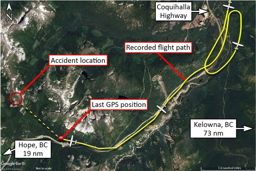
The Joint Rescue Coordination Centre in Victoria, British Columbia, received an emergency locator transmitter signal from the aircraft and initiated a search at approximately 1145. The initial search area was approximately 55 nm; however, low clouds and rain in the area hampered the search effort.
At approximately 1330 on 29 June 2018, the crash site was found 19 nm northeast of Hope, near Zupjok Peak. Both of the aircraft's occupants had been fatally injured. The aircraft had been destroyed by ground impact and a subsequent fire.
Meteorological information
The pilot obtained a weather briefing for the intended route via telephone from the Edmonton Flight Information Centre at 0548 and again at 0818 before filing the VFR flight plan. The briefing provided the following information for the intended route:
- local ceilings at 1500 feet AGL
- cloud bases at 8000 feet with tops at 20 000 feet AGL (between Calgary and Hope)
- isolated towering cumulus cloud
- visibility: 6 statute miles
- scattered showers
- ceilings at 6000 to 7000 feet AGL, with increasing cloud west of Hope
While in flight, the pilot made radio contact twice with a commercially operated helicopter travelling a similar routeNote de bas de page 3 near Rogers Pass, British Columbia. Weather observations were exchanged between the pilots. The helicopter was travelling a few minutes ahead of the occurrence aircraft and at a lower altitude.
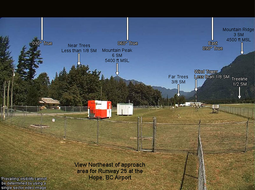
NAV CANADA operates automated weather cameras and an automated weather observation system at Hope Airport (CYHE), British Columbia. Figure 2 and Figure 3 show views from the northeast taken by the NAV CANADA cameras on a clear day and on the day of the occurrence.
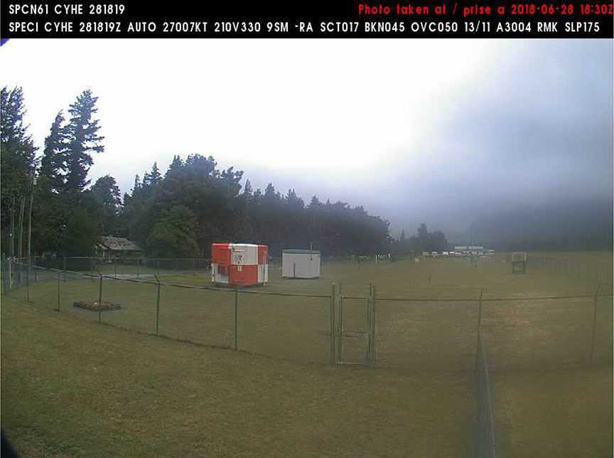
The automated weather observation system information from CYHE for 1119, approximately 16 minutes before the occurrence, indicated the following:
- temperature: 13 °C
- dew point: 11 °C
- scattered cloud at 1700 feet, broken cloud at 4500 feet, overcast at 5000 feet AGL
- visibility: 9 statute miles in light rain
- wind: 7 knots variable from 210° to 330° true (T)
- barometric pressure: 30.04 inHg
Intermittent rain and low ceilings were reported in the Coquihalla Summit Recreation Area around the time of the occurrence. More specifically, thick cloud had accumulated along the mountains and against the slopes, obscuring the mountain tops.
Aircraft
The occurrence aircraft was certified, equipped, and maintained in accordance with existing regulations and approved procedures. It had no known deficiencies and was being operated within its weight and balance and centre of gravity limits. The aircraft was not equipped with a flight recorder, nor was it required by regulation. The aircraft had been modified with an upgraded avionics package that had the capabilities to provide the pilot with terrain awareness and weather information; however, the configuration of the system at the time of the accident could not be determined. The aircraft was also equipped with an automatic dependent surveillance - broadcast (ADS-B) system.Note de bas de page 4
Pilot and passenger
Records indicate that the pilot was certified and qualified for the flight in accordance with existing regulations. He held a valid private pilot licence, originally issued in July 2009, and a Category 3 medical certificate. The pilot had accumulated in excess of 700 hours total flying time. He had obtained VFR over-the-topNote de bas de page 5 and night ratingsNote de bas de page 6 on his licence. He did not hold an instrument flight rating.
The passenger held a valid private pilot licence and a Category 3 medical certificate. Records indicate that he had accumulated in excess of 400 hours total flying time.
Impact and wreckage information
Examination of the wreckage did not reveal any pre-existing mechanical conditions that could have contributed to the crash. All on-board flight instruments were destroyed. A portable GPS unit was found at the wreckage site and sent to the TSB Engineering Laboratory in Ottawa, Ontario, for data retrieval. The GPS provided a flight track for the occurrence flight.
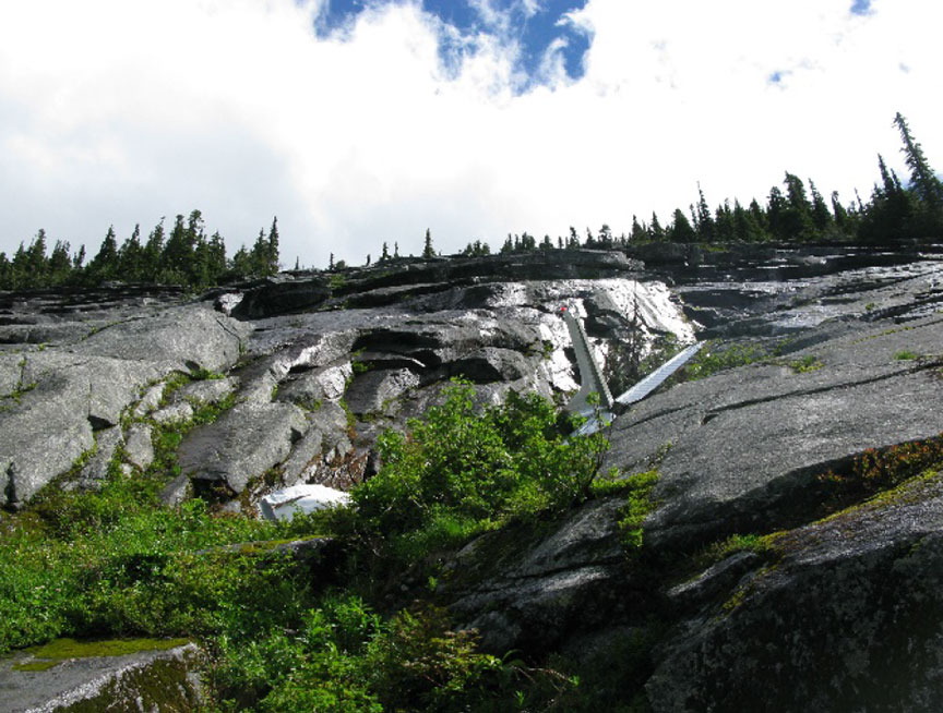
The aircraft struck Zupjok PeakNote de bas de page 7 on the northeast-facing slope at an elevation of 5800 feet. The aircraft then slid down the granite rock and came to rest at an elevation of 5200 feet (Figure 4), where it was consumed by fire.
Visual flight rules flight over mountainous terrain in deteriorating weather conditions
The hazards associated with continuing VFR flight into instrument meteorological conditions are well documented. According to data collected by the TSB between 2000 and 2014, accidents involving flights that depart under visual meteorological conditions and continue to a point where pilots lose visual reference with the ground have a high fatality rate. Over the 15-year period, these types of accidents resulted in 74 fatalities.
In addition, factors such as flight experience, instrument training, and aircraft equipment must be considered during pre-flight planning to mitigate against in-flight hazards, such as encountering deteriorating weather conditions, particularly in mountainous terrain. Furthermore, lapses in critical piloting skills, such as decision making, maintaining situation awareness, and interpreting changing weather conditions, may exacerbate flight in such challenging conditions, increasing the likelihood of controlled flight into terrain (CFIT).
The Flight Safety Foundation defines CFIT as “when an airworthy aircraft under the control of the flight crew is flown unintentionally into terrain, obstacles, or water, usually with no prior awareness by the crew.”Note de bas de page 8
This type of accident often occurs in low visibility, at night, or in poor weather. These conditions reduce the pilot's awareness of the surrounding area and make it difficult to visually determine the aircraft's proximity to terrain. The risk of accident is even greater for aircraft that fly in mountainous terrain.
Safety message
Flying in deteriorating weather conditions is challenging; the associated risks need to be managed properly before and during flight, especially when flying over mountainous terrain.
This concludes the TSB's limited-scope investigation into this occurrence. The Board authorized the release of this investigation report on . It was officially released on .