Main track derailment
Canadian Pacific Railway
Freight train 679-101
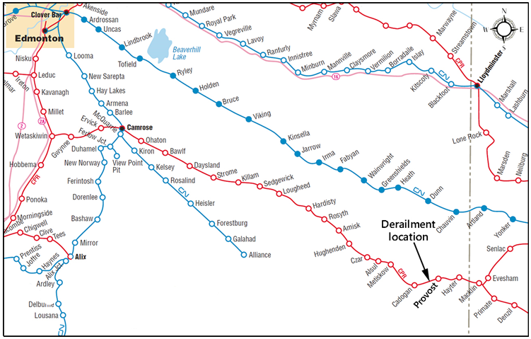
Mile 80.70 Hardisty Subdivision
Provost, Alberta
The Transportation Safety Board of Canada (TSB) investigated this occurrence for the purpose of advancing transportation safety. It is not the function of the Board to assign fault or determine civil or criminal liability. This report is not created for use in the context of legal, disciplinary or other proceedings. See Ownership and use of content. Masculine pronouns and position titles may be used to signify all genders to comply with the Canadian Transportation Accident Investigation and Safety Board Act (S.C. 1989, c. 3).
Summary
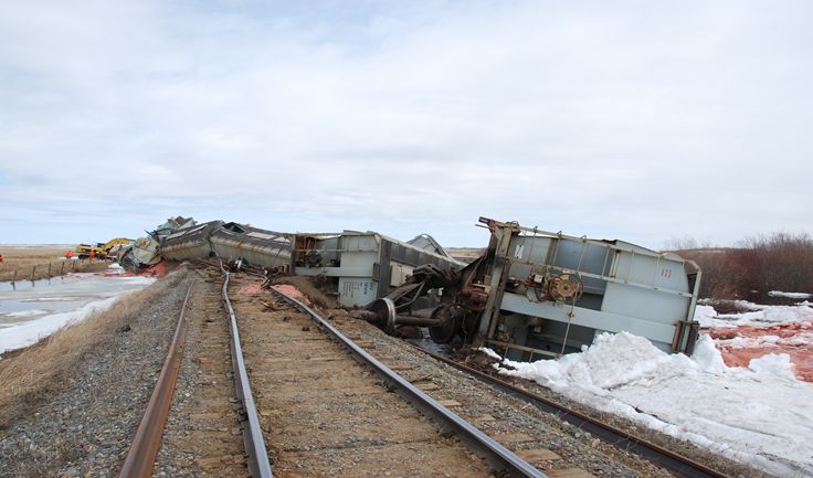
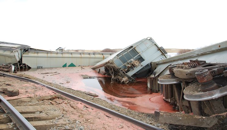
On 28 April 2013, at 0355 Central Standard Time, Canadian Pacific Railway freight train 679-101 was proceeding westward from Wilkie, Saskatchewan, to Hardisty, Alberta, when 17 of its cars, loaded with potash, derailed at Mile 80.7 on the Hardisty Subdivision, near Provost, Alberta. Approximately 350 feet of track was destroyed. There were no injuries.
Factual information
The accident
On 28 April 2013, at about 0044, Footnote 1 Canadian Pacific Railway (CP) freight train 679-101 (the train) departed Wilkie, Saskatchewan, destined for Edmonton Alberta. The distributed power train was being operated with five 6 axle, 4300 hp General Motors (GM) locomotives. 2 locomotives were located at the front of the train, 2 locomotives were located 85 cars behind the lead locomotives and 1 locomotive was located at the tail end of the train. The train was handling 170 railcars loaded with potash. It weighed 25 332 tons and was 8356 feet long.
At 0355, while travelling westward on the Hardisty Subdivision at about 23 mph, a train-initiated emergency brake application occurred. After making the necessary emergency broadcast and notifying the rail traffic controller (RTC), the conductor performed an inspection and determined that the 17th car behind the lead locomotives had been the first car to derail. A total of 17 cars had derailed beginning at Mile 80.70, near Provost, Alberta (Figure 1). The 17 derailed cars lost varying amounts of potash, either in the derailment or during the subsequent derailment recovery operation. There were no injuries.
Weather
The weather at the time of the occurrence was 2°C and mainly clear, as reported by Environment Canada's Cadogan Weather Station. In the 5 days preceding the occurrence, the daytime temperatures had been in the range of 9.2° to 20.9° C, which was warmer than normal. The area ditches had accumulated unusually deep and extensive localized snow drifts during the winter.
Site examination
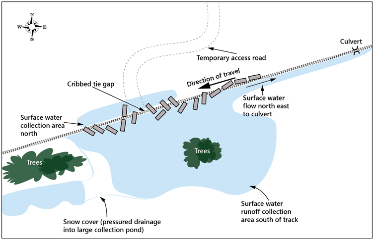
The derailment occurred in a rural area with no crossings or sidings in the vicinity. The point of derailment (POD) was determined to be at Mile 80.7 on tangent track. The first 4 cars had derailed to the south side of the track and had rolled down the bank into standing water. The remaining derailed cars came to rest on top of the track and on both sides (Figure 2). The track roadbed at this location was elevated above ground level (Photo 1). The standing water on the north side of the track was approximately 2 feet deep and 6 feet below the level of the rail. The standing water on the south side of the track was significantly deeper and was within 3 feet of the level of the rail (Photo 2).
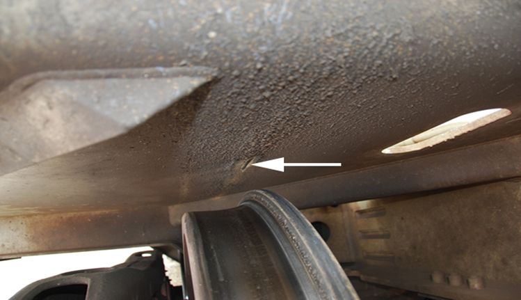
The front of the train (i.e., 16 cars and 2 locomotives that were ahead of the derailment) was inspected. Impact marks were observed on the deck plates Footnote 2 of the first 16 cars, indicating that they had been struck from beneath by the leading wheelset on each of the cars (Photo 3).
Crew information
The train crew consisted of a locomotive engineer and a conductor. Both crew members were qualified for their respective position, met rest and fitness standards, and were familiar with the subdivision.
Recorded information
Information from the locomotive event recorder (LER) was reviewed. It was determined that the train was travelling at 23 mph when a train-initiated emergency brake application occurred at 0355:12. The throttle was in notch 5 and all brakes were released.
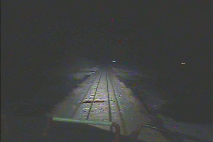
A forward facing video camera had been installed on the lead locomotive. The recorded video indicated that 3 cribbedFootnote 3 ties were clearly visible as the train approached the POD (Photo 4).
Subdivision information
The Hardisty Subdivision runs west from Wilkie, Saskatchewan (Mile 0.0) to Hardisty, Alberta (Mile 131.4). Train movements are governed by the Occupancy Control System (OCS), as authorized by the Canadian Rail Operating Rules (CROR) and supervised by a rail traffic controller located in Calgary, Alberta.
The Hardisty Subdivision is part of CP's Prairie North Line between Edmonton, Calgary and Winnipeg. CP began operating loaded unit potash trains over this line in April 2013. The potash trains originate in Saskatchewan and travel to the port of Vancouver. Train 679-101 was the fifth such train. Rail traffic over the Hardisty Subdivision had increased from 7.0 million gross tons (MGT) in 2011 to 8.8 MGT in 2012, a 13% increase. The railway expects that approximately 40% of the 2013 traffic operated over this subdivision will be bulk commodity unit trains.
Railways have some flexibility to choose their traffic, operating and maintenance practices, including the routes over which the traffic is moved. By using its northern route for certain west coast unit train traffic, CP can intensify utilization of its secondary network. This can result in increased operational efficiency by minimizing main-line congestion as more slots are available for priority trains. Consideration of the type of traffic to be handled is an important preparatory aspect to managing infrastructure.
Track information
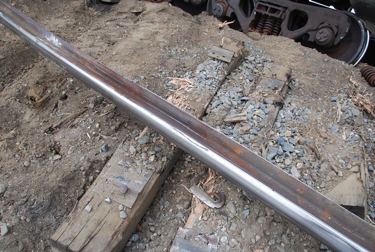
The track leading up to the derailment location was lying on a 0.4% ascending grade, transitioning to level track. The rail in the area of the derailment was 100-pound jointed rail manufactured by Algoma in 1929. The ties were 8 foot, treated No. 1 softwood ties. The tie plates were single shoulder with 2 spikes per plate. The condition of the tie plates was generally poor with broken plates at some rail joints. FAIRFootnote 4 rail anchors were installed to every second tie. The rail anchors displayed evidence of rail movement. The ties and spikes were in fair condition. Ballast consisted of a surface sprinkling of grade 3 ballast (i.e., mainly sand and gravel less than 2 inches) and was fouled (Photo 5).
The roadbed was approximately 10 feet above the local terrain and had been constructed in the early 20th century using in-situ sand, gravel and clays. It reflected the construction technology of the day and was considered adequate for a relatively dry prairie environment and the level of traffic at the time. Although the subgrade had been compacted over the years by the passage of trains, it had remained susceptible to water infiltration.
There had been no reported drainage problems in the area of the derailment. Local observations were that the area was generally dry. A culvert was in place at Mile 80.5, about 1000 feet east of the POD, to facilitate drainage water to flow south to north. Excess water would normally flow from the west and pass through the culvert, but ice in the south ditch restricted flow to the culvert allowing water to back up in the ditch.
The maximum permissible freight operating speed through the derailment area was 30 mph; for Class 3 track, the maximum freight train speed is 30 mph. At the time of the occurrence, a slow order of 25 mph was in force due to a narrow gauge condition, effectively lowering the track classification to Class 2.
Major track upgrade programs had been scheduled, but had not started on the Hardisty Subdivision. This planned upgrade work, which was to be completed over 4 years, included relaying continuous welded rail (CWR) and performing track surfacing between Mile 70 and Mile 95.
Track inspection and maintenance
The track had been inspected by a certified track inspector with a hi-rail vehicle on April 26 and 27, in the 2 days prior to the occurrence. No track defects were noted in the vicinity of the derailment. Track inspections were being conducted on a daily basis to identify potential problems due to the spring thaw and the recent increase in rail traffic.
CP's Track Evaluation Car had conducted track geometry tests on the Hardisty Subdivision on 26 May 2012 and 01 November, 2012. Between Mile 80.6 and Mile 80.8, there were 6 urgent Footnote 5 narrow gauge defects and 23 priority Footnote 6 surface defects on the May 26 test and 20 priority surface defects on the November 01 test.
At this location, the last track maintenance work had occurred in July 2012, when a ballast skin lift was performed (i.e., a minor re-adjustment of the ballast around the ties).
In the recent past, there had not been any track or roadbed anomalies at this location. Also, there had not been any reports of potential roadbed instability. Regular track inspections did not identify the ongoing water saturation of the subgrade and the weakening of the track support system.
A review of Vehicle/Track (VTI) Footnote 7 locomotive records for the period January 01, 2013 through April 28, 2013 did not reveal any defects in the vicinity of the POD.
CP Engineering employees were trained on geotechnical issues (i.e., “Geotechnology for Railroaders”, which included the assessment of high water conditions) in 1997 and 1998. Engineering employees had recently begun re-training in similar issues (i.e., “Recognizing Geotechnical Hazards”).
Transport Canada inspections
Transport Canada is responsible for setting safety standards for railway operations and overseeing the safety of such operations. As part of TC's oversight activities, Railway Safety Inspectors (RSI) gather information through audits and track inspections to determine whether a railway is managing its track safely. A typical track inspection consists of a review of railway practices along with a visual inspection of the track. These inspections enable Transport Canada to evaluate the effectiveness and adequacy of the railways inspection programs and to determine compliance with the Track Safety Rules (TSR).
For the past few years, TC has enhanced its visual inspections by using hi-rail based geometry-measuring systems. The use of a Track Assessment Vehicle (TAV) enables current, accurate, real time track geometry data gathering to determine whether the track meets the requirements of the TSR.
The use of TAV is not considered to be a geometry test nor a substitute for an inspection to be performed by a railway company as per the requirements of the TSR. Rather, it is a tool provided to the RSI to supplement visual inspections. TC inspectors use the TAV evaluations to assess sample track segments, which helps determining how a railway is managing the safety of its track infrastructure.
The condition of the Hardisty Subdivision had attracted TC's attention in the past. Following a rail safety inspection in September 2006, TC issued a Notice per Section 31 of the Railway Safety Act regarding a threat to safe railway operations due to the degraded condition of the track structure and the sub-standard maintenance of the line. Following some track upgrade work and additional track geometry tests, rail flaw tests and track inspections, the Notice was removed in November 2012.
In September 2012, a track geometry TAV test was conducted between Mile 62 and Mile 129.4. A total of 260 urgent narrow gauge defects were identified. These gauge defects were attributed to tie plates, which were either broken or unsecured on defective ties. The 25 mph slow order in force made the track compliant with the TSR. A speed restriction was imposed on one curve, which had a number of elevation and curvature defects. Insufficient ballast on the shoulder and in tie-cribs was noted at several locations.
Rail testing
A rail flaw detection testFootnote 8 was conducted in the vicinity of the derailment on 17 April 2013. A head and web separation defectFootnote 9 at a joint was detected at mile 80.73. The defect was protected by CP's Redbook of Track Requirements 16.5.0, protection code 7, which restricts train speed to no more than 30 mph as designated by a qualified track supervisor, or the maximum allowable speed under the class of track, whichever is lower. At this location, the maximum allowable speed was reduced to 25 mph. The defect had not yet been repaired when the derailment occurred.
Car and locomotive information
The railcars involved in the derailment were covered hoppers. The train was assembled in Dunfermline, SK, at a Potash mine located 16.5 km west of Saskatoon, SK. The train had undergone a No. 1A brake test and a pre-departure inspection in Dunfermline and had departed at 2130 on 27 April 2013. Some blocks of cars in the train had been inspected by a Certified Car Inspector and had undergone a No. 1 Air Brake test in Moose Jaw, SK on 01 April 2013. The remainder of the railcars received their certified car inspection and No. 1 brake test in Lethbridge, AB on 14 April 2013.
No pre-existing conditions or defects were observed on any of the derailed rolling stock.
The train was inspected by a hot box and dragging equipment detector at Mile 57.3 of the Hardisty subdivision: no integrity alarms were raised.
Previous train traffic
On 27 April 2013, eastbound CP freight train 298-27 was the last train that passed over the POD - at 1938:23 MDT – before the occurrence train. This train consisted of 95 loaded cars and 19 empty cars and weighed 14,666 tons. The train was powered by 3 head end locomotives and 1 tail end locomotive. Nothing unusual was observed in the area of the POD by the crew of that train. Video footage from the lead locomotive of that train at the derailment location does show water flowing from the south to north ditch and an apparent loss of ballast within the gauge, but the video is not that clear in the diminishing daylight.
Analysis
Neither the condition of the rolling stock nor the manner in which the train was operated was considered contributory to this accident. The analysis will focus on the condition of the track and roadbed in the area of the derailment.
The accident
The derailment occurred when the train passed over a track irregularity due to a track subgrade failure. The subgrade failure occurred at a location where there were 3 - 4 cribbed ties. The previous train and the head end locomotives along with the first sixteen cars of train 679-101 made it safely over the tie gap. However, with the passage of rolling stock, more ballast and subgrade material fell into the gap, which extended. The leading wheelsets of car 12 to car 16 impacted the deck plates located on the underside of the cars as they passed over the tie gap. Eventually, the vertical force of the heavily loaded unit train on the poorly supported cribbed tie gap resulted in the failure of the track structure, leading to the derailment of the 17th to 33rd cars. The impact marks on the underside of the car deck plates, three partially cribbed ties and the layout of the derailed cars indicate that a sudden failure of the subgrade occurred under the train.
The roadbed was approximately 10 feet above the local terrain and had been constructed in the early 20th century using in-situ sand, gravel and clays. Although the subgrade had been compacted over the years by the passage of trains, it had remained susceptible to water infiltration.
In the 4 days prior to the occurrence, daytime temperatures had been abnormally warm followed by cooler nights, which had resulted in a steadily increasing seasonal run-off water volume from the melting snow. The natural drainage at this location was from the west. Excess water would normally pass through a culvert east of the POD to the north side of the track. However, ice in the south ditch restricted the flow of the high volume of run-off water from the rapidly melting snow, allowing the water to back up in the ditch. It is also possible that the culvert itself was partially iced up. Due to the limited capacity of the drainage system and the southern exposure, the water level remained higher on the south side of the track relative to the north side, resulting in above normal water level infiltration and saturation of the track subgrade.
The daily temperature variations resulted in freeze and thaw cycles that produced excess free water in the track subgrade. This excess water decreased the normal internal soil friction, leading to reduced cohesion, stability, and bearing support. This sustained infiltration created elevated water pressures (pore pressure) that resulted in surface water migration through the railway embankment from the south to the north. This water flow through the subgrade created a void below track level as ballast and subgrade material were lost from between and beneath the ties, reducing the capacity of the track to support the passing train.
Geotechnical hazards and track inspection
At CP, much of the training program relating to geotechnical hazards and the spring preparedness plans were specifically designed to prevent derailments attributable to roadbed failure during the spring thaw period. The detection of a weak track subgrade is an important component of the track inspection regimen. In this occurrence, the presence of elevated water levels on one side of the track was an indicator of poor track drainage and the possibility of track weakness in the area of the derailment. If geotechnical hazards are not specifically identified and addressed, track structure degradation may occur, increasing the risk of derailments.
Findings
Findings as to causes and contributing factors
- The derailment occurred when the train passed over a track irregularity due to a track subgrade failure.
- Due to the limited capacity of the drainage system, the water level was higher on the south side of the track relative to the north side, resulting in above normal water infiltration and saturation of the track subgrade.
- The water flow through the track subgrade created a void below track level as ballast and subgrade material were lost from between and beneath the ties, reducing the capacity of the track to support the passing train.
- The vertical force of the heavily loaded unit train on the poorly supported cribbed tie gap resulted in failure of the track structure.
Findings as to risk
- If geotechnical hazards are not specifically identified and addressed, track structure degradation may occur, increasing the risk of derailments.
This report concludes the Transportation Safety Board’s investigation into this occurrence. the Board authorized the release of this report on . It was officially released on 31 March 2014.