Grounding and constructive total loss
the bulk carrier Alcor
Traverse du Nord, St. Lawrence River
AND
Subsequent near-collision between
the tanker Eternity and
the container ship Canmar Pride
The Transportation Safety Board of Canada (TSB) investigated this occurrence for the purpose of advancing transportation safety. It is not the function of the Board to assign fault or determine civil or criminal liability. This report is not created for use in the context of legal, disciplinary or other proceedings. See Ownership and use of content. Masculine pronouns and position titles may be used to signify all genders to comply with the Canadian Transportation Accident Investigation and Safety Board Act (S.C. 1989, c. 3).
Summary
On 09 November 1999, the loaded bulk carrier Alcor was upbound for Trois-Rivières, Quebec, on the St. Lawrence River, under the conduct of a pilot. At 1444 local time, while undertaking a course alteration to starboard, the vessel ran aground near the eastern end of Île d'Orléans. A refloating attempt the next evening succeeded in freeing the vessel, but only briefly, and the vessel grounded a second time near the initial grounding position. The Alcor sustained major hull damage near midships due to bending forces incurred during successive low-tide cycles.
The damaged hull was temporarily repaired and roughly half of the cargo was discharged onto smaller vessels. On December 5, the Alcor was refloated and conducted to the port of Québec. It was declared a constructive total loss.
While the Alcor was being refloated and later, while the vessel was upbound with the assistance of tugs, the Traverse du Nord section of the river was temporarily closed. The closure caused several downbound vessels to anchor upriver. The subsequent re-opening of the channel resulted in a confluence of vessels wishing to depart their anchorages. During this time, a near-collision occurred between the tanker Eternity, under way, and the container ship Canmar Pride, at anchor.
Part A - Grounding
A 1.0 Factual Information
A 1.1 Particulars of the Vessel
| Name | "ALCOR" |
|---|---|
| Official number | 7533159, International Maritime Organization (IMO) |
| Port of registry | Valletta |
| Flag | Malta |
| Type | Dry Bulk Carrier |
| Gross tonnageFootnote 1 | 16 136 |
| Deadweight Tonnage | 27 536 |
| LengthFootnote 2 | 178.2 m |
| Draught | Forward: 10.02 m Aft: 9.95 m |
| Built | 1977, Japan |
| Propulsion | Sulzer Sumitomo marine diesel engine, 11 400 brake horsepower (8385 kilowatts) driving a single fixed-pitch propeller |
| Cargo | 23 693 tonnes (t) of cement clinker, in bulk |
| Crew | 25 |
| Owner | New Wind Shipping Company Ltd., Valletta, Malta |
| Operators | Transorient Overseas S.A., Piraeus, Greece |
A 1.1.1 Description of the Vessel
The Alcor was a single-deck, dry bulk cargo vessel of all-welded steel construction. The propulsion machinery, electro-hydraulic steering gear, wheelhouse and crew accommodation were all arranged at the after end of the vessel. It was manoeuvred by a single balanced centre-line rudder.
The location of the five cargo holds, water ballast tanks and oil fuel tanks is shown in Appendix C (Outline General Arrangement). Cargo hold 3 could also be used as a water ballast (deep) tank. The hull was subdivided by seven transverse watertight bulkheads, together with an inner bottom watertight tank top, which extended fore and aft throughout the cargo holds and the engine room. The main deck, upper wing tanks, inner bottom and bottom shell plating were framed longitudinally in way of the cargo holds. The single side shell plating in way of the cargo holds and upper wing ballast tanks was framed transversely.
A 1.2 History of the Initial Grounding
A 1.2.1 The Transit
On 30 October 1999, the Alcor departed Venezuela, bound for Trois-Rivières, Quebec. The voyage north was made through heavy weather, with the vessel pitching and rolling heavily. Deck log book entries show winds of force 5 to 7 (17 to 33 knots), with two to three metre swells. On 05 November 1999, the vessel reduced speed for a time to reduce rolling/pitching and wave impact forces.
By 09 November 1999, the vessel had reached the Les Escoumins pilot boarding station in the St. Lawrence River. Draughts at this time were reported as 10.02 m forward and 9.95 m aft. At 0515Footnote 3, a river pilot boarded to take conduct of the vessel up to Québec, whereupon, after a scheduled pilot change, the vessel was to be conducted to Trois-Rivières. The voyage upriver was uneventful, with the vessel proceeding at full manoeuvring speed. In deep water, without the effects of wind or tide, this would have given a speed of approximately 11 knots. Initially, the ebb tide slowed the vessel's speed over the bottom, at times to 7 or 8 knots.Footnote 4 As the vessel progressed upriver, the flood tide gradually caught up with the vessel and her speed over the bottom increased. By 1400, the vessel had reached Sault-au-Cochon and her speed was about 13 knots.
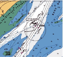
At approximately 1415, the Alcor entered the more restricted waters of the North Channel (traverse du nord) near Cap Gribane. As the vessel settled on the leading lights of 213½° True (T), the pilot confirmed his belief that the steering gyro compass repeater was showing 1° low. At the next course alteration point, Cap Brûlé, to the leading lights of 204° T, the pilot ordered a course of 201° gyro (G) to compensate for the 1° low steering repeater and the flood tide acting in a southwesterly direction. Approaching buoy K-108, the vessel was approximately 60 m to starboard of the centre of the channel, and now making 14 knots. The current was setting approximately 215° T at between 2.5 and 3.5 knots. Buoy K-108 was the location of the next course alteration, to starboard, to make the next set of leading lights, also of 213½° T. The only other river traffic in the vicinity was a downbound vessel ahead at between 1½ and 2 nautical miles (nm). (see Figure 4 for General Area Chart.)
A 1.2.2 The Grounding
The bridge watch at this time consisted of the second officer, who was the officer of the watch (OOW), the pilot, who had conduct of the vessel, and the helmsman, who was at the main steering console carrying out helm orders. The master was on the port bridge wing and the door separating the bridge wing exterior and the wheelhouse interior was ajar.
Between 1437 and 1438, with the vessel's bow about one cable below buoy K-108, the pilot requested a course alteration. According to some accounts, this was a course-to-steer order of 212° G, while according to other accounts, it was a helm order "starboard ten." The helm was placed 10° to 15° to starboard by various accounts. Soon after the helm was put over to starboard, the pilot requested more helm by using the command "more". The helmsman looked to the OOW for guidance and the OOW directed him to increase helm by 5°. He immediately put 5° more helm to starboard. The pilot, seeing the ship's head remain immobile, requested more helm by repeating "more". The helmsman applied another 5° of starboard helm. Some accounts of the events have the pilot requesting, for a third time, "more" - and an additional 5° helm was applied at this time. All concur, however, that the vessel's head was now starting to swing very slowly to starboard and the vessel's rudder was between 20° and 30° to starboard.
Unsatisfied with the vessel's rate of turn, the pilot removed the helmsman from his position at the steering console and took the wheel himself. According to one account, the pilot then turned the wheel to starboard once or twice to bring the rudder hard to starboard, 35°. However, according to other accounts, the pilot turned the wheel to starboard five to seven times, in a highly energetic fashion. Either action would have produced the same result, 35° of starboard helm. (The wheel had a slip clutch, whereby any excess turn of the wheel past the maximum did not impart further electrical signals to the steering gear.)
Having turned the wheel to starboard, the pilot immediately started turning the wheel quickly in the opposite direction and put the wheel 35° to port. The pilot noticed that the rudder angle indicator remained at 35° to starboard, and he informed the OOW of this. Some accounts have the OOW and the pilot both trying the non-follow-up (NFU) lever at this point, but others do not. Leaving the steering console, the pilot went to the very high frequency (VHF) radio to warn the downbound vessel of their situation. After this short conversation (in French), the pilot went quickly to the central control panel and put the engine-room telegraph to full astern.
While the pilot was occupied with the VHF conversation and the engine-room telegraph, the OOW approached the steering console and twice toggled the steering mode selector (SMS) switch, leaving the switch at the HAND position. He then saw the rudder angle indicator begin to move to port. At some time during these events, the OOW put the wheel to midships. He then went to the ship's public address system and announced the steering problem.
The first engineer, who was on the main deck close to the steering gear flat access door, ran immediately to this location upon hearing the announcement. As he entered the steering gear flat, he noticed the rudder was at the midship position. The time interval between the announcement by the OOW and the first engineer's arrival at the steering gear flat was about 15 seconds. He quickly verified that both steering gear pumps were on. By this time, the ship's electrician had joined the first engineer in the steering gear flat and was assisting. In order to verify the steering gear operation locally, the ship's electrician activated the switch isolating the steering gear from the bridge. The first engineer then turned the rudder a few degrees to port and to starboard locally, using the "trick wheel". The rudder responded to the trick wheel, so the bridge isolation switch was repositioned to give control back to the bridge. He then called the bridge on the sound-powered telephone and reported that the steering gear was functioning satisfactorily. The above sequence of events is summarized in Table 1.Footnote 5
| Time | Event | Result | Observations | |
|---|---|---|---|---|
| 1437:50 | 10° (or 15°) starboard helm applied | Rudder angle indicator to starboard correspondingly | No change in heading | |
| 1437:55 | 5° additional starboard helm applied | Rudder angle indicator to starboard - now 15° or 20° | No change in heading | |
| 1438:00 | 5° additional starboard helm applied | Rudder angle indicator to starboard - now 20° or 25° | OOW notices slight starboard swing | |
| 1438:05 | 5° additional starboard helm applied | Rudder angle indicator to starboard - now 25° or 30° | Pilot notices slight starboard swing | |
| 1438:10 | Pilot takes wheel and turns (many times) to starboard | Rudder angle indicator goes to hard starboard - 35° | Vessel swinging to starboard | |
| 1438:15 | Pilot turns wheel many times to port | Rudder order hard to port | Rudder angle indicator remains hard to starboard | rudder not responding to helm |
| 1438:20 | Pilot informs OOW that rudder is not responding, then leaves helm to warn downbound vessel on VHF radio | OOW approaches helm | ||
| 1438:25 | Pilot on radio | Pilot on radio (from time stamp of Vessel Traffic Services [VTS] recording) | ||
| OOW assumes helm, appraises situation | ||||
| 1438:30 | OOW toggles the SMS switch twice, leaving the switch at the HAND position | Rudder angle indicator starts to move to port | OOW and helmsman see rudder angle indicator coming to port | |
| 1438:35 | OOW puts wheel to midships position | Rudder angle indicator stops at midships position | ||
| Pilot puts engine full astern | Engine-room crew alerted to unusual situation by full astern order | |||
| 1438:40 | Engine-room crew in control room begin emergency braking on engine | Main engine r/min of engine starts to decrease | ||
| OOW makes announcement on ship's PA about steering gear problem | First engineer (in passageway adjacent to steering gear flat) hears announcement and runs to steering gear flat | Chief engineer hears announcement and looks at rudder angle indicator in control room. He sees it amidships. | ||
| 1438:55 | First engineer arrives at steering gear flat | First engineer starts steering gear verification | Upon arrival in steering gear flat, first engineer sees rudder amidships | |
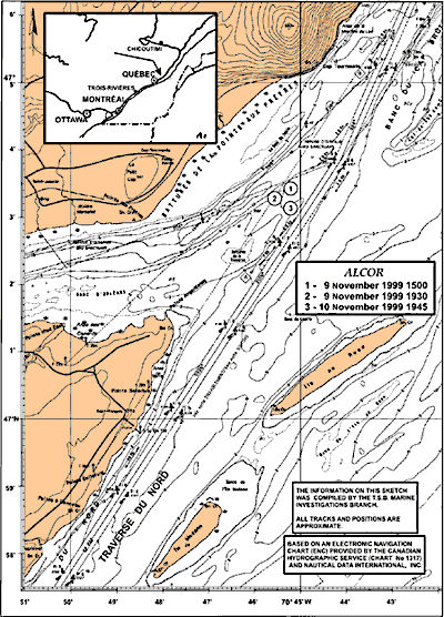
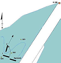
By this time (1440), the ship was veering out of the channel on a heading of approximately 265° T. The master had already re-entered the wheelhouse interior and was assisting the navigation team. The chief officer had come to the wheelhouse and quickly deployed to the forecastle to standby the anchor. Shortly afterward, the astern thrust became effective and the vessel slowed considerably. The pilot was informed at or about this time that the rudder was responding to helm action. By 1444, the vessel had effectively come to a stop. Engine movements ahead were attempted in the hope of reaching deeper water, barely one cable ahead, but to no avail. The starboard anchor was then let go. The vessel was now aground, at position latitude 47°03′ 29.5″ N, longitude 070°45′ 09.1″ W, on a heading of approximately 285° T. (see Figure 1 for the vessel track as recorded by the pilot's portable differential global positioning system [DGPS].)
At 1444, the pilot reported to VTS that the vessel had left the channel but that they were not yet aground. At 1506, VTS asked the pilot if they needed assistance. The pilot responded that he thought the vessel could come free but would consult with the master. He also confirmed that the rudder was now working. At about this time, VTS inquired whether they required a speed reduction for vessels transiting the area. The pilot responded in the negative. At 1540, the pilot reported to VTS that they were still trying to extricate the vessel.
Immediately after the grounding, the master contacted the owners to consult about tugs. About one and a half hours after the grounding, at 1615, one tug was ordered via VTS. The tug Ocean Charlie left Québec at 1705 and arrived on scene at 1930, one and a quarter hours after high tide. Although on approximately the same heading of 285°, the Alcor had moved 2½ cables to the southwest, pushed by the flood tide current, and had settled in water between four and six metres above chart datum, in position latitude 47°03′ 18″ N, longitude 070°45′ 33″ W. No attempt was made to refloat the vessel at this time, as the tide had already dropped by about one metre. After consulting with officials of the Corporation des Pilotes du Bas Saint-Laurent (Pilot Corporation) by cellular telephone, the pilot decided to remain on board and assist.
By 1700, Transport Canada (TC) officials had arrived on board. Shortly after their arrival they conducted their initial steering-gear tests, which showed that the steering gear appeared to be functioning adequately and within the prescribed time limits.Footnote 6 Soundings were taken throughout the ship. Hopper tanks 2 and 3 on the port side and hopper tank 3 on the starboard side were determined to be taking on water. At 1752, the pilot of the Alcor asked VTS for a speed reduction for local traffic.
A 1.3 Injuries to Persons
No one was injured as a result of this occurrence.
A 1.4 Initial Hull Damage
Hopper tanks (water ballast) 2 (S) and 3 (P) were holed as a result of the initial grounding. The hull later sustained further extensive damage (see Part B 1.3, Hull Failure).
A 1.5 Certification
A 1.5.1 Vessel
The vessel's Certificate of Maltese Registry, Certificate of Class, International Load Line Certificate, Construction Certificate, Safety Equipment Certificate, and Radio Station Certificate were valid and appropriate to the service in which she was engaged.
Classification-related inspections and surveys of the Alcor were carried out on behalf of the owner by the Russian Maritime Register of Shipping (RS). International regulatory and national registry certification-related inspections were carried out by RS on behalf of, and under the authority of, the Government of the Republic of Malta.
The safety management systems of both vessel and management were audited by RS, and found to be in accordance with the requirements of the International Safety Management Code (ISM Code). The vessel's Safety Management Certificate was valid until April 2003; the managers' Document of Compliance was valid until March 2003.
A 1.5.2 Personnel
Certificates of competency for the master and officers were valid and complied with the provisions of the International Convention on Standards of Training, Certification, and Watchkeeping for Seafarers. The certificates were appropriate to the service in which the vessel was engaged. Qualifications of the crew were in accordance with regulatory requirements.
The master possessed a Master Mariner certificate, issued on 15 May 1992 in Ukraine.
The OOW possessed a certificate of an officer in charge of a navigational watch, issued on 14 March 1995 in Ukraine.
The pilot possessed a Master Mariner certificate, issued on 05 May 1994. He had acquired his Class C pilotage licence on 01 April 1998. Following a regulatory change that had come into effect 20 days before the accident, he was entitled to a Class C-1 licence (ships up to 30 000 deadweight tons (DWT)) with the coming into force of the amended regulation on 21 October 1999. His pilotage licence was thus amended to this higher tonnage on 02 November 1999.
A 1.6 Personnel History
The master had been at sea for 39 years, the last 10 years as master on various ships. He had been on the Alcor since 09 April 1999.
The OOW had been at sea on various ships as an OOW since May 1995. He had joined the Alcor on 09 April 1999.
The pilot had begun his sea experience as OOW in 1989. In 1992, he obtained his Master Home Trade certificate and his Master Mariner certificate in 1994. Prior to entering the Pilot Corporation, he served on ocean-going vessels as OOW for a total of 45 months' sea-time. He began his pilotage apprenticeship on 01 April 1996 and was granted his pilotage licence on 01 April 1998 having completed 226 trips on vessels of all sizes as an apprentice pilot. Since 01 April 1998 and until the Alcor assignment, he had performed approximately 175 pilotage assignments. It was his first experience on this vessel.
A 1.7 Weather, Current and Tide
A 1.7.1 Wind, Seas and Visibility
At the time of the initial grounding, on the afternoon of 09 November 1999, winds were 10 to15 knots, generally from the northeast. Visibility was good and seas were calm.
A 1.7.2 Current at the Time of Grounding
The most significant currents in the St. Lawrence estuary between Trois-Rivières and the Saguenay River are the product of tidal forces.Footnote 7 In the area of the grounding, the current changes direction from a southwesterly (upstream) flow with the flood tide to a northeasterly (downstream) flow with the ebb tide. This change in direction comes about gradually, starting about 50 minutes after high water is reached at this point. The maximum force of the tidal current varies with the tidal range, and can exceed 3 knots. At the time of the grounding, the tidal current was setting approximately 215° T at between 2.5 and 3.5 knots.
A 1.7.3 Tide
In the St. Lawrence River, tidal forces reach as far upstream as Trois-Rivières, diminishing to nearly zero on Lac Saint-Pierre.Footnote 8 The tides are a mixture of diurnal and semi-diurnal, although the semi-diurnal oscillation dominates. The result is a semi-diurnal cycle that differs in height and duration from one cycle to the next. Although the maximum tidal range is experienced at Île-aux-Coudres (7.1 m), very large ranges are experienced as far upstream as Québec (5.8 m). The reference Port of Saint-François, Île d'Orléans, some 4 nm upstream of the grounding site, has a maximum tidal range of 6.6 m.Footnote 9 The measured tidal values, in metres, for this reference port on November 09, 10, and 11 were as follows:
| Date | November 9 | November 10 | November 11 | ||||||||||
|---|---|---|---|---|---|---|---|---|---|---|---|---|---|
| Time | 0115 | 0615 | 1300 | 1815 | 0145 | 0645 | 1345 | 1851 | 0230 | 0710 | 1410 | 1930 | |
| Height | high | 5.20 | 585 | 5.40 | 5.96 | 4.85 | 5.40 | ||||||
| low | 0.40 | 0.55 | 0.58 | 0.80 | 0.65 | 0.55 | |||||||
The time of the course alteration off buoy K-108, 1437, was 1 hour and 37 minutes after the measured low tide of 0.55 m. The measured tidal height at this time was 2.2 m above chart datum. The static under-keel clearance of the Alcor in the dredged channel at this time and location was, therefore, approximately 6.7 m. The measured rate of rise of the tide at this time was in the order of 1.3 m/h.
A 1.8 Bathymetry and the Navigable Channel - Traverse du Nord
From the Les Escoumins pilot station to Québec, the river channel is generally between 1 and 4 nm wide, and almost always deeper than 20 m. At Cape Gribane, however, the navigable channel narrows to 305 m, and the depth decreases. This stretch of river, between Cap Gribane and Pointe Saint-Jean, is commonly referred to as the Traverse du Nord. In the Traverse du Nord, there are two course alterations: for an upbound vessel, the first alteration is 9.5° to port at buoy K-100, the second is 9.5° to starboard at buoy K-108. The first turn has a minimum depth of 17 m and the deep water continues well beyond the buoyed channel. In the area of the second turn, near K-108, there is natural silting that requires regular dredging to maintain the guaranteed 12.5 m depth and, in this case, was actually about 14.5 m due to the dredging safety factor. Additionally, the 10 m depth contour hugs the limits of the buoyed channel at this point.
A 1.9 Navigation and Steering Equipment
A 1.9.1 Navigation Equipment
The Alcor is equipped with all electronic aids to navigation required by international conventions, including X- and S-band radars, supplemented by a global positioning system receiver. Additionally, the pilot had brought on board a portable navigation system that plotted the vessel's progress along the navigable channel. This system, a Starlink DGPS with a laptop display unit, does not show details such as coastline or soundings, but simply plots the vessel's position with respect to the buoyed, navigable channel (see Figure 2).
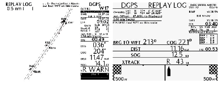
It also produces information such as course over-the-ground (COG), speed over-the-ground, and distance from the centre of the channel. Satellite information, DGPS correction, and other system health diagnostics can also be displayed. This system was designed specifically as a pilotage aid and was being used on a test basis during the voyage from Les Escoumins pilotage station. Although the pilot glanced from time to time at this equipment, he was using the ship's radars and visual leading lights, in the usual fashion, to conduct the Alcor up the river.
A 1.9.2 Steering Gear
The Alcor was equipped with a four ram Mitsubishi electro-hydraulic steering gear (Rapson Slide type). There are two Mitsubishi Janney pump units to pump hydraulic oil, each driven by a 15 kilowatt, 1800 r/min electric motor. One or both pumps can be put on line when operating the steering gear. With one pump operating, 65° of rudder movement takes an average of 27 seconds; with both pumps, it takes an average of 21 seconds. The gear can be operated by a local trick wheel in the steering gear flat or from the helm unit on the bridge.
The steering gear was designed to produce a torque of 50 tonne/metres (t/m) at the maximum working pressure (170 kg/cm2).
A 1.9.3 Bridge Helm Unit
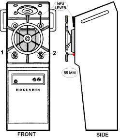
The Alcor was fitted with a Hokushin steering control system, model PT-7J2. This system, fitted during construction of the vessel and approved by the classification society, includes an all-electric helm unit, incorporating hand-steering capabilities and autopilot functions. One switch selects either autopilot or hand steering and is located on the lower left-hand side of the steering unit front piece (see Figure 3, front view, switch No 1).Footnote 10
If hand steering is selected on switch No 1, a second, three-way SMS switch (No 2), labelled "Pilot Main" on this unit, permits the choice of OFF, HAND, or NFU. Switch No 2 is located on the lower right-hand side of the steering unit front piece, 55 mm behind the spokes of the steering wheel.
The detent torque required to turn the SMS switch was found to be 0.6 newton/metre (Nm).Footnote 11 No quantitative norm or regulation governing detent torque is known to exist for this type of switch in this type of application.
When the SMS switch is in the OFF position, turning the wheel or moving the NFU lever one way or the other does not impart a signal to the steering gear. With this switch in the HAND position, a signal is sent when the wheel is turned to the left or to the right - turning the wheel two full rotations is equivalent to 35° rudder angle. When the switch is in the NFU position, the spring-loaded NFU lever must be held to one side or the other for a signal to be sent to the steering gear. Turning the wheel when the switch is in the NFU position - an independent mode - does not impart a signal to the steering gear.
Steering commands from the bridge helm unit are transmitted through one of two independent wiring paths, each connected to its own solenoid valve (autopilot directional valve) at the steering gear. Signals are also amplified by one of two independent amplification arrangements. Selections are made at the bridge helm unit as to "power unit 1" or "power unit 2" (wiring path), and/or "amp 1" or "amp 2" (amplification unit). This arrangement can be interswitched in any combination and serves to provide backup in the event of any one of the systems failing. Both these switches were reported to have been in the No. 1 position at the time of the grounding.
A 1.10 Tests and Surveys of Steering Gear and Steering Control System
At approximately 1700 on 09 November 1999, TC inspectors boarded the Alcor to assess the situation and verify the seaworthiness of the vessel. Steering gear failure had been initially reported, so the inspectors surveyed the steering gear upon their arrival. Since visual inspection revealed no anomalies, inspectors carried out operational tests from the wheelhouse and the steering gear flat. The steering control system and steering gear performed without any apparent fault, although port-to-starboard operation was marginally longer than starboard-to-port operation. This may have been attributable to obstructions on the river bottom at this time, as the vessel was aground. Similar surveys and tests were carried out by TSB on 20 November 1999. No anomalies were found, and times were similar for all directions of operation.
On 15 December 1999, a complete verification of the electric components of the steering control system, including the steering station, wiring connections to the steering gear, and electrical components at the steering gear were carried out. No anomalies were found with the electrical system.
On 16 December 1999, certain hydraulic components of the steering gear (the steering pumps, relief valves and directional valves) were bench tested at a shore facility. Results showed that the steering pumps, fitted at the time of construction, had a flow capacity approximately 17% below original specifications. Solenoid valves were found to be operating normally, although one of these valves, "power unit 2", had an infiltration of hydraulic oil within its casing. The starboard relief valve was found to be leaking at low pressure and approximate crack pressure was found to be 124.14 bars (1800 pounds per square inch [psi]). The port relief valve was operating at 158.6 bars (2300 psi). The design pressure for these valves is 168.9 bars (2450 psi).
The hydraulic components that were left in place on board the Alcor, such as the rams, connecting piping, hydraulic oil reservoir and various valves, were surveyed. The main rams showed normal wear and scoring and the packing glands were seen to be leaking. The hydraulic oil in use at the time was tested and found to be more viscous than the manufacturer's recommendation.Footnote 12 The oil contained trace elements of copper, iron and lead, indicating wear in the system components. All other components were found to be normal.
Close examination of the steering gear arrangement and rudder angle indicator mechanism revealed no anomalies. When "power system 1" was selected, there was no difference between actual rudder angle and rudder command. When "power system 2" was selected, there was an approximate two to three degree difference between actual rudder angle and rudder angle command in the wheelhouse, such that when the wheel was in the midship position, the rudder was approximately two degrees to starboard.
A 1.11 Pilotage Licences - Laurentian Pilotage Authority
A 1.11.1 Current Structure
The Laurentian Pilotage Authority (LPA) is divided into four districts: District 1-1 (Port of Montréal), District 1 (Montréal to Trois-Rivières and Trois-Rivières to Québec), District 2 (Québec to Les Escoumins and Saguenay River) and District 3 (all other areas). Districts 1-1, 1, and 2 are compulsory pilotage areas; District 3 is non-compulsory.
Within each district, there are different levels of pilotage licences (Class A through Class D) based on criteria prescribed in LPA regulations. Limiting factors that define the different classes are the size of the vessel piloted and time worked at a particular level (with a minimum number of pilotage assignments). For districts 1-1 and 1, size limits of the vessels for various classes are determined by length of the vessel piloted. In District 2, it is deadweight tonnage of the vessel that defines maximum size of the vessel for a given class. Table 3 outlines these factors. Class D licences are for apprentice pilots in all districts and for any size ship in the presence of a licensed pilot.
| District | Licence | Limiting Factors | |
|---|---|---|---|
| Size of Vessel | Time to be served in class before moving to higher class | ||
| 1-1 | Class A | Ship of any size | - |
| Class B | Ship not exceeding 210 m in length | 1 year | |
| 1 | Class A | Ship of any size | - |
| Class B | In the first year, any ship not exceeding 195 m in length In the second and subsequent years, any ship not exceeding 215 m in length | 3 years | |
| Class C | In the first six months, any ship not exceeding 165 m in length In the subsequent six months, any tanker not exceeding 165 m in length, or any other ship not exceeding 175 m in length In the second and subsequent years, any tanker not exceeding 165 m in length or any other ship not exceeding 185 m in length | 2 years | |
| 2 | Class A | Ship of any size | - |
| Class B | Ship not exceeding 50 000 DWT | 6 years | |
| Class C | Ship not exceeding 30 000 DWT | 2 years | |
A 1.11.2 Evolution of LPA Regulations Regarding Pilotage Licences
In District 2, the LPA regulations with respect to the vessel size limits has often been the result of proposals made by the Pilot Corporation.Footnote 13 These proposals are often based on a popular vote within the Corporation membership. The LPA - as the legal authority entrusted with the mandate of administering, in the interest of safety, an efficient pilotage service in these areas - can accept or reject these proposals.
Evolution of the criteria defining classes of pilotage licence in District 2, both DWT and duration worked, began in 1983. In that year, the limiting factor criteria for size of vessel was changed, by regulatory amendment, in two ways.Footnote 14 First, the net registered ton (NRT) unit of measurement was changed to DWT. Although the ratio of DWT to NRT can vary widely among vessel types, a sampling of river traffic in the St. Lawrence has shown the ratio to be somewhere between 1 and 3.5, with a typical average somewhere near 2.7. Given this, the original limits as expressed in NRT for Class B and C (10 000 and 5000, respectively), would have been loosely equivalent to 25 000 DWT and 12 500 DWT, respectively. The second change brought about by the 1983 amendments was the increase of ship sizes to 50 000 DWT for Class B and to 15 000 DWT for Class C.
In 1992, time spent as an apprentice pilot in District 2 was reduced by regulatory amendment from three years to two years, although the minimum number of pilotage assignments remained approximately the same, such that the apprentices performed as many trips in two years as previously in three.Footnote 15
In 1994, the DWT limit for Class C pilots was increased from 15 000 DWT to 20 000 DWT. The accompanying Regulatory Impact Analysis Statement for the 1994 regulatory change, as published in the Canada Gazette, Part II, states, in part:
as the number of mid-sized type vessels has decreased in recent years in that district. Therefore the amendment will permit holders of licences and Class C pilotage certificates to complete their training more effectively while under this Class.Footnote 16
In 1999, the DWT limit for Class C pilots was increased once again (from 20 000 to 30 000 DWT). The following Regulatory Impact Analysis Statement for the 1999 regulatory change, as published in the Canada Gazette, Part II, states:
The use of larger ships in these waters prompted changes to subsections 15(4) and (5) of these regulations. These provisions amend the current ship limitations for holders of Class B and C licences and pilotage certificates, based on a ship's length and deadweight tonnage. This initiative provides Class B and Class C holders with the experience of piloting more ships and larger ships which were previously piloted by more senior Class holders. In addition to enhancing the knowledge and training base for these Class B and C holders, this provision provides the Authority with greater flexibility in the dispatching of its pilots, thereby improving service efficiency, particularly in peak traffic periods.Footnote 17
All of the above-mentioned regulatory changes are summarized in Table 4.
| Class | DWT (ship not to exceed) | Years Served | ||||
|---|---|---|---|---|---|---|
| Prior to 1983 | 1983 | 1994 | 1999 | Prior to 1992 | 1992 to present | |
| Class B | approx. 25 000 (10 000 NRT) | 50 000 | 50 000 | 50 000 | 6 | 6 |
| Class C | approx. 12 500 (5000 NRT) | 15 000 | 20 000 | 30 000 | 2 | 2 |
| Class D | Ship of any size (accompanied by a licensed pilot) | 3 | 2 | |||
Minimum entry-level competency for pilots in District 2 was also increased in this period. Prior to 1980, a First Mate Home Trade, or Second Mate Foreign Going certificate was required as a minimum for District 2 pilots. A 1980 regulatory amendment made Master Home Trade or First-Mate Foreign Going certificates the minimum requirement.Footnote 18
A 1.11.3 Evolution of Service Agreements Regarding Pilotage Licences
Within District 2, where the Alcor grounded, there are subclasses for Class B and Class C licences that are defined within the service agreement between the LPA and the Pilot Corporation. The service agreement respects LPA regulations for maximum DWT and duration worked and imposes lower DWT limits for the first years worked in a given class. The evolution of service agreements and the impact these agreements have had on the application of the regulation are summarized in Table 5.
| Licence Class | Period Covered by Service Agreement | ||||||||
|---|---|---|---|---|---|---|---|---|---|
| 1983-1993 | 1993 - June 1997 |
20 July 1997 - October 1999 |
21 October 1999 - 2003 |
||||||
| Limiting Factors: Maximum DWT and Years Served | |||||||||
| DWT | Years | DWT | Years | DWT | Years | DWT | Years | DWT | Years |
| B | B-1 | 50 000 | 2 | 50 000 | 2 | 50 000 | 2 | 50 000 | 3 |
| B-2 | 35 000 | 2 | 35 000 | 2 | 40 000 | 2 | 40 000 | 3 | |
| B-3 | 25 000 | 2 | 25 000 | 2 | 30 000 | 2 | |||
| C | C-1 | 15 000 | 2 | 15 000* | 2 | 20 000 | 2 | 30 000 | 1 |
| C-2 | 20 000 | 1 | |||||||
The 2000-2003 Service Agreement reflects changes to LPA regulations that came into force on 21 October 1999. Changes include 30 000 DWT as a limit for Class C licensed pilots, up from the previous 20 000 DWT. The service agreement limits the first year worked as Class C to 20 000 DWT and then allows for the increase to 30 000 DWT in the second year worked. Also, by virtue of the service agreement, Class B-3 has been eliminated and Classes B-2 and B-1 are for three years each as opposed to the previous two years.
A 1.12 Pilotage Training
A 1.12.1 Apprenticeship Program
Pilots accepted into the program in the Laurentian Districts must undergo a two-year apprenticeship, during which they participate in pilotage of vessels in the presence of a licensed pilot. During these training trips, pilots can make written comments as to the adeptness or deficiencies observed in the apprentice's ability, but no formal guidelines exist for this process. Apprentice pilots must also undertake formal classroom instruction, in their first and second years, concerning knowledge of the district and general.htmlects of the profession, including low under-keel performance of vessels. At the end of the apprenticeship program, extensive oral and written exams are given. Vessel performance with low under-keel clearance may, or may not be, part of the series of theoretical questions asked during the exams.
LPA regulations stipulate a minimum number of pilotage assignments (113) to be made each year as an apprentice pilot, although the Pilot Corporation's training plan is more rigorous, specifying 120 trips. Harbour movages are also quantified for the major harbours of District 2 (for District 2 licences). LPA regulations do not qualify the type or size of vessel to be piloted, nor do they specify a minimum number of assignments to be made on ships with low under-keel clearance. On the other hand, the Pilot Corporation's training plan stipulates a minimum of three trips per year on vessels with draughts of 12.8 m or more. According to the Pilot Corporation, at least 25% of all pilotage assignments by apprentices are on vessels having draughts of 10 m or more. This is not a requirement, however, but a reflection of the size of vessels trading in the area.
In order to evaluate the apprentice's actual performance, the Pilot Corporation's training plan stipulates that an apprentice must make at least two trips, during the second year of training, in the company of a Pilot Corporation board member.Footnote 19 Evaluations are performed informally by observing the apprentice's pilotage skills during the trip. No formal evaluation process or tool is used during the accompanied trips and the apprentice's skill and knowledge of low under-keel clearance is not necessarily evaluated at this juncture.
A 1.12.2 Post-Apprenticeship Training
During their careers, pilots are offered additional training, including courses in bridge resource management (BRM) and ship-handling. All training deemed necessary by the Pilot Corporation is submitted to LPA for approval. Costs for training are covered off by a fixed amount allocated by LPA while the balance, if any, is assumed by the membership of the Pilot Corporation. The amount allocated for training is negotiated by the two parties and stipulated in the service contract. This amount has been unchanged since 1990. For the years 2001, 2002 and 2003, it was agreed to increase this amount to cover the costs of BRM training. BRM training has been identified as a priority and will be mandatory for all pilots by 01 January 2005.
Starting in 1972, the Pilot Corporation has been sending its pilots on a ship-handling course. Since the 1980s, this training has been a one-week course that employs working, scale model vessels that trainees manoeuvre through waterways that recreate currents, bank effect and similar phenomena. The models are used to teach practical.htmlects of ship manoeuvring. Classroom time is devoted to ship-handling theory, including subjects such as the dynamics of a vessel's pivot point.
Initially, this course was offered only to Class A pilots. Beginning in 1990, it was extended to Class B pilots. In 1993, it was enshrined in the service agreement with LPA, such that all Class B pilots would be sent on this course in the first year of their service as a Class B. As of the end of 1999, all Class A pilots in District 2 had taken the course (95% have taken it twice), as had all Class B pilots, save one. No Class C pilots had yet received this training. Because of the high cost of such training and the allocation of funds by the LPA, the Pilot Corporation could only assign a maximum of 12 participants per year to the course. If more than 12 new Class B pilots are entitled the training, participants are selected by seniority.
In other pilotage areas of Canada, candidate selection for this training is different. The Central St. Lawrence Pilot Corporation (LPA District 1) selects candidates for this training at random amongst all classes of pilots. In British Columbia, the Pacific Pilotage Authority sends all pilots on the ship-handling course during the fourth month of a six-month apprenticeship program. The Great Lakes Pilotage Authority does not, as yet, send its pilots on such training, but a recent review of training requirements has identified it as a need.
A 2.0 Analysis
A 2.1 Performance of the Steering Control and Steering Gear
A 2.1.1 Sequence of Events
According to the DGPS replay from the pilot's laptop, a decreasing trend in vessel speed had begun at 1438:10. This indicates that the turn to starboard was initiated; the drag force created by the rudder and the increased water resistance on the vessel's port side began to be felt.
A vessel making a turn with a set rudder angle will reach a maximum rate of turn for that angle and then remain stable at that rate until the rudder angle is changed. The time that the rate of turn remains stable can be considered a close approximation to the time the rudder remains at the set angle. Simulations conducted using maximum rudder angle at varying time intervals illustrate this result.Footnote 20
The rate of change of COG was analysed via data from the DGPS replay. Since wind and current were near constant, and the time interval brief, the rate of change of COG can be used here as a close analogy for rate of turn. This information shows a maximum rate of change to starboard was maintained for a very short time (15 to 20 seconds) before it decreased quickly to near zero. These data corroborate the sequence of events as reconstructed from observations of those on the bridge, in the engine control room and in the steering flat - in particular, the 15- to 20-second interval during which the helm did not respond and remained hard-to-starboard, after which the helm was placed at midships and the rudder responded.
The data collected thus indicate that the rudder remained to starboard, at varying angles, for approximately 40 to 50 seconds, of which 20 seconds were at the hard-to-starboard position (35°) and after which it went to midships. The rudder did not respond to helm orders for about 15 to 20 seconds.
A 2.1.2 Accidental Deactivation of the Ship's Wheel
The ship's records show no intermittent or chronic problems or any unusual maintenance on the steering gear or its components. Extensive testing of all electrical components (steering station, wiring and components at the steering gear), on-board inspections and extensive bench testing of the hydraulic components of the steering gear were carried out; no malfunction was apparent. Although the flow capacity of the steering gear's hydraulic pumps had diminished about 17% over 22 years of service, the steering gear could still produce a theoretical torque in the range of 40 t/m. Flow rates measured during bench testing would produce a torque of 32 t/m at an operating pressure of 103.5 bar. This would have been more than sufficient to execute rudder movements with the vessel making 12 knots through the water. The calculated torque necessary to hold or move the rudder under these conditions would have been about 12.65 t/m.
No intermittent failure was reproducible during extensive operational tests after the grounding, and there was no report or record of any intermittent failure in the past. It is unlikely that there was an intermittent failure of the steering gear at this exact time, and for this duration. Given the length of time the helm did not respond and the reported return of control after the OOW had toggled the SMS switch, loss of rudder control was probably due to the SMS switch being at a position other than HAND.
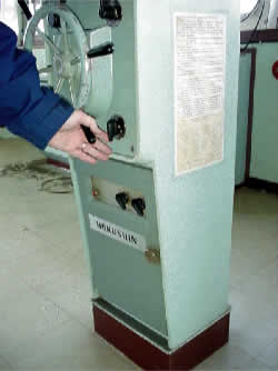
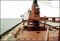
The SMS switch of the helm unit is 55 mm behind the spokes of the hand steering wheel. Simulations conducted after the accident revealed that the switch could be accidentally thrown right, to the NFU position, when the wheel was turned to the right, or left, to the OFF position, when the wheel was turned to the left.Footnote 21 With the low detent torque of 0.6 Nm, this switch was relatively easy to turn by simply leaving the fingers of the hand extended while turning the wheel (see photograph 1). The location and orientation of this switch were such that accidental activation was possible. There was no protective barrier or alarm for this switch.
Accidents in various transportation modes have been attributed to a less-than-adequate location and/or design of safety-significant controls.Footnote 22 Control actuators should be designed and located so they are not susceptible to accidental activation. Methods to reduce the likelihood of accidental activation include:
- locate and orient the control actuator so that unwanted activation is unlikely;
- provide sufficient control resistance (detent torque) to prevent unintentional movements;
- require complex motions for control activation such as an interlock or rotary motion; and
- isolate controls or provide some sort of physical barrier.Footnote 23
Many models of ship helm units incorporate safety features, such as alarms or guards on the SMS switch. These switches are also in a location and orientation that reduce accidental activation. Also, the detent torque on many models has been observed to be considerably higher than it was on the Alcor.
It is not possible to determine with certainty whether the SMS switch was moved to the NFU position (while the pilot was turning the wheel to the right) or to the OFF position (while the pilot was turning the wheel to the left). Either event would have resulted in wheel deactivation. The movement of the switch from HAND to either one of these locations would explain the brief lack of response from the rudder just prior to the grounding.
A 2.2 Ship-handling and Pilotage Experience
The vessel's head was coming to starboard even before the pilot assumed the helm. Even at a rate of turn of one third of a degree per second (a very slow turn), the 9.5° starboard alteration would not have taken more than 30 seconds, leaving two and a half minutes to position the vessel to the starboard side of the channel before meeting the downbound vessel. Instead of letting the vessel react in the time required, the pilot attempted a hard-over/hard-over counter-rudder manoeuvre.
The Alcor had a static depth of water to draught ratio (Dw/d) of 1.67 while off buoy K-108. If squat is considered, this ratio approaches 1.5. Since becoming a Class C, the pilot's experience on vessels (other than the Alcor) with reduced under-keel clearance, and thus with reduced Dw/d ratios, was very limited.
A ship can experience shallow water effect when the depth of water is less than twice the draught.Footnote 24 Shallow water effect becomes significant when the ratio of Dw/d is equal to 1.5. When this ratio is 1.2 or less, full shallow water effect is felt.Footnote 25 Full shallow water effect can double a vessel's deepwater turning diameter.Footnote 26
From Les Escoumins pilot station to Cap Gribane, the channel is wide and deep and vessels there display normal, deepwater manoeuvring characteristics. In the Traverse du Nord, however, the channel narrows to 305 m and is shallower. Additionally, at buoy K-108, the channel is dredged to keep the minimum depth at 12.5 m, and the 10 m depth contour is close to either side of the channel. In contrast, at the other course alteration in the Traverse du Nord, the channel is deeper and the deep water extends well beyond the channel limits.
The Alcor would have experienced the following effects and forces during the starboard turn at buoy K-108:
- shallow water effect - an increased resistance on the port side abaft the pivot point and the shifting aft of the pivot point due to increased resistance forward and on the port bow due to the low Dw/d ratio of 1.67 (this ratio is further reduced, to 1.5, if squat is considered);Footnote 27
- approximately 0.89 m of sinkage due to squat - being a large, full-bodied vessel, the squat tends to be more by the bow than by the stern, thereby adding to the 7 cm static forward trim, further decreasing rudder efficiency; and
- a tendency to go bodily to starboard due to a two to three knot following current, approximately 75° abaft the port beam.
The cumulative effects of the above would reduce rudder effectiveness and would account for the "sluggish" behaviour and resistance to the starboard course alteration at this point. Although the helmsman executed all helm orders correctly and without hesitation, the pilot opted to assume the helm himself at this juncture. Given the developing situation, the presence of another vessel 1.5 nm away, and the actions of the pilot at this time, this action suggests that the pilot felt pressure to get the Alcor turned, to remain on the starboard side of the channel. This is further reflected in the pilot applying full helm for a course alteration of 9.5°.
Efficient and effective ship-handling requires thinking "ahead of your ship" so the vessel reacts to helm and engine orders, and not to make helm and engine orders as a function of the ship's movement. Additionally, as a vessel's DWT increases, so does its momentum, which decreases its ease of handling, especially in confined waters with low under-keel clearance. The larger the ship, the longer she takes to respond to helm and engines; the more judgements must be based on advance knowledge and not on observation alone.Footnote 28 The pilot's actions suggest that he did not fully appreciate or anticipate the various adverse effects on the vessel's manoeuvrability due to the low Dw/d ratio, squat, and following current.
A 2.3 Pilotage: Training, Experience and Risk-based Methodology
As the size of merchant ships increased throughout the 1970s and 1980s, both LPA and the Pilot Corporation recognized the need to increase the vessel size limits at which the Class B and Class C pilots could work, to meet changes in demand for pilotage services. Changes were essential to provide LPA with flexibility to dispatch the proper class of pilot and to fully employ the group of less senior pilots as the number of smaller ships dwindled. Toward that end, LPA and the Pilot Corporation elected to use service agreement changes to supplement regulatory change. However, none of these changes (which directly affect safety) were subjected to a formal risk assessment.
A typical risk assessment methodology takes into consideration, among others, the following:
- identify the problem and associated risk factors, and develop an information base related to the risk factors;
- form a risk management team to carry out the risk assessment;
- identify and consult with all interested parties and determine their risk concerns;
- analyse risk scenarios and their frequency, consequences, and cost implications, as well as interested parties' acceptance of risk;
- identify risk control options and their effectiveness and cost implications;
- assess interested parties' acceptance of proposed actions and residual risks; and
- establish a process to monitor the chosen action.
The need for such an approach has been identified in the 1999 Canadian Transportation Agency (CTA) Pilotage Review Report, and is reflected in recommendation 1, dealing with designated compulsory pilotage areas.
As a result of changes to the licence class required for a particular vessel size, the required pilotage experience (excluding apprenticeship) of a licensed pilot on a ship of more than 25 000 DWT (such as the Alcor, at 27 536 DWT) has diminished as follows:
| Period | Prior to 1983 | 1983 - June 1997 | July 1997 - October 1999 | Since October 1999 |
|---|---|---|---|---|
| Experience | 8 | 4 | 2 | 1 |
Under the current regulation / service agreement combination, a pilot is permitted to work on ships up to 30 000 DWT one year after becoming a pilot. This level of experience (excluding apprenticeship) is one quarter of the level of experience that was required on vessels greater than 25 000 DWT before July 1997.
A 2.3.1 Pilotage Training, Experience and Performance Measurement
A 2.3.1.1 Training Requirement
The two-year pilot apprenticeship program for District 2 covers technical and local knowledge.htmlects of the profession and provides hands-on training. Apprentice pilots may select the vessels they wish to work on and are encouraged to choose as wide a variety of vessels as possible. Experience on deep draught vessels during apprenticeship is required (per the pilot corporation's training plan) to the extent of three trips per year on vessels with draughts of 12.8 m or more. However, this accounts for only 2.5% of the specified number of compulsory trips per year. Although information obtained from the pilot corporation and the pilotage authority indicates a higher level of exposure to deep draught vessels than these minimum requirements, no formal system is in place to measure and evaluate the apprentice's capacity on these vessels, and in particular the candidate's ability to handle vessels having low under-keel clearance.
With changes in the pilot licensing regime, pilots are now required to handle larger tonnage vessels earlier in their pilotage career without a requirement to gain experience on these vessels and/or through a specialized ship-handling course using manned model training.Footnote 29
A 2.3.1.2 Ship-handling Experience and Training
Ship-handling skills are acquired through a combination of formal training and practical experience. The pilot must acquire sufficient knowledge to continually evaluate the navigational situation in order to make decisions and/or take appropriate measures to safely pilot the vessel.
Formal training reinforces the knowledge of basic concepts. However, emphasis on practical experience is paramount, as it provides an opportunity for a pilot to apply those concepts in varying operational circumstances.
In the past, the longer time spent on smaller vessels allowed progressive accumulation of ship-handling experience as a pilot progressed through his/her career path. A small vessel, being more readily recovered from a ship-handling error, can add to the experience base of a pilot while the potential for adverse consequences is minimized. This slower progression to larger vessels provided pilots with an opportunity to deepen their experience base before serving on larger vessels.
Realizing that change was necessary, an initiative to adjust to larger ships navigating the St. Lawrence saw the minimum level of certification for pilotage candidates raised to Master Home Trade (or First Mate Foreign Going). While it is recognized that there is an increase in sea time for persons seeking these certificates, this does not assure that a candidate will be more skilful in ship-handling.
Specialized ship-handling courses, designed to accelerate the experience base of pilots, can be used to supplement the knowledge gained through apprenticeship. If given early enough, such a course would prepare pilots to handle larger ships at each stage of their license progression.
A 2.3.1.3 Current Practice
Recent reductions in the experience base for licensed pilots on 25 000 to 30 000 DWT vessels have not been offset by earlier training (such as the ship-handling course) or clearly defined criteria in the apprenticeship program that places a greater emphasis on vessels with low under-keel clearance. Further, under the current regime, pilots progress from one class to another, based strictly on completion of a minimum number of assignments in the required time. The ability to handle larger vessels is not qualitatively assessed at each or any stage.
Current practice within District 2 calls for all new Class B pilots to be sent for ship-handling training during their first year. With LPA regulatory/ service agreement changes, the C-1 class is now the equivalent of the old B-3 class. These pilots have less experience than their B-3 predecessors but they are not offered the same training until they become Class B pilots. Given that pilots are required to work on larger vessels earlier than before, the extension of such training to the C-1 pilots could help increase the training/experience and better prepare pilots for larger vessels.
A 2.3.1.4 Pilotage and Safety
The primary purpose of pilotage is safety. Compulsory pilotage areas are established for the benefit of the community - to protect the environment and port infrastructure from marine accidents. There is an expectation that a pilot's performance and operational procedures are of a standard that is internationally recognized and accepted. The Board, recognizing the need to maintain the highest practical safety standard for vessels operating in Canadian pilotage waters, recommended that pilotage authorities develop and implement a safety management quality assurance system.Footnote 30 The Minister of Transport accepted the recommendation and tasked the pilotage authorities to develop a pilot quality assurance system. This has also been addressed in recommendation 9 of the 1999 CTA report, which reads, in part:
that the pilotage authorities be required to develop and implement a fair and reasonable system for assessing pilots' competence and quality of service, after consultation with interested parties. This assessment process should take place regularly and not less than every five years.
Pilots working on larger ships earlier in their careers has increased the need for an effective quality assurance program. Given the reduced experience base, a competency-based training and evaluation program will permit objective evaluation of a pilot's abilities to safely navigate a vessel.
A 3.0 Findings
A 3.1 Findings as to Causes and Contributing Factors
- The combined effects of squat, shallow water effect and a following current, in conjunction with the vessel's speed and the low under-keel clearance, contributed to the sluggish steering behaviour of the Alcor off buoy K-108.
- The pilot's experience and training was such that he did not fully appreciate or anticipate the undermining effects of low under-keel clearance on the vessel's performance. By assuming the helm and employing hard-over wheel for a minor course alteration, the pilot, perceiving an emergency situation where none existed prior to his assuming the helm, set in motion the chain of events that resulted in the grounding.
- The location, orientation, and low detent torque of the steering mode selector switch, and the absence of a mechanical guard, probably allowed for the accidental deactivation of the ship's wheel, which would account for the brief lack of response from the rudder (15 to 20 seconds) just prior to the grounding. An alarm would have permitted the movement of this switch to be noticed by the navigation team at this critical time.
A 3.2 Findings Related to Risks
- The LPA allowed incremental regulatory and service agreement changes to go forward without the benefit of a formal risk assessment. This permitted handling of larger vessels by pilots who may not have been fully prepared to do so.
- The current apprenticeship and post-apprenticeship training program does not qualitatively evaluate a candidate's ability to handle larger vessels or vessels with low under-keel clearance.
A 3.3 Other Findings
- Flow capacity of the steering gear's hydraulic pumps was found to be diminished by approximately 17%, compared to original specifications, but was sufficient to execute rudder movements.
Part B - Salvage
<a id="B1"></a>B 1.0 Factual Information
B 1.1 Preparations for the First Refloating Effort
B 1.1.1 Loading and Trim
The Alcor loaded pelletized foundry clinker at Le Palito, Venezuela, on 25 October 1999. The vessel was repositioned several times during the loading operation to provide for the clear flow of cargo from the loading facility into each cargo hold. This ensured satisfactory distribution, loading rates and hull stresses. The final distribution of cargo was such that holds 1, 2, 4, and 5 were partially filled, while hold 3 remained empty.
The distribution of cargo was similar to several of the typical loading conditions included in the vessel's approved stability and strength booklet (Loading Manual). Total cargo deadweight was slightly less than that of the nearest comparable loading condition (in which hold 3 also remained empty). The lighter cargo deadweight resulted in lower sheer forces and still water bending moments (SWBM) imposed on the hull; on departure, the SWBM was approximately 40% of the approved maximum. Once loaded, the recorded draughts were 9.77 m forward and 9.86 m aft.
B 1.2 First Refloating Effort
As previously mentioned (Section A 1.2.2), one tug was ordered some 1.5 hours after the initial grounding, and it arrived on scene at 1930, 09 November 1999. After high tide, refloating the vessel was not possible, and one tug was found to be insufficient to the task.
Due to the short period before the next high tide, the unavailability of transhipment vessels, and water depth restrictions around the Alcor, no lightering operations were planned. The Alcor did not have self-unloading capabilities, so sacrificing cargo to reduce draught was not an option.
Early on the morning of 10 November 1999, loud reverberations were heard throughout the ship. Small cracks were discovered on the main deck, on the starboard side at frame 120, and on the port side between frames 95 and 100. The master, TC officials, and the pilot agreed that the Alcor should be refloated as quickly as possible, as huge strains were being imposed on the structure with each low tide. The river bottom forward was approximately two metres lower than that aft of amidships.
By the evening of 10 November 1999, some 28 hours after the grounding, a salvage effort was made with four tugs. A Lloyd's Open Form was agreed to only just before the refloating manoeuvre. By 1745, hopper tanks 2 and 3 on the port side and hopper tank 3 on the starboard side had been pressed with compressed air. Although the pilot had suggested the manoeuvre proceed to the north (moving ahead), the plan the salvors used was to pull the Alcor astern and into deeper water in a southeasterly direction. By 1755, the four tugs were in position. Three unsecured tugs on the port side pushed to keep the vessel from riding up higher onto the bank with the flood tide, while one, secured astern, pulled in a southeasterly direction.
By 1815, the Alcor was pivoting about her centre, approximately between the headings of 285° T and 055° T. At 1835, one of the three pushing tugs was sent forward, secured, and pulled in concert with the stern tug. At approximately 1900, nine minutes after the measured high tide of 5.96 m and with the flood current decreasing in strength but still in a southwesterly direction (220° T), the Alcor began to move astern under tow and her own power.
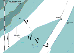
Soon after the Alcor began to move astern, the tugs stopped assisting under the salvage master's instructions, while the engine of the Alcor was kept moving astern for approximately two minutes. During this time, the vessel's heading was fairly constant at about 285° T. Soon after the vessel started astern, the salvage master inquired of the pilot, who was at one of the radars, if the vessel was in safe water. When the pilot responded in the affirmative, the salvage master put the engine of the Alcor to stop; the salvage master had not yet handed the con over to the pilot. Shortly after this, the ship stopped moving astern. The engine was again put to full astern by the salvage master and the tugs resumed their assistance, but to no avail. The Alcor had moved some 2.8 cables to the southeast and had grounded for a second time at position 47°03′08″ N, 070°45′12″ W (see Figure 5).
By 1945, the falling tide had dropped by about 0.5 m. Despite the continuous effort of the tugs, the vessel remained immobile. A decision was taken to suspend the salvage operation until the following high tide. At about 2200 that evening, the pilot requested a relief break from the pilotage dispatch centre in Québec, some 31 hours after the initial grounding.
B 1.3 Hull Failure
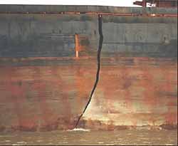
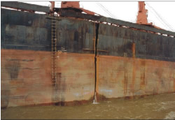
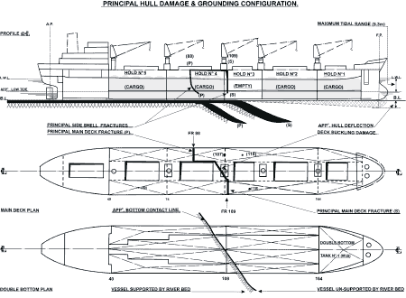
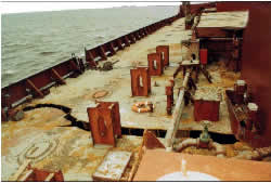
At approximately 0015 on 11 November 1999, a loud reverberation was heard throughout the ship. A large fracture had developed transversely across the main deck, near frame 110 on the starboard side, through the No 4 hatch coaming, and across to frame 87 on the port side. The fracture extended down both sides and stopped just short of the hopper tanks. Holds 3 and 4 were opened to the sea and the fracture on the main deck was as wide as 0.52 m in some places (see photographs 2, 3, and 4).
For safety reasons, all but a skeleton crew were evacuated from the vessel. The salvage company abandoned the Lloyd's Open Form salvage agreement and relinquished control of the vessel. Later that day, the owners of the Alcor were served a request of intention on behalf of both the Canadian Coast Guard (CCG) and TC under the auspices of the Navigable Waters, Protection Act and the Canada Shipping Act, respectively. The owners were instructed to present a plan for removal of the vessel in short order or risk loss of control of the process.
Time was of the essence, as winter ice conditions could aggravate the salvage operation and further compromise the vessel's structural integrity. First ice formation was predicted for as early as 13 December 1999.
B 1.4 Second Refloating Effort
B 1.4.1 Preparations
On 19 November 1999, a second salvage company was selected.
The refloating effort was scheduled for the evening high tide of 07 December 1999. As this date approached, unfavourable winds were predicted for both December 06 and 07. The refloating was advanced to the afternoon high tide of 05 December 1999. By then, preparatory work for refloating had been completed, which included an underwater survey of the hull, ballasting down, strengthening in way of the fracture, removal of unnecessary fuels, lightering of cargo (approximately 11 200 t had been taken off), and a detailed hydrographic survey of the grounding area. Three special buoys had been placed nearby to indicate the deep water limits in the vicinity of the vessel.
Closing the Traverse du Nord during the refloating and transit of the Alcor through this section of the river had been discussed informally by TC, CCG, and salvors. However, no explicit plan or directive was in place to execute this action.
On the morning of 05 December 1999, the salvage master briefed officials from CCG and TC, as well as the refloating team, including the tug masters, and the owners' representatives, on the planned manoeuvre. The plan was to move the vessel forward once afloat, and then turn her stern to starboard in order to back her out of the confined area bordered by shoals on either side. Once in safe water, the con was to be passed to a river pilot for passage to Québec. The four river pilots scheduled for the operation, two for the Alcor and two for the lead tug, were not present at this time, but were briefed upon their arrival on board a few hours later. Although no specific location was indicated at which the hand-over from salvage master to pilot was to take place, the pilots were informed that they would be handed the con once the vessel was safely in the channel.
B 1.4.2 Refloating Manoeuvre
The Alcor had come afloat by 1515 and two unsecured tugs were used on the port side to keep the vessel on station. One tug had been secured forward and another secured aft. At this time, the refloating team, TC, and CCG conducted a survey to assess the structural integrity of the vessel before moving it into deeper water. The gyro compass was now unreliable and could not be used. The magnetic compass was also unreliable, due to the considerable amount of reinforcing steel brought on board to strengthen the broken vessel. Although the vessel's radars were operational, they had to be used in the ship's head-up configuration due to the unreliable gyro input.
In the wheelhouse at this time, apart from TC and CCG officials who were observing the operation, the bridge team consisted of the salvage master, a salvage captain (acting as master), and the two river pilots. There was no dedicated helmsman or OOW.
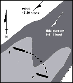
At approximately 1540, under her own power and with the help of the tugs fore and aft, the Alcor was first moved forward (see Figure 6, position 1) and then pivoted, the stern moving to starboard, until the vessel was on an approximate heading of 215°T, parallel with the shoals on either side (see Figure 6, position 2). Once in this orientation, sternway was put on using the stern tug and the engine of the Alcor. The operation was executed as initially planned.
At approximately 1550, with the bow of the Alcor just past the special buoy to port (see Figure 7, position 3), the salvage master asked if one of the pilots was ready to assume conduct of the vessel. The first pilot replied in the affirmative and took the con, asking the stern tug to pull in the direction of the K-108. The second pilot was using one of the radars and the salvage captain the other. Although visibility had been good before the refloating, it had now diminished to approximately 0.5 nm, and even less at times.
The Alcorwas still going astern when the salvage captain, who was also plotting positions on the chart, declared that the vessel was coming dangerously close to the shoal named "Le Banc de Sable", 1.2 nm south-southwest of Cap Tourmente. Although the second pilot, who was verifying the vessel's position on the radar, was sure the vessel still had plenty of sea room, the first pilot, who had the con, ordered the stern tug to stop pulling and ordered ahead engine on the Alcor. The salvage master put the engine-room telegraph to half ahead (see Figure 7, position 4).
B 1.4.3 Change in Plans
During the astern manoeuvre, the Alcor had inadvertently been allowed to turn to port, from an initial heading of 215° T to somewhere between 140° T and 150° T. There are differing views as to why this happened, but it is generally accepted that there was an unwanted pulling in the forward tug's towline as the astern manoeuvre was carried out. Ideally, this line would have remained slack throughout the astern manoeuvre. Later, with ahead thrust from the Alcor and the forward tug now pulling, the Alcor stopped moving astern and began to move forward. Shortly thereafter, at approximately 1615, out of the mist ahead and to starboard, the buoy SB3 became visible from the wheelhouse of the Alcor (see Figure 7, position 5). The second pilot, who had been assisting, became more assertive in the absence of any orders from the first pilot. He ordered the lead tug to pull the Alcor in the direction of K-108, in order to distance the vessel from the shoal water to starboard. This action further moved the bow of the Alcor to port, to a heading of between 110° T and 100° T as the vessel entered the channel (see Figure 7, position 6).
As she came into the channel, the Alcor was now headed more downriver than upriver. The second pilot, who had by now assumed de facto con of the vessel, decided to continue downriver and turn at Sault-au-Cochon, where more sea room was available to manoeuvre. By 1617, the vessel was straightened out in the channel and headed downriver.
B 1.5 Damage Subsequent to the First Refloating Effort
During the early morning hours of 10 November 1999, near low tide, small cracks on the main deck were observed and recorded by the crew: near frame 120 on the starboard side and between frames 95 and 100 on the port side. The river bottom at this initial grounding position was such that the aft 40% of the vessel was in approximately four metres of water while the fore part of the vessel was on a gradual slope to deeper water with the bow in about six metres of water.Footnote 31
Orientation of the vessel in the second and final grounding position, shortly after 1900 on 10 November 1999, and its "footprint" on the riverbed were such that the bottom shell plating aft of midships was in approximately 2.5 m of water. This part of the vessel thus maintained effective bearing contact throughout the tidal cycles. The forward half of the vessel was on a gradual slope, with the bow in about five metres of water. The buoyant support of the forward half of the grounded vessel fluctuated as the water level rose and fell with the tides. The maximum tidal range prior to the main structural failure of the Alcor was 5.31 m, which was slightly more than half of her original forward draught when afloat.
Once settled in the final grounding position on 10 November 1999, conditions that created very high bending moments and tensile stresses in the upper members of the hull girder included:
- a large reduction of buoyant support during the low tides,
- a loss of intact hull buoyancy due to flooding of breached hopper ballast tanks 2 and 3 (P), and 3 (S), and
- a deadweight of cargo in holds 1 and 2 in the unsupported forward end of the vessel.
The SWBM near the mid-length of the hull was much greater than the approved maximum SWBM related to the vessel when free floating, and eventually exceeded that which the main deck structure of the grounded vessel could withstand.
Tensile stress concentrations at minor discontinuities in the upper members of the hull girder initiated brittle fractures in the main deck plating that subsequently propagated across the deck, into the deck longitudinals, then through the sheer strake and gunwale, finally propagating down the side shell plating.
Principal fractures in the port and starboard side shell plating breached the watertight integrity of cargo holds 3 and 4 and upper wing water ballast tanks 2 (S) and 3 (P). The width of the fractures across the main deck plating near midships widened to approximately 0.52 m.
The longitudinal integrity of the hull was only maintained by the bottom shell plating, the inner bottom tank top plating, and the internal double bottom structure. These lower members of the hull girder were subjected to compressive stress loading and remained intact, collectively acting in the manner of a large hinge.
B 1.6 Damage to the Environment
The grounding was within 0.5 nm of a bird sanctuary on the banks of the St. Lawrence River. Also, the area is the natural habitat for several species of duck. Approximately 25 t of clinker spilled out of holds 3 and 4 into the St. Lawrence River.
Clinker is not considered a marine pollutantFootnote 32 and the spill was found to pose no risk to the bird or fish habitat. No heavy fuel, diesel or other marine pollutant was released into the environment subsequent to either the grounding or the rupture of the ship's structure.
B 1.7 Weather, Current and Tide
On the evening of 10 November 1999, at the time of the first refloating effort, winds were 15 to 20 knots from the northeast. Visibility was at times reduced by snow, but on the whole remained good. The tidal current at 1900 was in a southwesterly direction, setting approximately 220° T at between 0.5 and 1 knot.
On 05 December 1999, during the successful refloating, visibility was reduced at times to less than a one nautical mile due to mist, particularly during the actual refloating manoeuvres between 1530 and 1630, where at times it was reduced to less than 0.2 nm. Once the Alcor was in the channel and underway, visibility was reported as good. At 1600, as the vessel was moved into the channel, the tidal current was setting approximately 220° T at between 0.5 and 1 knot. Winds were calm at this time.
B 1.8 Governmental Infrastructure
The waters in question are within VTS jurisdiction. The VTS mandate, other than communications, is generally limited to traffic advisories and information. Under special circumstances, VTS can direct traffic. (See section C 1.5 of this report for details on traffic direction.)
Another division of CCG was quickly involved in the Alcor incident: the Environmental Response Division of the regional Coast Guard / Marine Programs Directorate. As per their mandate, they monitored the situation for environmental considerations.
Transport Canada Marine Safety (TCMS) was active during the period that the Alcor was aground. TCMS surveyors were aboard the vessel within hours of the grounding. After the hull fracture, they remained on board on a continuous basis to monitor the vessel's condition. Once the second refloating effort was underway, they re-evaluated the structural integrity of the vessel before allowing the transit to Québec.
The Navigable Waters Protection Act provides the Minister with the necessary powers to remove a stranded vessel if the difficulty or danger continues for more than 24 hours.Footnote 33
B 1.9 Pilot Relief (District 2)
For District 2, paragraph 35 of the LPA regulations stipulates that two pilots are assigned to a vessel when any one of the following conditions are met:
- the ship is likely to be under way for more than 11 consecutive hours in that district;
- on a ship in excess of 74 999 DWT;
- on a tanker of 40 000 DWT or more;
- on a passenger ship of more than 100 m in length, or
- on any ship during winter navigation.
The requirement helps reduce risk in two ways. First, for long assignments, the two-pilot requirement acts as a fatigue countermeasure. Each pilot will work a mutually-agreed duration, and is then relieved by the second pilot, and vice versa. Second, for particular vessels where the potential severity of consequences has been seen to justify using a team approach, the requirement serves to eliminate single-point failure. In these instances, although each pilot works in turn for the majority of the voyage, a team approach is adopted for passage of strategic areas such as the Traverse du Nord.
There are no written guidelines or work procedures, nor is it specified in the regulations when or if the two pilots must work as a team; this is left up to their discretion. Additionally, there are no set criteria established for pilot assistance or relief in emergency situations when one pilot is on board. Under these circumstances, the current LPA and Pilot Corporation procedures place the onus on the pilot involved in the occurrence to make a decision as to his/her relief.
B 1.10 International Safety Management Code Procedures
The safety management system for both vessel and management was audited by Russian Maritime Register of Shipping, and found to be in accordance with the requirements of the ISM Code. The vessel's Safety Management Certificate was valid until April 2003; the managers' Document of Compliance was valid until March 2003.
Section 8 (Emergency Preparedness) of the ISM Code specifies the following:
- The company (manager) should establish procedures to identify, describe and respond to potential emergency actions.
- The company should establish programmes for drills and exercises to prepare for emergency actions.
- The safety management system should provide for measures ensuring that the company's organization can respond at any time to hazards, accidents and emergency situations involving its ships.
B 1.10.1 Vessel Procedures (Owners/Operators)
Emergency preparedness procedures were contained in the vessel's shipboard operations manual (section 6of volume II). Chapter 2 of this section contained advice on casualties including, among others, stranding, steering gear failure, flooding, salvage, and hull failure. Appendix "Q" (Salvage) of the manual also states:
In most cases, where time and circumstances permit, the owners together with the master will agree terms with the salvors on which salvage services will be rendered with the authority of other parties who have interest in the vessel and may benefit from salvage services. Therefore in the event salvage services are required it is important that the master informs the company as soon as [the] casualty occurs to prevent salvage services becoming more urgent and consequently more expensive.
However, in cases of absolute urgency, the master himself may negotiate the terms of the salvage agreement with the salvors, normally Lloyds Open form. It must be stressed that the master only has authority to reach an agreement in cases where the vessel and the cargo onboard are in imminent danger and there is no reasonable opportunity to contact owners and cargo owners and any other party with an interest in the vessel who will benefit from the salvage services in order to obtain their authority.
B 2.0 Analysis
B 2.1 Contingency Plans and Risk Assessment
In the hours following the grounding, the onus to make the right decisions as to refloating was on the master, with the assistance of the pilot. Because the vessel was not initially "hard aground", but still moving, attempts were made to free the vessel under her own power. Only one tug was ordered approximately 1.5 hours after the grounding, after permission was sought from the vessel's owners. Valuable time was lost, as by this time the vessel had moved higher onto the shoal with the rising tide. When the tug arrived, the tide had dropped about one metre. One tug was not sufficient to refloat the vessel and it sustained heavy damage before it could be refloated.
The company ISM Code procedures contained a generic checklist of actions to be taken in situations such as groundings and salvage. As each event occurred, the master, pilot and various governmental authorities reacted to events rather than take action based on a structured approach, such as could be procured from contingency plans or another risk management process.
Under the ISM Code, the safety management system clearly establishes that the master has overriding authority and responsibility to make decisions regarding safety and pollution prevention. In addition, the Protection and Indemnity Clubs recognize the urgency attached to emergency situations, and protect an owner against the financial consequences associated with the need for the master to make decisions without the benefit of cost estimates. In reality, however, the master is under pressure from the owners, either implicitly or explicitly, to consult with the company and keep expenses to a minimum under any circumstances. This is reflected in the master consulting the owners about tugs subsequent to the grounding of the Alcor. More often than not, time zone differences between the vessel and the owners' place of business, and language barriers that may exist between the master and owners, can make communication between them less than optimal and may be onerous for the master at a critical time. Additionally, the master is on location, and so is best suited to evaluate and make decisions regarding the quantity and quality of resources, rather than owners who may not be aware of all pertinent local factors. The master, however, does not necessarily possess in-depth knowledge of the grounding area or the resources available, and must rely on local authorities for guidance. The absence of local procedures, contingency plans or risk assessments (TC, LPA, CCG) can cause delays, and selection of appropriate resources for the task is not optimized.
A prompt refloating is critical to reduce risks to the environment and to the structural integrity of the vessel in high-risk waters, such as in the vicinity of the Traverse du Nord. The waters between Québec and the Les Escoumins pilot station can, in many ways, be considered high-risk waters. Hazards include:
- dense fog,
- strong currents,
- high winds,
- dense pleasure craft activity and whale watching during summer months,
- fewer floating aides to navigation during the winter months,
- high tidal amplitudes (as much as 7.1 m off Île-aux-Coudres),
- heavy ice formation,
- areas with low under-keel clearance, and
- deeply laden vessels that regularly transit on top of high water only -(Traverse du Nord).
In the event of a grounding, the level of risk associated with vessel and environmental damage varies from the time the vessel has grounded until the vessel is safe at her berth. Prompt summoning and dispatch of resources, concurrent with the initial attempt to refloat the vessel, is essential to maximize her chances of refloating. A pilot can be a valuable resource to the master during refloating. LPA has no structured approach to prepare pilots to help masters assess risks and make informed decisions to respond to emergencies, decisions that could have an impact on timeliness and appropriateness of resources.
CCG has a coordinated and structured emergency management approach, using a risk management model, for emergencies associated with pollution, search and rescue activities, and harbour operations. A similar approach, however, is not used for navigation-related emergencies (such as groundings) for vessels transiting narrow channels and in pilotage waters. "It is important to understand the risk profile of a port or waterway in order to establish risk management priorities...".Footnote 34 The dynamic nature of salvage operations often requires ad hoc problem solving and decision making, a situation conducive to increased error. A structured approach, therefore, provides a framework around which informed decisions can be made. Also, it helps all parties to coordinate, communicate and closely monitor the developing situation.
Legislation allows for timely action in responding to shipping emergencies. The Canada Shipping Act (CSA) permits the Minister of Fisheries and Oceans to take appropriate measures to minimize and prevent pollution damage, with no limiting time criterion.Footnote 35 The Navigable Waters Protection Act allows action to be taken by the Minister of Fisheries and Oceans if the obstruction or danger continues for more than 24 hours.Footnote 36 Given the tidal amplitudes between Les Escoumins and Québec, the latter may be too long a period under certain circumstances.
B 2.2 Factors Affecting Salvage Operations
The knowledge and experience base necessary for salvage operations and pilot/salvor interaction are both important contributing factors to the success of a salvage effort. Failed salvage efforts, where these factors have been less than adequate, have been noted.Footnote 37 A complete salvage plan includes preparation of the vessel for refloating and navigation of the vessel once afloat. LPA and the Pilot Corporation, with in-depth knowledge of local waters, are best suited to provide input regarding local navigation. Their participation in the planning and development phase would help ensure, among other things, that:
- the navigation plan is precise and complete,
- local factors critical to the success of the mission are considered during the planning phase,
- the role of all participants is clearly understood,
- the stage at which conduct of the vessel will change hands from the salvage master to the pilot is clearly identified, and
- effective use is made of all available resources and technology.
Salvage operations are complex, dynamic operations that require good teamwork and coordination among the salvage master, the salvage captain, the pilots, and the master of the vessel. These can be achieved through effective communication and continuous monitoring of the evolving situation. Another contributing factor to the success of a salvage operation is implementation of a developed salvage plan; a plan with which all members of the team are conversant.
B 2.2.1 Communication and Monitoring
Lack of communication has been identified as a factor in a number of marine occurrences.Footnote 38 During both refloating attempts, communication among members of the bridge team respecting navigation of the Alcor was limited and casual. Consequently, individuals on the team were not fully aware of the developing situation. Reduced awareness resulted in the bridge team's uncoordinated, improvised and untimely response to the evolving situation. Also, critical decisions that could have affected the refloating attempt, such as closing/reopening of the channel, were not communicated to the team.Footnote 39 Lack of communication between pilot(s) and other bridge team members fosters a fragmented working relationship with consequential breakdown in the synergy of the team. This method of decision making and communication can then become a weak link and the system becomes prone to single-point failure.
B 2.2.2 Effectiveness of the Team
When manoeuvring in confined waters, all of a vessel's navigation equipment, including radar, must be used to advantage, and pertinent navigation and vessel safety information must be effectively communicated to optimize and maintain situational awareness among the bridge team.
During both the failed and successful refloatings:
- the navigation team did not function as a cohesive team, in that information essential for maintaining situational awareness was not communicated to team members;Footnote 40
- positions were not plotted on the chart and navigation equipment was not used to advantage, in that radar techniques that would have helped team members to visualize the manoeuvring room astern and around the vessel were not used effectively;
- the manoeuvre was such that it permitted the vessel to remain abeam the current, and action to counter the current was ineffective - this despite the presence of four tugs; and
- none of the navigation team members fully appreciated that the vessel was setting onto the shoal. This would suggest that the salvage/navigation team did not fully appreciate the effect of the current on the vessel and that the progress of the vessel was not closely monitored.Footnote 41 This culminated in a second grounding (10 November 1999) and in a narrowly averted third grounding (05 December 1999).
B 2.2.3 Precision of the Navigation/Refloating Plan
The plan (successful refloating, 05 December 1999) for the navigation of the vessel once afloat was reviewed and found to be incomplete:
- The con was passed too early, which resulted in the pilot improvising manoeuvres for re-entry into the channel.
- A dedicated helmsman was not posted at the time of the vessel's refloating. This resulted in members of the bridge team having to activate the helm on an "as needed" basis.
- The closing of the channel was improvised. This was done by TC officials, but thereupon not adequately communicated to other members of the team. The pilot's decision to permit another vessel to transit the area at the time of refloating came into conflict with this decision.
- The reopening of the channel was tacit and premature. Decisions by pilots and lack of traffic control on the part of VTS resulted in confusion and a disorderly flow of traffic and contributed to a near-collision between a tanker and a container ship. (See Part C of this report for more detailed facts and analysis on this related event.)
B 2.2.4 Deployment of Resources
B 2.2.4.1 Electronic Chart Systems
The Starlink tracking system (utilizing differential global positioning system technology) used by the pilot on 09 November 1999 was designed for use in the navigable channel only, and was not employed during the first refloating attempt on 10 November 1999. However, the precise real-time vessel position, course over ground (COG) (with visual vector) and speed readouts produced by Starlink would have been a valuable asset in increasing the situational awareness of the team. Even without a chart overlay capability, this system could have been used, in conjunction with radar information, to help the bridge team monitor the vessel's progress.
The vessel was not equipped with an electronic chart system (ECS), nor was one required by regulation. During the second salvage operation, a portable unit with ECS capabilities was not brought on board by the salvage team; nor was a Starlink tracking system used by the pilots to assist in maintaining situational awareness. These systems are capable of providing a continuous, precise update of the position, along with the vessel's image (to scale).Footnote 42 This, together with the visual representation of the forces of wind and current acting on the vessel, provides valuable information that would aid the situational awareness of the bridge team. Additionally, during the successful refloating, an electronic chart display information system (ECS/ECDIS) would have provided precise COG information that could have compensated, to some extent, for the absence of accurate heading information from either the gyro compass, or magnetic compass. The benefits of using an ECS/ECDIS for salvage operations in restricted waterways were not fully appreciated.
B 2.2.4.2 Tugs
In this instance, four tugs were used to refloat the vessel. Tugs secured on a line forward and/or aft were used to turn the vessel and for speed control. The remaining tugs were left unsecured to provide mobility and ease of deployment as required. During both refloating attempts, when the vessel was broadside to the current, the tugs were not effectively used to position the Alcor in order to counter the effect of the flood tide and to facilitate safe entry into the channel.
B 2.3 Pilot Relief
In the minutes and hours that follow a grounding or other major incident in pilotage waters, a pilot will normally assist the master with the execution of various operational duties. In an emergency situation, such as a grounding, time is of the essence. The duration of the emergency can extend into many hours or days, before a refloating attempt is successful. In this context, factors affecting crew/pilot performance include: the number of hours worked, the ability to get regular and uninterrupted sleep, and the exposure to stressful conditions, both mental and physical.Footnote 43
A refloating attempt is an extremely demanding undertaking. One of the elements necessary for a successful mission is the pilot's performance and his/her ability to retain full concentration. In order to ensure such a level of concentration, the pilot needs to be well rested and, ideally, emotionally removed from the occurrence. While there are provisions made to contact pilots in emergency situations and offer relief, the decision to request relief or assistance rests with the occurrence pilot.
In this occurrence, the pilot was offered relief, but declined. At the time of the failed refloating, he had been on board for some 38 hours, during about 30 of which he was actively involved in operations. While the pilot had a cabin at his disposal and had the opportunity to sleep, the quality of his sleep may not have been ideal, as there had been a flurry of activity subsequent to the initial grounding and the developing cracks in the hull produced loud reverberations during the night.
Deterioration in performance due to fatigue is characterized by, among other things, a slower reaction time, errors, false responses, and decreased vigilance. From an operational perspective, this can lead to compromised attention, limited situational awareness, and judgement processes clouded by a failure to reliably detect, appreciate, and respond to events in a timely manner.Footnote 44 This occurrence embodies several of these indicators. The interaction between the salvage master and the pilot, moments before the second grounding, is one example. While backing off the shoal, the salvage master asked the pilot if the vessel was in safe water. The pilot responded in the affirmative (which was technically true), but did not advise the salvage master that the vessel was quickly running into danger again. Additionally, no attempt was made to stem, or stern, the current and wind once the vessel was afloat.
This is not an isolated occurrence. For example, in 1997 the bulk carrier Venus grounded near Bécancour, Quebec. The pilot, under contract to LPA, had elected neither to seek relief nor to request an additional pilot to share the workload, and had remained on board for an extended period. Both the Venus and the Alcor ran aground for a second time after refloating. While not necessarily causal, degradation in pilot performance due to fatigue has been identified as a factor in second groundings.
At the centre of the LPA pilot relief system (subsequent to an occurrence) is the notion that a pilot can carry out a self-assessment with respect to fatigue and emotional state. However, individuals do not reliably estimate their level of alertness and performance.Footnote 45 The insidious nature of fatigue and its impact on decision making and judgment has been highlighted in previous TSB reports.Footnote 46 Further, stress associated with having been involved in an occurrence may have an impact on a pilot's ability to perform his/her duties. It has long been known that stress can induce certain types of error. Finally, human nature and professional pride can hinder any objective self-assessment of a pilot's need to be relieved or assisted.
While the need for relieving a pilot involved in an occurrence has been recognized by the Great Lakes Pilotage Authority,Footnote 47 LPA does not require such relief, though they do recognize the need to relieve a pilot under normal conditions when a voyage is extended due to a slow ship, or in winter conditions. In the absence of clear criteria regarding relief of pilots subsequent to an occurrence, a pilot is placed in the difficult position of making a decision on whether to request relief or assistance. Under the circumstances, a pilot may not be best suited to make this decision, a decision which can have an impact on navigational safety.
B 3.0 Findings
B 3.1 Findings as to Causes and Contributing Factors
- During both refloating attempts of the Alcor, the tugs were not used to advantage to counter the effects of wind and tide. This resulted in the vessel grounding a second time on 10 November 1999, and narrowly missing a third grounding on 05 December 1999.
- Initial response to the grounding emergency was less than adequate. The lack of timeliness, and misjudgement of the resources needed to free the vessel, diminished the chances that the vessel would be refloated successfully before damage was incurred.
B 3.2 Findings as to Risk
- Criteria against which the vessel's safety and condition can be measured during salvage operations have not been established by Transport Canada.
- Because the Marine Communication and Traffic Services (MCTS), LPA and the Pilot Corporation were not involved in the planning and development of the salvage plan, they were not fully aware of details of the execution of the plan, and this led to:
- lack of control, leading to confusion and uncoordinated activities among government departments and agencies and commercial enterprises; and
- inappropriate allocation and ineffective use of resources, be they personnel, technology, or equipment.
- LPA has no structured approach that would prepare pilots to help masters in making informed decisions regarding emergency response.
- During salvage operations, communication among members of the bridge team regarding navigation of the Alcor was limited and casual, effective use was not made of all available navigational equipment, and the working relationship was fragmented. The less-than-effective application of bridge resource management principles increased the risk of an accident by becoming a weak point in a system prone to single-point failure.
- Fatigue and the stress of emotional involvement in an occurrence can preclude an accurate self-assessment of pilot performance and of the need for relief or assistance, increasing the chances of another accident if a pilot stays on board for an extended period.
- A coordinated and structured approach to navigation-related emergencies was not used, and this precluded an objective assessment of the emergency response.
B 3.3 Other Findings
- The 24-hour delay before government intervention (pursuant to the Navigable Waters Protection Act) may, under certain circumstances, increase risk to the safe transit of vessels.
Part C Risk of Collision
C 1.0 Factual Information
C 1.1 Particulars of the Vessels
| Name | "ETERNITY" | "CANMAR PRIDE" |
|---|---|---|
| Official number | 383769 | 731216 |
| Port of registry | Singapore | Hamilton |
| Flag | Singapore | Bermuda |
| Type | Tanker | Container |
| Gross tonnage | 19 063 | 39 174 |
| Length | 185.9 m | 245 m |
| Draught | Forward: 3.7 m Aft: 7.5 m |
Forward: 8.6 m Aft: 9.2 m |
| Built | 1987 | 1998 |
| Propulsion | B&W diesel, 8500 brake horsepower (6338 kilowatt), driving a single fixed-pitch propeller | B&W diesel, 34 553 brake horsepower (25 766 kilowatt), driving a single fixed-pitch propeller |
| Cargo | in ballast | mixed cargo in containers |
| Crew | 28 | 22 |
| Owner(s) | Eternity Shipping Ltd., Singapore |
Canada Maritime Services Ltd., United Kingdom |
C 1.2 Events Surrounding the Risk of Collision (05 December 1999)
| 1510 | Vessel traffic services (VTS) calls the Alcor and inquires whether the Traverse du Nord should be closed to river traffic or if vessels should be allowed to pass the salvaged ship, having reduced speed to a minimum. Salvage master responds that by 1630, the Alcor should be in the channel and upbound. He suggests that it is probably not a good idea to have other vessels in the vicinity of the Alcor . It is agreed that VTS will advise the Alcor when the upbound ships have reached Cap Maillard (there are no downbound ships above the grounding site at this time). A decision will be taken then as to traffic management. |
|---|---|
| 1523 | VTS contacts the upbound Kapitan Georgii Georgiev, nearing Cap Maillard, and informs the pilot that the Alcor will be in the channel at approximately 1630. VTS indicates that they will likely ask the Kapitan Georgii Georgiev to slow, and not enter the Traverse du Nord. The pilot of the Kapitan Georgii Georgiev indicates he will contact the pilots of the Alcor for more information. VTS requests that the Kapitan Georgii Georgiev call back before entering the Traverse du Nord, to receive final instructions. |
| 1535 | Pilot of the Kapitan Georgii Georgiev informs the VTS officer that he has spoken to the pilots of the Alcor, who estimated the Alcor would be in the channel in about an hour's time. He tells VTS that the Kapitan Georgii Georgiev will continue at full speed, as this will allow her to pass the Alcor before the latter is brought into the channel.VTS consents to this declaration. |
| ~1541 | While refloating attempts are underway, Transport Canada (TC) and Canadian Coast Guard (CCG) officials on the Alcor become aware that the Kapitan Georgii Georgiev has been allowed to transit. TC contacts VTS to request that the channel be closed to river traffic in the vicinity of the Alcor. |
| ~1542 | VTS contacts the pilot on the Kapitan Georgii Georgiev, to relay this information. Pilot on the Kapitan Georgii Georgiev complies. |
| 1740 | The Alcor, which is proceeding downriver, is preparing to turn at Sault-au-Cochon prior to heading up toward Québec. At about this time, arrangements are made amongst the pilots on the lead tug and the Alcor to let the upbound Kapitan Georgii Georgiev and Ocean Priti pass while the Alcor is turning.VTS is informed of this arrangement. |
| 1744 | Pilot on the Alcor contacts VTS and reiterates TC request for no traffic in the Traverse du Nord. |
| ~1800 | VTS contacts the Alcor and requests clarification concerning river traffic in the Traverse du Nord. The pilot on the Alcor confirms that, according to the various authorities on board (salvage and government), no traffic should pass the Alcor while she is in the Traverse du Nord. |
| 1823 | VTS broadcasts NOTSHIP L-2861, advising all ships that the Traverse du Nord is closed to navigation. There is no mention of when, or by what criteria, the channel will be reopened. |
| As the Alcor proceeds up the Traverse du Nord, vessels at anchor (held above the Traverse du Nord) followed the proceedings on VHF radio. The pilots of these anchored vessels did not arrange an order of departure nor did VTS provide them with the order. | |
| 2215 | The pilot of the Eternity informs VTS that they are preparing to weigh anchor, and that he will call back once underway.VTS acknowledges this declaration. |
| 2243 | The Alcor leaves the Traverse du Nord at buoy K-136; the Eternity is already under way. When the Eternity reports their departure (about one minute earlier), VTS provides the traffic information of upbound (opposing) traffic only. |
| ~2245 | The Canmar Pride weighs anchor, and informs VTS of this action.VTS accepts this action and again gives traffic information for the upbound traffic only. The Eternity proceeds downbound at approximately 12 knots on the leading lights of 053° T. As the distance between the vessels decreases, the Eternity pilot can see the Canmar Pride ahead, with deck lights still illuminated. However, his attention is more focussed on the Alcor convoy, which is upbound and just northwest of the centre of the recommended channel. |
| ~2258 | As the Eternity comes to port to make the leading lights of 033° T, the pilot on the Canmar Pride calls the pilot on the Eternity to voice his concern. In response, the pilot on the Eternity asks if the Canmar Pride is moving. The pilot on the Canmar Pride responds in the negative, adding that they are still weighing anchor. |
| ~2259 | The pilot on the Canmar Pride again calls the Eternity to voice his concern about what he considers to be a developing close-quarters situation.The Eternity is by now committed to the port turn with the wind and current on her port side. The pilot on the Eternity, after another brief VHF conversation with the Canmar Pride, now makes emergency avoidance manoeuvres: puts engines full ahead and orders 20° starboard helm to kick the stern free of the Canmar Pride. The Canmar Pride also executes emergency manoeuvres: ceases weighing anchor (leaving about three shackles in the water), and full-astern engine is initiated. |
| ~2301 | The starboard quarter of the Eternity comes within 30 m of the starboard bow of the Canmar Pride, now going astern (see Figure 10). |
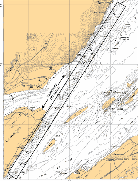
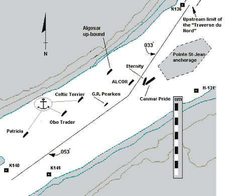
C 1.2.1 Vessels at Anchor
No vessel was allowed to pass the Alcor while she was in the Traverse du Nord. Several downbound ships were held above buoy K-136, the upstream limit of the Traverse du Nord. Five vessels were at anchor in a 3.5 nm stretch of the river between Pointe Saint-Jean and Rivière Maheu. The Canmar Pride was anchored closest to the Traverse du Nord, at the anchorage area known as "Pointe Saint-Jean". This anchorage, although not formally indicated on marine charts, is locally accepted as an area south of Pointe Saint-Jean on Île d'Orléans, far enough from traffic lanes so as not to impede or pose a risk to transiting vessels. When the Canmar Pride came to anchor, only the name of the anchorage area was given, and VTS did not request a more accurate position. Information at hand shows that the Canmar Pride had anchored on the extended line with the leading lights of 053° T, and at a distance of three cables from the intersection of the recommended routes 053°/033°. At anchor, the tanker Eternity was the vessel farthest from the Traverse du Nord, having anchored approximately 3.5 nm southwest of the Canmar Pride.
C 1.2.2 Other Vessels
The CCG vessel George R. Pearkes had been tasked to escort the Alcor to Québec; no other specific duties had been assigned this vessel. The upbound Algosar was permitted to follow the Alcor through the Traverse du Nord, without passing.
C 1.3 Personnel History
The pilots on board both vessels were Class A pilots for District 2; on the Eternity, the pilot had 21 years' experience as a pilot in this district; on the Canmar Pride, the pilot had 34 years' experience in this same district.
C 1.4 Weather, Current and Tide
At 2300 on 05 December 1999, the time of the near collision, visibility was reported as good, with winds out of the west at 10 knots. The tidal current was on the ebb, setting approximately 060° T at between two and three knots.
C 1.5 Occurrence Reporting Requirements
The Transportation Safety Board Regulations, made pursuant to the Canadian Transportation Accident Investigation and Safety Board Act, the Shipping Casualties Reporting Regulations, made pursuant to the Canada Shipping Act (CSA), and the Laurentian Pilotage Regulations, made pursuant to the Pilotage Act, all require a near-collision to be reported immediately by the fastest means available, one of the methods being a report to the nearest shore station. This is to be followed by a written report to appropriate authorities.
After the incident, the pilots and masters on both the Canmar Pride and the Eternity all concurred that there had been a risk of collision, but neither vessel reported this incident to VTS by radio. There are indications, however, that officers within LPA were summarily apprised of the incident through unofficial channels. After some preliminary inquiries, the decision was taken within LPA to not investigate further. TSB was informed of the near collision on 21 December 1999.
C 1.6 VTS in Canadian Waters
VTS operates under the auspices of the Vessel Traffic Services Zones Regulations, pursuant to the CSA, and administered by the Marine Programs Directorate of CCG, Department of Fisheries and Oceans. The service is carried out by the Marine Communications and Traffic Services (MCTS) program of CCG.
The objective of VTS is to protect the marine environment and improve the safety and efficiency of traffic movement, by providing the following services:Footnote 48
- a VHF traffic information and advisory service;
- a traffic clearance and screening service;
- a radar navigational assistance service; and
- a space management service, organizing ship movements in order to facilitate efficient traffic flow.
Under the regulatory regime, no ship shall enter, leave, or proceed within a VTS zone without having previously obtained a traffic clearanceFootnote 49 and a report shall be made to a marine traffic regulator immediately before beginning and after completing a departure manoeuvre in a VTS zone.Footnote 50
C 2.0 Analysis
C 2.1 Limitations Imposed by Navigational Practices
No prior arrangement was made among pilots of various vessels at anchor as to their order of departure, nor did VTS establish the order for vessel departure. Instead, each vessel made a decision in isolation and commenced weighing anchor; the Eternity first, followed by the Canmar Pride. As the Eternity was underway, she was required to keep clear of vessels at anchor. Although the pilot of the Eternity, the farthest vessel at anchor, was aware that he would have to pass other vessels at anchor, he did not closely monitor these vessels nor did he communicate with them to arrange safe transit. The pilot of the Eternity was aware that the Canmar Pride had begun weighing anchor. In fact, it was the pilot on board the Canmar Pride who twice raised concern about the developing situation. The pilot of the Eternity did not establish the precise position of the Canmar Pride, and close monitoring of the situation would have better enabled him to recognize, in sufficient time, that the Canmar Pride was anchored close to the channel.
A review of the chart indicates that the channel in the vicinity of Canmar Pride anchorage is some 0.9 mile wide. Hence, as the Eternity approached the Canmar Pride, the pilot on the former had a number of options available to him: to reduce the vessel's speed, or to pass either ahead or astern of the Canmar Pride. The Eternity's pilot opted to stay on the recommended track (marked on the chart), maintain her speed of 12 knots and pass ahead of the vessel. Once committed to the port alteration, and with the wind and current on the vessel's port quarter, the Eternity pilot was left with little alternative but to take last-minute emergency action; sufficient allowance had not been made for the vessel's set given the position of the Canmar Pride. This action, in conjunction with the emergency action initiated by the Canmar Pride pilot (going astern on the engine), barely extricated the vessels from a collision; passing clearance was some 30 m.
C 2.1.1 Issues Affecting Quality of VTS
Because there is no radar coverage of this area, VTS had to rely on information provided from vessels (by either the pilots or shipboard personnel) to generate a traffic image. To achieve this, VTS procedures call for communicating positions of vessels at anchor. In this instance, the anchored position of the Canmar Pride was reported as being at Pointe Saint-Jean anchorage. No range and bearing were given, nor was it requested by VTS. As the vessel was anchored close to the recommended track, she posed a potential threat to transiting traffic, given the circumstances which existed at the time of this occurrence. At no time did the Canmar Pride broadcast a SECURITÉ message to advise other vessels of this position. The absence of this information precluded VTS and vessels in the area from having a comprehensive overview of the traffic in the area and traffic-influencing factors - criteria essential for the safety of vessels operating within the VTS area. Further, the quality of VTS accident prevention measures depends on the system's capability of detecting a developing dangerous situation and giving timely warning of such dangers.Footnote 51 Precise information on anchorage positions enables the VTS officer to better understand the traffic situation and to more fully inform other vessels navigating in the area. Furthermore, precise VTS information allows vessels to better appreciate the risks associated with traffic in the area, thereby enhancing the safe conduct of vessels.
C 2.2 Closing and Re-opening of Channel
C 2.2.1 VTS Control and Direction
C 2.2.1.1 Normal Operating Conditions
The CSA requires that a vessel "obtain a traffic clearance" before departure. There is no intention on the part of CCG to attempt to navigate or manoeuvre ships from a shore station. Information provided to a vessel is intended to assist in the safe conduct of that vessel. Consequently, pilots make navigational arrangements between themselves and keep VTS apprised, so that pertinent information can be disseminated to other vessels. Under normal operating conditions, the system works well and the safety of vessels navigating in the VTS area is not compromised. Direct arrangements between pilots, therefore, have become an accepted group norm.
C 2.2.1.2 VTS Procedures for Closing and Re-opening of Channels
Closure of the navigational channel to river traffic is infrequent, but not unusual. During winter, VTS, in close coordination with the Québec Ice Office, can and does close the channel to traffic when circumstances warrant. The channel is only reopened upon advice and direction from Ice Office authorities, and vessels are dispatched in a controlled manner. This is consistent with the "space management services".htmlect of the VTS mandate.
A channel closure could result in placing a number of vessels at anchor or berthed, awaiting transit. Unlike normal operations, direction from the VTS (a central coordinating body) becomes essential for an orderly flow of traffic. This occurrence shows what can happen when this system becomes inoperative; the safety of vessels operating in the area is compromised and the risk to the environment is increased.
C 2.2.2 Involvement of Participants
VTS operations were influenced by the salvage operations; closing and re-opening the Traverse du Nord was one action under consideration. In this instance, the salvage plan was incomplete, in that it did not involve VTS, LPA or the Pilot Corporation at its inception. VTS was not apprised during the planning, development and execution of the refloating manoeuvre, and no specific directive was issued to VTS that would have helped an orderly flow of traffic.
C 2.2.3 Notice to Shipping (NOTSHIP)
The NOTSHIP (closure of channel) lacked specifics, in that it did not indicate that the channel was closed to other traffic "until further notice." Consequently, once the Alcor was refloated, each pilot unilaterally initiated action to transit the channel.
C 2.2.4 Coordination between TC and Pilots
Although TC officials had officially closed the channel to all traffic, the pilot(s) aboard the Alcor, with the tacit acquiescence of TC officials, made arrangements (with pilots of other vessels) to permit other vessels to transit the area (at 1740). This could have been interpreted by other vessels to mean that the channel was reopened. This underscores the need for centralized control and direction over channel status.
C 2.2.5 VTS Control and Authority Gradient
VTS did not exercise authority to direct traffic, but instead acquiesced to the pilots' actions. A pilot has many years' seagoing experience and interacts with a VTS officer who may have little or no sea experience. The resulting authority gradient generates a barrier that makes the VTS officer less prone to exercise authority, even in extenuating circumstances, effectively undermining VTS procedures.
The exercising of authority by VTS at this stage would have helped establish an orderly flow of traffic. On the other hand, lack of clear directives to VTS from either the pilots or TC authorities on the Alcor meant that MCTS officials were operating in a void, with no clear direction.
Given the complexity of navigational considerations, the coordination required, and the impact of the authority gradient, the participation of personnel well versed in the area of operation and the application of VTS operating procedures could help prevent the development of an authority gradient.
C 2.3 Effectiveness and Impact of Communication
Ship-to-ship, and ship-to-shore communication were imprecise and incomplete, in that:
- information provided by VTS to the vessels was limited to the opposing traffic;
- communication between vessels was rudimentary and did not reflect the added safeguards required in extenuating circumstances;
- no SECURITÉ message was broadcast by vessels departing anchorage; and
- the anchorage position of the Canmar Pride was close to traffic lanes and potentially an impediment for the transiting vessels. This was not reported to VTS or broadcast by the Canmar Pride.
A number of TSB investigations have highlighted the fact that accidents are often the product of ineffective, incomplete, untimely, or misunderstood communications.Footnote 52 A 1995 TSB study found that lack, or misunderstanding, of communication were significant factors identified in some 18% of the marine occurrences involving human factors.Footnote 53 The Board was concerned that unclear communications and delays in expressing concerns continued to compromise the safety of lives, vessels, and the environment.Footnote 54 This occurrence again highlights the importance of clear, complete and well-understood communications, be they among bridge team members, or between vessels, or between vessels and VTS. Further, it also highlights the need for effective control and coordination within the VTS operating area. Without it, vessels will operate in a void and navigation personnel will continue to make assumptions to the detriment of transportation safety.
Many accidents in the past, in particular, collisions, have been attributed to decisions based on assumptions that ultimately proved to be erroneous.Footnote 55 Risks associated with incomplete information have been highlighted in Rule 7, Risk Of Collision of the Collision Regulations, which reads, in part: "assumptions shall not be made on the basis of scanty information" The Chief Inspector of Marine Accidents (Great Britain) recently wrote, "in many instances a contributory factor to whatever the eventual incident was, involved someone assuming something was going to happen, or had been done."Footnote 56
In this occurrence, the following assumptions were made:
- The pilot on the Eternity did not verify that the channel was unimpeded. Information provided by VTS did not contradict this.
- The pilot on the Canmar Pride assumed he was to be the first to proceed downriver once the channel was re-opened. Consequently, he saw nothing inopportune with his anchorage position. Conditions that led to this belief included the perception that his vessel was the closest to the entrance of the Traverse du Nord, and that his vessel was the fastest of the group waiting to proceed downriver.
- VTS assumed that the Canmar Pride was anchored in the manner commonly employed for the Pointe Saint-Jean anchorage.
While it is recognized that erroneous assumptions can contribute to an occurrence, the availability and precision of information shapes the nature and the number of assumptions being made. The impact of incomplete or ambiguous information can be minimized through timely sharing of precise and complete information.
Safety is dependant upon, among other things, the level of shared situational awareness amongst the individuals piloting vessels in the channel. Situational awareness can be thought of as the mental model that an individual has of a given situation and time. Mental models develop from information related to the immediate situation and environment (such as location, speed, and presence of hazards) and information gained from education, training, and experience. In the absence of a complete set of cues for a given situation, fragmentary information may be combined with mental expectations and integrated (in the form of assumptions) into the mental model. In such situations, it is possible for different individuals to develop divergent models of their surroundings, even though they had the same information as a starting point.
Precise and complete communications are essential to generate a comprehensive overview of traffic and the factors influencing it. The resulting shared situational awareness increases the probability that a developing dangerous situation is recognized in a timely manner.
C 2.4 Marine Occurrence Reporting
Timely collection of occurrence information is an essential component of any safety system. Such timely reporting ensures that the relevant authorities are quickly apprised, so that search and rescue, pollution prevention, inspection agencies, and other organizations can be dispatched to mitigate risk to personnel, property, and the environment. Furthermore, it permits quality accident investigation action and provides a knowledge base through which trends can be analysed, deficiencies identified, and recommendations for change brought forth.
At a regional level, pilotage authority reporting requirements mandate that pilots submit incident reports so that the local authority can, where necessary, undertake an investigation with respect to policy, procedures, and practices. Reporting also provides the authority with a risk assessment tool to identify latent safety deficiencies before they lead to a major occurrence. Neither pilot properly advised VTS or any other agency, including the LPA, of the near collision. When the LPA became aware of the near collision, after some preliminary inquiries it decided not to investigate further. "Human nature being what it is, a near miss quickly gets downgraded into 'part of the job' and is forgotten".Footnote 57 This decision had the effect of obscuring (to the Authority) the safety sensitive information of vessels operating in pilotage waters.
In Canada, the TSB maintains a national occurrence database and information is available to the public both nationally and internationally.
The prime purpose of a pilotage service is safety. Compulsory pilotage areas are established for the benefit of the community to protect the environment, the waterway, and the port infrastructure from marine accidents. There is an expectation that all incidents will be properly reported and investigated. This will allow for the identification of safety deficiencies and commensurate safety action, thereby advancing transportation safety.
C 3.0 Findings
C 3.1 Findings as to Causes and Contributing Factors
- The navigation team aboard the Eternity did not appreciate, in a timely fashion, that a risk of collision with the Canmar Pride was developing, and they did not initiate communication with the former to arrange a safe passage.
- The lack of coordination between VTS, the pilots, and TC officials, combined with incomplete and imprecise communication, led to divergent interpretations of unfolding events, both ashore and afloat, resulting in confusion and the uncoordinated reopening of the channel.
- The anchorage position of the Canmar Pride, close to traffic lanes and potentially an impediment to transiting vessels, was not communicated to VTS or to other vessels by way of direct, two-way communications or by a SECURITÉ message, thus depriving other vessels of a vital navigation cue.
- A lack of procedural integrity by VTS operators, and the impact of an authority gradient between the pilots and the VTS operators, resulted in a loss of direction and control with respect to the orderly flow of traffic.
C 3.2 Findings as to Risk
- LPA did not fully investigate the events surrounding the near collision and were unable to avail themselves of safety-sensitive information.
C 3.3 Other Findings
- The near collision was not reported in a timely manner by either the Eternity or the Canmar Pride. The quality of information and timely identification of safety deficiencies are compromised when transportation occurrences are reported late, or not at all.
Part D Vessel Survey
D 1.0 Factual Information
D 1.1 Vessel Survey Requirements
International Maritime Organization Resolution A.744(18), Guidelines on the Enhanced Programme of Inspections During Surveys of Bulk Carriers and Oil Tankers, adopted on 04 November 1993 and subsequently incorporated as Chapter XI in the International Convention for the Safety of Life at Sea, formally came into force 01 January 1996.
Under the Enhanced Survey Program (ESP), "special" surveys are conducted at five-year intervals by the vessel's classification society. In the case of bulk carriers, surveys become more rigorous as a vessel ages. Additionally, "annual" surveys are required, the second or third of which must be a more detailed "intermediate" survey. These survey reports may also incorporate memoranda that address and monitor specific ongoing items of concern arising from any preceding survey.
For operational convenience, the scheduling of surveys is subject to some flexibility, (such that the intervals between routine annual and intermediate surveys may vary by plus or minus three months) while ensuring that actual elapsed time between special surveys is maintained substantially at five years.
D 1.2 Hull Survey and Inspection History - Alcor
D 1.2.1 Special Hull Survey
In accordance with ESP requirements, and while named Mekhanik Dren, the (then) 20-year-old vessel was the subject of a special survey in 1997, while at Shanghai, in the People's Republic of China.
Principal structural areas subjected to close-up visual inspection included:
- all cargo holds, side framing, inner bottom and transverse watertight bulkheads;
- internal structure of all upper wing ballast tanks;
- internal structure of all double bottom water ballast tanks; and
- main deck, side and bottom shell plating.
Ultrasonic thickness gauging of the principal hull girder structural members was carried out in accordance with class requirements and recommended International Association of Classification Societies procedures.
The inspections and thickness gauging resulted in extensive structural repairs and replacements, totalling 260 tonnes of steel, mainly while the vessel was afloat. Principal structural repairs were in way of upper wing water ballast tanks 1, 2, 3 and 4, port and starboard. Repairs in these tanks included renewal of several sections of main deck longitudinals, and repair or partial replacement of transverse webs, end bulkheads, main deck and wing tank sloping bottom plating.
Internal inspections showed that cathodic protection systems were not fitted in any of the vessel's water ballast tanks. Double bottom water ballast tanks (1, 2 and 3, port and starboard) were fitted with a protective coating, which was recorded as being in "fair condition". All upper wing water ballast tanks were recorded as being uncoated.
Concluding remarks of the hull survey report included a notation: "due to no protection or coating in topside water ballast tanks, it will be necessary to carry out common survey for it during next Annual Surveys."
Hull, machinery, and electrical enhanced surveys, together with related repairs were completed to the satisfaction of the attending class surveyors, and ESP was added to the vessel's Russian Maritime Register of Shipping (RS) class notation symbol. The special hull survey was completed and approval assigned in accordance with RS class requirements on 20 June 1997.
D 1.2.2 Routine Annual Hull Survey (1998)
The first routine annual hull survey was carried out in 1998, while the Alcor was afloat in the Port of London, United Kingdom. The survey included general examination of the hull, forepeak and afterpeak tanks and cargo holds, as well as close-up inspection of two forward holds and attention to any newly incurred structural damage or ongoing, structure-related notations of previous surveys.
No newly-incurred structural damage or substantially corroded areas were noted at this time. The absence of cathodic protection systems in any of the vessel's ballast tanks was again recorded, and the condition of the internal coatings in double bottom water ballast tanks was reported to be "fair". The routine annual hull survey was completed to the satisfaction of RS class surveyors, and approval assigned on 19 March 1998.
D 1.2.3 Port State Control Survey
In accordance with the Canadian Bulk Carrier Inspection Regime and Port State Control (PSC) requirements, the Alcor, as a dry bulk carrier more than 15 years old, was inspected while at Vancouver, British Columbia, on 25 September 1998.
The inspection showed that an oily water separator bypass was installed in the vessel, which contravened regulatory requirements of the International Convention for the Prevention of Pollution from Ships. The master was informed and RS was advised of this contravention. The report called for the earliest implementation of remedial action to ensure both regulatory compliance and RS approval. No internal or close-up structural inspections were carried out at this time, and the vessel was not detained.
The Alcor was scheduled to undergo a PSC inspection upon arrival at Trois-Rivières, Quebec, with the inspection to include visits to the forepeak, afterpeak, upper wing tanks and cargo holds.
D 1.2.4 Routine Annual Hull Survey (1999)
A second routine annual hull survey was carried out while the vessel was afloat in the port of Bombay, India, in 1999. This survey included general examination of the hull, hatch covers, coamings and fittings, cargo holds, and forepeak and afterpeak water ballast tanks.
The lower 25% of the side framing and adjacent shell plating in the cargo holds, and all of the internal structure of each of the upper wing water ballast tanks were subjected to a close-up survey.
On general examination, the hull, hatch covers, coamings and fittings, all cargo holds, forepeak and afterpeak water ballast tanks were found to be satisfactory. A close-up survey showed the lower side framing in all cargo holds and the internal structure of all upper wing water ballast tanks to be in satisfactory condition. It was also recorded that "there was not found substantially corroded areas."
The protective coating in the forward and afterpeak water ballast tanks was reported to be in "poor" condition, while that in all the cargo holds was reported as "good". The absence of cathodic protection systems or protective coatings in any of the upper wing water ballast tanks was also recorded.
Concluding remarks of the report included the notation:
Due to no protection/coating in topside ballast tanks Nos 1, 2, 3 & 4, (P & S) it will be necessary to carry out measurements of thickness of sloping plating and bulkheads in tanks, as well as close-up survey of framing in topside tanks, fore peak and after peak for it during Intermediate Survey, but not later than 15-04-2000.
The second routine annual survey was completed to the satisfaction of RS class surveyors and approval assigned on 19 January 1999.
D 1.2.5 Occasional Hull Survey
At the request of the owners, an additional hull survey was carried out by RS surveyors at St. Petersburg, Russia, in August 1999. This survey (designated "occasional" by RS) was to ascertain the vessel's compliance with requirements of the International Maritime Dangerous Goods Code and the Code of Safe Practice for Solid Bulk Cargoes with respect to the possible future carriage of various types of ammonium nitrate fertilizers.
At this time, the external survey found no newly incurred structural damage to the hull. The cargo holds and hatch covers were inspected and found in order. It was also confirmed that the vessel carried an updated Stability and Strength Booklet (operating manual) approved by RS on 20 January 1999.
Approval for the carriage of ammonium nitrate fertilizers in cargo holds 1 and 4 was assigned by RS surveyors on 09 August 1999.
D 1.3 Hull Construction
The hull was generally constructed with shipbuilding quality Grade A mild steel, while the main deck port and starboard side stringer plates and side shell sheer strakes were made of more notch (fracture) resistant Grade D steel. The layout of the principal longitudinal structural members in way of the cargo hatches, holds, upper wing ballast tanks, and double bottom tanks is shown in Figure 11.
TYPICAL CROSS SECTION
PRINCIPAL CONSTRUCTION DETAILS
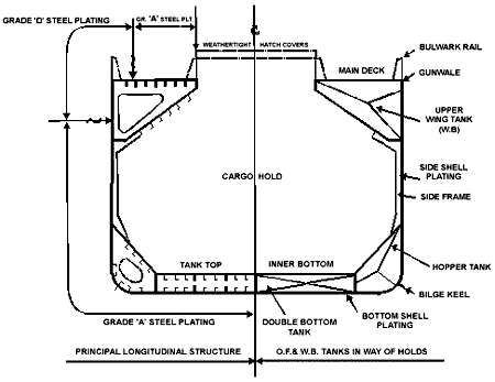
D 1.4 Post-Occurrence Hull Survey
A close-up visual inspection of the damaged main deck and the internal structure of four of the upper wing water ballast tanks was carried out while the vessel was aground. Inspections of the side shell, side framing, inner bottom and transverse bulkheads in way of all of the cargo holds were carried out when the vessel was refloated and unloaded.
The internal structure of the cargo holds, including the inner bottom tank top and hopper tank sides, was found to be generally free of any significant localized damage or distortion that might have been incurred prior to this occurrence. Side framing and top and bottom bracket connections throughout the cargo holds were free of any localized impact damage or significant wastage, and the welded connections to the side shell and hopper side plating were in good order.
Localized minor corrosion pitting was found in the external painted surfaces of the port and starboard sides of the main deck plating throughout the mid-length of the vessel. Exposed deck plating inside the line of hatches was extensively corroded due to breakdown of the original paint protection.
The internal structure of port and starboard upper wing water ballast tanks 2 and 3 showed extensive and active corrosion, particularly in way of the sloping tank bottom plating and transverse web frames. Large areas of these structural members were affected by and covered with hard and loose scale, large quantities of which had fallen loose and accumulated at the bottom of the tank. Many of the most recently renewed main deck longitudinals were comprised of relatively short lengths of steel flat bar, and the original members were extensively corroded.
The ends of the longitudinals, exposed in way of the principal main deck failures, showed fillet-welded connections to the main deck plating with irregular throat sizes and leg lengths, grooving and undercutting of the deck plating, and a lack of penetration. In addition to those in way of the principal main deck failures, a further 19 fractures were found in the main deck longitudinals. Some of these fractures were in way of butt joints, where the welding had incurred preferential corrosion; others were in way of heavily-corroded and locally-thinned metal of the original longitudinals.
Ultrasonic thickness gauging measurements were made of the main deck, upper wing water ballast tank internal structures and the side shell plating, both forward, aft, and immediately adjacent to the principal transverse hull fractures. Average thickness of the main deck plating was found to be generally 8% to 10% less than when the vessel was originally built, while that immediately in way of the principal failures was, on average, some 15% to 18% less, with some localized heavier pitting. Average thickness of the most recently renewed deck longitudinals was 94% of their original size, while the most inboard and original members were generally reduced to 75%, with localized reductions of as much as 50%.
The average thickness of the sheer strakes and side shell plating were generally 95% of the originally fitted structure, while that of the side shell immediately in way of the principal failures was some 76%. Localized thickness of the side shell plating near the bottom of the upper wing ballast tanks and adjacent to the principal hull failure was 65% of that originally fitted. The upper strakes of the sloped bottom plating of the upper wing water ballast tanks were generally 75% to 90% of the original thicknesses; however, the lower strakes and the webs of the transverse framing were reduced to 55% to 60%. The lower strakes of the sloping plating immediately adjacent to the principal transverse failures in upper wing water ballast tanks 2 (S) and 3 (P) were locally reduced to some 35% of their original thickness.
A transverse brittle fracture, some two metres in length, was found in the main deck plating in way of port side upper wing water ballast tank 3, immediately aft and parallel to the bulkhead at frame 108. The fore and aft location of this fracture is coincident with the principal failure on the starboard side of the main deck. However, the propagation of the port side fracture was arrested where it reached the circular welded connection of a sounding pipe deck penetration fitting.
Several small transverse fractures, which occurred in the port and starboard sides of the main deck plating prior to the principal hull failure, were located at that time; their progress was halted by drilling crack-arresting holes at their ends. Subsequent internal inspections showed that these fractures were generally in way of deck longitudinals and coincided with sudden discontinuities in their weld connections or thickness, and also in way of fractured or corroded butt welds.
Close-up examination of the exposed ends of the principal fractures across the port and starboard sides of the main deck plating and in the side shell plating showed chevron-shaped markings indicative of rapid brittle fracture failure. The pattern of the markings indicated that the principal structural failures were initiated in the main deck plating in way of uneven, undercut or deteriorated fillet-welded connections of deck longitudinals and adjacent, localized corrosion pitting. The failure pattern also indicated that the fractures propagated from the deck plating into the deck longitudinals and down the side shell plating. The brittle fractures continued until the tensile loading induced by the hogging bending moment which acted on the hull, passed below the neutral axis of the midship section structural modulus and became compressive in nature.
D 1.5 Sister Ships
Subsequent to the Alcor occurrence, the three sister ships (the Cheetah, the Lynx, and the Aghios Nicolaos) were identified as ships of particular interest (SPI) by Transport Canada Marine Safety (TCMS). This in effect "red flagged" these vessels and targeted them for more detailed scrutiny if and when they entered Canadian waters.
As an SPI, the Cheetah underwent a PSC inspection in the Port of Sept-Îles, Quebec, on 07 April 2000. PSC officers found fractured deck longitudinals in various locations in way of top side water ballast tanks 2 and 3. As well, numerous cracks on deck appeared to be emanating from the same fractured deck longitudinals beneath. Certain sections of the longitudinals had been recently renewed and fillet welds, joining the old with the new, were the origin of the initial cracks. Finally, six web frames in way of the top side tanks were found corroded and in need of insert plates.
The Lynx was in Canadian waters within two weeks of the Alcor grounding and TSB investigators had an opportunity to board this vessel. The steering station was in all respects similar to that found on the Alcor, and the condition of the No 2 top side water ballast tanks was markedly better. Tank coatings here were relatively intact and cathodic protection was in use. (The crew was in the process of changing the zinc anodes during the TSB visit.)
The Aghios Nicolaos has not been reported within Canadian waters since the Alcor grounding.
D 2.0 Analysis
D 2.1 Bulk Carrier Inspection and Enhanced Surveys
D 2.1.1 Hull Failure Sequence
The grounded after end of the Alcor was supported while buoyant support of the forward end fluctuated throughout the diurnal tidal ranges. Consequently, the vessel was repeatedly subjected to very high bending moments. Because two of the forward double bottom tanks were breached during the initial grounding, the forward end was only partially buoyant and the resulting downward deflections of the bow at each low tide caused the hull to take up a hogged attitude. While in the hogged condition, the upper member (main deck and its longitudinals) of the hull girder was in tension and the lower member (bottom shell and inner bottom) was in compression (see Figure 8).
For vessel construction, the midship section modulus, configuration, and grade(s) selection of steel are designed to ensure that the as-built intact structure will, with safety margins, withstand loads likely to be imposed on a vessel in the prescribed cargo and ballast loading conditions encountered when afloat in normal service. However, in the event of grounding, when total buoyant support is reduced and longitudinal distribution is much less uniform than when free-floating, bending stresses imposed on a hull can exceed the safety margin ensured by the approved maximum design figure.
Ultrasonic inspection showed that the average reductions in thickness of the main deck plating, the most recently renewed longitudinals, and the sheer strake and upper side shell were within regulatory limits before replacement was required. However, some of the average or localized wastage and corrosion pitting in many of the original deck longitudinals, together with web frames and lower sloping bottom plating in the upper wing water ballast tanks, exceeded the maximum 25% and 30% allowable reduction margins before replacement was necessary.
The grounded hull was subjected to bending stresses beyond normal design criteria. The ability of the vessel to resist longitudinal bending and wracking stresses, however, was reduced due to corrosion wastage, localized pitting and damage to parts of the upper hull structure. Because of the river bottom profile at this location and the position and loaded condition of the Alcor, it is highly likely that hull failure would have eventually occurred, regardless of hull condition. Nonetheless, deterioration of the upper hull structure contributed, in part, to the rapidity of the hull failure.
D 2.1.2 Quality of Repairs
Extensive repairs carried out at Shanghai, People's Republic of China, in 1997 were concentrated on the upper wing water ballast tanks. Several sections of main deck longitudinals were renewed, as were the repair or partial replacement of transverse webs, end bulkheads, and main deck and wing tank sloping bottom plating. After the Alcor was damaged, an opportunity to conduct an unscheduled (and independent) inspection was possible. The ends of the exposed longitudinals in way of the main deck fractures showed fillet-welded connections to the main deck plating with irregular throat sizes and leg lengths. There was also grooving and undercutting of the deck plating and a lack of penetration of some of these welds. A further 19 fractures were found in the main deck longitudinals at other locations. Several of these fractures were in way of butt joints, where the weld had incurred preferential corrosion; others were in way of heavily-corroded and locally-thinned metal of original longitudinals.
The varying quality of repairs has been previously underscored.Footnote 58 Coincidentally, the sister ship Cheetah also had certain sections of the deck longitudinals recently renewed. The PSC inspection conducted on 07 April 2000 revealed that fillet welds, joining the old with the new, were the origin of cracks found on deck.
Quality control during vessel construction is an essential part of ensuring a safe vessel. The same rigorous standards for quality control used during construction should also be applied to repairs, especially major repairs to a vessel's principal structural elements.
D 2.1.3 Quality of Inspections
The internal structure of port and starboard upper wing water ballast tanks 2 and 3 showed extensive and active corrosion when inspected by TSB investigators in November 1999. Routine annual class surveys in 1998 and 1999 both acknowledged the absence of cathodic protection systems or protective coatings for these areas. The 1999 survey noted that the internal structure of all upper wing water ballast tanks was in satisfactory condition. It was also recorded that "there was not found substantially corroded areas."
Although it is inherently difficult to measure the success of the ESP, some improvement in safety has resulted. However, unsatisfactory conditions remain. In at least four highly publicized accidents since December 1999, hull failure due to structural inadequacies was suspected. Each vessel was subject to the ESP, and was duly certified and classed:
- Erika, broke and sank off France in December 1999.
- Leader L, broke and sank in the Atlantic Ocean in March 2000.
- Treasure, broke and sank off South Africa in June 2000. and
- Levoli Sun, broke and sank off France in October 2000.
With the Alcor, there was a significant difference between the observed condition of the upper wing ballast tanks in November 1999 (after the grounding), and the condition reported in the January 1999 routine annual survey. It would appear unlikely that such a marked deterioration could occur during the 11-month period between the two surveys, since these tanks routinely were kept dry, and hold 3 was used as the principal means of ballasting the vessel.
This occurrence, and the four mentioned above, reveal concerns with the quality control of inspections conducted under existing ESP procedures.
As a foreign bulk carrier entering a Canadian port, the 23-year-old Alcor was subject to inspection by TCMS in accordance with PSC and the Bulk Carrier Inspection Programme requirements. Such an inspection was scheduled for 10 November 1999, at Trois-Rivières, Quebec.
D 3.0 Findings
D 3.1 Findings as to Causes and Contributing Factors
- The grounded vessel was subjected to bending and racking stresses that exceeded normal operational design criteria. However, the deteriorated condition of parts of the Alcor upper hull structure contributed to the rapidity of hull failure.
D 3.2 Findings as to Risk
- The quality of inspections conducted under the existing ESP is not consistently held to the standard required by the program. Consequently, vessels which may be unseaworthy continue operating, thus compromising the safety of these vessels and subjecting personnel, property, and the environment to unacceptable risk.
- The quality of welding repairs in way of the renewed main deck longitudinals was less than satisfactory.
E - 4.0 Safety Action
E 4.1 Action Taken
E 4.1.1 Marine Communication and Traffic Services
Subsequent to the near collision of 05 December 1999 between the vessels Canmar Pride and Eternity, Marine Communications and Traffic Services (MCTS) Québec undertook an internal review. The results of this review included the following findings:
- Information transmitted to and from VTS was, at times, unclear and did not conform to the accepted normalized lexicon.
- Several internal procedures were not followed, in particular noting a vessel's exact anchorage position (Canmar Pride).
- Clear and unequivocal authorization to depart anchorage was never given by VTS. Authorizations were tacit and in response to declarations made by the respective pilots as they were departing - a subtle but fundamental difference that contradicts VTS standing procedures and the CSA.
- Downbound traffic was not managed once the Alcor left the Traverse du Nord, in particular the staging of departures to ensure safe and efficient navigation within the channel.
Additionally, the internal MCTS review identified the use of unmonitored VHF channels by pilots to exchange information that should normally be communicated on monitored channels. The workload of the VTS officer was unduly increased due to their "unofficial" monitoring of these communications and then having to ask the pilots to confirm, on monitored channels, actions which were now known to VTS but not known to other river traffic. The lack of recordings for these unmonitored channels renders post-incident analysis difficult, if not impossible, and precludes confirmation of this practice.
Actions taken by MCTS after the groundings and the near-collision include:
- documenting all information and parameters of the events relevant to these incidents, with a view to developing a simulation scenario for training purposes;
- increasing internal quality control measures with respect to procedural integrity and quality of decision making by VTS officers and team leaders;
- reviewing operating procedures within the VTS station with a view to increasing the active participation of VTS officers and improving traffic management; and
- meeting with all VTS team leaders to instill the importance of quality decision making in all.htmlects of their service.
E 4.1.2 Transport Canada and Fisheries and Oceans Canada
Subsequent to the Alcor groundings and refloating, regional representatives of Transport Canada and Fisheries and Oceans Canada held a combined review and agreed upon common action:
- to identify a "go team" for initial response;
- to develop and ratify a memorandum of understanding (MOU) between the two ministries for environmental response;
- to ensure an annual review of the environmental response MOU; and
- to create a permanent inter-departmental working group.
Additionally, the review, which is still underway, will consider the need for TC to develop a risk evaluation methodology for marine incidents.
TC took the following action:
- An MOU was signed with Fisheries and Oceans Canada on 19 October 2000. The MOU defines the role responsibilities of the TC marine safety surveyor as a representative of CCG in the event of marine pollution from a vessel, specifically in circumstances where the surveyor boards the vessel before (and until) the CCG representative arrives on board.
The TSB issued Marine Safety Information Letter (MSI 04/01) to TC on 24 May 2001. This information letter points out the shortcomings of working in an ad hoc fashion and stresses the advantages of a risk management model for navigation-related emergencies, including groundings in high tidal amplitude waters.
Fisheries and Oceans Canada took the following action:
- An MOU was signed with TC on 19 October 2000 (same as above).
- Local area (grounding environs) sounding criteria have since been established as guidance for salvors. A list of potential local contractors that meet the criteria was also developed.
E 4.1.3 Transport Canada
The three sister ships of the Alcor, as well as all bulk carriers constructed at the same shipyard for the three-year period extending one year before and after the Alcor's construction, were identified as SPIs and communicated to signatories of the Paris and Tokyo PSC Protocols.
E 4.1.4 Pilot Corporation
E 4.1.4.1 Training
Since 2001, at the insistence of the Pilot Corporation, the ship-handling course has been made available to Class C pilots. As of August 2002, all Class C pilots have taken this course.
E 4.1.5 Laurentian Pilotage Authority
E 4.1.5.1 Pilot Relief
The TSB issued Marine Safety Information Letter MSI 05/01 to the Laurentian Pilotage Authority (LPA) on 18 May 2001. This information letter points out that, in the absence of clear criteria regarding relief of pilots subsequent to an emergency, an occurrence pilot is placed in a difficult position of making a decision. It goes on to emphasize that, under the given circumstances, a pilot may not be the best person suited to make the decision - a decision that may have a significant impact on the safe navigation of the vessel.
As yet, no formal program has been instituted by LPA to address relief of pilots subsequent to special circumstances such as a grounding or other emergency.
E 4.1.5.2 Pilot Training
The TSB issued a Marine Safety Information Letter (MSI 06/01) to the LPA on 24 May 2001. This information letter expressed concern that the current training and experience requirements for C-1 pilots, and the methodology used to evaluate them, are such that pilots may not be sufficiently prepared to pilot larger vessels. Further, it goes on to highlight that there is no effective competency-based training and evaluation program to help ensure that candidates possess the required abilities and attain a level of competency commensurate with the appropriate class and sub-class of licence.
Following recommendation 9 of the 1999 Canadian Transportation Agency's (CTA) Review of Pilotage Issues, Report to the Minister of Transport, the pilotage authorities have begun the process of developing a system for assessing pilots' competence and quality of service.
E 4.1.5.3 Risk Assessment
Following Recommendation 1 of the 1999 CTA pilotage review report, the LPA, in conjunction with the other pilotage authorities, has since developed a risk evaluation tool. For 2002, the objective was to use this new tool to evaluate three priority issues; 1- compulsory pilotage limits in so far as vessel size within the Laurentian region, 2-the use of docking pilots in District 2, and 3- double pilotage requirements in Districts 1 and 2. The work is ongoing.
E 4.1.5.4 Regulatory Change - Shipping Casualty Reporting
In June 2002, the Laurentian Pilotage Regulations were amended (SOR/2002-242). The meaning of the word "incident" was clarified and reinforced. Any holder of a pilotage licence or certificate who performs pilotage duties on a ship in a compulsory pilotage area must report immediately to LPA any incident or accident as defined by the Transportation Safety Board Regulations.
E 4.1.6 Sister Ship Operators
Subsequent to Marine Safety Information Letter (MSI 05/99), the manager of two sister ships, the Cheetah and the Lynx, required a protective latch to be installed on the steering mode selector (SMS) switch of the Hokushin helm units of both. The protective latch positively locks the switch in the HAND mode and must be lifted in order to turn the SMS switch to another position.
Subsequent to the numerous structural defects found during the PSC inspection of the Cheetah at Sept-Îles on 07 April 2000, the vessel was detained for repairs. Completion of repairs required 10 days.
E 4.1.7 Russian Maritime Registry of Shipping
Since the Alcor occurrence, the Russian Maritime Registry of Shipping has implemented guidelines for surveys of vessels more than 20 years old. Also, a working group, based out of St. Petersburg, Russia, has been established to serve a quality control function for surveys of bulk carriers and tankers under the ESP.
E 4.2 Action Required
E 4.2.1 Emergency Preparedness
When responding to accidents, such as groundings involving large vessels, the situation can be complex, involving several different requirements, agencies, and personnel. Time also plays a critical role in determining what corrective action can be taken. Decisions have to be taken quickly and, with a measure of uncertainty as logistics associated with the mobilizing of people and equipment to accident sites may require significant effort. Further, solutions to problems must be carefully considered by all parties as the actions taken to resolve the situation do, in themselves, present their own risks that have to be properly assessed and managed in a dynamic environment.
Instances are on record where incomplete/improper risk assessment of vessels involved in an accident has led to an escalation of the incident. Examples include, among others, the Torrey Canyon (1967), the Exxon Valdez (1989), the Amoco Cadiz (1978), the Sea Empress (1996). Similar safety deficiencies have been repeated in the accident involving Alcor and the subsequent events. The shortcomings identified in the Alcor occurrence were:
- inadequate response to the initial grounding contributing to the escalation of the incident;
- less-than-optimal use of tugs during salvage operations, culminating in the vessel running aground a second time and sustaining extensive damage;
- all of the key parties were not involved in the planning and development of the salvage plan, resulting in an uncoordinated approach to refloat the vessel and the near collision of the tanker Eternity and the container vessel Canmar Pride;
- the working relationship of the bridge team during salvage operations was fragmented and uncoordinated, with the vessel almost grounding for a third time;
- there was no contingency plan for navigation-related emergencies, leading to an uncoordinated approach to handing the emergency, and
- the lack of a contingency plan precluded objective assessment by government officials of the timeliness and appropriateness of the emergency response.
Following the grounding of a vessel, it is incumbent upon the owner to take timely and appropriate action to respond to the situation and initiate remedial action. Various governmental organizations are on scene, each with complementary and interlaced mandates. TC has the general superintendence of all matters relating to the safe operation of ships, salvage and, subject to the Canadian Transportation Accident Investigation and Safety Board Act, shipping casualties. Fisheries and Oceans Canada has the general superintendence of all matters relating to the navigation system, wrecks and receivers of wrecks, and for responding to discharges of pollutants from vessels. Pilotage Authorities are involved in that they provide assistance to the vessel's navigation team. In the aggregate, these government organizations have a responsibility and an accountability to ensure that actions by the owner are correct and address the risks. Therefore, it is essential that they be fully prepared.
In the marine environment, the Canadian Coast Guard (CCG) has contingency plans for responding to maritime search and rescue (SAR) and discharge of pollutants by vessels. However, no formal structured management system, together with an overarching contingency planning, exists for other navigation-related emergencies in Canadian waters.
During emergencies, such as a grounding, various governmental representatives arrive on scene, principally TC and Fisheries and Oceans Canada, and they assume an observer/advisor status. However, as an emergency escalates many agencies/ departments at all levels of government (federal, provincial, local) as well as commercial interests could be involved. The role of an observer/advisor is to assess timeliness and appropriateness of the emergency response and, where deemed appropriate, give directions in relation to the emergency responseFootnote 59 However, there is no performance criterion against which the emergency response can be measured. Instead, there is heavy reliance placed on personnel expertise and experiences. Appropriate tools are not provided to facilitate the objective assessment against TC's or Fisheries and Oceans Canada's expectations of the timeliness and appropriateness of measures/actions taken by the owner's representatives and other entities. Without a formal structured management system, together with an overarching contingency planning for navigation-related emergencies, the observer/advisor's effectiveness is limited to the individual's initiative and that person's ability to fully g.html the complexities and to influence or, at some point, to direct or to stop the action to be taken because the desired outcomes cannot be reasonably achieved.
The owner's need to be prepared for an emergency and to take relevant action on board has been recognized in Article 8 of the International Safety Management Code (ISM Code). The Code requires companies to establish procedures/plans to identify and respond to, among others, navigation-related emergencies such as a grounding. In an emergency situation, there are several factors which are beyond the knowledge/expertise of the ship's master/owners; e.g., local conditions/environment, availability of resources, etc. There is, therefore, a need for the authorities to be prepared to assess the adequacy of responses to emergency situations and to take appropriate action to facilitate the implementation of the plan.
A salvage operation, by its very nature, is extremely complex and fluid; success depends upon the thoroughness of the plan and the effectiveness of its execution. The dynamic nature of salvage operations often requires ad hoc problem solving and decision making, a situation conducive to increased error. A structured approach, therefore, provides a framework around which informed decisions can be made. Such an emergency management approach by TC and CCG helps ensure that the vessel owners' response to deal with the emergency at various stages of its development is effective and appropriate under the circumstances. Further, it would ensure the owner's response plan identifies all risk and considers all risk mitigating options. Such an integrated approach would foster prudent and effective understanding, decision making and communication of the measures taken to resolve the emergency and permit continuous evaluation of its effectiveness.
The Board recognizes that emergency response management structures and risk-based decision-making models are used in response to specific marine emergency situations that do not include response to navigation-related emergencies. Further, noting the complementary mandates of TC and CCG to foster the safety of vessels and to protect the marine environment and, acknowledging the important role of pilotage authorities in providing valuable information on the operation of ships in pilotage waters, the Board believes that a planned and coordinated approach is necessary to deal with navigation-related emergencies in Canadian waters while supporting the vessel owners' efforts to deal with an occurrence. The Board, therefore, recommends that:
The Department of Transport, the Department of Fisheries and Oceans, and Canadian pilotage authorities, in consultation with marine interests, develop, implement and exercise contingency plans to ensure that risks associated with navigation-related emergencies are adequately addressed.
Transportation Safety Recommendation M03-03
E 4.3 Safety Concern
E 4.3.1 Pilot Performance
The critical role of pilots in ensuring the safe passage of vessels is well understood. Pilots work on a variety of ships with diverse handling characteristics and, at a critical phase of a ship's voyage, are introduced to bridge teams with a wide range of cultural and linguistic.htmlects. The challenge, therefore, in such a dynamic operating environment, is to ensure that pilots have the necessary competencies and support to be able to carry out their duties in the wide range of circumstances they encounter.
A number of TSB investigations involving vessels under the conduct of a pilot have revealed safety deficiencies for which recommendations were made.Footnote 60 The safety issues addressed factors that affect pilot performance. These included the following:
- pilot/master information exchange;
- pilot performance degradation due to fatigue;
- pilot skill upgrading, training and training validation;
- pilot bridge resource management training and practices; and
- pilot fitness for duty.
The investigations also revealed that a systematic approach to fatigue management and periodic audits to evaluate pilot proficiency and skills are usually absent from pilotage organization regimes. Thus, in 1999, following the investigation of the grounding of the bulk carrier Raven Arrow, the Board recommended that the pilotage authorities develop and implement a safety management quality assurance system.Footnote 61 This recommendation was issued on the heels of a similar recommendation issued by the CTA, which called for pilotage authorities to develop and implement a fair and reasonable system for assessing pilots' competence and quality of service.Footnote 62 In response to the two recommendations, the Minister of Transport tasked the pilotage authorities "to develop a quality assurance system in accordance with the needs and characteristics of their respective regions".Footnote 63 The pilotage authorities subsequently introduced a methodology for risk-based decision-making (pilotage risk management methodology) for use by pilotage authorities to ensure the efficiency, viability, and safety of the Canadian pilotage system and respond to the legitimate needs and expectations of all its users.
The Board commends the actions taken as a positive step toward furthering safety of vessels operating in the Canadian pilotage waters. However, the Board notes that the application of pilotage risk management methodology is limited to supporting decisions for designated compulsory pilotage areas, the size and type of vessels subject to compulsory pilotage, denying requests for waivers, and the requirement for double pilotage in designated pilotage areas. As a consequence, additional improvements to the safety of operation of a vessel in pilotage waters that may be associated with other pilotage conditions, practices, and procedures cannot flow naturally from a systemic analysis. The TSB is aware that among some of the pilotage authorities:
- the extent of training for preparing pilots for navigation-related emergencies and to respond to non-routine events is limited;
- attendance at certain pilotage training courses is dependent upon seniority;
- there is no requirement for competency audits of pilots after training;
- training validation is not carried out to ensure that the training given to pilots is effectively transferred from the classroom to the operational front;
- duty hours for pilots vary, as do the requirements for the need for a second pilot; and
- no formal guideline or procedure is in place concerning the relief of pilots involved in an occurrence.
Implementation of a risk-based methodology approach to address all pilotage issues, be they regulatory, contractual, or operational, would ensure that risk reduction is a prime consideration in the operational environment.
In 1998, a study entitled Modernization of the Pilotage Certification Process in the Laurentian Pilotage RegionFootnote 64 was undertaken to examine the modernization of the pilotage certification process for shipboard personnel (the study did not look at the pilot licensing process) and highlighted several pilot performance-related issues. These issues included a competency-based training and validation program, performance-based testing and an infrastructure necessary for program delivery.
The Board also notes that the pilot performance-related issues identified by this study could be applied equally well, but remain, for the most part, unaddressed within the pilot licensing process.
Effective safety management systems enable organizations to identify safety deficiencies and evaluate the associated risks so that corrective action can be taken or the risk minimized before accidents occur. Given that the current application of the pilotage authorities' risk management methodology is limited and that the pilot licensing process has yet to fully address key performance-related issues, the Board is concerned that residual risks continue to exist and may compromise overall safety of other pilotage operations and performance.
This report concludes the TSB's investigation into this occurrence. Consequently, the Board authorized the release of this report on .
Appendices
Appendix A— Helm Simulations
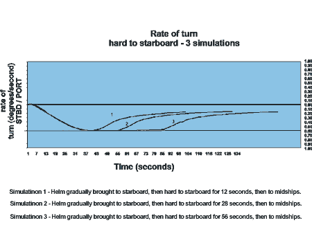
Appendix B— Canadian Transportation Agency Pilotage Review Report-1999
Section 157 of the Canada Marine Act, which came into force on 01 October 1998, contained a provision that amended the Pilotage Act by adding a requirement for the Minister to further review the pilotage system. The impetus for this review stemmed from the 1995 National Marine Policy, which recognized a need for further analysis of some of the more contentious issues within the current pilotage regime.
The objective of the review was to conduct a forward-looking examination of the marine pilotage system and to develop recommendations to ensure Canada has an efficient, viable, and safe pilotage system to meet the ongoing and long-term expectations and demands of all users.
The parameters set forth in the legislation were fairly precise as to what issues were to be reviewed. Specifically, five distinct subject areas were covered:
- pilot certification process for masters and officers;
- training and licensing requirements for pilots;
- compulsory pilotage area designations;
- dispute resolution mechanisms; and
- measures taken in respect of financial self-sufficiency and cost reduction.
On 11 August 1998, the Minister wrote to the Chair of the Canadian Transportation Agency (CTA), tasking the CTA with the conduct of the review.
The CTA received written submissions, convened two national meetings, and held regional consultations with interested parties. All facets of the marine industry were active participants at many of these sessions. The CTA provided its final report to the Minister on 31 August 1999.
The CTA review contains 21 recommendations, all with which Transport Canada concurs in principle. Certain recommendations cannot be implemented exactly as submitted, and some of the proposed regulatory changes will require further legal scrutiny before being adopted...
Appendix C— Outline General Arrangement
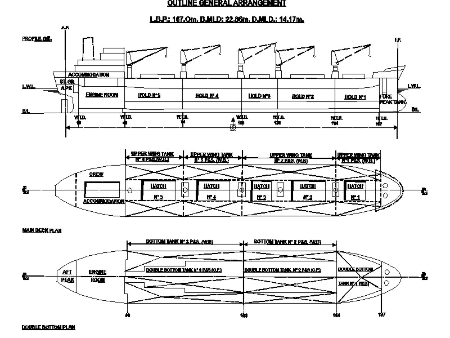
Appendix D— Glossary
- BRM
- bridge resource management
- CCG
- Canadian Coast Guard
- COG
- course over ground
- CSA
- Canada Shipping Act
- CTA
- Canadian Transportation Agency
- DGPS
- differential global positioning system
- Dw/d
- depth of water to draught ratio
- DWT
- deadweight ton
- ECDIS
- electronic chart display information system
- ECS
- electronic chart system
- ESP
- Enhanced Survey Program
- G
- gyro
- IMO
- International Maritime Organization
- ISM
- International Safety Management
- LPA
- Laurentian Pilotage Authority
- m
- metre
- MCTS
- Marine Communications and Traffic Services
- MOU
- memorandum of understanding
- MSI
- Marine Safety Information Letter
- NFU
- non-follow-up
- nm
- nautical mile
- Nm
- Newton/metre
- NOTSHIP
- notice to shipping
- NRT
- net registered ton
- OOW
- officer of the watch
- P
- port
- P&S
- port and starboard
- PSC
- Port State Control
- psi
- pounds per square inch
- r/min
- revolutions per minute
- RS
- Russian Maritime Register of Shipping
- S
- starboard
- SMS
- steering mode selector
- SOR
- Statutory Orders and Regulations
- SPI
- ship of particular interest
- SWBM
- still water bending moment
- t
- tonne
- t/m
- tonne/metre
- T
- true
- TC
- Transport Canada
- TCMS
- Transport Canada, Marine Safety
- trick wheel
- a small hand-operated wheel in the steering flat that can operate the rudder by acting directly on the telemotor receiver
- TSB
- Transportation Safety Board of Canada
- VHF
- very high frequency
- VTS
- Vessel Traffic Services
- °
- degree
- ′
- minute
- ″
- second