Collision with terrain
Arty’s Air Service Ltd.
Air Tractor, Inc. AT-502B, C-FJVL
Bawlf (Blackwells) Aerodrome (CFR2), Alberta, 18 NM S
The Transportation Safety Board of Canada (TSB) investigated this occurrence for the purpose of advancing transportation safety. It is not the function of the Board to assign fault or determine civil or criminal liability. This report is not created for use in the context of legal, disciplinary or other proceedings. See Ownership and use of content. Masculine pronouns and position titles may be used to signify all genders to comply with the Canadian Transportation Accident Investigation and Safety Board Act (S.C. 1989, c. 3).
History of the flight
On 12 September 2022, the pilot of the Arty’s Air Service Ltd. Air Tractor, Inc. (Air Tractor) AT-502B aircraft (registration C-FJVL, serial number 502B-3021) was planning to conduct a series of aerial application flights from Bawlf (Blackwells) Aerodrome (CFR2), Alberta. The pilot was met at the aerodrome by the mixer/loader at 0800.Footnote 1 They held a briefing of the day’s activity and then the mixer/loader added fuel and herbicide to the aircraft. At the time of takeoff, the aircraft had 117 U.S. gallons (½ tank) of fuel and 450 U.S. gallons of chemical mixtureFootnote 2 in the hopper tank.
At 0850, the occurrence aircraft departed CFR2 and proceeded 18 nautical miles (NM) south, to the field that was to be sprayed. After circling the field to inspect for hazards, the pilot sprayed the field in a consistent north–south pattern until the entire field had been sprayed. He then did 2 full east–west passes to cover off the ends of the field. All of the turns conducted during the application of chemical mixture were left turns and were consistent with altitude gains of ±300 feet above ground level (AGL). On the third-to-last turn in the middle of the field, the pilot conducted a right course reversal with a tight radius and a steep climb, resulting in an altitude increase of more than 500 feet AGL (Figure 1).
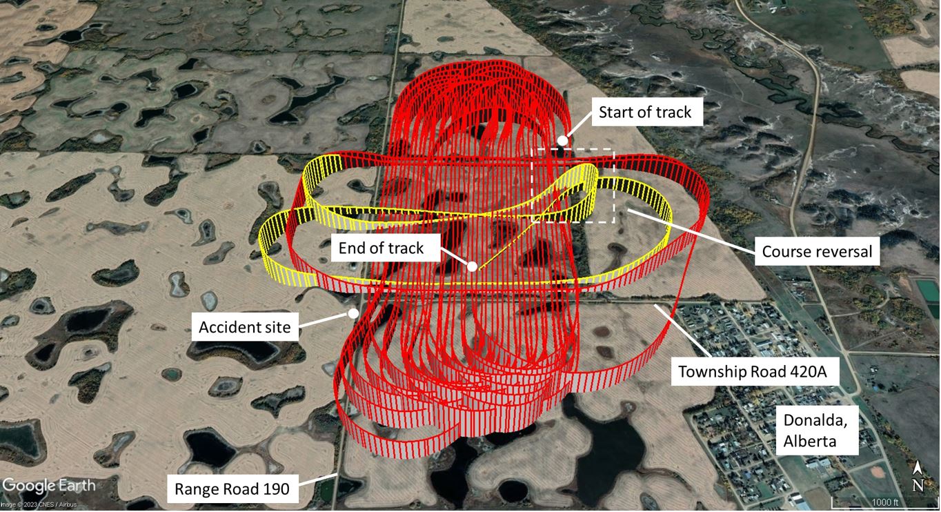
After this course reversal, the pilot did one more pass on the south end of the field followed by a large radius turn to the left and then descended and headed to the southwest corner of the field. An observer, who had been watching the entire field being sprayed from his vehicle parked mid-field on Township Road 420A, saw the aircraft pull up into what he considered the start of a normal climb on a westerly heading, just east of some power lines running on the east side of Range Road 190. The climb was then observed getting steeper than the previous climbs until the aircraft appeared to stop, the nose dropped, and the aircraft began to roll to the right. The aircraft struck the centre of Range Road 190, just south of the intersection with Township Road 420A, in a vertical, nose-down, attitude. The crash was not survivable. The aircraft was destroyed on impact. The emergency locator transmitter activated. There was no fire.
Pilot information
The pilot held an airline transport pilot licence and his Category 1 medical certificate was valid. His total flight time was 6190 hours. A review of his aerial application experience determined that he had over 2800 flight hours of aerial application experience on a variety of types of aircraft. He had over 600 hours on the Air Tractor AT-502B.
The pilot conducted aerial application flights for Arty’s Air Service Ltd. in the summer months from 2020 to 2022.
A review of the pilot’s activities in the days leading up to the accident indicated that he was well rested and that the operational pace was slowing down at the end of the aerial application season.
Aircraft information
The occurrence aircraft was an Air Tractor AT-502B single-seat, cantilever low-wing, all-metal aircraft with fixed conventional landing gear. It was powered by a Pratt & Whitney Canada PT6A-34AG engine.
The occurrence aircraft was manufactured in 2015 and was primarily used for agricultural aerial work. Its design was certificated in the United States in the restricted category,Footnote 3 and it was operated in Canada under a Special Certificate of Airworthiness with a restricted classification.
The Air Tractor AT-502B has a maximum take-off weight of 8000 pounds. The occurrence aircraft was operating with a Transport Canada-accepted supplement to the aircraft flight manual to operate at an increased gross weight of 10 170 pounds. The hopper, located between the cockpit and the engine, had a capacity of 500 U.S. gallons (1893 L). The fuel tanks were located in the wings with a total capacity of 234 U.S. gallons. The investigation determined that the aircraft weight was 5517 pounds at the time of the accident. The centre of gravity was in the middle of the weight and balance envelope.
The aircraft was equipped with an AG NAV GUIA Platinum precision GPS (global positioning system) navigation system, which was designed for aerial application operations. The AG NAV system featured a function that recorded data at 0.2-second intervals while spraying, and at 0.4-second intervals when not spraying. The unit wrote the data to an internal buffer (temporary memory) and then, after 8 seconds, the data was written to the non-volatile memory. When the aircraft impacted the ground, the last 8 seconds of the flight were lost because the power was cut off and the data had not yet been transferred to the non-volatile memory.
The investigation did not identify any technical malfunctions that could have prevented the aircraft from operating normally during the occurrence flight.
Company training
This was the pilot’s third season flying for Arty’s Air Service Ltd. He completed all recurrent training and ground school courses by May 2022. His most recent pilot competency check was carried out on 31 May 2022 and was valid at the time of the accident.
The company’s flight operations manual provides no guidance on bank angles and climb rates during course reversals other than to say that they must be done in accordance with the Canadian Aviation Regulations and the National Aerial Pesticide Application Manual.Footnote 4 Over the 2 flight days before the accident day, the aircraft’s AG NAV unit recorded the occurrence pilot performing multiple course reversals at low altitude with steep climbs and turns, which if coordinated, would have required bank angles in excess of 45°.
Impact and wreckage information
The aircraft was destroyed on impact. All major components of the aircraft were accounted for at the accident site. Based on the examination of the wreckage, the aircraft struck the ground in the middle of a rural gravel road in a vertical, nose-down, attitude (Figure 2). The bend signatures on the propeller blades indicate that the engine was developing power at the time of impact.
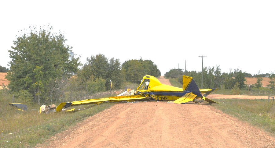
The leading edges of the wings had been flattened as they struck the road bed. The movement of fuel in the wing tanks caused hydroforming of the wing skins. The rivets attaching the upper wing skins sheared, rupturing the fuel tanks and allowing the fuel to spill. The empennage was relatively intact, but the vertical and horizontal stabilizers were bent forward. The parts that came off the aircraft during the impact were contained in the ditches on either side of the road, within a 65-foot radius of the point of impact.
Flight control systems were examined and found to be continuous. All fractures in the push-pull flight control tubes were attributed to overload during impact. The flaps were determined to be set to the 20° position. The aircraft systems were examined to the degree possible and no indications of a malfunction were found. There were no indications of a loss of control due to mechanical failure before impact.
Weather information
The nearest airport to the accident site with weather reporting was Red Deer Regional Airport (CYQF), Alberta, approximately 53 NM to the west-southwest. The 0900 aerodrome routine meteorological report at CYQF was as follows:
- wind from 340° true (T) at 4 knots
- visibility of 9 statute miles (SM)
- clear sky
- temperature 11 °C, dew point 7 °C
- altimeter setting 30.17 inches of mercury
The aerodrome forecast issued at 0540 indicated that conditions at CYQF at 0900 would be:
- wind from 340°T at 7 knots
- visibility greater than 6 SM
- few clouds at 10 000 feet and scattered clouds at 22 000 feet
Weather was not considered a factor in this accident.
Aerodynamic stalls
In order to sustain flight, an aircraft’s wing must create the required amount of lift. Lift is partly related to the speed of the aircraft and the angle of attack between the wing to the relative airflow. If speed is reduced, such as during a steep climb, the angle of attack must be increased to generate the required lift. An aerodynamic stall occurs when the wing’s angle of attack exceeds the critical angle at which the smooth airflow begins to separate from the wing. When a wing stalls, the airflow breaks away from the upper surface, and the amount of lift generated is reduced to below that needed to support the aircraft.
The speed at which a stall occurs can vary as it is also related to the load factor of the manoeuvre being performed. The load factor is defined as the ratio of the aerodynamic load acting on the wings to the aircraft’s gross weight, and represents a measure of the stress (or load) on the structure of the aircraft. By convention, the load factor is expressed in gFootnote 5because of the perceived acceleration due to gravity felt by an occupant in an aircraft.
In straight and level flight, lift is equal to weight, and the load factor is 1g. In a banked level turn, however, greater lift is required. It can be achieved, in part, by increasing the angle of attack (by pulling back on the elevator control), which increases the load factor. As the load factor increases with bank angle, there is a corresponding increase in the speed at which a stall occurs. As a result, the manoeuvre is often accomplished with the addition of engine power to maintain airspeed. A stall that occurs as a result of a high load factor, such as bank angle increased beyond 30°, is called an accelerated stall.
Accelerated stalls, which occur at higher airspeed due to the increased load factor on the wing, are usually more severe than unaccelerated stalls and are often unexpected. As an example, a stall from a 60° or 70° bank will result in an aggressive departure from controlled flight that will result in the aircraft rapidly losing altitude.
Safety message
Pilots are reminded that performing course reversals with steep climbs and bank angles greater than 45° increases the likelihood of an aerodynamic stall, which could lead to a spin. Encountering a stall or spin at low altitudes can result in a collision with terrain when there is insufficient altitude available to recover the aircraft.
This report concludes the Transportation Safety Board of Canada’s investigation into this occurrence. The Board authorized the release of this report on . It was officially released on .