Collision with cable
Privately registered
Bellanca 7GCBC (Citabria), C-GOQZ
Shawinigan, Quebec
The Transportation Safety Board of Canada (TSB) investigated this occurrence for the purpose of advancing transportation safety. It is not the function of the Board to assign fault or determine civil or criminal liability. This report is not created for use in the context of legal, disciplinary or other proceedings. See Ownership and use of content. Masculine pronouns and position titles may be used to signify all genders to comply with the Canadian Transportation Accident Investigation and Safety Board Act (S.C. 1989, c. 3).
History of the flight
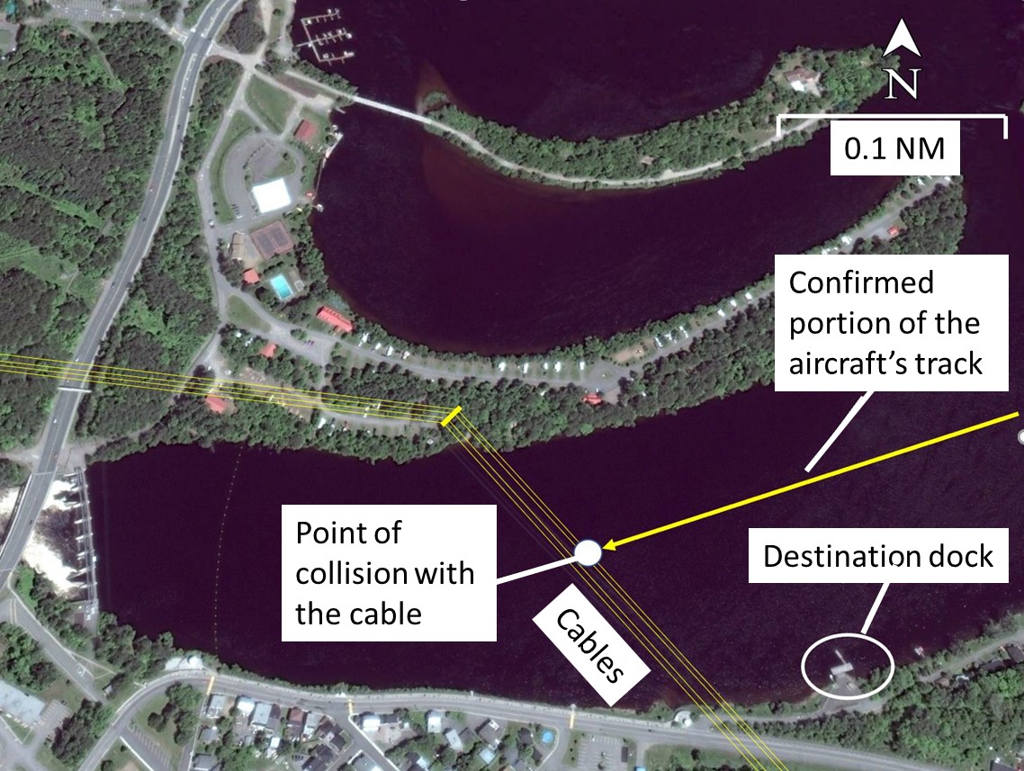
At approximately 1530Footnote 1 on 17 July 2022, the privately registered, float-equipped, single-engine Bellanca 7GCBC (Citabria) aircraft (registration C-GOQZ, serial number 74174) took off for a local visual flight rules (VFR) flight from Trois-Rivières Airport (CYRQ), Quebec, to Shawinigan, Quebec. The purpose of the flight was for the pilot, who was alone on board, to position his aircraft on the Saint-Maurice River, near downtown Shawinigan, for the summer season. Given that the aircraft was not equipped with amphibious floats, the departure from CYRQ was conducted by towing the aircraft on a trailer behind a pickup truck. Less than an hour after departure, the aircraft was seen flying over the Saint-Maurice River, from west to east, in Shawinigan. Approximately 10 minutes later, the aircraft was seen flying over the river once again, near the same location, but this time it was flying from east to west at low altitude, until it collided with the lower cable of a power line, which was at a height of about 20 m. After the impact, the aircraft fell into the river in an inverted position. The pilot was fatally injured.
Weather information
According to the aerodrome routine meteorological report (METAR) issued at 1500 for CYRQ, which is situated 10 nautical miles (NM) south-southeast of the accident site, the weather conditions were favourable for this VFR flight and were not considered to be a contributing factor in this accident.
Pilot information
The pilot held a Canadian private pilot licence – aeroplane, issued in July 2009, and a medical certificate which, according to Transport Canada (TC) records, had expired on 01 March 2020. The investigation was unable to determine whether the pilot had renewed his certificate after that date.
He had the ratings needed to fly single-engine landplanes and seaplanes. He had accumulated approximately 575 hours on the occurrence aircraft since he became the owner, in 2013.
Although the pilot was quite familiar with the Shawinigan area, this was the first time he was using this particular portion of the Saint-Maurice River to dock his aircraft.
According to information gathered during the investigation, there was no indication that the pilot’s performance was degraded by medical or physiological factors.
Aircraft information
The Bellanca 7GCBC (Citabria) is a single-engine 2-seat tandem aircraft that is commonly equipped with floats. At the time of the occurrence, the aircraft had accumulated about 2474.6 hours of air time, including approximately 1 hour for the occurrence flight. A review of the aircraft’s journey log and technical records did not reveal any outstanding defects that could have contributed to the occurrence. According to the wreckage examination, there was no indication that an aircraft system or component malfunction had contributed to this occurrence .
Accident site
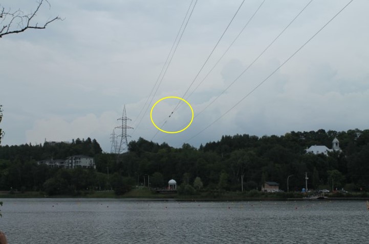
The accident occurred over the Saint-Maurice River in Shawinigan, not far from the destination dock, where a Hydro-Québec power line crosses the river, 3.5 NM west of a hydro dam. While flying over the landing site, the aircraft struck the lower cable on this power line (Figure 1).
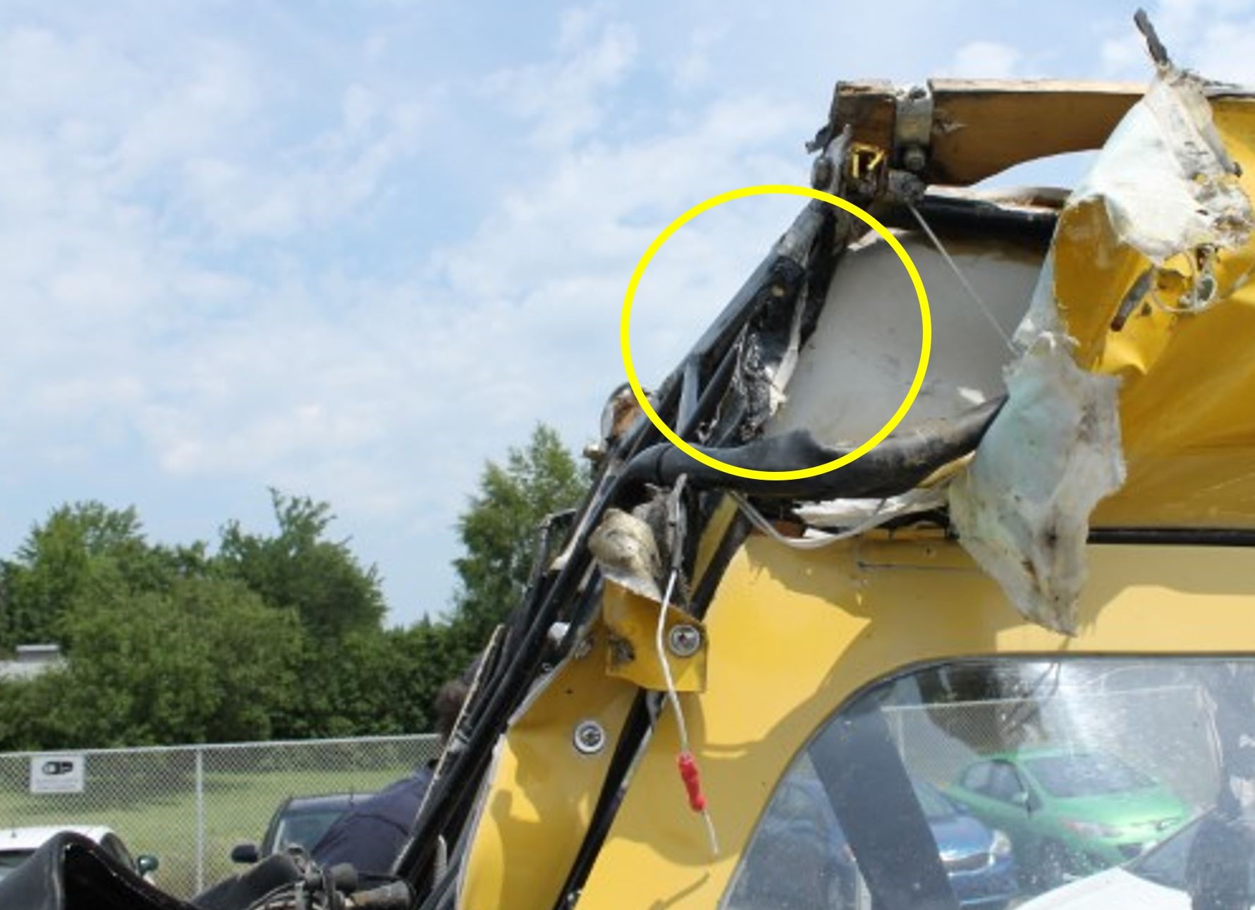
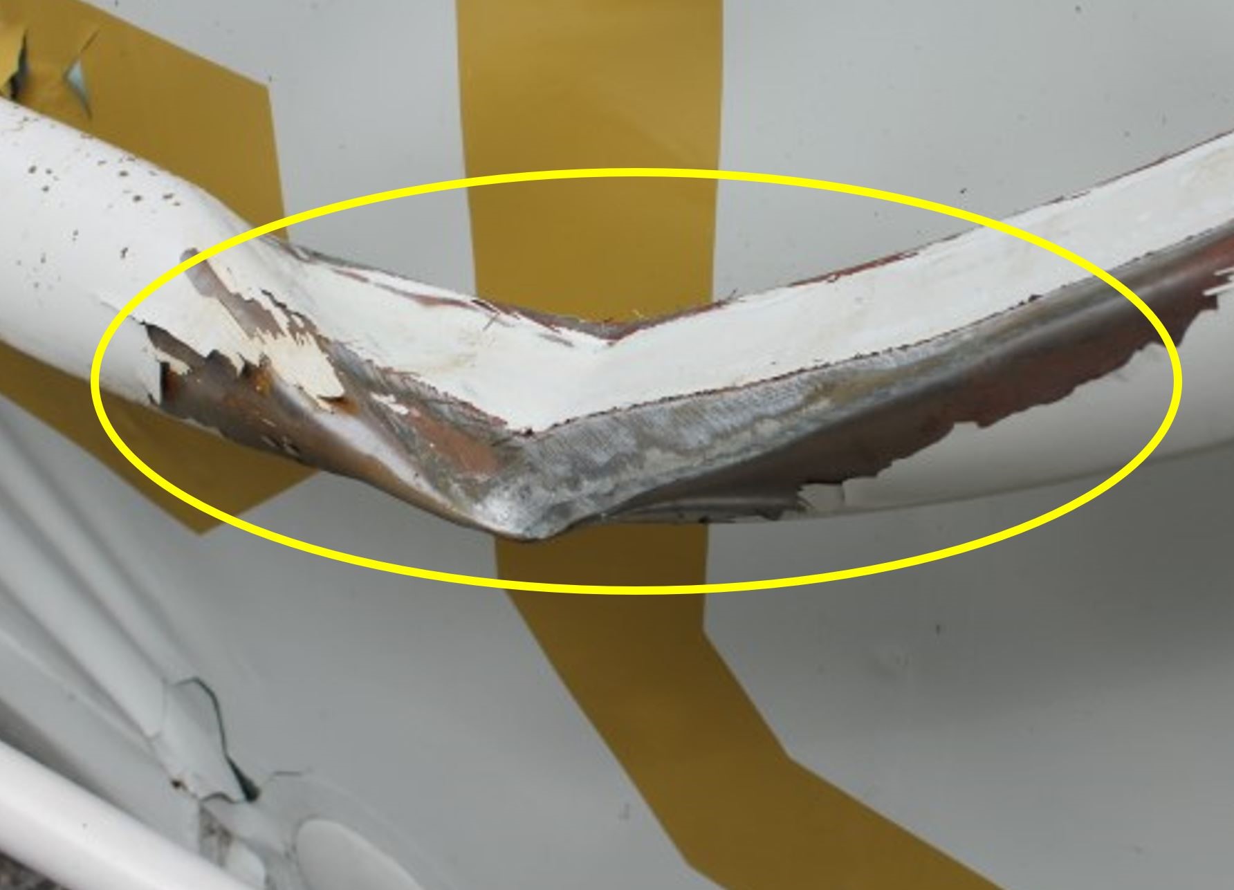
The damage to the lower cable matched the damage to the aircraft wreckage (Figure 2). Clear signs of contact with the cable were visible on the propeller blades, the left windshield post (Figure 3) and the left-wing strut (Figure 4).
Low-altitude flight
Intentionally flying at low altitude increases the risk of an accident: the pilot’s field of vision is reduced and consequently, the pilot has less time to take action to avoid obstacles and terrain. It is also recognized that flying at low altitude reduces the margin of safety in the event of engine failure, a loss of control, or any other unexpected circumstances, while increasing the risk of an impact with the ground or an obstacle. The Canadian Aviation Regulations (CARs)Footnote 2 and other publications make specific mention of these risks.Footnote 3,Footnote 4 Furthermore, over the years, the TSB has investigated numerous occurrencesFootnote 5 in which low-altitude flight was identified as a contributing factor.
Under certain circumstances and for a variety of reasons, a pilot may decide to fly over a point of interest on the ground at low altitude. For instance, the pilot may wish to inspect a planned landing area and the potential obstacles near a destination dock. If the pilot’s attention is fully focused on observing this point of interest on the ground, the pilot stops watching where the aircraft is heading and may not detect obstacles along the route.
Landing area inspection
When a pilot doubts the suitability of a site’s landing surface or does not have information about it in advance, “the area and surface must be visually inspected to provide sufficient information for the pilot to make the best decision on circuit, approach, and landing procedures.”Footnote 6
In its simplest form, this inspection, which is part of a procedure known as a precautionary landing, includes the following 2 parts:
- A normal circuit flown to a low approach over the intended landing site to visually inspect the potential landing area.
- Another normal circuit ending in a safe landing.Footnote 7
Among other things, this procedure allows the pilot to identify any obstacles, such as power lines. More specifically, in the case of a floatplane, TC’s Flight Training Manual stresses the importance of flying over the planned landing area to identify all obstacles such as boats, floating debris, and submerged obstacles. This overflight allows the pilot to not only identify all potential obstacles, but also to note watercraft positions and direction of motion.Footnote 8
More specifically, with regard to the inspection of landing surfaces, the Flight Training Manual states the following:
The inspection work associated with precautionary landings can be completed at low or high altitudes. If appropriate, both high and low passes provide their own important information.
Some pilots suggest that when both a high- and low-level pass are planned, the high pass should tell you about the particular flight path to follow. It should also let you identify any obvious reasons not to land at the location. Subsequent low-level passes must provide good reasons to land at the site. […]
When inspecting an unknown area in which there are numerous obvious obstacles, some pilots suggest a number of inspection passes at progressively lower altitudes to prevent encountering unexpected obstacles on an initial low pass.Footnote 9
Marking of obstacles to air navigation
Cables may be difficult to see during a flight. According to an article published in Flight Safety Australia, “[t]o a low-level flight crew, wire must [emphasis in original] be classified as an invisible hazard. […] A wire that is perfectly visible from one direction may be completely invisible from the opposite.”Footnote 10
The Transport Canada Aeronautical Information Manual (TC AIM) contains the following information regarding high voltage powerlines:
The line of structures of high voltage powerlines are easy to see, but when flying in their vicinity, pilots must take the time to look for what is really there and use safe procedures. The human eye has limitations, so if the background landscape does not provide sufficient contrast, pilots will not see a wire or cable. Although hydro structures are big and generally quite visible, a hidden danger exists in the wires between them.Footnote 11
According to subsection 601.24(2) of the CARs, marking and lighting are required for any building, structure, or object that constitutes an obstacle to air navigation.Footnote 12 The hydro towers at the occurrence site were no higher than 58 m (190 feet) above ground level (AGL), and the cables were lower than the top of the towers. Even though the cables were within 3.7 km of the centreline of a recognized VFR route — the St-Maurice River—,Footnote 13 according to the CARs,Footnote 14 they were not considered an obstacle because their height did not exceed 90 m (295 feet) AGL. The cables had no markers to make them more visible; these markers are not required when the height of the cables is 90 m (295 feet) AGL or less.
In general, power lines are indicated on VFR navigation charts (VNC) because they are useful landmarks that can facilitate visual navigation; however, portions of a power line may be deleted or hidden to make the chart clearer and easier to read. The occurrence power line did not appear on the relevant VNC (Montréal) and there were no regulations requiring that it appear on the chart.
Safety message
When inspecting an unknown landing area, pilots are encouraged to conduct a number of inspection passes at progressively lower altitudes to have a better chance at identifying obstacles such as cables, which may not be marked or indicated on charts, and can be extremely difficult to see.
This report concludes the Transportation Safety Board of Canada’s investigation into this occurrence. The Board authorized the release of this report on . It was officially released on .