Loss of control and collision with terrain
Privately registered
Piper Cherokee PA-28-140, C-GLKD
Sioux Lookout Airport, Ontario, 19 NM SSE
The Transportation Safety Board of Canada (TSB) investigated this occurrence for the purpose of advancing transportation safety. It is not the function of the Board to assign fault or determine civil or criminal liability. This report is not created for use in the context of legal, disciplinary or other proceedings. See Ownership and use of content. Masculine pronouns and position titles may be used to signify all genders to comply with the Canadian Transportation Accident Investigation and Safety Board Act (S.C. 1989, c. 3).
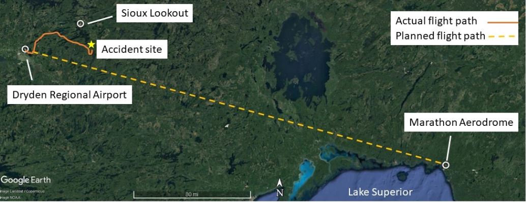
History of the flight
At 2102Footnote 1 on 29 April 2022, the privately registered Piper Cherokee PA-28-140 (registration C-GLKD, serial number 28-23807) departed Dryden Regional Airport (CYHD), Ontario, bound for Marathon Aerodrome (CYSP), Ontario, with 1 pilot and 3 passengers on board. The aircraft was reported overdue at 0139 on 30 April 2022. The aircraft had last been observed on radar at 2145,Footnote 2 flying a zig-zag route over an area with limited cultural lighting (Figure 1). A search was initiated and the wreckage was found approximately 19 nautical miles south-southeast of Sioux Lookout Airport (CYXL), Ontario. The aircraft had impacted terrain in a wooded area during the hours of darkness. The pilot and 3 passengers were fatally injured. The aircraft was destroyed. The emergency locator transmitter (ELT)Footnote 3 activated on impact and the signal assisted search and rescue services in locating the accident site.
Pilot information
The pilot held a commercial pilot licence, which had been issued on 18 September 2019. His licence was endorsed for single- and multi-engine aircraft. He held a valid Category 1 medical certificate. He did not have an instrument rating; therefore, he was not qualified for flight in instrument meteorological conditions (IMC).
In accordance with the Canadian Aviation Regulations (CARs), the holder of a pilot licence is required to have completed 5 night takeoffs and 5 night landings within the 6 months preceding the flight to fly an aircraft with passengers on board at night.Footnote 4 The investigation reviewed the pilot’s logbook and did not identify any night flight entries in the 6 months preceding the accident.
The passenger who was seated in the front right seat also held a commercial pilot licence.
Aircraft Information
The occurrence Piper PA-28-140 was manufactured by the Piper Aircraft Corporation in 1967. It was a single-engine, all-metal, low-wing aircraft, equipped with fixed tricycle landing gear. It was configured to carry 4 passengers and was certified for a maximum take-off weight of 2150 pounds. The aircraft weight at the time of the occurrence was calculated to be approximately 2320 pounds, which is 170 pounds over the aircraft’s maximum take-off weight.
The aircraft was privately registered and maintained on an annual inspection program as specified in CARs Standard 625.86, Appendix B, Part I. The aircraft had undergone a 50-hour inspection on 08 March 2022 and had a total airframe time of 4467 hours at the time of the occurrence.
The aircraft was originally equipped with a 150 hp Lycoming O-320-E2A carbureted engine. In March 2019, the engine and aircraft were modified to achieve an increased take-off power rating of 160 hp, under the authority of Supplemental Type Certificate numbers SE8987SW-D and SA2706SW-D, respectively.
A review of the aircraft technical records did not reveal any outstanding defects that may have contributed to the occurrence.
Impact and wreckage information
The aircraft struck trees in a heavily wooded area approximately 19 nautical miles south-southeast of Sioux Lookout, Ontario. The investigation determined that the aircraft entered the forest canopy in a 90° angle of bank, indicating that it had departed controlled flight. The aircraft came to rest approximately 100 feet from where it initially came into contact with trees. There was no post-impact fire.
The airframe broke apart in a manner consistent with a cartwheeling motion, and both fuel cells ruptured. Analysis of the aircraft components did not reveal any pre-existing anomalies and the engine was determined to have been operating normally. An inspection of the carburetor heat selector was inconclusive due to the nature of the impact damage. While the investigation did not reveal any signs of carburetor icing, the local weather conditions were consistent with those that could produce carburetor icing.Footnote 5 Damage to the flight controls were consistent with overload failures, also a result of the impact.
Weather information
The graphic area forecast for the area around CYHD and CYXL, issued at 1825 on 29 April and valid at 1900, called for broken cloud layers with bases at 4000 feet above sea level (ASL) and tops at 12 000 feet ASL, visibility greater than 6 statute miles (SM), isolated altocumulus castellanus clouds topping at 16 000 feet ASL with visibility of 5 SM in light rain showers and fog, and ceilings of 1500 feet above ground level (AGL) (Figure 2).

The aerodrome forecast (TAF) for CYHD, issued at 2040 on 29 April, indicated the following:
- From 2100 on 29 April to 0900 on 30 April:
- Wind from 120° true (T) at 8 knots
- Visibility greater than 6 SM in light rain
- Scattered cloud layer at 2000 feet AGL and overcast ceiling at 4000 feet AGL
- Temporarily during the same time period:
- Visibility greater than 6 SM in light rain showers
- Overcast ceiling at 2000 feet AGL
The TAF for CYXL, issued at 2040 on 29 April, indicated the following:
- From 2100 on 29 April to 0900 on 30 April:
- Wind from 160°T at 8 knots
- Visibility greater than 6 SM
- Scattered cloud layer at 2000 feet AGL and overcast ceiling at 4000 feet AGL
- Temporarily during the same time period:
- Visibility greater than 6 SM in light rain showers
- Broken ceiling at 2000 feet AGL, overcast cloud layer at 4000 feet AGL
The aerodrome routine meteorological report (METAR) for CYXL issued at 2200 was:
- Wind from 110°T at 5 knots
- Visibility 15 SM in light rain
- Overcast ceiling at 3000 feet AGL
- Temperature 4 °C, dew point 0 °C
- Altimeter setting 30.05 inches of mercury (inHg)
At 2050, the pilot called the NAV CANADA Flight Service Station to file a flight plan. During the call, the flight service specialist provided an abbreviated weather briefing, and indicated that marginal visual flight rules (VFR) weather could be present on the proposed route of flight.
Night visual flight
Flying VFR at night involves numerous risks owing to poor visual cues. The fact that there are few or no visual references at night can lead to various illusions causing spatial disorientation due to the lack of discernible horizon. A night VFR flight that is conducted beneath an overcast ceiling, without moonlight, over areas with featureless terrain, such as bodies of water or forest, and away from cultural lighting provides inadequate ambient illumination for visual reference to the surface. These areas are referred to as black holes; flying over them is difficult.
In addition, estimating distance from cloud and adverse weather at night or in darkness is difficult for pilots and increases the risk of inadvertent VFR flight into IMC, which can quickly result in spatial disorientation and a loss of control.
Simply put, night VFR flight inherently offers the pilot limited visual cues to be able to see and avoid worsening weather conditions. Flight planning is especially important for night flights, specifically: a review of weather conditions and their corresponding impact on the intended aircraft track, the available moonlight, the estimated flight time over large bodies of water or areas with little or no cultural lighting, and the intended flight track’s proximity to rising terrain and significant obstacles.
The principle behind VFR flight is that the pilot uses visual cues (e.g., visual horizon, ground references) outside the aircraft to determine the aircraft’s attitude. Therefore, some basic requirements must be met when conducting VFR flight—day or night.
According to sections 602.114 and 602.115 of the CARs, the aircraft must be “operated with visual reference to the surface,”Footnote 6 regardless of whether it is operated in controlled or uncontrolled airspace. The CARs define surface as “any ground or water, including the frozen surface thereof.”Footnote 7 However, the term “visual reference to the surface” is open to interpretation, because it is not defined in the regulations. Industry has widely interpreted it to mean visual meteorological conditions (VMC).Footnote 8,Footnote 9 Following a TSB investigationFootnote 10 into a helicopter accident in May 2013, the Board recommended that
[t]he Department of Transport amend the regulations to clearly define the visual references (including lighting considerations and/or alternate means) required to reduce the risks associated with night visual flight rules flight.
TSB Recommendation A16-08Footnote 11
The conditions experienced during the occurrence flight were such that visual reference to the surface likely was difficult to maintain, and therefore the flight would not have met the requirements for operation under night VFR. Instead, such a flight would require pilots to rely on their flight instruments to ensure safe operation of the aircraft. Neither the pilot nor the passenger seated in the front right seat, who both held a commercial pilot licence, was certified for IFR flight.
TSB laboratory reports
The TSB completed the following laboratory reports in support of this investigation:
- LP047/2022 – NVM Recovery – iPad
- LP053/2022 – NVM Recovery – Digital Instruments
Safety messages
Continued flight under night VFR into areas with reduced visual cues, such as areas with limited cultural lighting or deteriorating weather, can lead to spatial disorientation and a loss of control. All pilots—no matter how experienced they are—need to plan ahead and consider strategies to avoid such conditions, as well as have alternate plans should such conditions be encountered.
This report concludes the Transportation Safety Board of Canada’s investigation into this occurrence. The Board authorized the release of this report on . It was officially released on .