Controlled flight into terrain
de Havilland DHC-2 MK 1 (Beaver) C-GCZA
Peachland, British Columbia, 10 nm W
The Transportation Safety Board of Canada (TSB) investigated this occurrence for the purpose of advancing transportation safety. It is not the function of the Board to assign fault or determine civil or criminal liability. This report is not created for use in the context of legal, disciplinary or other proceedings. See Ownership and use of content. Masculine pronouns and position titles may be used to signify all genders to comply with the Canadian Transportation Accident Investigation and Safety Board Act (S.C. 1989, c. 3).
Summary
The privately operated de Havilland DHC-2 MK 1 amphibious floatplane (registration C-GCZA, serial number 1667) departed Okanagan Lake, near Kelowna, for a daytime flight under visual flight rules to Pitt Meadows, British Columbia, with the pilot and 2 passengers on board. While enroute, the aircraft struck trees and collided with terrain close to and 100 feet below the level of Highway 97C, near the Brenda Mines tailings hill. At 1850 Pacific Daylight Time, a brief 406-megahertz emergency-locator-transmitter signal was detected, which identified the aircraft; however, a location could not be determined. Most of the aircraft was consumed by a post-impact fire. The 3 occupants were fatally injured
Factual information
History of the flight
The amphibious aircraft departed on wheels from Pitt Meadows Airport, British Columbia, at 1620,Footnote 1 with the pilot and 3 passengers on board, for a daytime visual flight rules (VFR) flight to Okanagan Lake, British Columbia. It arrived on Okanagan Lake 1.6 hours later. After spending 20 minutes on the water and dropping off 1 passenger, the aircraft departed southbound toward Peachland.
Although not required to do so, the pilot contacted the Kelowna air traffic control (ATC) tower and informed the controller of intentions to gain altitude over the lake southbound, then northbound, before turning westbound for the return flight to Pitt Meadows. The occurrence aircraft did not show up on the Kelowna ATC radar system, as aircraft have to be above 4500 feet above sea level (asl) to be visible on radar in that area.
At 7.7 nautical miles (nm) from the accident site, the aircraft was flying westbound up the valley, at an estimated altitude of 2600 to 2900 feet asl.
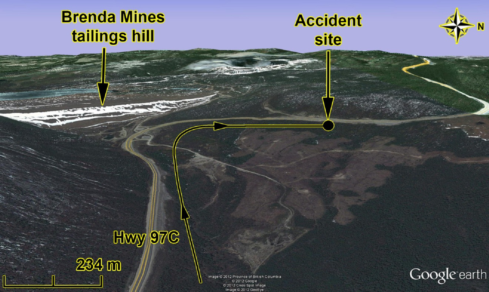
Highway 97C has a steep uphill grade westbound as it climbs out of the Okanagan Valley. The highway then turns right (northbound) at the base of the Brenda Mines tailings hill, and continues to climb steeply (Figure 1).
From Highway 97C, passing motorists observed the occurrence aircraft climbing and turning to follow the highway.
Reaching the bend in the highway at the bottom of the Brenda Mines tailings hill, the aircraft was flying below the level of the highway and close to it in a climb, when it started a right turn to the north, and continued climbing. The aircraft remained below the highway and just about parallel to it. The aircraft struck trees on a small knoll that rises slightly above the surrounding terrain, which slopes into the valley to the right of the flight path. The impact was not witnessed, as there were trees obscuring the view from the highway. A column of rising smoke was observed, and 911 was notified of the suspected accident.
The period of flight from the turn at the bottom of the Brenda Mines tailings hill to the occurrence site was approximately 24 seconds. To the right of the occurrence aircraft's track along the highway, the terrain sloped down the valley toward lower elevations.
Weather information
Twenty minutes after the accident, a Royal Canadian Mounted Police (RCMP) helicopter en route from Kelowna encountered 10- to 15-knot headwinds, down-flowing air, and turbulence as it was flying westbound up the valley on the way to the accident site. The sun was low on the horizon (mountaintops) and impaired forward vision dramatically.
Using data from nearby weather stations at Brenda Mines and the British Columbia Highways Pennask Summit, the density altitude was estimated to be 5289 feet or greater at the 4307-feet—asl accident site. The temperature was dropping as the sun set, and was calculated to be 15°C. The wind at Brenda Mines was reported by the RCMP helicopter as being from the northwest at 3 knots, resulting in some down-flowing air at the accident site.
Flight crew
Records indicated that the pilot was certified and qualified for the flight in accordance with existing regulations. An experienced Beaver pilot had given the accident pilot 12 hours of dual instruction during the winter and spring of 2012, all at sea level. The accident pilot had accumulated a total of approximately 50 hours in the accident aircraft, and approximately 420 hours of total flight time.
The pilot had taken a mountain-flying course 10 years previously, with a local flying club. It could not be determined what the curriculum of this training included, due to the length of time since that training had been obtained. Transport Canada does not require mountain-flying training, nor does it set standards for mountain-flying training courses.
Aircraft
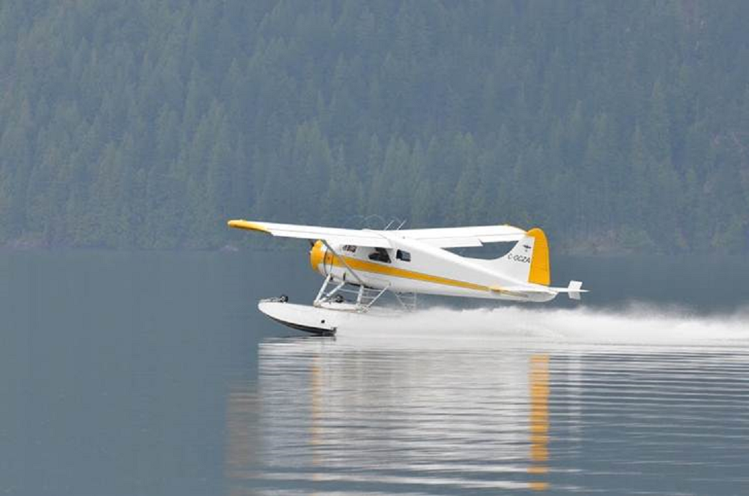
The de Havilland DHC-2 MK 1 amphibious floatplane, commonly known as a Beaver, was registered to the pilot/owner in June 2011. The Beaver is a single-engine, piston aircraft that is used widely in bush-flying operations. It can be used on wheels, skis, or floats, or in amphibious (wheels/floats) configuration (Photo 1).
Records indicated that the aircraft was certified, equipped, and maintained in accordance with existing regulations and approved procedures.
The aircraft was not equipped with on-board recorders, nor were they required by regulation. Without recorders, it was difficult to confirm the sequence of events that led to the accident.
The aircraft was equipped with an emergency locator transmitter (ELT), transmitting on the 406-megahertz frequency. The COSPAS-SARSATFootnote 2 system received a brief ELT signal, which permitted the system to identify the signal as being from C-GCZA, but which was not long enough for the system to determine the position of the aircraft. The ELT was completely consumed by the fire.
On the day of the accident, the aircraft was fuelled at Pitt Meadows Airport, where it was based. The 3 fuel tanks in the belly of the fuselage were filled to maximum capacity. The tip tanks, which hold a maximum of 18 imperial gallons each, were partially filled. It could not be determined exactly how much fuel was carried in these tanks. The aircraft is not approved to land with fuel in the tip tanks.
No record of a pre-departure weight-and-balance calculation was found for the occurrence flight. The investigation determined that the aircraft was operating within its maximum gross weight and centre-of-gravity limits; however, the aircraft was near its maximum certified gross weight at the time of the accident.
The pilot/owner of the accident aircraft also owned a Cessna 182 on amphibious floats. The Cessna 182 was modified with an engine that produced 30 horsepower (hp) more than the 230 hp of the one originally installed on the aircraft. Performance figures are not available for the modified Cessna 182. Owners of Cessna 182s with this type of modification, regardless of the increase in performance, are directed to use original manufacturer's performance figures.
A performance-figures exercise was conducted by the Transportation Safety Board (TSB) using original manufacturer's performance charts.
The Beaver performance figures indicate that the rate of climb for a Beaver on wheels, at maximum continuous power and at 5000 feet on a standard day, should be 795 feet per minute.Footnote 3 The climb rate for a Beaver on floats, under the same conditions, should be 685 feet per minute, or 86% of the climb rate for a Beaver on wheels.
To reduce engine wear, the engine manufacturer for the Beaver recommends that 2000 revolutions per minute (rpm) and 30 inches of mercury (in. Hg) be used for climb-power setting. This power setting is lower than the normal setting, resulting in a reduced rate of climb.
The original Cessna 182 performance figures indicate that the rate of climb for the Cessna 182 on wheels, at maximum continuous power, and at 5000 feet on a standard day, should be 950 feet per minute. There are no performance figures for the Cessna 182 on floats, but if the same 86% is applied as for the Beaver, a climb-rate figure of 817 feet per minute is obtained.
The Cessna 182 had a higher climb rate than the Beaver. The pilot had flown the route from Pitt Meadows to Kelowna and return many times over the previous 10 years in the Cessna 182. The accident flight was the first time on that route in the Beaver. Due to the difference in climb performance between the 2 aircraft, it is believed that the Beaver would be much lower than the Cessna 182 at this point in the journey. Based on the fact that the Cessna 182 could out-climb the Beaver by at least 100 feet per minute, and given that the Beaver flight was 26 minutes long, the Cessna 182 would have been able to climb to an altitude approximately 2600 feet higher than the Beaver, given the same ground track, if continually climbing during the flight.
Wreckage information
The investigation determined that the path of the aircraft through the trees was 345° magnetic, and 292 feet in length. The first impact mark was a small treetop that had been broken by the left wing. Nineteen feet further along the path, the right wing had broken a small treetop. These 2 trees were 36 feet apart, and measured 90° to the path. The wing span of the Beaver is 48 feet. The wings were likely between level and 3° right-wing low when the aircraft struck the trees. The next strike of significance was closer to the centreline of the path and considerably lower; it was a large broken tree trunk. It was determined that the floats had struck this tree. The difference in heights was attributed to the height of the wings above the floats. At that point, the aircraft was likely between near-level flight and a 4° climb.
The aircraft then continued breaking through the trees, and began descending. The left wingtip was torn off at 155 feet down the path. (The tree trunk it struck was scarred but not broken, and the wingtip was intact, with no evidence of fire.) At 238 feet, after 3 more tree strikes, the aircraft struck and broke a 12-inch-diameter tree. At 240 feet down the path, the propeller vertically sliced a section of a 7-inch-diameter lodgepole pine tree at 44 feet above ground level (agl), and broke the top off. The investigation determined that the damage was consistent with a propeller strike under power. One wing broke, and the aircraft rolled about its longitudinal axis and descended at close to a 45° angle, colliding with the rising terrain while inverted. A post-impact fire consumed most of the aircraft, except for 8 feet of the empennage.
Visual illusion
Illusions give false impressions or misconceptions of actual conditions; therefore, pilots must understand the types of illusions that can occur and the resulting disorientation they could experience. Although the visual system is the most reliable of the senses, some illusions can result from misinterpreting what is seen; what is perceived is not always accurate. Even with the references outside of the aircraft and the display of instruments inside, pilots must be on guard to interpret information correctly.
Several previous investigations of accidents in mountainous regions have documented visual illusions that occur while flying at low levels through valleys, and are quoted below:
- “An illusion creates a false perception that may be described as a form of spatial disorientation regarding terrain.”Footnote 4
- “The characteristics of the terrain were deceptive, making it difficult for the pilots to perceive their proximity and rate of closure to the rising ground in sufficient time to avoid it.”Footnote 5
- Additionally, an investigation conducted by the Canadian Forces Directorate of Flight Safety into the crash of a military DHC-6 Twin Otter in Alberta (no. 13807) concluded that visual illusion was a principal contributing factor.
The Aeromedical Training for Flight Personnel manualFootnote 6 includes the following information:
Spatial Disorientation TYPE I (UNRECOGNIZED) − A disoriented aviator does not perceive any indication of spatial disorientation. In other words, he does not think anything is wrong. What he sees—or thinks he sees—is corroborated by his other senses. Type I disorientation is the most dangerous type of disorientation. The pilot—unaware of a problem—fails to recognize or correct the disorientation, usually resulting in a fatal aircraft mishap:
- The pilot may see the instruments functioning properly. There is no suspicion of an instrument malfunction.
- There may be no indication of aircraft-control malfunction. The aircraft is performing normally.
- An example of this type of spatial disorientation would be the height /depth-perception illusion when the pilot descends into the ground or some obstacle above the ground because of a lack of situational awareness.
The TSB Laboratory completed a shadow analysis of the accident site and area for the time and date of the accident. It was determined that the accident site would have been in shadow. The impact site is on a small knoll that rises slightly above the slope of the surrounding terrain, which all slopes down into the valley to the right of the flight path.
A Canadian university with expertise in ophthalmology was consulted. Using the TSB shadow analysis report and its knowledge in the subject, the university determined that, in addition to flash blindnessFootnote 7 from the direct sunlight, disability glare from the continuous exposure of the sunlight in the peripheral field would have likely played a significant role in this occurrence.
Disability glare is explained as follows:
When there is a strong light source in the field of view, it appears as though a veil of light has been thrown over the world outside. Close to the light source, we may be almost completely blind but further away, visual performance can be notably hampered. This experience, well known to drivers, is usually called glare or, to be more precise, disability glare.Footnote 8
Controlled flight into terrain
In June 2012, the TSB released its Watchlist identifying the safety issues investigated by the TSB that pose the greatest risk to Canadians. One of the safety issues identified was controlled flight into terrain (CFIT). CFIT accidents occur when an airworthy aircraft, while under the control of the pilot, is inadvertently flown into the ground, water, or an obstacle. In these cases, pilots are unaware of the danger until it is too late. This type of accident often happens when visibility is low, at night, or during poor weather. Such conditions reduce a pilot's situational awareness of surroundings, and make it difficult to tell whether the aircraft is too close to the ground. The risk is even greater for small aircraft, which venture further into remote wilderness or into mountainous terrain, but are not required to have the same ground-proximity warning equipment as large airliners.
According to the Watchlist, “between 2000 and 2009, there have been 129 accidents of this type in Canada, resulting in 128 fatalities.”Footnote 9 CFIT accounted for 5% of the accidents, but nearly 25% of all fatalities.
Similar accidents
Other accidents involving aircraft that departed the Okanagan Valley experienced similar density-altitude and visibility issues.Footnote 10
As well, on 13 August, 2012, 3 months after this accident, a Piper PA-30 departing Penticton Airport for Boundary Bay Airport, British Columbia, turned west and subsequently crashed at 4595 feet asl, only 1.03 nm from where the Beaver had crashed.Footnote 11
Departure procedures
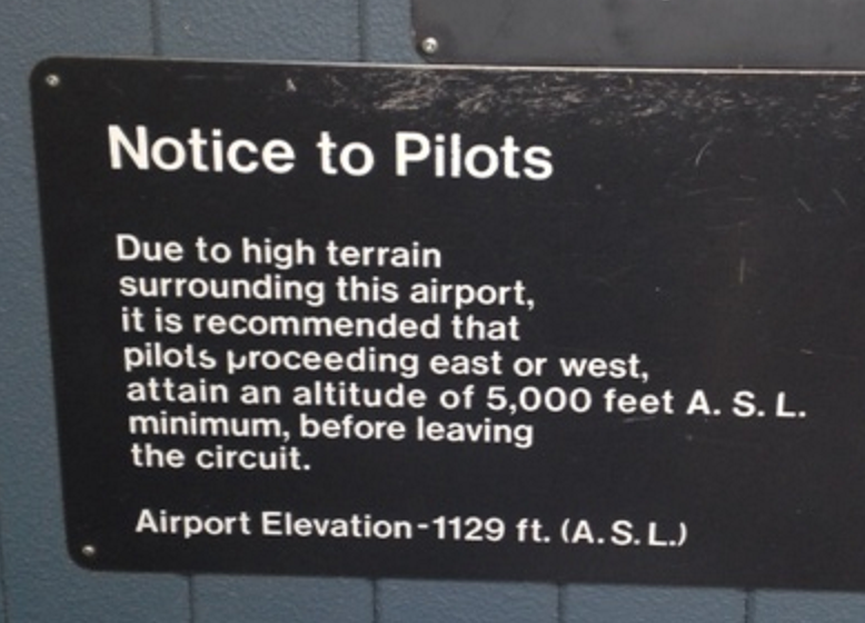
A sign located on the airside wall beside the door to the pilots' information kiosk at Penticton Airport, 30 nm from Kelowna and at the south end of Okanagan Lake, warns pilots about the high terrain in the area and the importance of reaching 5000 feet asl before leaving the circuit (Photo 2).
The Canada Flight Supplement, which contains information on Canadian and North Atlantic aerodromes and is used as a reference for planning and safe conduct of air operations, provides no special departure procedure for either Penticton Airport or Kelowna Airport, and is not required to do so. It does however, include special procedures for night flying, and has clear depictions and warnings of the high terrain in the area.
The VFR navigation chart (VNC), which is used by VFR pilots on short to extended cross-country flights at low to medium altitudes and at low to medium airspeeds, displays aeronautical information and sufficient topographic detail to facilitate air navigation through the use of a unique color scheme, layer tinting, and shaded relief. There are, however, no warnings on the Vancouver VNC about climbing to 5000 feet asl before turning east or west to depart the Okanagan Valley.
No notice to airmen (NOTAM) regarding special departure procedures was in effect at the time of the accident.
NAV CANADA
In addition to not being visible on radar, the occurrence aircraft was not visible on a new Wide Area Multilateration (WAM) system that was being tested by NAV CANADA in the vicinity of Kelowna. Multilateration (MLAT) can provide surveillance coverage in areas where it is not possible or is too costly to install radar. The WAM is a system of ground stations that receive signals from aircraft transponders to determine aircraft position. NAV CANADA could not provide WAM data for aircraft outside of the Kelowna control zone. NAV CANADA initially indicated that data outside the confines of the Kelowna control zone were filtered out before being displayed and recorded.
It was later discovered that the unfiltered MLAT data were actually available for approximately 72 hours after capture, after which time the data would have been overwritten. In order to retrieve the WAM data, a technician would have had to be dispatched to the WAM main site. However, local NAV CANADA personnel were not aware that the unfiltered data had been available for a limited time period, and as a result, these useful data were not preserved.
TSB Laboratory reports
The following TSB Laboratory reports were completed:
- LP 100/2012 − Shadow Analysis
- LP 105/2012 − Manifold Pressure Gauge Examination
These reports are available from the Transportation Safety Board of Canada upon request.
Analysis
There was no indication that an aircraft system malfunction contributed to this occurrence. There were no drastic changes in the aircraft's flight path, and no emergency calls from the pilot to indicate that an in-flight emergency was experienced. The constant ground speed and flight path would also suggest that the aircraft was under the control of the pilot. As a result, this analysis will focus on the phenomenon of controlled flight into terrain (CFIT).
As forward visibility was likely hindered due to the aircraft heading toward the sun, the pilot was likely following the highway by looking out of the left window. The pilot's vision was likely subjected to flash blindness, due to flying westbound into the setting sun. When turning northbound, the pilot was probably still affected by disability glare, and possibly by a visual illusion. Being in shadow, the treetops were probably not visible until the aircraft made contact with them.
While operating close to maximum gross weight, at a higher density altitude, and with some down-flowing air, the aircraft's climb performance would have been reduced from what the pilot would have encountered at sea level in cooler temperatures, or in the Cessna 182. Due to the difference in climb performance between the Cessna 182 and the Beaver, it is likely that the Beaver was much lower than the Cessna 182 would have been at this point in the flight.
The aircraft was below the level of the highway, and an open valley was available, with a slight turn to the right. Given that the aircraft was under power at impact, a forced or precautionary landing on the highway was likely not being attempted.
In summary, the aircraft's performance was limited by weight, density altitude, and some down-flowing air. At the same time, the pilot's vision was impaired by the sun, and the pilot may have been exposed to visual illusions; both were factors that contributed to the pilot not noticing the rising terrain, and colliding with it.
There is no visual flight rules (VFR) special departure procedure published for airports in the Okanagan Valley. At the time of the occurrence, the only clear warning or indication of such a procedure was a sign at Penticton Airport warning pilots heading east or west not to leave the circuit until reaching a minimum of 5000 feet above sea level (asl). If pilots do not proceed by the door where the sign is located, are on a transit stop to another airport, or are operating from another airport in the Okanagan Valley, they would not see the sign. If no other warnings are available, there is a risk that pilots may leave the circuit at an altitude too low for terrain clearance outside the Okanagan Valley.
In this occurrence, data from NAV CANADA's new Wide Area Multilateration (WAM) system, which was being tested, were not retained. As a result, useful information that could have assisted the investigation was not available.
Findings
Findings as to causes and contributing factors
- The combination of relatively high weight, effects of density altitude, and down-flowing air likely reduced the climb performance of the aircraft, resulting in the aircraft's altitude being lower than anticipated at that stage in the flight.
- The pilot's vision was likely impaired by the sun, and the pilot may have been exposed to visual illusions; both were factors that contributed to the pilot not noticing the trees and the rising terrain, and colliding with them.
Findings as to risk
- Visual illusions cause false impressions or misconceptions of actual conditions. Unrecognized and uncorrected spatial disorientation, caused by illusions, carries a high risk of incident or accident.
- When there are no special departure procedures published for airports in mountainous regions surrounded by high terrain, there is a risk of pilots departing the valley at an altitude too low for terrain clearance.
Other findings
- Information from the Wide Area Multilateration system was not preserved following the occurrence, as local NAV CANADA personnel were not aware that unfiltered data were only available for a limited time.
Safety action
Safety action taken
NAV CANADA
NAV CANADA has issued a Canada Flight Supplement amendment for the Penticton, Oliver, and Osoyoos airports in the Okanagan Valley. The following warning has been added to the caution sections of these airports:
“Due to high terrain, it is recommended pilots proceeding E or W under VFR , maintain an alt of 5,000 feet (ASL) min before leaving the Okanagan Valley.”
The next available edition of the NAV CANADA Vancouver visual flight rules (VFR) navigation chart (VNC) includes the new VFR route, as suggested by Transport Canada, between Princeton, Brenda Mines and Highway 97C to Okanagan Lake. An associated caution reads as follows:
−CAUTION−
VFR ROUTE VALLEY FLOOR HAS STEEP GRADIENT TO 4500 FEET ASL WITHIN 10NM OF OKANAGAN LAKE
This edition of the VNC , no. 25, is planned for August 2013.
Penticton airport
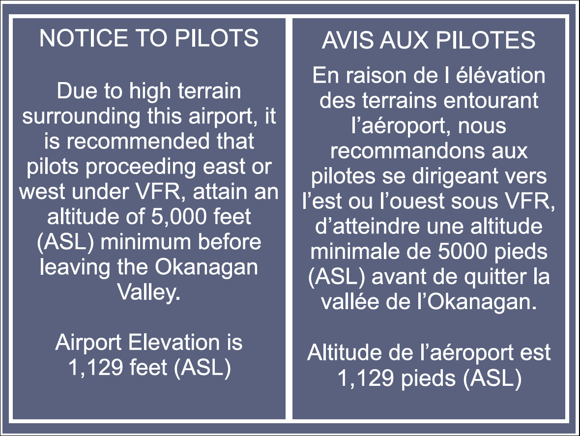
The sign at Penticton Airport has been modified as per Figure 2:
This report concludes the Transportation Safety Board's investigation into this occurrence. Consequently, the Board authorized the release of this report on . It was officially released on .