Associated links (A98H0003)
-
Table of contents
- General
- Area forecast
- Additional terminal aerodrome forecasts
- Additional METARs
- Winds and temperatures aloft in the Halifax area
- Significant meteorological information
- Pilot weather reports
- Thunderstorms
- Lightning
- Weather information received from British Airways Flight 214 (Speedbird)
- Weather requested by flight crew via ACARS
- Pre-flight briefing
- Weather observed on the ground in the vicinity of Peggy's Cove
- Weather observed in the air in the Halifax area
- Other information
- Turbulence
- Icing
- Instrument meteorological conditions
Meteorological conditions
General
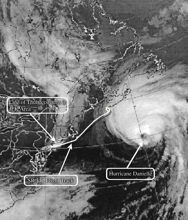
At 0000 on 3 September 1998, Hurricane Danielle was located approximately 300 nm southeast of Halifax. Nova Scotia was under the influence of a weak ridge of high pressure and the distant effects of the hurricane. The other active weather system near the flight track of SR 111 was a line of thunderstorms moving through the New York area. The forecast effects of both systems were moving in a predictable manner.
It is likely that SR 111 was avoiding the thunderstorm that was reported overhead the airport at 0010 just after departure. If the line of thunderstorms were moving eastward at 30 knots, then the thunderstorm would have been 4 to 5 nm east of the airport at the time of departure. A satellite image depicts the meteorological conditions 47 minutes prior to the accident.
Area forecast
For the geographical area of eastern New York, the FAUS5 for the FA1W issued at 1745 on 2 September 1998 and valid until 1200 on 3 September 1998, predicted scattered clouds at 4 000 feet, broken clouds at 8 000 feet, layered clouds up to 18 000 feet, widely scattered, light rain showers or thunderstorms with light rain (the thunderstorms possibly severe), and cumulonimbus clouds with tops at 40 000 feet. The updated FA1W issued at 0045 on 3 September 1998 predicted broken clouds at 4 000 to 6 000 feet with tops at 18 000 feet, widely scattered, light rain showers, isolated thunderstorms with light rain, and cumulonimbus clouds with tops at 40 000 feet.
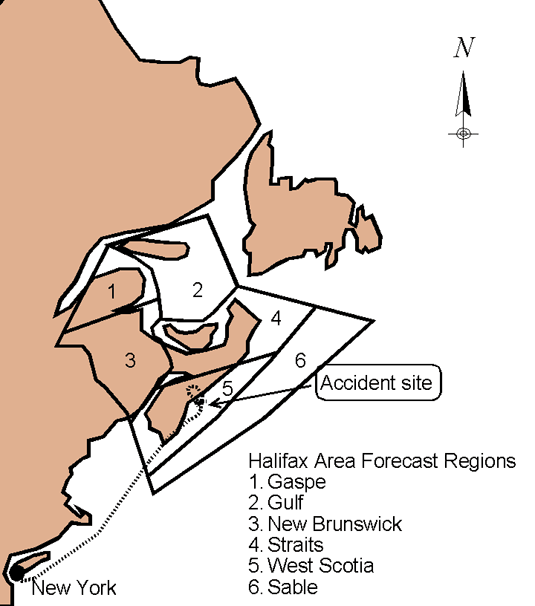
The FACN35 covered Halifax and the surrounding maritime provinces. This district comprises the following regions: Gaspé, Gulf, New Brunswick, Straits, West Scotia, and Sable. The accident site is within the West Scotia region (area 5) of the FACN35. The prognosis for the FACN35, issued at 2330 on 2 September 1998 and valid from 0000 to 1200 on 3 September 1998 indicated that, at 0000, there was a weak upper trough running north-northeast to south-southwest in the western part of the district. This trough was forecasted to move eastward at 20 knots to lie in the vicinity of Fredericton, New Brunswick, at 1200. At 0000, Hurricane Danielle was forecast to pass well south of the Sable region overnight. Patchy, low-level moisture was forecast over all the regions, becoming moist at all levels west and near the trough and over the Sable region. Light, easterly winds were forecast over the regions, increasing to moderate and strong easterly winds over the Sable region after the mid-period of the forecast. The forecast weather for the West Scotia region called for scattered, occasionally broken clouds at 2 000 to 3 000 feet with tops at 8 000 feet, broken, occasionally overcast clouds at 10 000 feet with tops at 16 000 feet, and high, broken clouds above 25 000 feet. Visibility was forecast to be greater than 6 sm. The forecast for the district included severe, clear icing in the cumulonimbus clouds and moderate, mixed icing in the altocumulus and towering cumulus. However, light to moderate rime icing was forecast elsewhere in clouds above freezing level. The freezing level was forecast at 9 000 feet asl in the northern part of the district, rising to 13 000 feet asl in the southern part. The forecast turbulence was moderate to severe in convective clouds, and otherwise light to nil.
Additional terminal aerodrome forecasts
| Airport | Issued | TAF Information |
|---|---|---|
| JFK | 2327 and valid from 0000 to 2400 on 3 September 1998 | Surface wind 170°T at 12 kt; visibility greater than 6 sm; scattered clouds at 2 500 ft. agl; broken clouds at 13 000 feet; visibility 2 sm in thunderstorms (temporarily from 0000 to 0200); overcast at 2 500 ft. agl in cumulonimbus |
| CYQI | 2244 and valid from 2300 on 2 September 1998 to 1100 on 3 September 1998 | Surface wind 320°T at 3 kt; visibility greater than 6 sm; few clouds at 2 000 ft. agl, broken clouds at 7 000 ft. agl, and broken clouds at 25 000 ft. agl |
Additional METARs
| Airport | Issued | METAR information |
|---|---|---|
| KBOS | 0056 | Surface winds 120°T at 8 kt; visibility 10 sm; sky clear; temperature 17°C; dewpoint 16°C; altimeter setting 29.78 in. Hg |
| KBGR | 0053 | Surface winds 220°T at 4 kt; visibility 10 sm; sky clear; temperature 17°C; dewpoint 12°C; altimeter setting 29.77 in. Hg |
| CYHZFootnote 1 | 0200 | Surface winds 070°T at 5 kt; visibility 15 sm; broken clouds at 12 000 ft. agl, overcast at 24 000 ft. agl; temperature 17°C; dewpoint 14°C; altimeter setting 29.79 in. Hg; cloud cover: altocumulus 7/8, cirrostratus 1/8 |
| CYAW | 0200 | Surface winds 050°T at 6 kt; visibility 15 sm; few clouds at 2 000 ft. agl, scattered clouds at 7 000 ft. agl, overcast at 25 000 ft. agl; temperature 17°C; dewpoint 15°C; altimeter setting 29.76 in. Hg; cloud cover: stratus cumulus 1/4, altocumulus 1/4, cirrus 3/8 |
| CYQI | 0100 | Surface winds 030°T at 3 kt; visibility 15 sm; broken clouds at 5 000 ft. agl and overcast at 8 000 ft. agl; temperature 18°C; dewpoint 12°C; altimeter setting 29.76 in. Hg; cloud cover: stratocumulus 7/8, altostratus 1/8 |
An automatic weather station at WWE, located approximately 39 sm southwest of the accident site on the Atlantic coast, did not record the cloud layers but recorded the visibility as greater than 9 sm at 0100.
Winds and temperatures aloft in the Halifax area
The forecasted winds for the Halifax area issued at 1530 on 2 September 1998 for use from 2100 on 2 September 1998 to 0600 on 3 September 1998 were as follows:
| Altitude (ft.) | Direction (°T) | Speed (kt) | Temperature (°C) |
|---|---|---|---|
| 18 000 | 200 | 13 | −9 |
| 12 000 | 200 | 10 | 1 |
| 9 000 | 180 | 8 | 6 |
| 6 000 | 140 | 11 | 10 |
| 3 000 | 100 | 16 | Not available |
| Sea level | 90 | 10 | Not available |
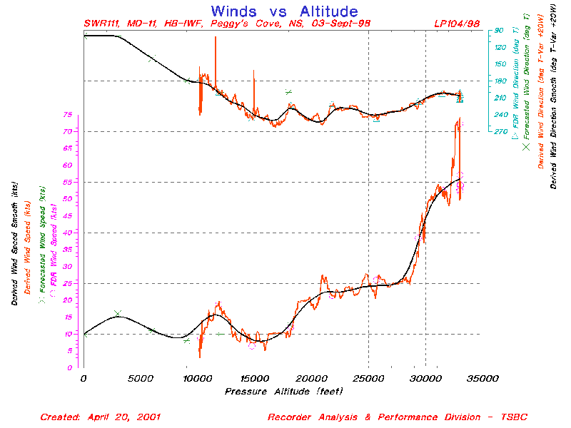
The SR 111 FDR data was analyzed to determine the actual winds and temperatures during the descent in the Halifax area. In summary, from 33 000 feet down to 18 000 feet the wind direction veered from approximately 200 to 270°T; from 18 000 to 10 000 feet, the wind direction backed to 180°T. From 33 000 to 10 000 feet, the wind velocity decreased from 66 knots to 4 knots and the air temperature increased from –40 to 4°C; the temperature at 25 000 feet was –25°C and at 12 000 feet was 0°C. (The magnetic variation for Halifax is 20 degrees west.)
Significant meteorological information
The SIGMET 1E was issued by the US National Weather Service on 3 September 1998 at 0055 and was valid until 0255 on 3 September 1998. The SIGMET indicated that there was a line of severeFootnote 2 thunderstorms extending from 30 nm northwest of Concorde, New Hampshire, through Bridgeport, Connecticut, to 40 nm south of Newark, New Jersey, to 50 nm northeast Baltimore, Maryland. The line was 20 miles wide, moving from the northwest at 30 knots, with cloud tops up to 41 000 feet. The forecast warned of hail of up to one inch in diameter and possible surface wind gusts to 50 knots, mainly south of Bridgeport.
There were no SIGMETs in effect for the FACN35 at or around the time of the occurrence.
Pilot weather reports
There were two PIREPs issued for the route of flight on the night of the accident. At 2335, the crew of a Boeing 737 passing through 14 500 feet over Boston reported that there was a broken cloud layer beginning at 3 500 feet extending up to 14 500 feet and no turbulence. At 0335, the crew of a Boeing 747 in the Yarmouth area at FL330 reported smooth flight conditions with light to moderate turbulence in the vicinity of Boston.
Thunderstorms
ATS-recorded communications tapes were reviewed for information about the thunderstorms in the JFK area. At 0014, JFK tower warned aircraft of a Level 5 thunderstorm 15 nm southwest of JFK. The flight crew of another aircraft on the departure control frequency reported thunderstorm activity over the Merit intersection (50 nm northeast of JFK). The same crew reported that the thunderstorms were in a line from the Merit intersection heading southwest.
The JFK METAR issued at 2351 on 2 September 1998 indicated that there were cumulonimbus clouds in the distance (more than 10 nm from the airport) towards the northwest, with occasional lightning. The JFK METAR issued at 0010 on 3 September 1998 indicated thunderstorms in the vicinity (less than 10 nm) in the west to northwest quadrant moving eastward with occasional lightning. The JFK METAR issued at 0051 on 3 September 1998 indicated thunderstorms in the vicinity to the south and thunderstorms in the distance to the southwest moving eastward with frequent lightning.
The NWS radar systems are able to objectively determine radar weather echo intensity levels using VIP equipment. Thunderstorm intensity levels are classified on a scale of one to six, as follows:
| VIP Level | Reflectivity (dBZFootnote 3) |
Precipitation |
|---|---|---|
| Level 1 | 18–30 | Light precipitation |
| Level 2 | 30–38 | Light to moderate rain |
| Level 3 | 38–44 | Moderate to heavy rain |
| Level 4 | 44–50 | Heavy rain |
| Level 5 | 50–57 | Very heavy rain; hail possible |
| Level 6 | >57 | Very heavy rain and hail; large hail possible |
Lightning
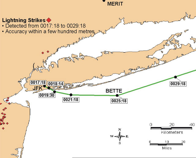
The closest cloud-to-ground lightning activity was located approximately 23 nm from the SR 111 track. It is common for horizontal components of cloud-to-ground lightning to channel within a cloud or through several clouds for up to 5 to 10 miles. Once the aircraft was past the BETTE intersection at 0025, all cloud-to-ground lightning and thunderstorm activity was well behind it for the remainder of the flight.
Research conducted by NASA and the National Severe Storm LaboratoryFootnote 4 on the electromagnetic interaction between lightning and aircraft identified atmospheric conditions conducive to cloud-to-aircraft lightning strikes. In-flight experiments have shown that there are two types of aircraft lightning strikes. The most frequent type (accounting for 90% of events) is lightning that is triggered by the intrusion of an aircraft into a region with an intense electrostatic field. The other type occurs when an aircraft intercepts a branch of natural cloud-to-cloud or cloud-to-ground lightning.Footnote 5 Nearly all strikes at any altitude or temperature occur while the aircraft is within a cloud and experiencing some form of precipitation.
There have been reports of several catastrophic accidents and many less serious incidents attributable to lightning strikes over the years. In all instances studied, the accident occurred immediately after the lightning strike as a result of fuel explosion or a combination of severe turbulence and a lightning strike. On rare occasions, there have been reports of damage to aircraft attributable to lightning discovered by maintenance personnel, although the flight crews of these aircraft were unaware that any lightning strikes had occurred. Lightning strikes are usually accompanied by an in-flight disruption (light, noise, static, etc.) The FDR was reviewed for any anomalies that might have indicated any unusual electrical disturbance within the aircraft. No such anomalies were identified.
In order for cloud-to-aircraft lightning to occur, SR 111 would have had to have been in a region with an intense electrostatic field. When the aircraft departed JFK, there was a layer of broken clouds at 2 200 to 2 500 feet and another broken layer at 4 000 feet. The aircraft would have passed through the first layer in less than one minute; a minute and a half later, the aircraft had deviated around the weather (likely either cumulonimbus or an isolated thunderstorm). It is therefore unlikely that the aircraft would have built up an electrostatic charge intense enough to promote lightning. Had the aircraft been struck by lightning and had the flight crew considered the outcome of such encounter serious, they would likely have reported it to ATS; routine lightning associated with thunderstorm activity would not normally be reported by flight crews.
| Lightning strike data | Aircraft position | Distance between aircraft & Lightning |
|||||
|---|---|---|---|---|---|---|---|
| Time | Lat. N | Long. W | Lat. N | Long. W | sm | km | nm |
| 0013:33 | 40.9562 | 73.8329 | 40.58899 | 73.721 | 26 | 42 | 23 |
| 0022:16 | 40.3836 | 74.2762 | 40.56564 | 73.64 | 36 | 58 | 31 |
| 0022:16 | 40.4483 | 74.2132 | 40.56564 | 73.64 | 31 | 50 | 27 |
| 0022:16 | 40.3462 | 74.2937 | 40.56564 | 73.64 | 38 | 61 | 33 |
| 0024:51 | 40.4466 | 74.3134 | 40.55191 | 73.0591 | 66 | 107 | 58 |
| 0024:55 | 40.1977 | 74.2814 | 40.55191 | 73.0481 | 70 | 112 | 60 |
| 0025:23 | 40.5013 | 74.2265 | 40.55878 | 72.9712 | 66 | 107 | 58 |
| 0025:23 | 40.4787 | 74.2302 | 40.55878 | 72.9712 | 66 | 107 | 58 |
| 0025:23 | 40.4783 | 74.2304 | 40.55878 | 72.9712 | 66 | 107 | 58 |
| 0025:23 | 40.4762 | 74.2423 | 40.55878 | 72.9712 | 66 | 107 | 58 |
| 0025:24 | 40.3987 | 74.2561 | 40.55878 | 72.9712 | 69 | 110 | 60 |
| 0025:30 | 40.9706 | 73.7732 | 40.56427 | 72.9506 | 51 | 83 | 45 |
| 0026:10 | 40.2446 | 74.308 | 40.59311 | 72.8435 | 81 | 130 | 70 |
| 0026:10 | 40.2415 | 74.3058 | 40.59311 | 72.8435 | 81 | 130 | 70 |
| 0026:10 | 40.2398 | 74.3126 | 40.59311 | 72.8435 | 81 | 130 | 70 |
| 0026:11 | 40.2434 | 74.311 | 40.59311 | 72.8435 | 81 | 130 | 70 |
| 0026:11 | 40.2478 | 74.314 | 40.59311 | 72.8435 | 81 | 130 | 70 |
| 0026:48 | 40.2761 | 74.3145 | 40.61783 | 72.7432 | 86 | 139 | 75 |
| 0026:48 | 40.2463 | 74.2384 | 40.61783 | 72.7432 | 83 | 133 | 72 |
| 0027:02 | 40.3096 | 74.2678 | 40.63019 | 72.6965 | 86 | 139 | 75 |
| 0027:02 | 40.3149 | 74.2758 | 40.63019 | 72.6965 | 86 | 138 | 75 |
| 0027:02 | 40.3115 | 74.2658 | 40.63019 | 72.6965 | 86 | 138 | 74 |
| 0027:15 | 40.2833 | 74.3098 | 40.63843 | 72.6622 | 90 | 145 | 78 |
| 0027:15 | 40.2829 | 74.3142 | 40.63843 | 72.6622 | 90 | 146 | 79 |
| 0027:45 | 40.3364 | 74.2664 | 40.66177 | 72.5688 | 92 | 148 | 80 |
| 0028:01 | 40.2954 | 74.2876 | 40.67413 | 72.5235 | 97 | 155 | 84 |
| 0028:36 | 40.2721 | 74.2941 | 40.69748 | 72.4301 | 102 | 165 | 89 |
| 0028:36 | 40.2482 | 74.2751 | 40.69748 | 72.4301 | 102 | 165 | 89 |
| 0028:36 | 40.2487 | 74.2813 | 40.69748 | 72.4301 | 102 | 165 | 89 |
| 0028:46 | 40.3085 | 74.2802 | 40.70572 | 72.3958 | 103 | 166 | 89 |
Weather information received from British Airways Flight 214 (Speedbird)
The following Halifax weather information was volunteered by the Speedbird flight crew to the flight crew of SR 111 at 0116: Winds 100 degrees at 9 knots; visibility 15 miles, scattered clouds at 12 000 feet, broken clouds at 25 000 feet; temperature 17°C; dewpoint 12°C; altimeter setting 29.80 in. Hg.
The weather reported by Speedbird was dated 3 September at 0000. The printed code beside the weather report was 030000. The Speedbird flight crew inadvertently stated that the 0000 weather was the 0300 weather.
Weather requested by flight crew via ACARS
After the flight crew noticed the fumes in the cockpit, they discussed checking the weather for various destinations, including New York, Boston, and Bangor. At 0014, the flight crew requested the weather using the ACARS for the following airports: LLSG, JFK, KBOS, and CVQM (unknown). It is possible that the flight crew intended to input CYQM, which is Moncton, New Brunswick, an airport 90 nm northwest of Halifax.
Pre-flight briefing
Weather information at the FOC is obtained through FOCUS. This system is based in Zurich and provides information to all the Swissair stations. Weather maps are obtained from Washington, DC, from the NWS.
At approximately 1900 on the day of the flight, the FOC sent a pre-flight package to the hotel where the flight crew was staying for the flight crew to review. Included in this package was the routing information, weather information, and the planned load. Although a briefing is not necessary if there are no flight irregularities, the FOC at JFK briefs pilots on every flight in order to establish a good relationship between dispatch and the pilots. The official flight plan, which includes Notices to Airmen, routing information, weather information, and the actual weight is provided to the pilots when they arrive and they are typically briefed by the FOO responsible for creating the flight plan. If there is a change in the flight plan, it is usually initiated by the flight crew. Such a flight track change may result if the crew decides to carry a minimum fuel load. On occasion, the aircraft might have a two-hour taxi time. Once the flight crew has been briefed and has approved and signed the flight plan, they proceed to the aircraft. The gate staff controls security to the jet way where there is a cipher lock to the jetway.
During the pre-flight briefing, the flight crew was told about a weather system in the area caused by Hurricane Danielle. As a result of this weather, their track would take them further north. The crew accepted the change and signed the flight plan. The taxi and take-off from JFK were unremarkable with the exception of the crew requesting a diversion from ATC around some weather upon departure.
Weather observed on the ground in the vicinity of Peggy's Cove
According to observers inland, on the coast, and on the ocean near the accident site, the sky was overcast and it was hazy or foggy over the water with the base of clouds being much higher inland. These observations were generally consistent with the forecast and aftercast weather produced by EC. Observers on the shore near the accident site saw the aircraft as it flew by and estimated it to have been about 700 to 1 000 feet agl.
Weather observed in the air in the Halifax area
The crew of an aircraft that had departed Halifax shortly after the accident offered assistance to ATS. The controller gave the crew radar vectors to steer the aircraft along the radar track of SR 111. As the vectored aircraft was cleared to descend to 3 000 feet asl, it encountered a broken cloud layer with tops at 5 000 to 7 000 feet. At 3 000 feet, the crew initially were unable to see the surface of the earth, but an opening in the clouds allowed the crew to descend visually down to 1 500 feet. At 1 500 feet, the flight crew was able to see the moon through the broken layer and was able to identify the lights of emergency vehicles on the ground. The flight crew was unable to identify any aircraft wreckage on the ground or in the water.
The flight crew of another aircraft was approaching Halifax from the northwest at the time of the accident. The captain stated that the visibility was good below the base of a cloud layer at approximately 12 000 feet and that it was a black night with no visible horizon.
Other information
There is an EC Upper Air Station at Yarmouth, Nova Scotia, 133 miles west of Halifax. This station recorded data 1 hour and 15 minutes before the aircraft's descent from FL330. The top of cloud was at 16 000 to 17 000 feet and the freezing level was at 11 000 to 12 000 feet.
Good visibility and ambient light conditions should have prevailed above the top of cloud as the moon's disk was 85% full and 26 degrees above the horizon.
Turbulence
ATS-recorded communications tapes were reviewed for information about turbulence. Near the eastern tip of Long Island, New York, there was a report of light, and occasionally moderate, turbulence at FL280 and light turbulence at FL310. South of Cape Cod, Massachusetts, there was a report of very light continuous turbulence at FL290. All aircraft reported that FL330 was smooth (no turbulence), while FL350 had moderate turbulence. At no time did the flight crew of SR 111 comment on turbulence to ATS while in US airspace. When SR 111 approached Canadian airspace and contacted Moncton Centre, the controller informed the flight crew that there were reports of occasional light turbulence at all levels. Moncton Centre also informed other aircraft of the reported light turbulence at all levels in the area. Shortly after the unusual odour in the cockpit was detected, the seat belt lights were activated in reaction to the light turbulence being experienced.
For the most part, the flight would have been in smooth air with occasional light turbulence. It is possible, however, that during the departure and climb-out from JFK, SR 111 may have encountered some turbulence due to the proximity of thunderstorms. Subsequently, the flight would have flown in smooth air with occasional turbulence until it reached Canadian airspace, at which time light turbulence was reported.
Icing
A review of the FDR data revealed that the wing, tail, and engine anti-ice valves were closed during the flight.
Data from the Upper Air Station at Yarmouth revealed that the freezing level was approximately 12 000 feet. The area forecast predicted that the freezing level to the south of the district was 13 000 feet, lowering to 9 000 feet in the north, with light rime icing in cloud. The FDR also revealed that the freezing level was approximately 12 000 feet. The TAFs and METARs for Halifax and Shearwater indicated that there was a cirrus layer at approximately 25 000 feet. When the aircraft was descending through this cloud layer, it is likely that the aircraft did not encounter any airframe ice owing to the cold temperatures and sparse amount of cloud. The next layer of clouds had a base of approximately 12 000 feet. As SR 111 entered this cloud, it is possible that it encountered some icing to approximately 12 000 feet; however, the amount and duration would have had a negligible effect and any accumulation on the aircraft would have dissipated by 12 000 feet. The FDR revealed that the airframe and engine anti-ice systems were not utilized, indicating that the flight crew did not turn on the anti-ice systems. There was no freezing precipitation either forecasted or reported.
Instrument meteorological conditions
The flight that approached the Halifax airport from the northwest would have had cloud cover below them in the distance towards the sea. This would obscure the distant horizon and increase the darkness of the night. Likewise, when SR 111 was tracking toward the ocean, it would have been dark over the sea as a result of the cloud cover, mist, and lack of surface lights.