Controlled flight into obstacle and terrain
Keewatin Air Limited
Swearingen Merlin II C-FFYC
Thompson, Manitoba
The Transportation Safety Board of Canada (TSB) investigated this occurrence for the purpose of advancing transportation safety. It is not the function of the Board to assign fault or determine civil or criminal liability. This report is not created for use in the context of legal, disciplinary or other proceedings. See Ownership and use of content. Masculine pronouns and position titles may be used to signify all genders to comply with the Canadian Transportation Accident Investigation and Safety Board Act (S.C. 1989, c. 3).
Summary
The Swearingen Merlin II was returning to Thompson after having completed a MEDEVAC flight between Coral Harbour, Northwest Territories, and Churchill, Manitoba. After being cleared for a localizer back course approach to the Thompson Airport, the aircraft descended below the minimum beacon-crossing altitude, struck the Hotel non-directional beacon tower in a wings-level attitude, and crashed. Both crew members were fatally injured, and the flight nurse was seriously injured.
The Board determined that the flight crew lost altitude awareness during the localizer back course approach and allowed the aircraft to descend below a mandatory level-off altitude. Contributing factors to this occurrence were the crew's deviation from a published approach procedure, ineffective in-flight monitoring of the approach, rapidly developing localized fog conditions, and, probably, pilot fatigue.
1.0 Factual Information
1.1 History of the Flight
The twin-engine turboprop aircraft had just completed a medical evacuation (MEDEVAC)Footnote 1 flight from Coral Harbour, Northwest Territories (NWT), to Churchill, Manitoba. At 2257 central daylight saving time (CDT)Footnote 2, the aircraft departed Churchill for a night, instrument flight rules (IFR) flight to return to the aircraft's base of operations at Thompson, Manitoba. The en route portion of the return leg was conducted at an altitude of 18,000 feet above sea level (asl)Footnote 3.
Approximately one hour after take-off, the aircraft commenced an approach to the Thompson Airport. The crew remained in radio contact with air traffic control (ATC) personnel until approximately 2359 CDT.
Just after midnight (0001 CDT), the Hotel non-directional beacon (NDB), which is located 3.4 miles northeast of the Thompson Airport, stopped transmitting. Ninety minutes later, the search and rescue satellite system (SARSAT) picked up an emergency locator transmitter (ELT) signal to the northeast of the airport. Thompson Airport staff, who had been dispatched to the site of the failed navigation beacon, found the wreckage of the aircraft in and around the NDB transmitter compound. Emergency responses were initiated by various airport and local authorities.
The accident occurred at 0001 CDT, 01 June 1994, at latitude 55·50′N and longitude 097·46′W, during hours of darkness.
1.2 Injuries to Persons
| Crew | Passengers | Others | Total | |
|---|---|---|---|---|
| Fatal | 2 | - | - | 2 |
| Serious | - | 1 | - | 1 |
| Minor/None | - | - | - | - |
| Total | 2 | 1 | - | 3 |
1.3 Damage to Aircraft
The aircraft's right wing and engine collided with the Hotel NDB antenna structure and two of its supporting guy wires. Following that initial collision, the aircraft continued forward and struck a second antenna tower, which is associated with the Position Adjustable Range Reference Orientation Transponder (PARROT) system. That system is designed to receive secondary surveillance interrogation signals from aircraft transponders and is an integral component of the Transport Canada Radar Modernization Program (RAMP). The PARROT antenna had been recently installed at the NDB site but was not operating at the time of the accident. After colliding with the two towers, the aircraft struck the ground and was destroyed by the impact forces.
1.4 Other Damage
The Hotel NDB tower and the PARROT antenna systems were both damaged by the collision. There was also minor ecological damage to a stand of deciduous trees in the vicinity of the crash site.
1.5 Personnel Information
| Captain | First Officer | |
|---|---|---|
| Age | 50 | 29 |
| Pilot Licence | ATPL | ATPL |
| Medical Expiry Date | 01 Dec 95 | 01 Jun 95 |
| Total Flying Hours | 20,000+ | 3,700 |
| Hours on Type | 3,160 | 375 |
| Hours Last 90 Days | 140 | 178 |
| Hours on Type Last 90 Days | 140 | 140 |
| Hours on Duty Prior to Occurrence | 9 | 9 |
| Hours Off Duty Prior to Work Period | 72+ | 15 |
1.5.1 Captain
The captain was a qualified airline transport pilot and was current on the Merlin II aircraft. He had more than 20,000 hours of flying experience, most of which had been accumulated in remote regions of Northern Ontario, Manitoba, and the Northwest Territories. He had been employed with the company for 2 1/2 years and had been recently promoted to the position of assistant chief pilot. Two months prior to the accident, the captain had been re-assigned from the Rankin Inlet, NWT, base to the Thompson Base. The captain had more than 3,000 hours of MEDEVAC experience on the Merlin II aircraft.
The captain was occupying the right crew seat at the time of the accident and was fulfilling duties of a pilot not flying (PNF) when the collision occurred.
1.5.2 First Officer
The first officer was flying from the left crew seat at the time of the accident. He held a valid Airline Transport Pilot Licence (ATPL) and a pilot proficiency check (PPC) on the Merlin II, and was certified to serve as a first officer on that aircraft type. In addition, he was licensed and qualified as a captain of the Piper Navajo, Piper Seneca, Britten Norman Islander, and Beechcraft Baron aircraft types. The first officer had accumulated approximately 3,700 hours of total flying experience, 375 hours of which was on the Merlin aircraft. The majority of that time was flown in the right seat of the aircraft as a first officer. Records indicate that he had only three hours of experience flying from the left seat of the Merlin aircraft.
The first officer was tentatively scheduled to be upgraded to relief captain on the Merlin II aircraft in June 1994.
1.5.3 Medical Nurse
A Manitoba Health and Welfare licensed nurse employed by the company was on board the aircraft at the time of the accident. The nurse's duties required him to perform essential medical functions during the transport of medical patients. During this return portion of the MEDEVAC flight, there were no patients on board and the nurse was resting in the aircraft cabin when the collision occurred.
1.6 Aircraft Information
| Manufacturer | Swearingen Aviation Corp |
|---|---|
| Type | SA26T Merlin II |
| Year of Manufacture | 1969 |
| Serial Number | T26-36 |
| Certificate of Airworthiness (Flight Permit) | Valid |
| Total Airframe Time | 12,633.7 hr |
| Engine Type (number of) | Pratt & Whitney PT6A-34 (2) |
| Propeller/Rotor Type (number of) | Hartzell HC-B3TN-3D (2) |
| Maximum Allowable Take-off Weight | 9,868 lb |
| Recommended Fuel Type(s) | Jet A, Jet B, P50, DFA, Avgas |
| Fuel Type Used | Jet B |
1.6.1 General
The aircraft was being maintained on a 200-hour progressive maintenance program with an A, B, C, and D check due every 50 hours. The most recent inspection was a "C" check which was completed on 18 May 1994 at a total airframe time of 12,587 hours. During that check, the co- pilot's artificial horizon and the right hand voltage regulator were replaced and the generators were balanced.
Entries in the aircraft's Technical and Journey Log books indicate that there were no recorded aircraft unserviceabilities, and the aircraft was accepted as being airworthy at the commencement of the flight from Churchill back to Thompson.
The aircraft was configured for MEDEVAC operations. The interior had been modified to incorporate essential medical equipment along with seating and stretcher locations for a flight nurse, several patients, and patient escorts.
The aircraft's weight and balance were within limits.
1.6.2 Altimeter Displays
The altimeter installed on the left side of the instrument panel employs a combination counter- drum/pointer display of the general type shown in Figure 1. Essential altitude information is presented to the pilot as a digital display, through the combined readings of the counters and the drum. A needle-shaped pointer, which is geared to the inner drum, rotates around a central pivot point on the circular dial and indicates an altitude change of 1,000 feet for each revolution. This pointer acts as a vernier for the hundreds drum, and also provides altitude trend information.
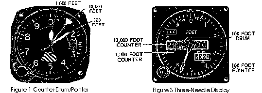
The altimeter installed on the right side of the instrument panel uses an older style three-needle display similar in design to the altimeter mounted in the company's Piper Navajo aircraft, as shown in Figure 2. Essential altitude information is presented to the pilot by use of three separate needle-shaped pointers which sweep a graduated circular scale and give the following information:
- a long thin pointer with an inverted triangle at the outer end displays tens of thousands of feet;
- a short, broad pointer displays thousands of feet; and,
- a long, medium pointer displays hundreds and lesser units of feet.
1.6.3 Altitude Alerting System
The aircraft is equipped with an altitude alerting system (IDC 540) which provides both aural and visual warnings to the pilot when the aircraft enters an altitude that is 300 feet above or below any pre-selected altitude. The visual warning associated with this system is a large, brightly lit amber light that is mounted on the alerting system's display in the centre of the instrument panel glareshield. At night, the brightness of this light can be distracting, and, once the alerting system is no longer needed or desired, crews normally deactivate the light by rotating the altitude selector knob clockwise to a higher altitude setting. The normal procedure, as outlined in the company Flight Operations Manual and aircraft checklist, is to use this altitude alerting system during the climb, en route, and en route-descent portions of a flight. During the final approach phase of flight, crews rely on their own monitoring of the altimeter display information as part of their normal instrument scanning cross check, as well as on the information and warning provided by the radar altimeter system.
The altitude alerting system was found to be set to 5,400 feet after the accident.
1.6.4 Radar Altimeter System
The aircraft was equipped with a King (KRA 405) radar altimeter system. The indicator display (KNI 416), control head, and visual warning associated with the radar altimeter are located on the lower portion of the instrument panel, in the vicinity of the left-seat pilot's right knee.
The radar altimeter, which measures the absolute height of the aircraft above the terrain, has a minimum altitude marker which can be set to any desired altitude value below 2,000 feet above ground level (agl). The system will generate both visual and audio warnings when the aircraft descends to, or is below, the pre-set value. These warnings can be cancelled out by pilot selection.
The radar altimeter is normally used for the final approach portion of the flight, and is not usable at altitudes above 2,000 feet agl.
The aural warning system associated with the radar altimeter is an unamplified sonalert audio horn mounted on the side panel near the left-seat pilot's right knee. The horn emits a high frequency, pulsating sound at an 80 decibel (db) volume level. The sound is unique and should normally be distinct and identifiable from other aircraft warning systems. The aural warning horn (sonalert) was properly wired, and was tested to be serviceable after the accident. The audio output signal from the radar altimeter could not be selected by the flight crew for use over the aircraft's speaker or headphone system.
Testing and evaluation of the sonalert horn indicated that the 80 db warning could be attenuated to as low as a range of 31-37 db by the time it reached the pilots' ears if headsets were being used. This level of sound would be barely audible above the ambient noise of the cockpit.
1.6.5 Intercom System
The aircraft was equipped with a King (KAA 445) audio communication system which integrates the audio outputs from various radio receivers to supply audio to the flight crew's headsets or, alternatively, to the cockpit speakers.
The aircraft's audio system does not incorporate a hot microphone feature, which would permit continuous inter-cockpit communication. To communicate using the intercom system, one of the crew members was required to select a panel-mounted rotary selector switch to the PA position and then depress a transmit button which is located on either control column. Standard practice within the company was to select the PA position, and have the pilot-flying depress and hold down the transmit button during the final approach phase of the flight. Some pilots were known to position an elastic band around the control column in order to hold the transmit button in its activated position. The effect of these procedures was to give the crew a hot microphone while on final approach to facilitate crew communication and coordination during this busy phase of flight.
1.7 Meteorological Information
The Thompson terminal forecast (FT YTH 312311), valid for the period near midnight on 31 May 1994, predicted an 800-foot agl broken ceiling and six miles visibility, with conditions lowering to a thin obscured, overcast ceiling at 800 feet agl, and two miles visibility in fog for occasional periods.
The weather observation (YTH SA 0500) taken at the Thompson Airport at midnight reported a 1,200-foot broken ceiling with a higher broken layer above at 8,000 feet agl. The visibility was reported to be 15 miles, the temperature 11 ° C, the dew point 10 ° C and the altimeter setting 30.17. No fog was reported in that hourly observation. A special weather report (YTH SP 0529) was issued approximately 30 minutes after midnight to indicate that the visibility had decreased to four miles in fog at the Thompson Airport.
The crew of an aircraft that departed Thompson approximately 45 minutes after the accident reported to the Thompson flight service station (FSS) that they lost visual contact with the ground at approximately 200 feet agl. The visibility during their take-off roll was reported to be 1/2 mile in fog and the top of the fog layer was estimated to be approximately 500 feet agl at that time.
1.8 Aids to Navigation
1.8.1 Hotel NDB
The Hotel NDB is a low frequency transmitter, located 3.4 nautical miles (nm) northeast of the airport on the extended approach path to runway 23. The transmitter is used as a navigational aid for instrument approaches to that runway and serves as the final approach fix for the localizer back course approach to runway 23. The NDB tower stood 87 feet above the ground elevation of 730 feet asl. Although the top of the tower was unlit, there was a single yard-light mounted on an equipment building at the base of the tower. This light was visible to flight crews that overflew the crash site following the accident.
1.8.2 Instrument Landing System (ILS) Localizer
The localizer back course portion of the Thompson ILS serves runway 23.
The correct ILS frequency and the appropriate course for the published approach were set into the aircraft's navigational information display instrument used by the left-seat pilot. The left-side altimeter was also accurately set. The right-side navigational equipment was tuned to the appropriate ILS frequency, but the course setting, the heading selector bug, and the right-side altimeter were not accurately set to monitor the approach.
1.8.3 On-board GPS Equipment
The aircraft was equipped with a global positioning system (GPS) receiver. This system provides navigational information by using time and position data from a network of satellite transmitters. GPS is considered a supplemental navigation system and is not yet certified or approved for use as a sole means navigational aid in Canada, but it may be used as a cross reference for other navigational systems.
Data recovered from the GPS receiver after the accident indicated the following:
- the selected GPS waypoint was the Thompson VOR,
- at some point during the flight, the crew had been navigating direct to that location; and,
- the last indicated time and date was 00:01:33.8 CDT, 01 June 1994.
1.9 Communications
The flight from Churchill was conducted entirely within controlled airspace, but was outside the area of ATC radar coverage; therefore, no ground radar information relating to altitude or position of the aircraft was available.
The captain was handling the radio communications with ATC throughout the trip. At 2349 CDT, the captain reported that the aircraft was 42 miles northeast of Thompson and requested a descent clearance. The aircraft was initially cleared down to 7,000 feet asl. Several minutes later, the crew was given a clearance for an approach to the Thompson Airport, with a restriction to remain on the 030· radial of the Thompson VOR until below 3,000 feet asl. Approximately eight minutes after initiating their descent, the crew reported that the aircraft was descending through 3,000 feet, and that they were 12.3 miles back from the Thompson VOR. The Winnipeg Area Control Centre informed the flight crew to contact Thompson FSS for in-flight monitoring.
The aircraft's initial radio contact with Thompson FSS was at approximately 2358 CDT. The crew indicated that they were planning to complete a localizer back course approach to runway 23, they already had their approach clearance, and they would call once established on the final approach. The FSS operator provided the latest local weather observation and altimeter setting; that setting was read back correctly as 30.17. The Thompson FSS operator requested that the crew provide a pilot report (PIREP) on the cloud bases during their approach to the airport.
1.10 Aerodrome Information
Thompson is a certified airport that is operated by the Local District Government of Mystery Lake. The airport's main runway is oriented on a 050·/230· magnetic heading, at an elevation of 729 feet above mean sea level (amsl). Runway 23 is served by published NDB and localizer back course approaches. Both of these published instrument approaches use the Hotel NDB as a navigational fix.
The localizer back course approach to runway 23 has been designed to incorporate an intermediate descent on the 11-mile arc to intercept the localizer inbound. Once established on the localizer, the descent can be made to 1,500 feet asl until crossing the Hotel NDB. From that point, the aircraft may continue the descent to the minimum descent altitude (MDA) published for the approach, which, for the localizer approach to runway 23, is 1,080 feet asl.
The airport is equipped with an ATC tower which operates at limited times. The ATC tower was not operating at the time of the accident and the Thompson FSS was providing standard services to local aircraft traffic.
A weather observer, located at the Thompson Airport, provides weather observations for the Atmospheric Environmental Service (AES) weather information system.
1.11 Flight Recorders
The aircraft was not equipped with either a cockpit voice recorder or flight data recorder and neither was required by regulation.
1.12 Wreckage and Impact Information
1.12.1 General
The aircraft struck the Hotel NDB tower in a wings-level attitude at 62 feet above ground. Approximately five feet of the right wing was severed from the outboard edge and was recovered at the base of the tower. The right propeller severed one of the tower support cables and the tower was knocked off its base. The aircraft continued forward and struck the PARROT beacon antenna, knocking the top off the antenna and ripping up several buried cables that were attached to the tower.
After colliding with the two towers, the aircraft began a roll to the left and descended steeply through the trees on a track of 230 ° magnetic. The aircraft hit the ground in a steep nose-down, left-wing-low attitude approximately 450 feet from the initial impact point with the tower. Once ground contact was made, the aircraft sliced through approximately 150 feet of dense trees before coming to a stop.
During the crash, the landing gear was torn off and the main wing structure was broken into four separate segments. The fuselage separated from the wing section and hit a 12-inch diameter jack-pine. That collision split the fuselage and resulted in two separate wreckage throw patterns; the flight nurse and components from the main cabin area were thrown straight forward through a gaping hole in the front of the fuselage. The cockpit section was destroyed by the collisions with the ground and trees.
1.12.2 Wreckage Examination
The aircraft systems were examined at the accident site and no pre-impact structural failures or flight control system discontinuities were found. It wasdetermined that, at the time of the crash, the landing gear was DOWN, the flaps were UP, and the elevator was trimmed slightly nose down, consistent with a descent profile.
The aircraft checklist was found opened to the normal descent check page, indicating that the crew was performing their routine checks. A number of components and instruments were removed from the site for further examination and analysis.
Both engines and propellers were severely damaged. On initial ground contact, the left propeller and propeller shaft broke away from the left engine and rotated off into the trees to the left of the wreckage trail. The right propeller remained attached to the engine, but was canted approximately 60 ° to the engine gas generator case.
The engines and propellers were removed from the accident site and taken to the Central Region Wreckage Examination Facility for further evaluation.
No pre-impact damage was noted during either engine examination. The extensive secondary damage to both engines was typical of sudden engine stoppage of an operating engine, caused by heavy collision with terrain.
1.12.3 Propeller Examination
The propellers were three-bladed Hartzell HC-B3TN-3D series propellers. This series propeller is designed with a feathering blade angle of 87·, a low pitch blade angle of 20.2·, a zero power windmilling blade angle of 15· to 16·, and a reverse blade angle of (-)11·.
The left propeller broke away from the engine during ground contact; however, there was very little of the blade damage or twist that would normally be expected if the engine had been producing high power. There were marks on the propeller dome piston wall made by contact with the cylinder. These marks indicate that the propeller was at a blade angle of approximately 29· at ground impact.
An examination of the right propeller revealed that two propeller blades were severed--one near the tip and the other one at mid span. Cable markings were observed on the propeller spinner and on the leading edge of two propeller blades. The cable markings matched damage observed on one of the NDB tower support cables. Two sets of marks were found on the propeller dome piston wall: a light mark corresponding to a blade angle of approximately 22· and a heavy mark corresponding to a blade angle of approximately (-)14·. The light mark was likely caused by contact with the NDB tower support cable. The heavy mark was likely caused by the piston being driven hard against the full reverse stop as the propeller blades twisted off during ground contact.
Based on the post-crash propulsion systems examination, it is likely that the evidence indicating the differing power levels of the two engines after the accident was established at different points in time. That is, it is most probable that the right propeller piston mark was made on initial contact with the NDB tower, whereas the left propeller piston mark was likely established on contact with the ground.
1.12.4 Instrument Examination
Relevant engine and flight instruments were removed from the wreckage and forwarded to the TSB Engineering Branch Laboratory for further examination. To evaluate whether the individual bulbs were illuminated at the time of the impact, 42 instrument-illumination lamps were removed and examined through a stereo-optical microscope. The instrument and light bulb analyses indicated that, at the time of impact:
- the left and right fuel pressure pointers were indicating in the normal operating range of 30 to 32 psi;
- the left engine gas generator speed (Ng) was indicating in the 60 to 65 per cent range (normal descent power);
- the right engine Ng was indicating near the 50 per cent range (idle power);
- both propeller pointers were indicating between 1,900 and 2,000 rpm (fine pitch setting);
- the number one inverter was powered;
- a range of panel and instrument lights were ON;
- the aircraft's navigation equipment was tuned to the ILS frequencies for Thompson;
- the radar altimeter decision height (DH) light was ON; its four internal instrument illumination lights were ON; the instrument's DH selector was set between 380 and 400 feet agl; the warning flag was out of view when the dial face was damaged by the crash; and,
- the left-hand-side encoding altimeter was correctly set to 30.17, but the right-side altimeter was set to 30.12.
By relating the powered instruments and the illuminated lights to the aircraft's electrical wiring diagram, it was determined that the left essential and non-essential electrical buses were both being powered at impact. The status of the right essential bus at impact could not be positively determined; however, this electrical bus is known to have been powered at the time of the last radio call, approximately three minutes before the crash occurred.
1.13 Medical Information
1.13.1 Toxicology Testing
Toxicology testing was conducted at the Civil Aviation Medical Unit (CAMU) of Health Canada located in Toronto, Ontario. All toxicological test results were negative. Additionally, there was no evidence of flight crew incapacitation.
1.13.2 Crew Alertness, Fatigue, and Flight Safety
Flying an aircraft safely demands that a pilot remain constantly vigilant to monitor a variety of information sources. Also, a pilot must be able to recall a large body of knowledge from memory, and must be capable of applying this information to a constantly changing operational environment. To be effective, this skill requires that the pilot remain fit and alert.
Aircrew are monitored routinely to verify their physical fitness for flight duties. However, a pilot's level of alertness will fluctuate over time and is largely related to the number of hours awake, the time of day, the pilot's circadian rhythm, the nature of the task at hand, as well as certain aspects of the operational environment.
Research into circadian rhythms and sleep patterns indicates that, in each 24-hour period, there will be certain times that are more conducive to drowsiness, and other times which will produce the highest levels of alertness. People generally find it more difficult to sleep during periods of maximum wakefulness and, under normal circumstances, any sleep they do obtain during these periods will be poor. Additionally, research has shown that, when an individual is denied sleep for extended periods, the person's performance will be impaired. In general terms, "cumulative sleep loss and circadian disruption can lead to a decrease in alertness, impaired performance, and worsened mood"Footnote 4.
The Defence and Civil Institute of Environmental Medicine (DCIEM) has found that a 30% decrement in performance on cognitive tasks can be expected after 18 hours of wakefulness.Footnote 5 Any duty requirements that extend a crew member's time awake beyond 18 hours can be expected to result in marked impairment in the crew's information processing and problem solving abilities. This effect does not begin at 18 hours but develops over time to reach a 30% decrement in performance after approximately 18 hours of wakefulness.
In general, the performance of cognitive and vigilance tasks is particularly impaired under conditions of fatigue, and there is often an increased propensity for risk taking by the fatigued person. Taking shortcuts and failing to attend to routine parts of a task, such as resetting altimeters or radio frequencies, is much more likely when fatigued than when refreshed and alert.
1.14 Fire
There were no in-flight or post-crash fires.
1.15 Survival Aspects
1.15.1 General
Shoulder harnesses limit the movement of the upper body during a collision and help reduce the level of injury. The aircraft's crew-position seats were not equipped with shoulder harnesses, nor did existing regulations at the time of the accident require that shoulder harnesses be installed. Transport Canada recently revised the Aeronautics Act and the Air Navigation Order (Series II, No. 2) - Aircraft Seats and Safety-Belts Order, and has published these changes into the Canada Gazette Part II, Vol. 128, No. 19. The new order sets out more extensive safety-belt equipment requirements for some aircraft seats and includes the front seats, and seats on the flight deck, of some aeroplanes.
Two of the forward facing cabin seats had been modified to accommodate the loading of stretcher patients. The seat back and seat-belt attachment hardware had been replaced with quick-release pins to allow for the easy removal of the seat back. An examination of both forward facing seats revealed that the quick-release pins had jarred loose during the impact sequence, releasing both sets of these cabin seat-belts from their respective seats.
The flight nurse has no memory of the accident, but believes that he would have been sitting in the front forward-facing seat with his seat-belt attached at the time of the accident. During the impact sequence, the flight nurse was thrown from the aircraft and sustained multiple severe injuries. Neither of the two forward-facing seat-belt buckles were fastened when examined. An examination of the wreckage could not confirm where the flight nurse had been sitting, nor whether his seat-belt buckle had been attached at the time of the accident.
1.15.2 Emergency Response
When the aircraft failed to arrive at the Thompson Airport, the FSS operator initiated a communications search and ramp check, but the aircraft's location could not be verified.
The aircraft's ELT activated on impact; however, the signal was not picked up by the SARSAT until approximately 1 1/2 hours after the crash. The initial SARSAT report placed the position of the aircraft approximately 15 miles northwest of the actual crash site. The aircraft's ELT antenna was later found to be buried amongst the wreckage. The orientation of the antenna would have reduced the transmitter's signal strength because of partial shielding of the antenna by the wreckage.
A technician was dispatched to the NDB tower site to determine why the NDB had stopped transmitting. Approximately 2 hours and 40 minutes after the occurrence, the technician arrived at the site and observed aircraft wreckage in the vicinity of the NDB tower. This discovery provided the initial confirmation that a crash had occurred. The sole survivor was located approximately 20 minutes later.
1.16 Additional Information
1.16.1 MEDEVAC Operations - General
Keewatin Air Limited began providing aeromedical transport services in the NWT in 1988 and, since that time, has expanded its operation to include MEDEVAC bases in Rankin Inlet, Churchill, and Thompson. The deployment of aircraft and personnel resources between these bases is intended to minimize response times to the communities and increase the dispatch reliability of the system. Each base has hangar facilities for the aircraft and maintains a stand-by and dispatch system that allows crews to become airborne within 45 minutes of receiving a MEDEVAC request. This dispatch system requires flight crews to carry pagers and to meet stand-by duty commitments on an ongoing basis.
1.16.2 Flight Duty Times and Minimum Rest Periods
The company's Flight Operations Manual details a number of constraints on flight duty times and on minimum rest periods. Some of these constraints were introduced by the company with the objective of making their procedures more stringent than the minimum requirements outlined in Air Navigation Order Series VII, No. 3.
Flight duty time consists of the time necessary to prepare for, execute, and terminate a flight (or series of flights) and includes all of the administrative functions associated with the flight(s). Flight preparation, as outlined in the company's Flight Operations Manual, normally requires the flight crew members to report for duty at least one hour prior to departure. Crew stand-by duties include a commitment to be airborne within 45 minutes of a recall order. Stand-by crew members' off-duty activities are significantly restricted because of the strict stand-by commitments. The crew duty time begins only when the crew is recalled for a flight.
Neither the company Flight Operations Manual nor the Transport Canada Air Navigation Orders clearly define the term "rest period," although the term is referred to extensively within those publications. Transport Canada Aviation, together with the aviation industry, has been attempting to develop appropriate regulations to provide for adequate rest periods. Some crews who have been involved in MEDEVAC operations have expressed concerns about their continuing requirements to hold lengthy stand-by commitments and their capacity to commence a full and effective duty day at any time within those stand-by periods.
The captain had just returned from five days off and was conducting his first MEDEVAC flight since his return to duty. He reportedly had good sleep habits and had received adequate rest the previous night. He began his scheduled stand-by duties at 0800 CDT on the day of the accident and his crew duty-day would have begun at approximately 1430 CDT, the initial time of dispatch for this MEDEVAC flight. The captain's total flight time for the day of the accident was approximately 6.4 hours.
The first officer had been holding various stand-by and flying duties over the two-week period leading up to the accident. Over that period, he had been on stand-by for a total of 180 hours, had flown on 9 of those 14 days, and had completed 19 separate flight legs and 40.3 flight hours. Several days prior to the accident, the first officer is known to have been awake for a minimum of 36 continuous hours.
The first officer had expressed concern to a number of friends and acquaintances regarding the stress he felt resulting from his ongoing stand-by/duty commitments and was actively seeking employment with another air carrier that provided scheduled passenger services. Several days prior to the accident, the first officer received news that his bid for employment with another air carrier had failed. This news precipitated a period of discouragement, irritation, and increased anxiety. This mood shift was out of character, and was noted by his friends to extend throughout the period leading up to the accident.
On the day of the accident, the first officer began his stand-by responsibilities at 0800 CDT and was scheduled to remain on call for a 12-hour period. He awakened at approximately 0700 CDT, completed an aircrew medical in the early afternoon, and was recalled for the MEDEVAC flight at approximately 1430. His crew duty day began with that recall and, at the time of the accident, he had accumulated 9 1/2 hours of duty time and had been awake for approximately 17 hours.
1.16.3 Aircraft Descent Profile
The en route descent profile normally flown by the company pilots for the Merlin II is just under the aircraft's maximum operating speed. This profile reduces the en route time and minimizes throttle adjustments during the descent.
The Merlin crews use a simple rule-of-thumb to determine the initiation point for a descent and to confirm that the aircraft is remaining on the normal descent profile. A review of the ATC tapes indicates that the crew requested a descent from 18,000 feet asl when the aircraft was 42 nm northeast of Thompson. Application of the rule-of-thumb would have required descent initiation at 41 nm. Similarly, when the crew reported 12.3 nm from the airport, the aircraft was on a normal descent profile. By using this descent profile, the majority of the cockpit workload related to the aircraft's level-off, deceleration, before-landing checks, and reconfiguration for final approach is completed in a five-mile segment short of the destination aerodrome.
A review of the times and distances travelled during the descent showed that the aircraft's average ground speed was 214 knots and that its vertical speed was approximately 1,900 feet per minute (fpm) for the period of the descent from 18,000 feet asl to the last reported altitude of 3,000 feet asl. These computed values were used to extrapolate the point at which the aircraft would reach its initial level-off altitude. Based on that calculation, the aircraft should have been levelling off approximately 11 miles from the Thompson VOR or 9 miles to the northeast of the Hotel NDB tower.
1.16.4 Instrument Approach Procedures
Based on a review of the elapsed time between the crew's receipt of the approach clearance and the aircraft's collision with the tower, the aircraft could not have followed the published procedure, but rather must have followed a more direct route to the final approach fix, the Hotel NDB. The minimum sector altitude for this area is published as 2,400 feet asl.
1.16.5 Altitude Awareness
The company's Flight Operations Manual assigns certain flight monitoring functions to the PNF. Specifically, the PNF is tasked to monitor "all regimes including altitude, attitude, airspeed, heading, navigation, and final approach/glide path position both during VFR and IFR flight." If the pilot flying (PF) does not respond to a second warning to correct a deviation, the PNF is authorized to take control of the aircraft.
The Flight Operations Manual also outlines crew duties relating to altitude awareness and mandatory calls. Based on that standard, the PNF is to ensure the correct pre-selection of the altitude alerting system, and is to call out the aircraft's indicated altitude when it is 100 feet above any pertinent minimum altitude during an instrument approach. The radar altimeter is normally included in the pilot's instrument scan pattern when the aircraft is established on final approach beyond the final approach fix/beacon.
Examination of the wreckage revealed that the PNF's altimeter, course track indicator, and heading settings had not been accurately set to enable accurate monitoring of a localizer back course approach to runway 23. Additionally, the altitude alerting system had been set, by one of the crew members, to 5,400 feet.
2.0 Analysis
2.1 Introduction
An examination of the aircraft wreckage found no pre-impact structural failures and no flight control system discontinuities. The aircraft's electrical system was examined to the extent possible and two of the aircraft's three major electrical buses were known to have been powered at impact. The integrity of the entire system could not be verified, although no system failures were apparent. Also, from information recovered from the ATC audio tapes, the crew gave no indication of any equipment or operational difficulty while en route from Churchill to the Thompson Airport. The analysis will, therefore, focus on the radar altimeter, the crew's altitude awareness, the weather, and crew fatigue.
2.2 Radar Altimeter
The aircraft's radar altimeter was found to be serviceable and set to the MDA for the approach. As the aircraft had descended below the MDA, the radar altimeter system would have activated to provide a visual and an aural warning to the crew.
It is not known why the crew did not respond to either of these warnings and continued the descent. It is possible that, since the radar altimeter and its visual warning light are outside the area of the pilot's normal instrument scan, it would be relatively easy to miss the visual warning. Since the aircraft had not yet passed the beacon, the pilot may not have included the radar altimeter in his scan, and, since the aircraft was not yet established on final approach, it is likely that the transmit button would not have been held down for the intercom. Under these conditions, the 80 db sound from the sonalert would not be routed through the intercom system but would be attenuated by the audio-damping features of the crew's headset, making the sound barely audible.
2.3 Altitude Awareness
Based on the elapsed time between the receipt of the approach clearance and the aircraft's collision with the tower, the aircraft could not have followed the published approach profile. The crew must have deviated from the published approach procedure and followed a more direct route toward the NDB. Depending upon the aircraft's precise route-of-flight, its interception of the localizer could have occurred quite close to the NDB transmitter. After intercepting the localizer, the aircraft would have had to commence a descent from the minimum sector altitude of 2,400 feet asl to the published 1,500 feet asl beacon crossing altitude.
Evidence from the wreckage indicates that the crew had selected drag devices early and had likely reduced engine power prior to reaching the NDB. This action would be consistent with an intent to increase the rate of descent and decrease airspeed to stabilize the aircraft for the final approach.
The aircraft was allowed to descend below the published 1,500 feet asl beacon crossing altitude. The exact cause for this altitude deviation could not be determined. One possibility is that the crew may have been distracted by some unidentified malfunction, or by some other cockpit activity, and that they did not notice the altitude deviation. The crew's deviation from the published approach routing added additional workload, and further compressed that workload into a shorter time-span between localizer interception and beacon crossing. Any attempts to observe the weather conditions for a PIREP or continue with a visual approach would have further increased the crew's workload, and decreased their cockpit monitoring functions.
The ATC handover to the Thompson FSS involved a number of radio transmissions that would have required PNF response activities. Localizer interception would have occurred shortly after the ATC handover, and, because the aircraft would likely have been high during localizer interception, the crew would also have been involved in completing the final landing check during the increased descent rate to the beacon crossing altitude. Based on the content of the radio transmissions and on an estimation of the aircraft track based on available timing, it is likely that both pilots were coping with an elevated workload during the approach.
Without adequate monitoring by both crew members, there would have been an increased risk that the PF might misread the altimeter. This risk would have been elevated because of his previous experience using needle-type displays, and because he would have been accustomed to monitoring the needle, rather than the drum portion, of the altimeter presentation.
No direct information is available to determine the PNF's activities during this portion of the approach. However, it is known that the right-hand navigational instruments and altimeter were not accurately set. The implication is that the PNF was not using his instruments to actively monitor the approach, and that he may have been occupied accomplishing some other duty or function. It is also possible that the PNF was anticipating visual meteorological conditions for the final approach and did not anticipate a need for his navigational instruments.
2.4 Weather Factors
Based on the AES forecast and on the hourly weather reports, the crew would have been expecting to break out below the cloud base at approximately 1,900 feet asl. Under those conditions, it would be reasonable for the crew to anticipate that they would be clear of cloud when at 1,500 feet asl, the beacon crossing altitude, and that they would be able to fly the final approach under visual conditions. However, a fog bank had been developing toward the northeast of the airport. When the aircraft descended during the approach, it would have entered the fog bank, placing the aircraft in instrument meteorological conditions.
It is possible that the expectation of flying into visual conditions may have influenced the crew to relax their normal cockpit monitoring functions, as evidenced by the captain not setting his instruments for the localizer back course approach. Additionally, the fact that the aircraft remained under instrument meteorological conditions throughout the final portion of their descent may have reinforced a false perception that they were still above the reported 1,900 feet asl ceiling.
2.5 Fatigue
The accident occurred just after midnight and after the PF had been awake for about 17 hours and on flying duties for about 9 1/2 hours. The PF had been holding stand-by duties for an extended period of time. His sleep patterns had been disrupted recently by a number of issues and activities related to his job and to his personal life. People who knew him well assessed his stress level to be elevated. The stress he was experiencing would likely have caused some additional fatigue.
The captain had also been on stand-by from 0800, and had probably been awake for about the same amount of time as the first officer. By the time of the accident, the combination of circadian rhythms, hours awake, and workload had likely placed both pilots in a fatigued state. Seventeen hours of wakefulness alone would lead to some level of fatigue-induced performance decrement.
The decision to deviate from the published approach profile--in essence, taking a shortcut--is consistent with what would be expected of a fatigued flight crew. The PNF's failure to reset the right-hand navigational instruments and altimeter and accurately monitor the approach are also examples of behaviour expected of a fatigued pilot. Fatigue was probably an insidious contributor to this accident.
3.0 Findings
- The flight crew was certified and qualified for the flight in accordance with company procedures and Transport Canada regulations.
- The aircraft was certified, equipped, and maintained in accordance with existing regulations and approved procedures.
- There was no evidence found of any airframe failure, flight control failure, or systems malfunction prior to or during the flight.
- The aircraft likely entered a rapidly developing low-level fog bank at some point prior to hitting the NDB tower.
- It is likely that the crew were not aware of the rapidly developing fog conditions and may have been expecting to be in visual flight conditions at the beacon crossing altitude of 1,500 feet asl.
- The crew did not fly the published approach routing, but followed a more direct route to the final approach fix.
- During the descent to the beacon crossing altitude, it is likely that the PF misread the altimeter; the probability for this error would have been increased because of differences in the left-seat and right-seat altimeter displays and because of the PF's previous experience with other display types.
- The radar altimeter and the associated warning light were mounted behind the pilot's control column and outside the area of the pilot's normal instrument scan.
- The audio output signal from the radar altimeter could not be selected by the flight crew for use over the aircraft's speaker or headphone system.
- The sound emitted by the radar altimeter's aural warning horn would have been barely audible to the pilots above the ambient noise of the cockpit, unless the transmit button had been depressed while the horn was sounding.
- The brightness of the altitude alerter visual warning display at night can be distracting to the flight crew.
- Pilot fatigue and personal stress likely adversely affected the performance of the PF.
- It is likely that the PNF did not adequately monitor the approach in accordance with the Flight Operations Manual.
- The cabin seat-belt restraint system had been modified, and it failed during the crash sequence.
3.1 Causes
The flight crew lost altitude awareness during the localizer back course approach and allowed the aircraft to descend below a mandatory level-off altitude. Contributing factors to this occurrence were the crew's deviation from a published approach procedure, ineffective in-flight monitoring of the approach, rapidly developing localized fog conditions, and, probably, pilot fatigue.
4.0 Safety Action
4.1 Action Taken
4.1.1 Operator Action
The operator indicated that, subsequent to the accident, the chief pilot has taken steps to ensure that all standard procedures are adhered to. Also, a designated flight examiner was retained to act as an independent auditor of ongoing training, reporting any concerns directly to the chief pilot and the operations manager.
4.1.2 Revised Flight and Duty Time Regulations
The Canadian Aviation Regulation Advisory Council (CARAC) proposed regulations which deal with some of the fatigue issues raised in this report. Comments on these regulations were solicited in the Canada Gazette, Part 1 , on 12 August 1995. The proposed regulations address the following issues:
Flight Duty Time - Definition: "flight duty time" will start when the pilot reports for flight duty, is on stand-by with a reporting time of one hour or less, or reports for any duty assigned by the air carrier prior to flight duty.
Flight Duty Time - Extensions: Extensions will be limited to unforeseeable operational circumstances and be permitted only if no reasonable alternative is available. The extension is limited to a maximum of 3 hours and the subsequent rest period will be extended by an amount equal to the flight duty time extension.
Flight Duty Time - Positioning: Positioning flights (non-revenue) will now contribute towards maximum flight and duty times.
Predictable and Protected Rest Periods: When a pilot is on reserve or stand-by with more than one hour reporting time, the air carrier will be required to either provide the pilot with a daily predictable and protected rest period, or apply more restrictive flight duty times and/or extended rest periods.
If implemented, these proposed revisions should help aircrew to plan rest periods, eliminate the long periods of on-call or duty time, and provide for reasonable amounts of scheduled stand-by time.
In addition, Transport Canada intends to publish an Air Carrier Advisory Circular concerning fatigue and fatigue countermeasures.
4.1.3 Controlled Flight into Terrain (CFIT)
The circumstances of this occurrence are typical of a CFIT incident. CFIT occurrences are those in which an aircraft, under the control of the crew, is flown into terrain (or water) with no prior awareness on the part of the crew of the impending disaster. Over the eleven-year period from 01 January 1984 to 31 December 1994, 70 commercially operated aircraft not conducting low- level special operations were involved in CFIT accidents in Canada. In view of the frequency and severity of such accidents, the Board is conducting a study of CFIT accidents to identify systemic deficiencies. The study will include, inter alia, an examination of CFIT data involving aircraft altimeter displays, altitude alerting systems, radar altimeter systems, use of ground proximity warning systems (GPWS), and MEDEVAC flights.
Transport Canada has recently produced a video about CFIT to increase pilot and operator awareness of those factors which can contribute to CFIT accidents.
4.2 Action Required
4.2.1 Audio Warning Systems
The aircraft's radar altimeter was found to be serviceable and set to the MDA for the approach. However, because the audio output signal from the radar altimeter could not be directed to the crew's headsets, the pilots may not have heard the audio warning that the aircraft had descended to the MDA.
On 31 May 1994, a risk of collision occurred between two ATR-42-300 aircraft (TSB report A94O0137 refers). Although both aircraft were equipped with traffic alert and collision avoidance systems (TCAS), one of the flight crews did not hear their TCAS warning. The investigation determined that the audio signals from the TCAS equipment were not routed through the crew's headsets, and it is likely that the ambient noise levels and radio chatter obscured the audio warning.
Pilots may receive audio warnings from many aircraft systems, including stall, over speed, landing gear, and configuration warnings systems, as well as from altitude alerters, radar altimeters, TCAS, and GPWS. The audio warnings provided by these systems are meant to draw the pilot's attention to a situation which, if left unattended, could endanger the flight. However, many of these systems are not capable of directing audio signals to the audio system in use by the pilot (i.e., cockpit speaker or headsets), and there is no Federal Aviation Regulation (FAR) requirement for these systems to do so. If pilots are using noise-attenuating or noise-cancelling headsets, they may not be able to hear audio warnings that are not directed through the headsets.
The TSB is aware of several accidents which occurred because audio warnings were not heard. To help prevent such accidents, the TSB recommends that:
The Department of Transport advocate the provision of audio warnings which can be heard by pilots through whichever audio system they have selected for use.
Transportation Safety Recommendation A95-15
4.3 Safety Concern
4.3.1 CFIT Accidents Involving MEDEVAC Flights
The accident aircraft was returning from a MEDEVAC flight when it was flown, under control, into terrain. The TSB has identified several other CFIT accidents involving MEDEVAC flights, and notes that a disproportionately high number of CFIT accidents have involved MEDEVAC flights.
The Board is concerned that current operating procedures and practices may be contributing to many of these MEDEVAC accidents. Therefore, the TSB is further analyzing recent MEDEVAC occurrence data to identify any underlying systemic deficiencies.
This report concludes the Transportation Safety Board's investigation into this occurrence. Consequently, the Board, consisting of Chairperson John W. Stants, and members Zita Brunet and Hugh MacNeil, authorized the release of this report on .
Appendices
Appendix A - List of Supporting Reports
The following TSB Engineering Branch Reports were completed:
- LP 87/94 - Instruments and Light Bulb Analysis;
- LP 103/94 - Lightbulb Analysis; and
- LP 179/94 - Warning Horn Examination.
These reports are available upon request from the Transportation Safety Board of Canada.
Appendix B - Glossary
- AES
- atmospheric environment service
- agl
- above ground level
- amsl
- above mean sea level
- asl
- above sea level
- ATC
- air traffic control
- ATPL
- airline transport licence
- CAMU
- civil aviation medical unit
- CDT
- central daylight saving time
- CFIT
- controlled flight into terrain
- db
- decibel
- DH
- decision height
- ELT
- emergency locator transmitter
- fpm
- feet per minute
- FSS
- flight service station
- FT
- aerodrome forecast
- GPS
- global positioning system
- GPWS
- ground proximity warning system
- hr
- hour(s)
- IFR
- instrument flight rules
- ILS
- instrument landing system
- lb
- pound(s)
- MEDEVAC
- medical evacuation
- MDA
- minimum descent altitude
- NDB
- non - directional beacon
- Ng
- gas generator speed
- nm
- nautical mile
- NWT
- Northwest Territories
- PA
- passenger address system
- PARROT
- position adjustable range reference orientation transponder system
- PF
- pilot flying
- PIREP
- pilot report of weather conditions in flight
- PNF
- pilot not flying
- PPC
- pilot proficiency check
- RAMP
- radar modernization program
- SA
- regular observation
- SARSAT
- search and rescue satellite system
- SP
- special observation
- TCAS
- traffic alert and collision avoidance system
- TSB
- Transportation Safety Board of Canada
- UTC
- Coordinated Universal Time
- VOR
- very high frequency omni - directional range
- YTH
- Thompson weather reporting station identifier
- ′
- minutes(s)
- °
- degree(s)