Collision with terrain
Privately registered
Piper PA24-250 (Comanche), C-GEWK
Wawa, Ontario, 11.5 NM SSW
The Transportation Safety Board of Canada (TSB) investigated this occurrence for the purpose of advancing transportation safety. It is not the function of the Board to assign fault or determine civil or criminal liability. This report is not created for use in the context of legal, disciplinary or other proceedings. See Ownership and use of content. Masculine pronouns and position titles may be used to signify all genders to comply with the Canadian Transportation Accident Investigation and Safety Board Act (S.C. 1989, c. 3).
History of the flight
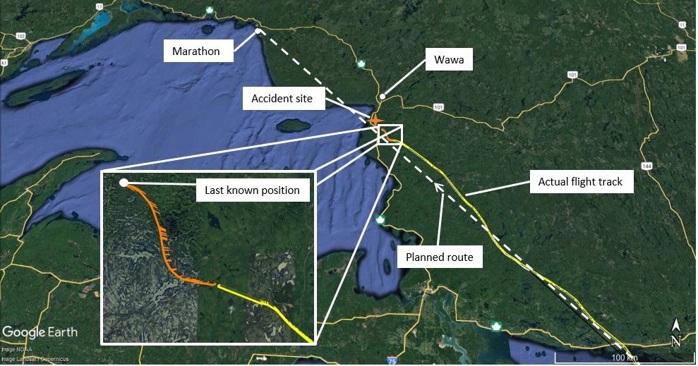
On 14 April 2022, the privately registered Piper PA24-250 (Comanche) aircraft (registration C-GEWK, serial number PA24-716) was conducting a visual flight rules (VFR) flight from Delhi Aerodrome (CDH6), Ontario, to Marathon Aerodrome (CYSP), Ontario, with the pilot and 1 passenger on board. The pilot filed a VFR flight plan at 1521,Footnote 1 with a planned route from CDH6 to Manitowaning/Manitoulin East Municipal Aerodrome (CYEM), Ontario, then to CYSP.
The aircraft departed at 1543 in visual meteorological conditions (VMC), heading toward CYEM. About 1 hour later, when the aircraft was in the vicinity of Wiarton, Ontario, a video of the onboard instrumentation was taken, which showed that the aircraft was at an altitude of 4900 feet above sea level. The video also showed that the flight was in VMC conditions at the time; however, dense clouds could be seen to the west of the aircraft’s track. The aircraft changed its heading slightly towards the west, in the direction of CYSP, just before flying over Manitoulin Island.
According to automatic dependent surveillance – broadcast (ADS-B) data obtained after the occurrence, the aircraft was flying toward CYSP at approximately 1758, but was starting to show more frequent heading changes. ADS-B position information was lost at approximately 1803, at which time the aircraft was approximately 14 nautical miles (NM) south of Wawa Aerodrome (CYXZ), Ontario, and the weather was deteriorating from VMC to instrument meteorological conditions (IMC).
No altitude information was reported via ADS-B, likely due to a problem with the aircraft’s altitude encoder.
At 1952, the NAV CANADA Flight Service Station in London, Ontario, informed the Joint Rescue Coordination Centre (JRCC) in Trenton, Ontario, that the aircraft was overdue. No signal had been detected by Cospas-Sarsat from the aircraft’s 406 MHz emergency locator transmitter (ELT).Footnote 2
The JRCC initially tasked a Canadian Armed Forces CH-146 Griffon helicopter and CC-130H Hercules airplane based in Trenton to start a visual and electronic search along the planned route from CYEM to CYSP. The search operation continued into the evening, to no avail. Poor weather conditions, including low ceiling, reduced visibilities, and snow showers, hampered the search for the next 5 days.
After 10 days of extensive searching led by the JRCC with the support of other governmental and private organizations, the Ontario Provincial Police (OPP) took over the search as a missing persons case.
On 21 May 2022, a helicopter operator involved in a private search identified what seemed to be aircraft parts in an open swampy area and notified the OPP. An OPP helicopter that was also conducting search operations in the area landed near the site and identified the parts as those of the occurrence aircraft. The crash site was 6 NM northwest of the aircraft’s last known position (Figure 1). The 2 occupants had been fatally injured. The aircraft was destroyed.
Aircraft information
The Piper PA24-250 is a low-wing, single-engine, 4-seat, small aircraft with retractable tricycle landing gear. The occurrence aircraft was manufactured in 1959 and had been purchased by the pilot on 12 January 2022.
The occurrence aircraft had accumulated approximately 4399 total hours since new and the last annual inspection had been conducted in April 2021 in accordance with Canadian Aviation Regulations Standard 625, Appendix B and Appendix C.
In January 2020, the aircraft had been modified to incorporate the L3 NGT-9000 ADS-B technology in accordance with Transport Canada Supplemental Type Certificate (STC) SA 16-50 and U.S. Federal Aviation Administration (FAA) STC SA02444AK. In April 2021, the aircraft had been modified to incorporate FAA STC SA01818WI (Garmin G5 electronic flight instruments). The aircraft was equipped with an S-TEC 55 autopilot; however, the investigation was unable to determine if the system was functional or if the pilot had received training or knew how to operate it.
Information collected at the accident site indicated that the aircraft was being operated within its weight and balance limitations.
Impact and wreckage information
The wreckage was found in a mountainous and densely wooded area 37 days after the aircraft went missing. The right wing’s outboard section had separated from the fuselage after an impact with a tree and was found approximately 170 m northeast of the main wreckage. The aircraft collided with terrain in an almost-inverted, vertical nose-down attitude.
The landing gear was found in the down and locked position and the flaps were still in the retracted position. The flight controls were examined to the extent possible and there was no sign of pre-impact discrepancies. The damage caused by the propeller to the surrounding trees is consistent with the engine developing power before the impact, although the amount of power could not be determined. Both occupants were found inside the wreckage.
The aircraft’s GPS (global positioning system) and ADS-B instruments were recovered and sent to the TSB Engineering Laboratory in Ottawa, Ontario; however, it was not possible to extract any data from them due to the damage caused by the impact.
The 406 MHz ELT and the aircraft’s main battery were found on the ground near the wreckage and had likely been ejected from the aircraft at impact, damaging internal and external components. The ELT was in the ARM position and the antenna cable was torn near the ELT connector, preventing signal transmission beyond a short distance. Further examination conducted on the ELT determined the following:
- The contact lead of the internal G-switch was damaged during impact, which prevented it from functioning properly.
- The mode switch contacts were damaged from the impact such that the ELT could not be manually switched to the ON position and did not activate automatically when in the ARM position.
- The ELT battery pack was sufficiently charged to transmit an emergency signal.
Pilot information
The pilot held a private pilot licence – aeroplane and his Category 3 medical certificate was valid. He had obtained his licence in October 2018 and had obtained a night rating in January 2019.
Records indicate that the pilot had accumulated approximately 114 hours of flying time, not including the occurrence flight. Of those hours, 4.2 were in the occurrence aircraft and another Piper PA24 aircraft. The remaining hours were on Piper PA28 aircraft. Records indicate that the pilot had received 19.2 hours of instrument flight training; however, he did not hold an instrument rating.
The investigation was unable to confirm whether the pilot had completed the 24-month recurrent training program stipulated in paragraph 401.05(2)(a) of the Canadian Aviation Regulations; however, he met the other recency requirements stipulated in section 401.05.
The passenger, who was seated in the right seat, also held a private pilot licence – aeroplane.
Weather information
The investigation was unable to determine what weather information the pilot obtained before departure. The nearest available weather information to the occurrence site was from CYXZ (11.5 NM north-northeast of the occurrence site). The amended aerodrome forecast (TAF) issued at 1003 indicated that the following conditions were expected from 1100:
- winds from 230° true (T) at 15 knots, gusting to 30 knots
- visibility 5 statute miles (SM) in light snow showers
- overcast ceiling at 2000 feet above ground level (AGL)
The following conditions were forecast from 1700:
- winds from 220°T at 12 knots, gusting to 22 knots
- visibility 1 SM in light snow showers
- scattered clouds at 800 feet AGL and an overcast ceiling at 2500 feet AGL
The following observed conditions were reported in a special weather report (SPECI) issued for CYXZ at 1806:
- winds from 210°T at 12 knots, gusting to 20 knots
- visibility 1 SM in light snow
- vertical visibility of 1000 feet
- temperature −1 °C, dew point −3 °C
Another SPECI, issued for CYXZ at 1809, indicated:
- winds from 220°T at 11 knots, gusting to 17 knots
- visibility ⅝ SM in light snow
- vertical visibility of 700 feet
- temperature −1 °C, dew point −3 °C
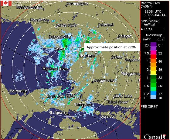
The Environment and Climate Change Canada weather radar showed snow precipitation moving over the occurrence area from the southwest at the time the last known position was recorded (Figure 2).
Observers at Lake Superior Provincial Park reported heavy snow showers commencing at 1630, 1.5 NM west of the aircraft’s last known position, about 1 hour and 30 minutes before the occurrence aircraft reached that position.
Visual flight rules in deteriorating weather conditions
The hazards associated with continuing VFR flight into IMC are well documented. As stated in the FAA’s Advisory Circular (AC) 61-134,
one of the leading causes of GA [general aviation] accidents is continued VFR flight into IMC. […] The result is often a CFIT [controlled-flight-into-terrain] accident when the pilot tries to continue flying or maneuvering beneath a lowering ceiling and hits an obstacle or terrain or impacts water. The accident may or may not be a result of a loss of control before the aircraft impacts the obstacle or surface. The importance of complete weather information, understanding the significance of the weather information, and being able to correlate the pilot’s skill and training, aircraft capabilities, and operating environment with an accurate forecast cannot be emphasized enough.Footnote 3
Accidents involving flights that depart under VMC and continue to a point where pilots lose visual reference with the ground have a high number of fatalities. According to data collected by the TSB, 100 of these types of accidents were recorded from 2000 to 2021, resulting in 122 fatalities in Canada.
TSB laboratory reports
The TSB completed the following laboratory reports in support of this investigation:
- LP056/2022 – NVM Recovery – Various Electronics
- LP060/2022 – ELT Analysis
Safety messages
VFR flights that continue into IMC often result in a collision with terrain or a loss of control due to lost visual references. Pilots are reminded to plan ahead, consider strategies to avoid adverse weather, and have alternate plans should such weather be encountered.
This report concludes the Transportation Safety Board of Canada’s investigation into this occurrence. The Board authorized the release of this report on . It was officially released on .