Collision with terrain
Great Slave Helicopters 2018 Ltd.
Airbus Helicopters AS350 B2 (helicopter), C-FYDA
Griffith Island, Nunavut
The Transportation Safety Board of Canada (TSB) investigated this occurrence for the purpose of advancing transportation safety. It is not the function of the Board to assign fault or determine civil or criminal liability. This report is not created for use in the context of legal, disciplinary or other proceedings. See Ownership and use of content. Masculine pronouns and position titles may be used to signify all genders to comply with the Canadian Transportation Accident Investigation and Safety Board Act (S.C. 1989, c. 3).
Executive summary
At approximately 1548 Central Daylight Time on 25 April 2021, the Great Slave Helicopters 2018 Ltd. Airbus Helicopters AS 350 B2 (registration C-FYDA, serial number 4157) departed from a remote camp on Russell Island, Nunavut, on a day visual flight rules (VFR) flight to Resolute Bay Airport, Nunavut, located 87 nautical miles to the northeast. On board were the pilot, an aircraft maintenance engineer, and a biologist. The purpose of the flight was to return to Resolute Bay following 12 days spent conducting polar bear research for a client, given that poor weather was forecast in the area for the next several days.
At approximately 1633 Central Daylight Time, the helicopter impacted the snow-covered terrain on Griffith Island, Nunavut, approximately 12 nautical miles southwest of Resolute Bay Airport, on a near-reciprocal track to the intended route. The helicopter was destroyed, and a post-impact fire consumed much of the fuselage area. The emergency locator transmitter was destroyed during the impact sequence and did not transmit a distress signal. There were no survivors.
In addition to the circumstances that most likely led to the collision with terrain resulting from a loss of visual references in flat light and whiteout conditions, the investigation examined the factors that likely influenced the pilot’s decision-making process, the organizational defences in place at Great Slave Helicopters 2018 Ltd., and the regulatory environment.
Pilot decision making
The investigation found that the Transport Canada Aeronautical Information Manual provides very little guidance to operators and pilots with regards to strategies to recognize and cope with flat light and whiteout conditions. As a result, pilots may lack vital information to avoid or deal with inadvertent flight into instrument meteorological conditions (IIMC), increasing the risk of collision with terrain. In this occurrence, the pilot’s limited experience operating above the tree line during the winter and spring months likely lowered his perception of risk, influencing the decision to continue flight over featureless snow-covered terrain under overcast skies and poor visibility, conditions that were conducive to flat light and whiteout.
Furthermore, when engaged in remote operations, it is important for companies to implement measures to ensure an adequate level of supervision and to ensure that resources are in place to support pilot decision making. On the day of the occurrence, the pilot likely placed considerable weight on the client’s assessment that the weather was suitable for the return flight to Resolute Bay Airport, leading him to believe that additional weather information and/or a formal weather briefing from a source like NAV CANADA was not needed. As a result, safety margins were inadvertently reduced. If operators informally defer to, or encourage pilots to rely on, clients for flight-following activities, there is an increased risk that pilots will not receive sufficient supervision and decision-making support, such as relaying of weather information.
Defences against inadvertent flight into instrument meteorological conditions
The investigation determined that when the helicopter, which was being operated under day VFR, approached the highest elevation on Griffith Island, the uniformly snow-covered and featureless terrain, an overcast sky, and snow squalls likely created flat light and whiteout conditions that resulted in instrument meteorological conditions. Then, while the pilot was likely attempting to visually manoeuvre the helicopter in response to IIMC, an unintentional descent resulted in the helicopter impacting the terrain on a near-reciprocal track to the intended route.
Training
In order to make optimal decisions, pilots rely on their experience and training to build situational awareness by actively seeking out relevant cues, understanding those cues, and anticipating how those cues could affect the flight. However, in this occurrence, the pilot’s decision to depart was based on an incomplete understanding of the weather forecasted along the intended route. As a result, it is likely that his inaccurate mental model diminished the perceived importance of contingency planning for adverse weather.
The current regulations for day VFR helicopter operations focus primarily on defences designed to avoid IIMC. As such, there was no requirement for the occurrence pilot to be trained to recover from an IIMC encounter.
Because there is no requirement for commercial helicopter operators to ensure that pilots possess the skills necessary to recover from IIMC, the pilots and passengers who travel on VFR helicopters are at increased risk of collision with terrain following a loss of visual references.
The TSB has previously called for requirements for verification of proficiency in basic instrument flying skills for commercial helicopter pilots during annual pilot proficiency flight checks. However, Transport Canada (TC) has yet to implement sufficient measures in this regard. Therefore, the Board recommends that
the Department of Transport require commercial helicopter operators to ensure pilots possess the skills necessary to recover from inadvertent flight into instrument meteorological conditions.
TSB Recommendation A24-01
Technology
Not only do the current regulations for day VFR helicopter operations not require pilots to be trained for IIMC recovery, they also do not require that aircraft used for these operations be equipped with technology that can assist with the avoidance of, and recovery from, IIMC. One of the most basic examples of this technology is flight instrumentation. In addition, several technological advances have emerged that can enhance pilot situational awareness and, therefore, assist in the reduction of IIMC accidents.
The TSB has previously attempted to address safety issues related to helicopter collision with terrain accidents, calling for increased requirements for flight instrumentation and other systems such as radar altimeters. To date, TC has not taken the measures needed to address these recommendations, which were issued more than 30 years ago. Therefore, the Board recommends that
the Department of Transport require commercial helicopter operators to implement technology that will assist pilots with the avoidance of, and recovery from, inadvertent flight into instrument meteorological conditions.
TSB Recommendation A24-02
Regulatory environment
Standard operating procedures
The investigation found that Great Slave Helicopters 2018 Ltd. adopted an approach consistent with the current regulations that relies on a pilot’s ability to avoid IIMC. As a result, the occurrence pilot lacked the skills to recover from IIMC. Standard operating procedures (SOPs) are widely accepted as a tool to enhance safety in multi-crew operations, and many of those same benefits apply equally to single-pilot operations. SOPs are particularly beneficial when a pilot lacks the knowledge or experience in a situation where a less-than-ideal course of action could reduce safety margins. However, single-pilot operations conducted under subparts 604, 702, 703, and 704 of the Canadian Aviation Regulations (CARs) are permitted without SOPs.
If SOPs for single-pilot operations are not required for CARs subparts 604, 702, 703, and 704 operators, those pilots may not be provided with vital decision-making support, increasing their potential to operate with levels of risk higher than necessary. Pilots and passengers who travel on those aircraft are consequently at increased risk of accident resulting from ineffective decision making and from cognitive workload in response to novel or unexpected situations. Therefore, the Board recommends that
the Department of Transport require operators conducting single-pilot operations under Subpart 604 and Part VII of the Canadian Aviation Regulations to develop standard operating procedures based on corporate knowledge and industry best practices to support pilot decision making.
TSB Recommendation A24-03
Helicopter requirements for reduced-visibility operations in uncontrolled airspace
Moreover, many VFR helicopter and airplane operators are approved by TC to conduct reduced-visibility operations in uncontrolled airspace. The approval, granted as an operations specification, outlines requirements that operators must meet to carry out reduced-visibility operations in uncontrolled airspace. Some of these requirements are the same for helicopters and airplanes; however, the requirements for visibility limits, aircraft equipment, and pilot training are less strict for helicopters than for airplanes. This is despite the fact that the TSB has determined that helicopter accidents are more than twice as likely to involve a loss of visual reference than are airplane accidents.
If regulations continue to allow commercial helicopter operators with the applicable operations specification to conduct reduced-visibility operations in uncontrolled airspace at lower visibility, and with significantly fewer defences, than commercial airplane operators, these helicopter operators will continue to be at a greater risk of collision with terrain as a result of loss of visual references. Therefore, the Board recommends that
the Department of Transport enhance the requirements for helicopter operators that conduct reduced-visibility operations in uncontrolled airspace to ensure that pilots have an acceptable level of protection against inadvertent flight into instrument meteorological conditions accidents.
TSB Recommendation A24-04
Safety management
Although not required by regulation, Great Slave Helicopters 2018 Ltd. implemented a system to manage safety—similar to a safety management system (SMS). An SMS allows companies to proactively manage safety through the timely identification of hazards that can reduce safety margins, and the implementation of defences to reduce those risks. The investigation determined that the risk management process at Great Slave Helicopters 2018 Ltd. overestimated the occurrence pilot’s level of operational readiness and the ability of existing defences to mitigate the risk posed by flat light and whiteout conditions. As a result, the occurrence pilot was dispatched to conduct remote operations, above the tree line, with insufficient safeguards to ensure adequate safety margins were maintained. If Transport Canada does not require all Canadian Aviation Regulations Part VII operators to have an SMS and does not evaluate these systems for effectiveness, there is a risk that operators will rely on inadequate processes to manage safety.
Safety action taken
Following the accident, Great Slave Helicopters 2018 Ltd. took several safety actions. These include a company-wide safety stand-down to ensure all personnel were safe to continue work; amendments to the SOPs following discussions with pilots about operating “in the white;” enhanced training and revised reference material related to overdue aircraft procedures; increased pilot recurrent training, with an emphasis placed on pilot decision making; several changes to its system for managing safety; the implementation of quarterly safety management meetings; and the creation a sub-committee that involves pilots and aircraft maintenance engineers in the review process of reports from its system used to manage safety.
1.0 Factual information
1.1 History of the flight
1.1.1 Background
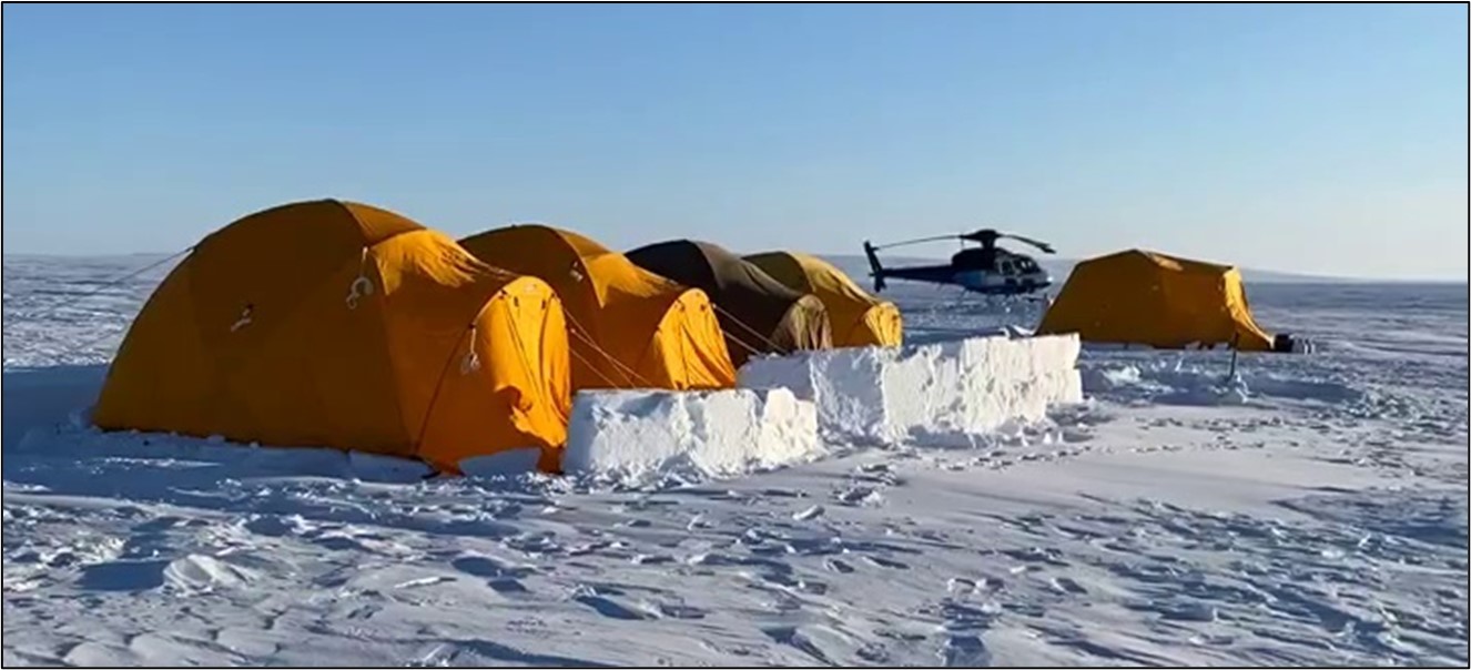
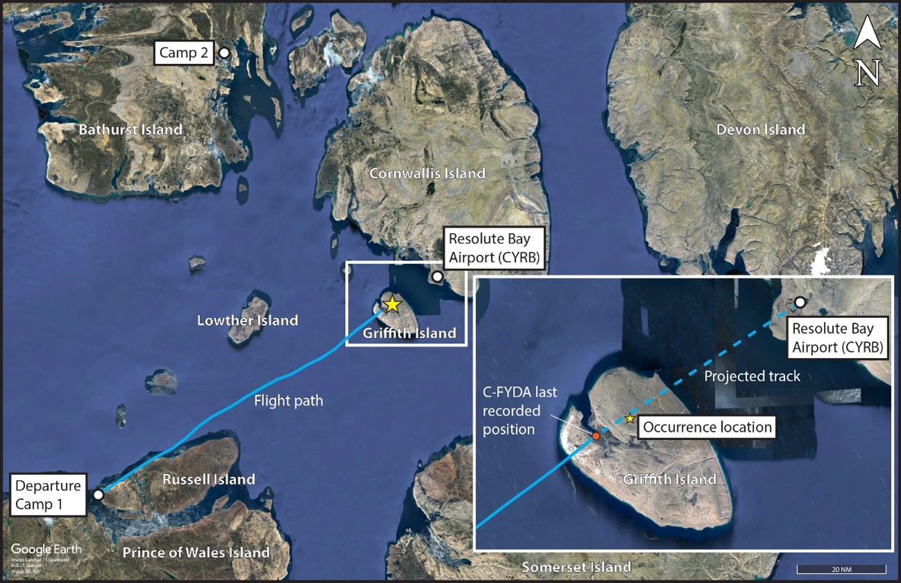
On 13 April 2021, an Airbus Helicopters AS 350 B2 (AS 350 B2), operated by Great Slave Helicopters 2018 Ltd. (GSH), flew from the Resolute Bay Airport (CYRB), Nunavut, to a remote campFootnote 1 (Camp 1 – Figure 1) on Russell Island, Nunavut, located approximately 87 nautical miles (NM) to the southwest. The helicopter operated from Camp 1 for the next 12 days conducting polar bear research under contract to the Polar Continental Shelf Program (PCSP).
At approximately 0715Footnote 2 on 25 April 2021, PCSP staff in Resolute Bay reviewed the actual and forecast weather for the region.Footnote 3 Although the weather at the camp was good, a low-pressure system was advancing from the southeast of, and towards, Resolute Bay. At approximately 0900, PCSP staff contacted the on-site (lead) biologist via satellite phone. The biologist initially inquired about relocating to Creswell Bay, Nunavut (approximately 120 NM southeast of Russell Island); however, because the approaching system would likely result in several no-fly days due to blizzard conditions, all parties agreed that it would be best to demobilize the camp and return to CYRB before the low-pressure system reached the area later that day. PCSP staff estimated that it would be 8 to 10 hours before the weather in the area would start to deteriorate. The biologist indicated that it would take approximately 4 hours to take down the camp, which would then be transported to CYRB using a de Havilland DHC-6 (Twin Otter). Therefore, PCSP staff believed that the helicopter would be back in Resolute Bay before the weather system reached the area. The helicopter pilot, who was the occurrence pilot, was not directly involved in these discussions with PCSP.
Shortly after the decision was made to demobilize Camp 1, the lead biologist messaged another biologist working at a camp (Camp 2) approximately 100 NM to the north-northeast (66 NM northwest of CYRB). The lead biologist indicated that it was sunny and that they might go flying until the demobilization was finished. The other biologist indicated that it was snowing at their camp, there was an overcast sky, and “completely flat” light conditions made it difficult to walk because of poor contrast (see section 1.18.2 Flat light and white out conditions).
At 1021, the occurrence pilot sent a satellite message to PCSP staff requesting the graphic area forecast (GFA) information for the area between the camp and Creswell Bay. Approximately 20 minutes later, before PCSP staff had responded to his message sent at 1021, the pilot messaged PCSP staff again to tell them they would be returning to CYRB that day. Approximately 1 minute later, PCSP staff replied, reporting that Creswell Bay was under an overcast cloud layer and the plan was to move camp back from Russell Island to Resolute Bay. The pilot acknowledged the message. No other information about the weather was exchanged between PCSP staff and the pilot. At 1111, the pilot informed GSH’s dispatch that they would be returning to CYRB by 1600.
At approximately 1130, the lead biologist informed PCSP staff, via satellite telephone, that the weather at the camp was still good. PCSP staff indicated that the weather in CYRB was still adequate for flight operations.
At 1245, a Twin Otter arrived at Camp 1 on Russell Island. The pilot of the Twin Otter had a brief discussion about the weather with someone at the camp; however, it could not be established if it was the lead biologist or the occurrence pilot. The extent of the exchange of information was that the weather was “decent” at CYRB but not as nice as it was at the camp. The Twin Otter was then loaded with camp gear and departed for CYRB at 1315. The plan was to offload the gear at CYRB and then return to the camp, transport 3 local guides to Arctic Bay, Nunavut, and then bring the remaining gear from the camp back to CYRB.
At approximately 1330, the lead biologist sent a message to the other biologist at Camp 2, stating that they were demobilizing Camp 1 and heading back to CYRB. The biologist at Camp 2 indicated that the current lighting condition there was “flat, flat, flat” and that the visibility was “terrible.”
At 1520, the Twin Otter arrived back at Camp 1, from Resolute Bay. The remaining gear was loaded and the local guides boarded the airplane, which departed at 1541 for Arctic Bay.
1.1.2 Occurrence flight
At 1548, the occurrence helicopter departed Camp 1 on a visual flight rules (VFR) flight to CYRB (Figure 2).Footnote 4 The occurrence flight track to CYRB took the helicopter above a mix of solid ice and ice chunks (i.e., ice pans) between Russell Island and Griffith Island, Nunavut.Footnote 5 On board were the pilot, an aircraft maintenance engineer, and the lead biologist. Approximately 3 minutes after takeoff, a message originating from the pilot’s satellite messenger was sent to GSH’s dispatch and PCSP staff, reporting that the helicopter had departed and estimated arriving at CYRB at 1645.
For the first 25 minutes of the flight, the helicopter was generally flown at 110 knots, from 250 feet to 1000 feet above sea level (ASL). From the camp until the eastern edge of Russell Island, the helicopter’s track was consistent with a direct track from the camp to CYRB. During the first half of the portion of the flight between Russell Island and Griffith Island, the helicopter’s track diverged 1.0 to 1.5 NM left of the direct track. Approximately halfway between Russell Island and Griffith Island, the helicopter’s track altered to the right, until the helicopter was approximately 1 NM right of the direct track, 15 NM west of Griffith Island. From that point, the helicopter, which was flying from 90 to 100 knots and descending steadily, began converging with the direct track. Just before reaching the western edge of Griffith Island, at an altitude of approximately 250 feet ASL, the helicopter was on the direct track between the camp and CYRB.
At 1626, the helicopter was approximately 20 NM southwest of CYRB, and 4 NM from the western edge of Griffith Island. At that point, the pilot transmitted a position report on frequency 126.7 MHz, stating that the helicopter was 20 NM from the airport and estimated arriving at CYRB in 14 minutes. Moments after this radio transmission, the lead biologist began using his satellite messenger to coordinate logistical requirements with PCSP.
At 1631, the helicopter was approximately 2 NM inland of the southwestern edge of Griffith Island. This was the helicopter’s last recorded position. At that point, the helicopter was flying at 94 knots and at approximately 850 feet ASL. The helicopter’s track to CYRB would result in overflying a perpendicular ridgeline with an elevation of 530 feet ASL, which coincided with the highest elevations on Griffith Island. Based on the aircraft satellite flight tracking system information, the pilot had flown a similar (direct) track, in the opposite direction, across Griffith Island on 13 April 2021, when flying from CYRB to Camp 1.
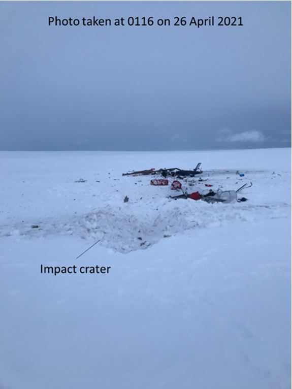
Approximately 2 minutes later, before reaching the ridgeline, the helicopter collided with the snow-covered terrain on Griffith Island, at an elevation of approximately 370 feet ASL (Appendix A). The helicopter wreckage was located approximately 2 NM beyond the last recorded position, and 12 NM southwest of CYRB, approximately 0.33 NM south of the direct track to CYRB, oriented on a near-reciprocal track.
1.1.3 Search and rescue effort
At approximately 1655, the PCSP staff member monitoring the web-based satellite flight-tracking system noticed that the occurrence flight’s status icon changed from yellow to purple. The PCSP staff member initially understood this to represent a change in status from “in-flight” to “on-ground and in mission.” In the absence of any other communications or reports of an emergency locator transmitter (ELT) signal,Footnote 6 it was believed that the pilot likely landed due to the deteriorating weather. At around the same time, another PCSP staff member, who was leaving for the day, noticed that the weather had deteriorated significantly in the direction of Griffith Island. Light snow was falling in Resolute Bay, the sky condition was overcast, and a large snow squall was observed between Resolute Bay and Griffith Island. The area was under flat light conditions, resulting in poor contrast. Concerned about the helicopter, this PCSP staff member returned inside and at 1657, PCSP staff sent a message to the pilot stating that there was limited visibility at CYRB at the moment due to a snow squall. There was no reply.
At 1726, PCSP staff attempted to contact the biologist on the occurrence helicopter, also via satellite messenger; however, there was no reply. At approximately the same time, GSH flight followers, who had also noticed the change in satellite tracker status, attempted to contact the occurrence pilot via satellite messenger. At this point, GSH and PCSP staff began coordinating efforts to find the occurrence helicopter. Shortly thereafter, the RCMP (Royal Canadian Mounted Police), local search and rescue (SAR) personnel, and the Joint Rescue Coordination Centre (JRCC) in Trenton, Ontario, were informed of the situation.
PCSP dispatched a local Twin Otter to the last known position, and at 1912, the pilot of the Twin Otter radioed back to PCSP that a crash site had been located on Griffith Island. A couple of hours later, local SAR personnel departed CYRB on snowmobiles. Ground SAR personnel experienced difficulties locating the wreckage due to poor weather conditions near the accident site. At approximately 0100 on 26 April 2021, ground SAR personnel located the crash site and confirmed there were no survivors.
1.2 Injuries to persons
There were 1 flight crew member and 2 passengers on board. Table 1 outlines the degree of injuries received.
| Degree of injury | Crew | Passengers | Persons not on board the aircraft | Total by injury |
|---|---|---|---|---|
| Fatal | 1 | 2 | – | 3 |
| Serious | 0 | 0 | – | 0 |
| Minor | 0 | 0 | – | 0 |
| Total injured | 1 | 2 | – | 3 |
1.3 Damage to the aircraft
The helicopter was destroyed as a result of impact forces and post-impact fire.
1.4 Other damage
There was no other damage.
1.5 Personnel
1.5.1 General
| Pilot licence | Commercial pilot licence (helicopter) |
|---|---|
| Medical expiry date | 01 May 2022 |
| Total flying hours | Approximately 4050 |
| Flight hours on type | Approximately 1700 |
| Flight hours in the 24 hours before the occurrence | Approximately 0.75 |
| Flight hours in the 7 days before the occurrence | 6.5 |
| Flight hours in the 30 days before the occurrence | 50.3 |
| Flight hours in the 90 days before the occurrence | 123.3 |
| Flight hours on type in the 90 days before the occurrence | 123.3 |
| Hours on duty before the occurrence | 9 |
| Hours off duty before the work period | 12+ |
The occurrence pilot held a valid Canadian commercial pilot licence – helicopter, restricted to daylight VFR flying. The pilot had type ratings on the Bell 206, AS 350, and Robinson R44 helicopters. The pilot joined GSH in March 2019 and flew with the company, on a short-term basis due to seasonal demand, until December 2019. In March 2020, he rejoined GSH and remained at GSH up until the time of the occurrence. The investigation determined that the majority of the occurrence pilot’s flights were daily missions originating from, and terminating at, either the Yellowknife Airport (CYZF), Northwest Territories, or other regional airports during the summer months. His prior employment as a helicopter pilot did not include flying above the tree line.Footnote 7
Since 2008, the occurrence pilot had acquired 16.4 hours of instrument flight training, conducted in aircraft and in simulators. Approximately 10 of those hours were completed in 2015 during helicopter training. The remaining hours were completed during fixed-wing training in 2008-2009 (2.8 hours), 2017 (2.3 hours), and 2021 (1.2 hours).
The pilot’s most recent pilot proficiency check was conducted on the occurrence helicopter on 27 October 2020. Records indicate that the pilot held the appropriate licence and ratings for the flight in accordance with existing regulations.
1.5.2 Overview of occurrence pilot’s training file
In October 2020, the occurrence pilot completed the company’s annual ground training, which included pilot decision making (PDM), crew resource management (CRM), and low-visibility operations training. The training met the applicable regulatory requirements.
On 26 October 2020, the occurrence pilot completed the in-flight portion of the company’s annual low-visibility operations training. The training took 0.3 hours to complete and consisted of low-speed manoeuvring and a 180° course reversal at low speed.
1.5.3 Occurrence pilot’s previous experience above the tree line
Before April 2021, the pilot’s experience in operating above the tree line during the spring or winter, while snow was on the ground,Footnote 8 was acquired primarily as follows:
- 28 to 29 April 2019 (approximately 20 flight hours in total): Animal capture flights operated out of the Arviat Airport (CYEK), Nunavut. For training purposes, the occurrence pilot was accompanied by another GSH pilot with considerable experience above the tree line.
- 18 April 2020 (4.4 flight hours): The occurrence pilot flew with a wildlife enforcement officer from CYZF to a lake above the tree line and then back to CYZF.
- 21 April 2020 to 12 May 2020 (approximately 76 flight hours in total): Two GSH helicopters engaged in local animal capture/culling flights out of CYZF. At times, these flights crossed the tree line. The second helicopter was flown by the pilot who had accompanied the occurrence pilot for the animal capture flights in 2019.
Historical weather information revealed that most of the above flights were conducted in partly sunny to sunny conditions. On 2 occasions, during the 2020 capture/culling flights, the occurrence pilot and the pilot in the second helicopter elected to return to CYZF due to adverse weather conditions. On one other day, poor weather resulted in a no-fly day.
In addition to the work outlined above, the occurrence pilot spent approximately 5 weeks combined operating above the tree line during the summers of 2019 and 2020. The pilot stayed in camps varying from tents to hard-wall structures.
The polar-bear research operation was the first time the occurrence pilot worked from a remote location for an extended period of time, and it was his first time operating from a remote location above the tree line during the winter or spring months.
1.6 Aircraft information
1.6.1 General
| Manufacturer | Airbus Helicopters |
|---|---|
| Type, model and registration | AS 350 B2, C-FYDA |
| Year of manufacture | 2006 |
| Serial number | 4157 |
| Certificate of airworthiness | 16 March 2007 |
| Total airframe time | 8250.5 hours |
| Engine type (number of engines) | Safran Arriel 1D1 Free turbine, turboshaft (1) |
| Rotor type (number of blades) | Starflex semi-rigid (3) |
| Maximum allowable take-off weight | 2250.27 kg |
| Recommended fuel types | Jet A, Jet A-1, Jet B |
| Fuel type used | Jet A |
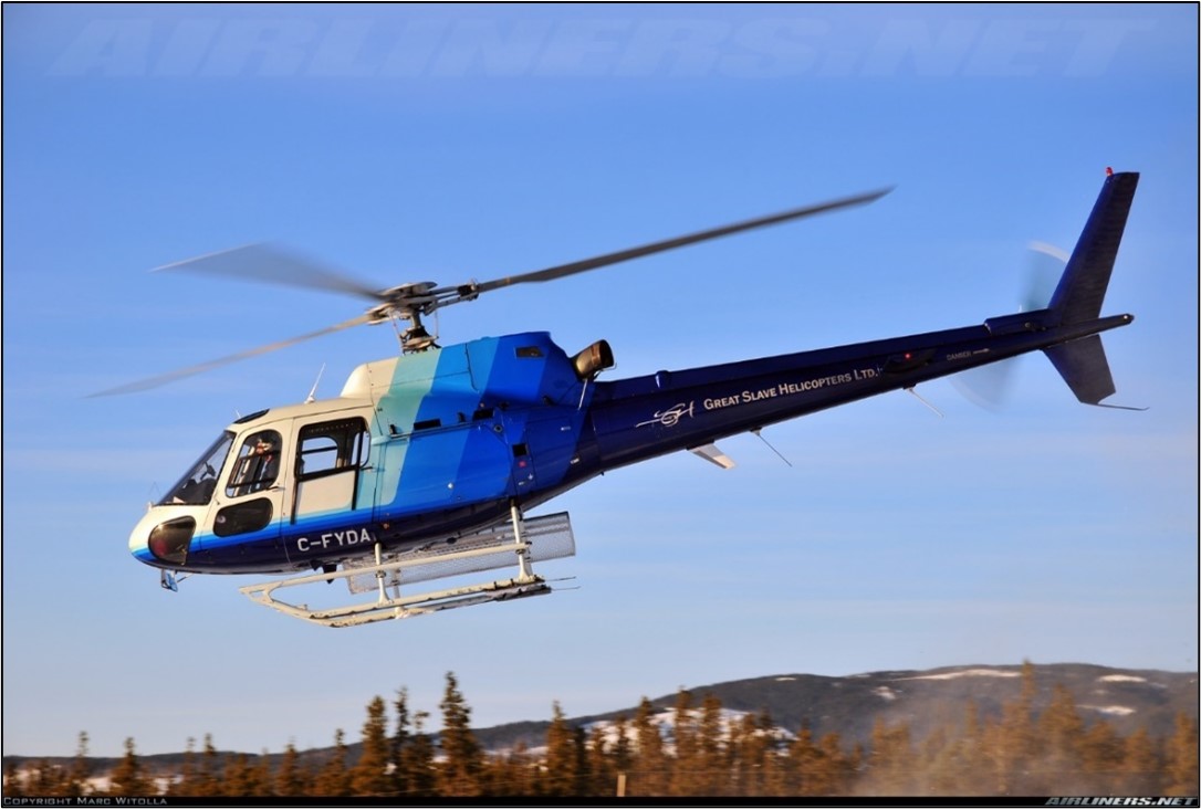
The Airbus Helicopters AS 350 B2 is a 6-seat, single-pilot, single-turbine-powered helicopter (Figure 3). It has a 3-blade counter-clockwise rotating main rotor. The pilot flies from the right seat. The occurrence helicopter was equipped with an external cargo basket installed on the left side of the helicopter.
Based on available information about equipment and personnel onboard the helicopter, the helicopter’s weight and centre of gravity were within the prescribed limits.
At the time of the occurrence, there were no documented defects in the helicopter’s journey log, which was recovered from the wreckage. The last entry in the journey log, dated 12 April 2021, was a maintenance inspection that had been carried out by the aircraft maintenance engineer who was on the occurrence flight.
1.6.2 Flight instruments
The helicopter was certified and equipped for daytime VFR flight in accordance with section 605.14 of the Canadian Aviation Regulations (CARs). Flight instrumentation included an airspeed indicator, an artificial horizon that incorporated a ball-in-tube slip and skid indicator, a barometric altimeter, Footnote 9 a VHF (very high frequency) omnidirectional range (VOR)/instrument landing system receiver and display, a gyroscopic direction indicator, and a vertical speed indicator.
The helicopter was not equipped with any type of autopilot, stability augmentation system, or radar altimeter, nor was it required by regulation for VFR flight operations.
1.6.3 Fuel pressure caution light
On the day of the occurrence, the pilot conducted a local VFR flight with the guides who were assisting at Camp 1 (see section 1.18.10 Videos taken on the day of the occurrence).
Videos taken by passengers show that the fuel pressure caution light was illuminated during the flight. This yellow caution light indicates that fuel pressure is lower than 0.2 bar at one or both of the helicopter’s 2 fuel boost pumps. Footnote 10 The helicopter’s fuel pressure reading was normal, which, according to the emergency procedure, means that 1 boost pump is faulty. Footnote 11 Flight can be continued with this condition. If the fuel pressure were zero, it would indicate that both pumps are faulty; however, flight can continue at an altitude below 5000 feet. Footnote 12 There was no record of this problem in the helicopter’s journey log, and it was not reported to GSH.
Based on the post-occurrence examination of the engine, combined with an analysis of the crash site, and based on the fact that fuel pressure indications were normal during the preceding flight, the illumination of the low fuel pressure caution light was not considered to have played a role in this occurrence.
1.7 Meteorological information
1.7.1 General
The Arctic experiences some of the harshest and most rapidly changing weather conditions in Canada. This is particularly true during the Arctic spring season, which is often characterized by unpredictable weather changes and frequent snow storms and blizzards that may persist for days.Footnote 13
1.7.2 Sources of aviation weather for Arctic operations
Due to its sparse population, Nunavut has limited weather reporting facilities. As a result, pilots flying in Nunavut are required to seek out, and synthesize, weather information from a variety of different sources, potentially hundreds of nautical miles away. Some of those sources of weather information include:
- GFAs, which may cover hundreds of nautical miles;
- visible and infrared satellite imagery, which may provide some indication of cloud cover and/or approaching weather systems;
- aviation weather forecasts and reports issued for airports potentially hundreds of nautical miles away;
- reports from other pilots;
- reports from other personnel; and
- the weather as observed by the pilot.
In many cases, pilots obtain weather information from an internet-based service, such as NAV CANADA’s flight planning website.Footnote 14 If pilots do not have internet access, or if they would like a weather briefing from a qualified specialist, they can call NAV CANADA’s toll-free flight planning phone number.Footnote 15 While operating at Camp 1, the occurrence pilot did not have internet access; however, he did have a satellite telephone. According to NAV CANADA, there were no communications with the pilot from 13 April to 25 April 2021.
When pilots rely on non-NAV CANADA personnel (i.e., other pilots or anyone else) for weather information to assist in their decision making, it is important to consider factors such as the experience and training of these other people and the type of flight operations they are accustomed to (i.e., airplane versus helicopter). For example, an instrument-flight-rules (IFR)-rated airplane pilot, who may be able to fly through poor weather by relying solely on the flight instruments, will not have the same concerns that a VFR-only helicopter pilot will have. The same applies when weather information originates from personnel who are not qualified weather observers or from company-trained flight followers. Information received from other personnel can assist PDM; however, pilots must ensure they have all the information needed to develop an accurate understanding of the weather.
The weather, as observed by pilots before and during a VFR flight, plays an important role in PDM. During a VFR flight, pilots must continually assess the weather and modify their plan, as required, if deteriorating weather conditions are encountered.
1.7.3 NAV CANADA meteorological information
1.7.3.1 General
According to The Weather of Nunavut and the Arctic – Graphic Area Forecast 36 and 37, during the winter months, a northerly flow can bring fog and low cloud into the Resolute Bay area. If there is a strong northwesterly flow, “there can be blowing snow and depending on the amount of snow upstream and the strength of the winds, the blowing snow can constitute a blizzard.”Footnote 16 In the spring, as the ice begins to break apart and/or melt, it creates open areas of water. The open water results in the addition of moisture to the lowest levels of the atmosphere, which can create areas of low cloud and fog. As cold air flows across the open water, the air mass becomes unstable and can produce localized convective cloud and snow squalls, which can result in areas of extremely poor visibility.
The closest weather reporting station to Camp 1 was CYRB, 87 NM to the northeast. It issues aerodrome forecasts (TAFs)Footnote 17 and aerodrome routine meteorological reports (METARs). The next 3 closest aviation weather reporting stations, i.e., airports, were more than 250 NM from Camp 1.Footnote 18 As a result, the primary source of aviation weather forecast information for the camp location was the GFAs, issued by NAV CANADA every 6 hours.
The investigation found no indication that, on the day of the occurrence, the pilot received a weather brief that included specifics found in the GFAs, TAFs, or METARs for CYRB.
1.7.3.2 Graphic area forecast
The Clouds and Weather Chart from the GFA valid at 0700 on the day of the occurrence, and consulted by PCSP staff when deciding to demobilize the camp, showed an approaching low-pressure system from the southeast. The GFA identified 3 areas of weather between the camp and CYRB (Appendix B, Figure B1). Table 4 provides a broad overview of the forecast weather between CYRB and Camp 1.
| Region | Forecast weather |
|---|---|
| Area 1 – Camp 1 |
|
| Area 2 – Eastern edge of Russell Island to just west of CYRB |
|
| Area 3 – CYRB |
|
The Clouds and Weather Chart from the GFA valid at 1300 on the day of the occurrence (Appendix B, Figure B2) showed the low-pressure system had advanced farther west towards Camp 1. The first and second halves of the occurrence track were then respectively under the general influence of the weather associated with area 2 and area 3 defined in Table 4 above, with slight improvements to the forecasted weather in area 3. In particular, area 3 showed an increase in forecast visibility (i.e., generally greater than 6 SM and patchy visibilities from 3 SM to 6 SM) along with patchy ceilings based from 800 feet AGL to 1500 feet AGL.
1.7.3.3 Aerodrome forecast for Resolute Bay Airport
| Time | 0700 to 1300* | 1300 until after the accident** |
|---|---|---|
| Wind | 8 kt from the east. | 10 kt from the east. |
| Visibility | 3 SM in light snow and mist. | 5 SM in light snow. |
| Sky condition | Overcast ceiling based at 700 feet AGL. | Broken ceiling based at 1200 feet AGL and an overcast cloud layer based at 3000 feet AGL. |
| Temporary conditions | Visibility greater than 6 SM in light snow; scattered clouds based at 800 feet AGL, and an overcast ceiling based at 2000 feet AGL. | Visibility greater than 6 SM in light snow; scattered clouds based at 1200 feet AGL, and an overcast ceiling based at 3000 feet AGL. |
* Information taken from CYRB TAF issued at 0715 Central Daylight Time.
** Information taken from CYRB TAF issued at 1238 Central Daylight Time.
1.7.3.4 Reported weather at the Resolute Bay Airport
On 25 April 2021, the reported weather at CYRB remained fairly steady throughout most of the day (Table 6):
| Wind (Direction/ speed) | Visibility (SM) | Sky condition | Temperature (°C) | Dew point (°C) | Altimeter (inHg)/Remarks |
|---|---|---|---|---|---|
| Easterly at 7 to 10 kt | 10–12 SM in light snow | Multiple broken/overcast cloud layers from 800 feet AGL to 3400 feet AGL | −4 °C to −7 °C | 2 to 3 °C below reported temperature | 30.05 at 0700; increasing approximately 0.01 inHg per hour until the occurrence |
1.7.4 Impact of weather on flying operations at Camp 1
| Date(s) | Activity |
|---|---|
| 14 to 17 April 2021 | Weather suitable – local flying |
| 18 to 21 April 2021 | Flat light and blizzard conditions – no flying |
| 22 April 2021 | Poor visibility – partial fly day |
| 23 April 2021 | Weather suitable – local flying |
| 24 April 2021 | Blizzard conditions – no flying |
| 25 April 2021 | Weather suitable – pilot conducted a short local flight approximately 1 hour before departing on the occurrence flight |
A video obtained from the morning of the occurrence, at Camp 1, shows a thin scattered-to-broken layer of mid-to-high level clouds. Some patches of sun are visible through the clouds and the visibility appears to be greater than 6 SM.
At Camp 2, the helicopter had not flown for almost 10 days before the occurrence. According to the company, this was because of snow, overcast skies, wind, and whiteout conditions (see section 1.18.2 Flat light and whiteout conditions).
1.7.5 Observed weather in the vicinity of Griffith Island and Resolute Bay on the day of the occurrence
During interviews conducted post-occurrence, pilots who had operated in and around the areas of Resolute Bay and Griffith Island on the afternoon of 25 April 2021 reported rapidly changing weather throughout the day, generally worse than reported in the hourly METARs at CYRB. They also reported visibilities ranging from 2 to 10 SM in light to moderate snow, broken to overcast cloud layers based from 1000 to 3000 feet AGL, and flat light conditions resulting in poor contrast. In some cases, pilots were required to deviate left and right of track to go around and/or avoid areas of reduced visibility, low ceilings, and snowfall. At approximately 1620, a pilot flew just south of Griffith Island, en route to CYRB. At the time, visibility was 2 to 3 SM, in light to moderate snow, with broken ceilings based at 1500 feet ASL. This is consistent with the weather observed by PCSP staff at around the time of the occurrence, and with the weather forecasted in the GFA for that region.
Approximately 3.5 hours after the occurrence, the Twin Otter pilot who was dispatched to the helicopter’s last known position on Griffith Island reported very poor surface contrast due to flat light conditions. The Twin Otter pilot elected to climb to 2000 feet AGL in order to better see the outline of Griffith Island.
1.8 Aids to navigation
The helicopter was equipped with a Garmin GNS 430 GPS and a Garmin GPSMAP 196, both possessing moving-map capability to allow for real-time position information relative to surrounding terrain. Neither of the aircraft’s GPSs had terrain awareness and warning system (TAWS) capability, nor was it required by regulation. A video taken during a flight just before the occurrence flight showed the Garmin 430 on and the Garmin GPSMAP 196 off. The Garmin GPSMAP 196 is capable of storing previous flight tracks; however, the last recorded data was from 06 April 2021.
1.9 Communications
The occurrence pilot and the lead biologist used a Garmin inReach satellite communication messaging device while at Camp 1. The satellite messages from those devices assisted in establishing a timeline of events and in understanding the operational challenges (e.g., adverse weather) encountered at the camp. The pilot’s device had nightly periods of inactivity of 9 to 12 hours, consistent with a period of rest or sleep.
The occurrence pilot had a portable satellite telephone. It was not used during deployment.
1.10 Aerodrome information
Not applicable.
1.11 Flight recorders
1.11.1 General
The helicopter was not equipped with a cockpit voice recorder (CVR) or a flight data recorder (FDR), nor was it required to be by regulation.
1.11.2 Satellite tracking system
The helicopter was equipped with a Latitude Technologies Corporation SkyNode S100 (Skynode S100) satellite flight-tracking system, which is not required by regulation. The SkyNode S100 captures and transmits flight information, based on available GPS data, to a web-based service at 2-minute intervals. The system was destroyed; however, the following information was retrieved from the web-based service:
- Time – at the time of each position reported
- Position (latitude and longitude) – at 2-minute intervals
- Ground speed (in knots) – the average speed between successive points
- Heading (°) – the true track, reported as heading, between successive points
- Altitude (in feet ASL) – typically accurate to within ± 30 feet
The web-based service can be used for flight-following purposes or to retrieve flight information from previous flights.
1.12 Wreckage and impact information
1.12.1 Griffith Island
Griffith Island measures approximately 11 NM by 6.75 NM. When approaching the island from the location of Camp 1, there is a ridgeline, perpendicular to the helicopter’s recorded track, that reaches an elevation of just below 300 feet ASL. Beyond that ridgeline is an inlet, followed by gradually rising terrain that forms another ridgeline, perpendicular to the track, reaching a maximum height of approximately 500 feet ASL, according to the VFR Navigation Chart.Footnote 19 Beyond the top of the ridgeline, the terrain slopes down to the water.
1.12.2 Deployment delays due to COVID-19
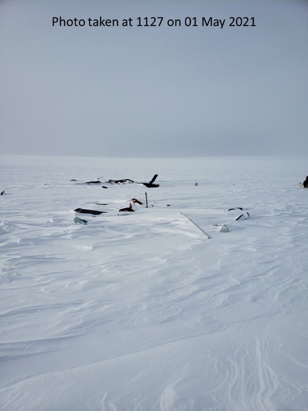
Due to the location of the accident and the challenges associated with the COVID-19 global pandemic, investigators travelled to the crash site on 01 May 2021. However, photos were taken by SAR personnel several hours after the accident, providing investigators with valuable information about the impact sequence (figures 4 and 5).
1.12.3 Occurrence site
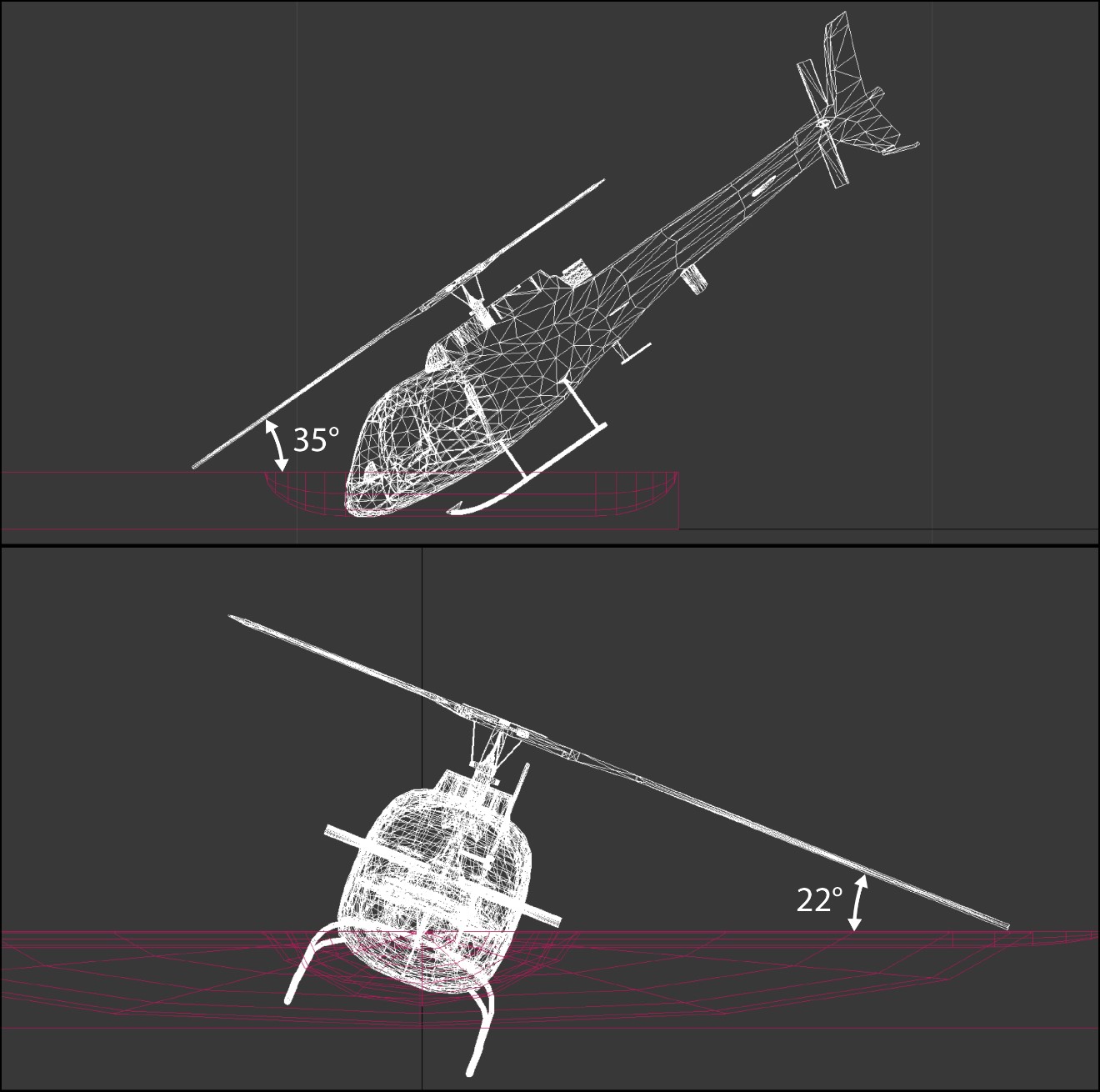
At the time of the occurrence, the ground was covered in more than 2 feet of snow. When ground SAR personnel reached the accident site, there was a coating of snow on most of the debris, from snow that had fallen since the accident. The fan-shaped crash site measured approximately 175 feet in length, and consisted of 4 main sections. The debris field was oriented on a track almost 180° to the occurrence flight’s track towards CYRB. All debris was found beyond the initial impact crater in the snow.
Ground SAR personnel who responded observed undisturbed snow to the sides of, and leading up to, the initial impact mark. The TSB laboratory used the available data and determined that the helicopter’s pitch attitude and bank angle would have had to have been less than 35° and 22° respectively not to have left blade marks in the snow, assuming that the main-rotor blades were straight and not coningFootnote 20 (Figure 6). The extent of the damage and the length of the debris field were consistent with the helicopter impacting terrain with a relatively high horizontal and vertical speed. These impact characteristics are most commonly associated with a controlled-flight-into-terrain (CFIT) accident rather than a loss-of-control accident (which is generally associated with a lower horizontal speed due to a steeper vertical descent).Footnote 21
The helicopter’s engine along with several other aircraft components, including the tail rotor gearbox and tail rotor blades, several flight instruments, and the warning annunciator panel, were recovered and transported to the TSB Engineering Laboratory in Ottawa, Ontario, for further examination. No pre-impact anomalies were found that would have precluded normal operation. The examinations determined that the engine was operating and producing significant power, and that the helicopter was operating at 100% main-rotor rpm at the time of impact. Damage to the main-rotor blades was also consistent with a significant amount of power being applied at the point of impact.
1.13 Medical and pathological information
According to information gathered during the investigation, there was no indication that the pilot’s performance was affected by medical or pathological factors, or fatigue.
1.14 Fire
The aircraft was destroyed by impact forces and a post-impact fire.
1.15 Survival aspects
The accident was not survivable.
1.15.1 Emergency locator transmitter
The occurrence aircraft was equipped with a Kannad 406-MHz automatic fixed helicopter (AF-H) ELT (part number S1822502-02, serial number LX11003329026). The ELT was certified to meet the legacy requirements of Technical Standard Order TSO-C126 issued in 1992 by the Federal Aviation Administration (FAA) of the United States (U.S.). The ELT was destroyed during the impact sequence and post-impact fire before it could transmit a distress signal to the SAR satellite system.
1.15.1.1 Previous TSB recommendation on emergency locator transmitter crash survivability standards
In response to ELT crash survivability issues identified during the investigation of an accident involving a Sikorsky S-76 helicopter on 31 May 2013 in Moosonee (CYMO), Ontario,Footnote 22 the TSB recommended that
the Department of Transport establish rigorous emergency locator transmitter (ELT) system crash survivability requirements that reduce the likelihood that an ELT system will be rendered inoperative as a result of impact forces sustained during an aviation occurrence.
TSB Recommendation A16-05
In response, Transport Canada (TC) amended the CARs to require that, as of 07 September 2020, new applications for design approval of an ELT meet the latest Canadian Technical Standard Order CAN-TSO-C126c.
In its March 2021 reassessment of TC’s response, the Board considered that the actions taken by TC will significantly reduce the risks associated with the safety deficiency identified in Recommendation A16-05. Therefore, the Board considered the response to Recommendation A16-05 to be Fully Satisfactory. Footnote 23 However, the TSB noted that these new standards do not apply to legacy ELTs.
1.16 Tests and research
1.16.1 TSB laboratory reports
The TSB completed the following laboratory reports in support of this investigation:
- LP054/2021 – NVM Data Recovery
- LP061/2021 – Instruments Analysis
- LP062/2021 – Warning and Caution Annunciators Analysis
- LP067/2021 – Helmet Review
- LP110/2021 – Engine Examination
1.17 Organizational and management information
1.17.1 General
Great Slave Helicopters 2018 Ltd. (GSH) was established in 2018 after acquiring the assets from the original Great Slave Helicopters company.Footnote 24
GSH’s main office is located in Yellowknife, Northwest Territories. The company has operating bases in the Northwest Territories, the Yukon, Saskatchewan, Alberta, and British Columbia.Footnote 25
At the time of the occurrence, GSH held operating certificates for operations under CARs Subpart 702 (Aerial Work) and Subpart 703 (Air Taxi Operations). GSH provides day VFR helicopter support to drilling operations, seismic activities, class D operations (external load), forestry activities, geophysical surveys, and other utility-related operations. The occurrence flight was being conducted under CARs Subpart 702.
Since its creation, GSH has averaged approximately 4500 flight hours per year. It does not conduct any night VFR or IFR operations.
At the time of the occurrence, GSH employed 35 pilots, 27 maintenance personnel, 21 support personnel, and 9 management staff.
1.17.2 Management team
On the operational side of GSH, a Chief Operating Officer (COO) reports directly to the Chief Executive Officer/Accountable Executive (Figure 7). The COO is responsible for the day-to-day operation of the company. The COO had previously worked at the original Great Slave Helicopters, from 2013 until the change of ownership in November 2018. In the 3 years leading up to the change of ownership, the COO occupied the position of Northern Regional Manager, essentially responsible for the company’s operations in the North. After the change of ownership, the COO assumed his current role with GSH. The COO has a logistics background and has worked around aviation, in different non-flying capacities, for more than 20 years.
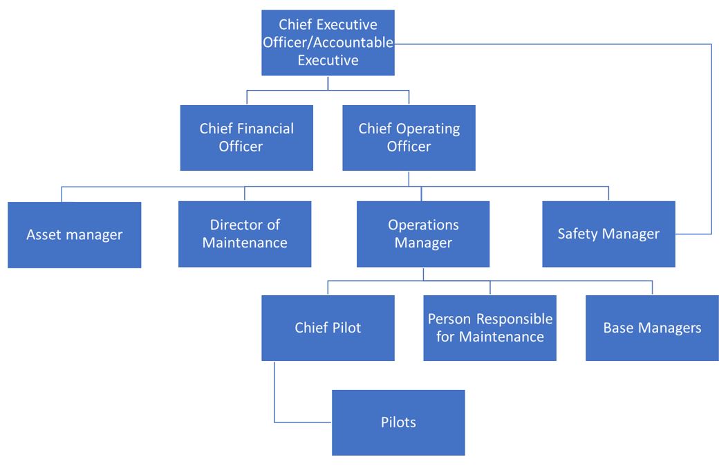
The pilots on GSH’s management team are day VFR helicopter pilots. The Operations Manager (OM), who reports directly to the COO, began his helicopter career in 2007 as a helicopter pilot at the original Great Slave Helicopters company. The OM worked for the original Great Slave Helicopters company or a subsidiary company, in different roles including line pilot, Base Manager and Northern Regional Manager. When the company changed ownership in November 2018, the OM assumed his current role at GSH. At the time of the occurrence, the OM had approximately 3000 total flight hours.
GSH also had an Assistant OM, who assumed that position in March 2021, 1 month before the accident. Like the OM, the Assistant OM began his helicopter career at the original Great Slave Helicopters company, where he worked from 2004 until the company changed ownership. While at the previous company, he held the position of Assistant OM from 2011 until February 2016, when he assumed the position of OM until the change of ownership. Before the change, he recommended, to the new owners, the current GSH OM for that position. Following the change, he worked elsewhere as a helicopter pilot until returning to GSH as Assistant OM. At the time of the occurrence, he had accumulated approximately 5500 total flight hours. In September 2021, the Assistant OM assumed the role of Acting Chief Pilot and formally assumed the Chief Pilot position in early 2022.
The company’s Chief Pilot at the time of the occurrence joined GSH in January 2019 and remained in that position until September 2021. At the time of the occurrence, the Chief Pilot had accumulated approximately 14 000 total flight hours in a variety of roles since becoming a VFR helicopter pilot in 1989. Like the OM and the Assistant OM, the Chief Pilot had previous experience flying for the previous company, where he had worked as a line pilot and training pilot.
GSH’s training department consisted of the Chief Pilot and 3 other VFR helicopter pilots, all of whom had also worked at the original Great Slave Helicopters company. Between the 4 of them, they reportedly had more than 38 000 total flight hours.
None of GSH’s management pilots held instrument or night ratings, nor were they required by regulation.
1.17.3 Fleet
At the time of the occurrence, GSH was operating a fleet of 22 single-engine helicopters. The company’s helicopters were equipped with flight instrumentation that met or exceeded regulatory requirements for day VFR flight.Footnote 26 According to the management team and pilots, it was not unusual for company helicopters to be operated without flight instruments not required by regulation for day VFR operations, such as an artificial horizon or a directional gyroscope. GSH’s management indicated that some company pilots expressed a desire for additional flight instruments above the minimum regulatory requirements; however, management’s position was that they were not required for VFR operations, because pilots rely on external visual references. Management also indicated that company pilots lacked the skills to use those instruments in response to inadvertent flight into instrument meteorological conditions (IIMC)Footnote 27 (see section 1.18.3 Inadvertent flight into instrument meteorological conditions).
Radar altimeters are installed in a few of GSH’s helicopters; however, they are not standard equipment, and one was not installed in the occurrence helicopter. Radar altimeters use radio signals, reflected off the surface below to calculate the aircraft’s height AGL, which is then indicated on the instrument. According to management, radar altimeters are used when it is required by the customer. In some instances, the customer will supply the radar altimeter, or the company will assign a helicopter equipped with one. GSH does not have documented procedures for radar altimeter use, nor is it required by regulation to have such procedures (see section 1.18.3.10.2 Radar altimeters).
1.17.4 Operational control
1.17.4.1 General
GSH employs a Type D, pilot self-dispatch, operational control system. This means that “[o]perational control is delegated to the pilot-in-command of a flight by the Operations Manager, who retains responsibility for the day to day conduct of flight operations.”Footnote 28 According to subsection 723.16(2) of Commercial Air Service Standard (CASS) 723 (Air Taxi – Helicopters), flight following for a Type D system consists of “the monitoring of a flight’s progress and the notification of appropriate air operator and search-and-rescue authorities if the flight is overdue or missing.”Footnote 29 There is a provision in the CASS permitting another organization to be contracted to exercise operational control on behalf of an air operator.Footnote 30 According to the CASS, “a person, qualified and knowledgeable in the air operator's flight alerting procedures, shall be on duty or available when IFR or VFR at night flight operations are being conducted.”Footnote 31 There is no requirement for a “qualified and knowledgeable” person to be on duty or available during day VFR operations.
1.17.4.2 Flight following
GSH employs low-time pilots as Helicopter Operations Coordinators (HOCs)Footnote 32 in its Operations Control Centre (OCC) in Yellowknife. These individuals undergo training to understand flight operations and alerting procedures. The HOCs carry out their flight follower duties through satellite tracking of the aircraft and communication via radio, cellular phone, or satellite phone.Footnote 33
According to the company operations manual (COM), HOCs must be available for the duration of the VFR flight being monitored and be able to, as applicable, respond to requests by the pilot for information related to the flight. HOCs can provide weather information to a pilot who requests it, or if they feel that the pilot needs it; however, weather information must be provided without analysis or interpretation.Footnote 34
1.17.4.3 Communication for operational control
At GSH, pilots working remotely are permitted to forgo daily check-ins (at the start and at the end of the day) with the HOCs if the customer has a flight-following-type capacity, as does PCSP.Footnote 35 According to the company, pilots can always contact the HOCs if they require assistance.
Based on the satellite messenger records, while deployed on the occurrence project, the occurrence pilot checked in with the duty HOC, as indicated in Table 8.
| Date | Activity |
|---|---|
| 13 to 17 April 2021 | Pilot conducted daily check-ins, open and closing flight watch as appropriate. |
| 18 to 21 April 2021 | No record of the pilot checking in with duty HOC (no flying due to weather). |
| 22 and 23 April 2021 | Pilot conducted daily check-ins, open and closing flight watch as appropriate. |
| 24 April 2021 | No record of the pilot checking in with duty HOC (no flying due to weather). |
| 25 April 2021 | Pilot opened flight watch, reported plan to return to CYRB with an estimated time of arrival of 1645. |
On 14 April and 16 April 2021, the pilot requested TAF and GFA information from the HOC.
On 16 April 2021, the pilot sent satellite messages to the OM and the COO, stating that the work had commenced and that an additional 12 to 14 days of good weather was required to finish the project. The pilot sent another message to the OM and the COO on 19 April 2021, stating that the weather was “bad” and “everything is white.” That message also indicated that the weather was expected to continue for most of the week and it would likely mean no flying all week. According to the satellite message logs, neither the OM nor the COO replied to these messages. The only message received by the pilot’s inReach from the OM or the COO during the remote operation was the one sent once search efforts had commenced on 25 April 2021.
1.17.4.4 Personal risk assessment – operational flight plan
Although not mentioned in company publications, GSH’s operational flight plan (OFP), which is in an electronic spreadsheet format, includes a personal risk assessment section to be completed by the pilot before submitting the OFP to the HOC. The intent is to help the pilot identify risk factors present on the day of the departure. The risk assessment consists of a series of yes/no questions categorized under human factors, aircraft, and environment. Each pilot response generates a numerical score that is pre-determined by the company and used to calculate aggregate scores for the 3 risk categories. The aggregate scores and risk rating for each category is indicated on the OFP; however, individual responses to the questions are not recorded. According to GSH, a risk score of medium or high requires that the Chief Pilot be called before the flight.
There was no requirement, or process in place, for pilots working remotely to complete a daily personal risk assessment.
The risk assessment submitted by the occurrence pilot before commencing the remote operation indicated all 3 risk categories were deemed to be low risk.
The investigation determined that some GSH pilots placed low importance on responding to the questions on the personal risk assessment.
1.17.5 Selection of the occurrence pilot for the remote camp operation
According to GSH’s management personnel, decisions about pilot deployments are made during periodic meetings between the OM, the Chief Pilot, and the COO. The decisions are influenced by factors such as pilot availability, pilot experience, and pilot interest in a specific job. In the case of the occurrence pilot, GSH’s management personnel were aware that he wanted to see the North and to work with animals. The management team deemed him to possess the necessary level of experience to safely carry out this operation. According to GSH’s management, the decision was based on the occurrence pilot’s experience in Arviat, which included his knowledge gained through working in “the white,” and his flying hours. Shortly after the occurrence, GSH’s management indicated that the occurrence pilot was experienced operating in the Arctic, citing that he had more than 500 hours, and possibly as many as 1000 hours of operational experience flying north of the tree line. GSH’s management also indicated that not all the hours were flown in the winter or spring, when snow was still on the ground, given that there is typically less work during that timeframe.
1.17.6 Safety management
GSH had a system to manage safety similar to the safety management system (SMS) as defined by CARs. Because GSH’s system to manage safety was not required by regulation, it had not been approved or assessed by TC. According to GSH management, this system had been an integral part of the original Great Slave Helicopters company and the current company for more than 10 years before the occurrence.
At the time of the occurrence, GSH’s safety department consisted of 1 person, the Safety Manager, who had joined the company in July 2019. This was the Safety Manager’s first time working in the aviation industry. The Safety Manager was also responsible for the company’s Aviation Occupational Health and Safety program.
One of the Safety Manager’s responsibilities was to oversee the company’s Emergency Response ManualFootnote 36 and the procedures contained within it. The manual states that the Safety Manager is to be contacted if a helicopter is overdue; however, following the occurrence, the Safety Manager was not contacted and became aware of the situation via a company-wide email sent several hours after the occurrence.
During the investigation, investigators attempted to better understand the type of hazards being reported by company employees. GSH was unable to provide a high-level overview of the nature of reported hazards, and no trends had been identified. With regards to operating above the tree line, no hazards had been reported through the company’s system to manage safety.
1.17.7 Company publications
1.17.7.1 Company operations manual
1.17.7.1.1 Whiteout conditions
GSH’s COM states that VFR flight into whiteout conditions is prohibited because it is “extremely dangerous and will usually present a complete lack of a horizon and visual cues such that safety to VFR flight is severely compromised.”Footnote 37
The COM also states that “[l]anding or taking off in conditions of recirculating snow, blowing snow, smoke, glassy water or flat light may seriously impair visual reference to VFR flight and temporarily cause a localized whiteout.”Footnote 38 This is the sole reference to flat light in the COM. The COM directs pilots to use the techniques taught “during low-visibility training and/or mountain training in order to make this segment of flight as safe as possible.”Footnote 39
1.17.7.1.2 Reduced visual flight rules visibility limits in uncontrolled airspace with operations specification
GSH’s air operator certificate includes an operations specification authorizing VFR flight in reduced visibility, down to ½ SM when operating below 1000 feet AGL in uncontrolled airspace. The COM also outlines minimum airspeeds for reduced-visibility operations (see section 1.17.8.3 Reduced-visibility visual flight rules training).
The COM does not identify minimum altitudes for continued reduced-visibility VFR operations, nor does it mention the use of flight instruments.
1.17.7.1.3 Pilot responsibilities and duties
GSH’s COM specifies that pilots are responsible for the operation and safety of the aircraft and for the safety of all persons on board. The COM also specifies the pilots’ duties, including that before flight a pilot-in-command must familiarize themselves thoroughly with the current reported and forecast weather for the area of operation. This is consistent with section 602.72 of the CARs, which states “[t]he pilot-in-command of an aircraft shall, before commencing a flight, be familiar with the available weather information that is appropriate to the intended flight.”Footnote 40
1.17.7.2 Air Crew Reference Manual
In addition to the COM, GSH has a publication called the Air Crew Reference Manual (ARM), intended “for the use and guidance of operations personnel in the execution of their duties.”Footnote 41 The ARM highlights that, in potential situations of reduced visibility, “flight planning is paramount, in that the forecast should be analyzed prior to the flight departing at all.”Footnote 42 The ARM also speaks to the importance of pilots obtaining a weather brief and considering backup plans if conditions are expected to change along the intended route.
The ARM does not specifically address the risk of flat light; however, it does include the following guidance and warnings:
- Pilots should avoid rising terrain in deteriorating weather.
- “Whiteout occurs over an unbroken snow cover and beneath a uniformly overcast sky, when with the aid of snow blink [sic] effect; the light from the sky is about to equal that from the snow surface. AIM AIR 2.12.7.” Footnote 43
1.17.7.3 Standard operating procedures
Standard operating procedures (SOPs) assist PDM by providing pilots with pre-determined successful solutions, based on corporate knowledge and industry best practices, for specific situations that may be encountered. SOPs are particularly beneficial when a pilot lacks the knowledge or experience in a situation where the wrong course of action could reduce safety margins. In those instances, SOPs can help reduce pilot workload, as less mental effort is required to work through the decision-making process, because that process has already been done for the pilot. However, to be effective, SOPs must clearly identify who completes an action, how it is done, and when that action must be carried out. Once a procedure has been developed, pilots must be given opportunities to practise it, and be encouraged to use it, so that the procedure becomes routine.
SOPs are required by regulation, and widely accepted as a tool to enhance safety, Footnote 44 in multi-crew commercial flight operations. The CASS identifies a list of sequences that must be included in SOPs; however, no guidance is provided to operators to help ensure those SOPs are developed in accordance with best practices. Footnote 45 Currently, single-pilot operations conducted under subparts 604, 702, 703, and 704 of the CARs are permitted without SOPs. As a result, SOPs are less common, and typically less structured, in single-pilot operations than those found in multi-crew operations. The TSB has investigated multiple occurrences involving single-pilot operations where SOPs were either absent because they were not required by regulation, or they were inadequate. Footnote 46 From 2001 to 2003, TC issued several notices of proposed amendments (NPAs) Footnote 47 intended to expand the requirement for SOPs to “all operated flights regardless of the number of crew or complexity of the aircraft.” Footnote 48 At the time of report writing, the NPAs calling for SOPs in single-pilot operations remain in various stages of review (Table 9).
| NPA number | NPA title | CARs reference | Status |
|---|---|---|---|
| 2003-075 | Aircraft Standard Operating Procedures (SOP) | 723.107 (Aeroplane) | Legal editing |
| 2003-074 | Aircraft Standard Operating Procedures -SOPs | 722.84 | Legal editing |
| 2003-072 | Standard Operating Procedures | 702.84(1) | Canada Gazette, Part I |
| 2001-135 | Standard Operating Procedures | 704.124(1) | CARAC*: Approved |
| 2001-134 | Standard Operating Procedures | 703.107(1) | Canada Gazette, Part I |
* Civil Aviation Regulation Advisory Council
GSH does not have a dedicated manual of SOPs; however, the company has developed a limited number of task-specific SOPs, which are available to pilots on its internet portal. For example, GSH had a task-specific SOP titled North of Tree Line Operations. According to the document, it was issued in January 2021 and amended in March 2022. The company was unable to provide the investigation with a copy of the version of the SOP in effect at the time of the occurrence. As a result, the investigation was only able to review the March 2022 amended version. According to the company, the 2022 amendments were made to highlight the importance of pilot vigilance and that technology would not help prevent poor decisions. Footnote 49
The March 2022 version of the North of Tree Line Operations SOP provides the following guidance to pilots:
- Weather is the primary decision maker with flying in the white.
- Situations that are perfectly flyable below the tree line may be complete no go north of it[…].
- Having alternate plans to accommodate the unknown will […] make the decision making process in the cockpit easier […].
- GSH dispatch can be a lifeline and should be utilized properly […].
- Setting personal minimums for weather and cruising altitudes can help pilots to eliminate external pressures […] and create a margin for error in case of a lapse in situational awareness. […] The pilot must hold strictly to those personal minimums […].
- The GFA is a definite asset when planning your day’s activities. Be aware of incoming weather and the timeline you will need to accomplish your goals […].
- Thorough planning and weather briefings before flights can prevent encountering hazardous low visibility conditions, day or night. […]
- A frequent scan of flight instruments used in combination with VFR charts is necessary to ensure clearance of nearby terrain […].
- Always maintain three reference points […].
- While we are not IFR pilots, familiarization with the artificial horizon/DG [directional gyroscope]/VSI [vertical speed indicator] are important skills to work on. It is possible to utilize all these instruments while doing regular VFR flights and can potentially help you maintain your flight parameters during stressful flights. As a very last line of defense, they may be all you can rely upon. Footnote 50
1.17.8 Pilot training at Great Slave Helicopters 2018 Ltd.
1.17.8.1 General
Training is intended to support PDM by establishing if-then performance expectations, providing pilots with a frame of reference for operational decision making. As a result, when a situation is encountered, pilots will typically revert to what they have been taught during training. For this reason, it is important that training be realistic and address situations that may be encountered during actual operations.
As part of this investigation, the TSB examined GSH’s training program. The relevant information from that review is outlined in the following sections.
1.17.8.2 Simulator training
GSH’s COM states that where an approved flight training device (FTD) or full flight simulator (FFS) is used for initial or recurrent flight training, the following items should be practised:
- Actual equipment failures and emergencies […];
- 2Inadvertent encounters with icing and IMC [instrument meteorological conditions] conditions;
- Flight in varying lighting conditions that may be encountered during day VFR flight including adverse weather, and dusk/dawn operations.Footnote 51
The company does not own or operate an FTD or an FFS, and it had not conducted any simulator training since the company’s inception in 2018.
The reference to IIMC mentioned above is the only reference to it in any of the company’s publications.
1.17.8.3 Reduced-visibility visual flight rules training
GSH’s pilots receive reduced-visibility VFR training,Footnote 52 which allows them to fly in flight visibilities of less than 1 SM, but no less than ½ SM, while operating under VFR in uncontrolled airspace.
The company reduced-visibility VFR training, which includes a PDM course, consists of a minimum of 4 hours, completed via online self-study and through in-person ground and in-flight training. At GSH, this training is normally done on an annual basis.
The online portion of the training consists of a self-paced 22-slide presentation. One of the slides, titled “White-out and flat light,” gives the following points:
Whiteouts occur when visibility lowers to zero, or near zero, and the horizon line becomes indistinguishable. Overcast cloud cover appears to merge with the surface of snow, creating uniform whiteness; contrast largely disappears.
A whiteout can take four nominal forms:
During a blizzard, ground snow stirs and produces the light effect.
During heavy snowfall, the sheer volume of snow obscures visibility.
During complete snow cover on the ground, light is nearly totally reflected.
During ground-level fog when there is snow, visibility is impaired.
Whiteouts pose a number of threats, especially to pilots who lose a sense of perspective.Footnote 53
According to the company’s reduced-visibility VFR training form, the 2-hour in-person ground-based portion of the training covers the topics indicated in Table 10.
| Topic | Duration (hours) |
|---|---|
| Review of video “Weather to Fly” | 0.4 |
| Discussion of factors involved in low-visibility operations, including gross weight | 0.3 |
| Airspeed/ground speed, wind, turning radius | 0.3 |
| Weather, terrain, time of day, communications | 0.4 |
| Whiteout, flat light, reference point for landing | 0.3 |
| Aircraft minimum speed | 0.1 |
| Fuel considerations | 0.2 |
The 9-slide in-person training presentation includes 1 slide titled “Minimum Airspeeds,” and includes the following guidelines:
- At 60KTS / 60MPH start thinking about exit strategy
- IF you need to slow further, abort mission, initiate 180 degree turn or land
- Minimum safe airspeed shall be followed:
- 40MPH or 40KTS (depending on unit on gauge)
- Provides proactive decision point “go” or “no-go”
- Suggestion
- If you are at 40KTS and have trouble seeing, you are less than ½ mile….
- Reassess priorities (references, turning into hill, etc.)Footnote 54
The speaker’s notes also mention that a pilot should “always keep a backdoor” as a viable alternative. The notes also state that 60 knots/mph is the best performance speed for most helicopter types and that caution is a must when turning downwind at low airspeeds due to increased risk of loss of tail rotor effectiveness.
Another slide in the presentation is titled “Flat Light” and includes the following points about flat light:
- Optical illusion “sector or partial white out”
- loss depth of field and contrast
- E.g. overcast skies or shadowed areas
- primarily in snow covered areas (can be dust, sand, over water)
- Illusions of ascent / descent
- Difficulty assessing closure rate and height above groundFootnote 55
The presentation includes notes stating that pilots are required to understand and demonstrate the ability to:
- Maintain VFR at all times. […]
- Fly “low and slow” […]
- Demonstrate a 180 degree turn and roll out on a given heading maintaining altitude and airspeed.Footnote 56
The reduced-visibility training consists of a minimum of 0.3 hours of flight time in an aircraft or TC-approved level C (or better) FFS. Practically, GSH’s reduced-visibility training typically involves following the shore of a nearby lake, at 200 to 300 feet AGL at an airspeed of around 80 knots. The training pilot will then inform the candidate that the weather is getting lower and that there is a wall of cloud ahead. The candidate will then reduce airspeed and conduct a 180° turn while looking outside at the available references. The training pilot will then typically inform the candidate that there is another wall of cloud ahead, to put the candidate in a position where they are required to land.
Other than 1 mention in the COM, the company’s publications, including training materials, do not include any reference to IIMC, nor do they include any type of procedure or training to use in the event of IIMC. Instead, the company has adopted an “avoid-at-all-costs” approach to IIMC. GSH’s management perceived limited value in providing IIMC training, which typically requires a pilot transition to the flight instruments to either carry out a 180° turn or climb straight ahead to safety. It is the management team’s position that IIMC can be avoided with sound PDM and there is a very low probability that a VFR helicopter pilot would be able to successfully carry out such a manoeuvre with limited instrument flight experience. Management staff also expressed concerns that IIMC training might make company pilots overly confident in their ability to fly in deteriorating weather, leading pilots to continue flight in weather that may not be suitable for VFR operations.
1.17.8.4 Winter operations
GSH’s ground training also includes a 22-slide winter hazards presentation, used for both online and in-person training. The presentation contains 1 slide dedicated to whiteout and flat light, with the following points:
- White out is when a person becomes engulfed in a uniformly white glow.
- Flat light leads to lack of depth perceptionFootnote 57
1.17.8.5 Pilot decision making as part of ground training
At GSH, PDM training is completed annually as part of the reduced-visibility training even though PDM training is only required by regulation to be completed every 3 years. The company’s PDM course meets regulatory requirements.Footnote 58
A portion of the PDM training includes a discussion about a 2015 occurrence involving one of the original company’s Airbus AS 350 helicopters (see section 1.18.8.1.1 October 2015 – Collision on approach in flat light conditions).
1.17.9 Operational risk profiles (risk assessments)
1.17.9.1 General
Organizations with a proactive safety culture seek out hazards and use structured risk assessment processes to better understand the risk to operations and to develop risk mitigation strategies. These organizations also acknowledge that humans are fallible and that error-free performance is unrealistic, because even the best workers make errors. Footnote 59 To address this, they aim to enhance internal procedures and/or processes to become more resilient. Footnote 60, Footnote 61 To ensure the best possible results, subject matter experts should be included in the risk assessment process because they possess first-hand knowledge and experience. This can help ensure a robust multi-layered approach to managing operational risks. This is often referred to as a “defence in depth” approach. The concept of “defence in depth” has been prevalent in the safety world for many years. Layers of defences or redundancy have proven to be a successful approach in many industries, to ensure a single-point failure does not lead to catastrophic consequences. To ensure continuous improvement, organizations must “continually evolve using the system outputs and lessons learned.” Footnote 62 Therefore, it is important for organizations to periodically review and update processes, such as risk assessments, as they learn from positive and negative experiences. Footnote 63 This will help ensure maximum resilience, which will ultimately enhance safety.
In 2019, the TSB issued Recommendation A19-03 as a result of a safety issue investigation (SII) into the risks that persist in air-taxi operations across Canada. Footnote 64 The SII identified that it would be beneficial if industry associations actively supported CARs Subpart 703 operators, like GSH, to surpass regulations and raise safety standards. Therefore, the Board recommended that
industry associations (e.g., ATAC, HAC, AQTA, FOA, NATA) promote proactive safety management processes and safety culture with air-taxi operators to address the safety deficiencies identified in this safety issue investigation through training and sharing of best practices, tools, and safety data specific to air-taxi operations.
TSB Recommendation A19-03
In its February 2023 assessment of the responses, the TSB indicated that insufficient information had been provided to demonstrate how the associations will address the safety deficiency identified in Recommendation A19-03. Therefore, the Board was unable to assess the response to Recommendation A19-03. Footnote 65 The TSB will be monitoring the progress of the actions taken and will follow up with the associations to determine their actions.
1.17.9.2 Great Slave Helicopter 2018 Ltd.’s approach to operational risk profiles
GSH has developed risk assessments, which the company refers to as operational risk profiles (ORPs), for some of its common tasks. The company’s ORP templates are tabular in nature, consisting of rows for each task (i.e., hazard) and the following risk calculation columns: risks, severity, probability, overall risk level, Footnote 66 risk treatment, and residual risk.
According to the company, ORP templates are pre-populated with varying degrees of generic task-related information. The company indicated that, before commencing a specific job, additional task-specific risk considerations would be added to the ORP template. The company’s management personnel also indicated that, on some occasions, pilots would be involved in the final phase of ORP development. Completed ORPs are available, via the company’s internet portal, if pilots assigned to the task would like to review them; however, it is not a company requirement.
The investigation determined that some company pilots had never been involved in the ORP process or reviewed an ORP before commencing a task.
1.17.9.3 Review of operational risk profile templates
To better understand how GSH manages safety, the investigation attempted to review any ORP completed for PCSP. According to the company, a Winter Operations ORP was completed; however, the company was unable to produce a copy of it, or any other ORPs completed before the occurrence. As a result, the investigation was limited to reviewing the company’s ORP templates.
The Winter Operations ORP template, dated 03 January 2021, contained generic information related to various winter flying hazards, which the template labeled as “tasks.” Flat light and whiteout were identified as 2 of the tasks in the ORP template. The risk columns for the flat light and whiteout tasks were pre-populated with excerpts of information taken from the FAA Flying in Flat Light and White Out Conditions and Aeronautical Information Manual. Footnote 67 The risk treatment for flat light consisted of text, verbatim, found in these same 2 FAA references. The risk treatment for whiteout consisted of a paragraph taken from NAV CANADA’s The Weather of The Canadian Prairies. The ORP information related to the flat light and whiteout “tasks” has been extracted and is included in Appendix C.
The investigation also reviewed GSH’s Limited Visibility ORP template. In the template, “risks” were identified. The “risk treatment” column was populated with information taken from various external sources, primarily describing the “risk” that had been identified, as well as some high-level guidance for mitigating the risk of reduced-visibility operations. The remaining risk calculation columns were blank. The Limited Visibility ORP template makes no mention of IIMC or flight instruments. The context section of the ORP mentions the importance of receiving a proper weather briefing before the flight and that existing and forecast conditions should be reviewed. The ORP also stated that, if required to cross a frozen body of water, the pilot should maintain visual reference with the shoreline. The ORP makes no mention of crossing a barren snow-covered island.
1.18 Additional information
1.18.1 TSB Watchlist
The TSB Watchlist identifies the key safety issues that need to be addressed to make Canada’s transportation system even safer.
Safety management is a Watchlist 2022 issue. SMS is an internationally recognized framework that allows companies to identify hazards, manage risks, and make operations safer—ideally before an accident occurs. Although the issue of safety management has been on the Watchlist since 2010 and industry awareness about SMS has slowly increased since that time, TSB investigation reports continue to note deficiencies and concerns in the air transportation sector. For example, multiple TSB investigations have identified operators, not required by regulation to have a TC-approved SMS, relying on ineffective systems to manage safety.Footnote 68
There has been little progress to extend the application of SMS beyond CARs Subpart 705 operators. SMS requirements still do not apply to CARs subparts 702, 703, and 704 operators; flight training units (which operate under CARs Subpart 406); or non-certified aerodrome operators. Combined, CARs subparts 702, 703, and 704 operators make up over 90% of all Canadian commercial air operators. Without the benefit of an SMS, these operators, many of which are smaller, continue to miss opportunities to improve safety. Therefore, the likelihood of more fatalities and serious injuries remains high.
Although there has been some progress in responding to the 3 TSB recommendationsFootnote 69 relevant to this issue, the work done by both the regulator and industry has been piecemeal. TC is conducting an SMS policy review that will assist in developing recommendations to modernize and expand SMS requirements. These could, for example, include requirements for aircraft designers and manufacturers. Until this review is complete and TC implements changes to the SMS requirements, it remains unknown whether these efforts will address the issue of safety management in the air industry.
Meanwhile, some industry associations are promoting and providing tools for the development of SMS to their members. Additionally, industry feedback to the TSB indicates that those operators that are not required to have an SMS are nonetheless making efforts to implement scaled versions of SMS; however, TC does not monitor the effectiveness of these operators’ SMS, and operators’ efforts are sometimes hindered by insufficient human resources or expertise, cost, and complexity.
ACTIONS REQUIRED Safety management will remain on the Watchlist for the air transportation sector until:
|
1.18.2 Flat light and whiteout conditions
1.18.2.1 General
Vision is by far the most important cue for spatial orientation. During VFR operations, the visual environment is a helicopter pilot’s primary means of ensuring precise control and stabilization. The ability to see ground references, the sky, and the horizon gives a pilot clear and immediate feedback of angular and translational motion.Footnote 70 When pilots are operating in reduced visibility, otherwise referred to as a degraded visual environment (DVE), their situational awareness and ability to control the helicopter can be impacted, compared to when operating in “normal” visual meteorological conditions (VMC).Footnote 71 Research has also shown that conditions of degraded visibility create ambiguity about whether to continue or not, which can stall decision making.Footnote 72 Typically, for a VFR pilot, the cues needed to resolve that ambiguity are external to the aircraft, drawing a pilot’s attention outside of the aircraft.Footnote 73
When operating in areas where there is a lack of ground features (e.g., north of the tree line, when snow is covering the ground), a pilot may experience difficulty assessing height, speed, and distance due to the lack of terrain features.Footnote 74 Without references such as the horizon or other man-made structures (i.e., peripheral visual cues), a pilot’s judgment of attitude and height can also be diminished, and vertical or lateral deviations can go undetected, increasing the risk of spatial disorientation.Footnote 75 Pilot spatial disorientation is defined as the “inability of a pilot to correctly interpret aircraft attitude, altitude or airspeed in relation to the Earth or other points of reference.”Footnote 76
The visual system provides approximately 80% of the information used for spatial orientation. If that is lost, all that remains is the 20% of information that comes from the vestibular (the balance organs within the inner ears) and proprioceptive system (known as “seat of the pants” – the pressure receptors throughout the body that help contribute to the overall sense of orientation). Footnote 77 Unfortunately, these 2 systems are less precise and more susceptible to error than the visual system, because they are prone to illusions and misinterpretation. Footnote 78 In those situations, when visual cues from the ground are poor or non-existent, spatial disorientation can be overcome by referring to flight instruments to control the aircraft’s position.Footnote 79
1.18.2.2 Understanding flat light and whiteout
The term “flat light” is often used interchangeably with the term “whiteout.” For clarity, flat light is defined as follows:
the condition in which diffused lighting occurs due to cloudy skies, especially when there is snow covered ground below, reducing or eliminating contrast and shadows.Footnote 80
The Aeronautical Information Manual (AIM) published by the FAA offers the following, expanding definition of flat light:
Flat light is an optical illusion, also known as “sector or partial white out.”[emphasis in original] It is not as severe as “white out” but the condition causes pilots to lose their depth-of-field and contrast in vision. Flat light conditions are usually accompanied by overcast skies inhibiting any visual clues.[…] Flat light can completely obscure features of the terrain, creating an inability to distinguish distances and closure rates. As a result of this reflected light, it can give pilots the illusion that they are ascending or descending when they may actually be flying level. However, with good judgment and proper training and planning, it is possible to safely operate an aircraft in flat light conditions.Footnote 81
The FAA AIM defines 2 types of whiteout:
White Out. As defined in meteorological terms, white out occurs when a person becomes engulfed in a uniformly white glow. The glow is a result of being surrounded by blowing snow, dust, sand, mud or water. There are no shadows, no horizon or clouds and all depth-of-field and orientation are lost. A white out situation is severe in that there are no visual references.[…] Flat light conditions can lead to a white out environment quite rapidly, and both atmospheric conditions are insidious; they sneak up on you as your visual references slowly begin to disappear.
Self Induced [sic] White Out. This effect typically occurs when a helicopter takes off or lands on a snow-covered area. The rotor down wash picks up particles and re-circulates them through the rotor down wash. The effect can vary in intensity depending upon the amount of light on the surface. […] [W]hen it happens, there can be a complete loss of visual clues. If the pilot has not prepared for this immediate loss of visibility, the results can be disastrous. Good planning does not prevent one from encountering flat light or white out conditions.Footnote 82
To provide additional clarity with regards to understanding flat light, the Australian Transport Safety Bureau (ATSB) has stated that flat light “…can occur in good visibility with no snow falling and the accompanying ground surface covered in unbroken snow.”Footnote 83 According to the U.S. National Transportation Safety Board (NTSB), flat light can make it difficult for pilots to perceive depth, distance, and altitude as well as make it “[…]difficult, if not impossible, to distinguish the sky from the ground.”Footnote 84
The FAA warns that even when visual references are good, it may not be safe to continue the flight in flat light conditions.
When flying along lakeshores, use them as a reference point. Even if you can see the other side, realize that your depth perception may be poor and it is easy to fly into the surface. If you must cross the lake, check the altimeter frequently and maintain a safe altitude while you still have a good reference. Don’t descend below that altitude.
The same rules apply to seemingly flat areas of snow. If you don’t have good references, avoid going there.Footnote 85
In the preamble to its education video titled Back to Basics – Flying in Flat Light & White Out Conditions, the FAA states that “flying in flat light or white out conditions may involve potentially life-threatening situations.” Footnote 86
Although flat light and whiteout produce some similar effects, the FAA recommends defining each concept for the purposes of training because the terms should not be used interchangeably.Footnote 87 For simplicity, whiteout occurs when everything around you looks white, and you cannot see references or horizon. In a flat light situation, you may be able to see a horizon or other features in the distance; however, when looking down, you are unable to effectively determine your height above ground given that depth perception is lost because of the diffused light through clouds over shadows caused by terrain.
To combat the risk of flat light and whiteout, the NTSB and the FAA identified, in separate publications, that pilots should obtain training and maintain proficiency flying solely by reference to flight instruments, learn to trust their flight instruments, and develop good cross-checking practices.Footnote 88,Footnote 89
The Transport Canada Aeronautical Information Manual (TC AIM), which was “developed to bring together pre-flight reference information of a lasting nature into a single primary document,”Footnote 90 makes no mention of the term flat light, referring only to the term whiteout and describing it as follows:
Whiteout (also called milky weather) is defined in the Glossary of Meteorology (published by the American Meteorological Society) as:
“An atmospheric optical phenomenon of the polar regions in which the observer appears to be engulfed in a uniformly white glow. Neither shadows, horizon, nor clouds are discernible; sense of depth and orientation is lost; only very dark, nearby objects can be seen. Whiteout occurs over an unbroken snow cover and beneath a uniformly overcast sky, when with the aid of the snowblink effect, the light from the sky is about equal to that from the snow surface. Blowing snow may be an additional cause.”Footnote 91
The TC AIM also indicates that if objects and the ground itself are all white, and you add a diffused light source through an overcast layer, the result will be that the light is reflected back in all directions by the white surface, which causes the shadows to disappear. When this happens, the TC AIM warns:
Since the light is so diffused, it is likely that the sky and terrain will blend imperceptibly into each other, obliterating the horizon. The real hazard in whiteout is the pilot not suspecting the phenomenon because the pilot is in clear air. In numerous whiteout accidents, pilots have flown into snow-covered surfaces unaware that they have been descending and confident that they could “see” the ground.Footnote 92
The TC AIM recommends that if a pilot encounters, or even has a suspicion of encountering, the conditions described above,
[…] the pilot should immediately climb if at low level, or level off and turn towards an area where sharp terrain features exist. The flight should not proceed unless the pilot is prepared and competent to traverse the whiteout area on instruments.Footnote 93
1.18.2.3 Operational impact of flat light and whiteout
Historical accident data is useful in identifying accident causation statistics. However, these statistics are based on available data, typically resulting from an accident. It is much harder to quantify the number of “near misses” that occur within the industry, especially when it involves single-pilot operations being conducted remotely, with very little opportunity for direct supervision. As a result, there is no way to accurately estimate the number of near misses that occur during operations.
In an attempt to explore the risks faced by VFR helicopter pilots operating north of the tree line, numerous interviews were conducted during the course of this investigation.Footnote 94 Pilots interviewed frequently cited flat light and whiteout as significant risks during VFR operations north of the tree line, during the winter and spring months. Many of these pilots had personal accounts of near misses, or stories of other pilots who either collided with, or almost collided with, terrain while conducting day VFR operations in flat light and/or whiteout conditions. These pilots highlighted the importance of experience when operating north of the tree line; this made it easier to identify potentially risky weather conditions, to detect real-time changes in the weather, to understand the impact of those changes, and then to identify what, if any, alternative action may be appropriate.
The photo below (Figure 8) was taken at the accident site, looking in the direction of Resolute Bay. When the photo was taken, the weather at CYRB was reported to be a visibility of 7 SM in light snow with a scattered cloud layer based at 3700 feet AGL.
1.18.2.4 Regulatory changes in the United States to mitigate the risk of flat light and whiteout
On 07 October 2002, the NTSB sent a Safety Recommendation letter to the FAA highlighting that since January 1997, flat light conditions were identified as a probable cause in 23 aviation accidents investigated by the NTSB. During that same timeframe, whiteout conditions were mentioned in 13 other investigations. In its letter, the NTSB pointed out that nearly all of these accidents occurred in Alaska, where “it is clear that flat light conditions occur relatively frequently […].”Footnote 95 The letter included specifics of 5 helicopter accidents, 3 of which involved a single operator and occurred on the same day, within a 2 NM radius of one another. The first helicopter crashed while conducting a VFR sightseeing flight of a glacier. The 2 other helicopters crashed during subsequent attempts to locate and rescue survivors from the 1st crash.Footnote 96
The NTSB’s review of these accidents raised the following concerns about commercial helicopter operations during flat light and other IMC:
- (1) commercial helicopter pilots who operate in areas where flat light or whiteout conditions routinely occur are not required to be instrument rated or to demonstrate instrument competency during Part 135 evaluation check flights;
- (2) commercial helicopter operators in these areas do not provide their pilots with the training necessary to operate safely in flat light conditions; and
- (3) radar altimeters that might aid pilots in recognizing proximity to the ground in flat light and whiteout conditions are not required for helicopters.Footnote 97
The NTSB indicates that some operators opted not to conduct any instrument flight training, instead relying on a “go down, and slow down” strategy but to never go into IMC. The letter points out that “the Safety Board doubts pilots who routinely operate in areas where flat light or whiteout conditions routinely occur will always be able to avoid operating in such conditions, as the accidents described in this letter demonstrate.”Footnote 98
As a result of these accidents, the NTSB issued 3 Safety Recommendations in its 2002 letter to the FAA:
[t]he National Transportation Safety Board recommends that the Federal Aviation Administration:
Require all helicopter pilots who conduct commercial, passenger-carrying flights in areas where flat light or whiteout conditions routinely occur to possess a helicopter specific instrument rating and to demonstrate their instrument competency during initial and recurrent 14 Code of Federal Regulations 135.293 evaluation check flights. (A-02-33)
Require all commercial helicopter operators conducting passenger-carrying flights in areas where flat light or whiteout conditions routinely occur to include safe practices for operating in flat light or whiteout conditions in their approved training programs. (A-02-34)
Require the installation of radar altimeters in all helicopters conducting commercial, passenger-carrying operations in areas where flat light or whiteout conditions routinely occur. (A-02-35)Footnote 99
The recommendations remained “open” for several years, and additional accidents involving flat light and whiteout occurred. One of those included a 2006 accident involving a Bell 206 helicopter that crashed near Juneau, Alaska, in flat light and whiteout conditions while flying over an all-white snow/ice field. Onboard were a pilot and 6 passengers. While conducting tours over glaciers and mountainous terrain under Part 135, the helicopter inadvertently collided with terrain while manoeuvring in reduced visibility. According to the report, the pilot could not see the ground due to the flat light conditions and the helicopter was not equipped with a radar altimeter that would provide height information to the pilot. The pilot reported that the flight visibility at the time was from ¾ SM to 1 SM, with flat light/whiteout conditions in some areas. During the investigation, an FAA inspector stated that a radar altimeter, in addition to the standard barometric altimeter, is “absolutely priceless in those conditions.”Footnote 100 Similar sentiments were shared by a pilot who was flying in the same general area at the time of the occurrence. That pilot indicated a strong preference for a helicopter equipped with a radar altimeter when required to fly over ice and snowfields. None of the occurrence operator’s 11 helicopters were equipped with a radar altimeter. In contrast, some of the other operators in the area had voluntarily equipped their helicopters with radar altimeters.Footnote 101
After several years of on-going discussions between the NTSB and the FAA, the NTSB closed the recommendations. The measures taken by the FAA in response to the 3 recommendations and final assessments thereof by the NTSB are listed in Table 11.
| Recommendation | Measure taken by the FAA and outcome | NTSB assessment |
|---|---|---|
| A-02-33 | The FAA amended section 135.293 of the Federal Aviation Regulations (FARs) (Initial and recurrent pilot testing requirements) to include:
|
Closed – Acceptable alternative action |
| A-02-34 | The FAA issued a video, pamphlet, and computer training course titled “Flying in Flat Light and White Out Conditions.” The FAA elected not to implement a requirement for operators to incorporate, into their individual training programs, practices that would reinforce the procedures for handling a helicopter in these conditions. | Closed – Unacceptable action |
| A-02-35 | Subsection 135.160(a)E of the FARs (Radio altimeters for rotorcraft operations) was amended to read: “After April 24, 2017, no person may operate a rotorcraft unless that rotorcraft is equipped with an operable FAA-approved radio altimeter, or an FAA-approved device that incorporates a radio altimeter, unless otherwise authorized in the certificate holder’s approved minimum equipment list.” The Federal Register states that “radio altimeters help increase situational awareness during inadvertent flight into instrument meteorological conditions (IIMC), night operations, and flat-light, whiteout, and brownout conditions.”F The Federal Register also cited 29 accidents that may have been prevented by a radar altimeter. The FAA also stated that a “HTAWS [helicopter terrain awareness and warning system] that incorporates or works in conjunction with a radar altimeter function would meet the requirements of 135.160 […].”G |
Closed – Acceptable action |
A Federal Aviation Administration (FAA), Code of Federal Regulations, Title 14, Part 135, paragraph 135.293(a)(4).
B Ibid., paragraph 135.293(a)(9).
C Ibid., subsection 135.293(c).
D Federal Aviation Administration (FAA), Federal Register, Part II, Vol. 79, No. 35 (21 February 2014), p. 9933.
E Federal Aviation Administration (FAA), Code of Federal Regulations, Title 14, Part 135, subsection 135.160(a).
F Federal Aviation Administration (FAA), Federal Register, Part II, Vol. 79, No. 35 (21 February 2014), p. 9933.
G Ibid., p. 9940.
As opposed to the FARs, at the time of report writing, there were no references to flat light or whiteout in the CARs.
1.18.3 Inadvertent flight into instrument meteorological conditions
1.18.3.1 Definition
The term “inadvertent flight into IMC” or “inadvertent IMC” (IIMC) refers to situations where a pilot, operating under VFR, unintentionally flies into IMC, which are “meteorological conditions less than the minima specified in Division VI of Subpart 2 of Part VI [of the CARs] for visual meteorological conditions, expressed in terms of visibility and distance from cloud.”Footnote 102 Traditionally, IIMC is often thought of as a situation where a pilot operating under VFR, inadvertently enters cloud. While that is accurate, in practical terms, IMC exist anytime a pilot is required to fly by reference to the flight instruments due to insufficient external visual cues to maintain aircraft control by reference to the surface.
1.18.3.2 Schools of thought on how to manage the risk of inadvertent flight into instrument meteorological conditions
There are 2 prominent schools of thought, or philosophies, with regards to mitigating the risk of an IIMC accident. Some helicopter operators, such as GSH, have adopted an “avoid-at-all-costs” approach to IIMC. This approach relies exclusively on a VFR pilot’s ability to recognize when meteorological conditions are approaching IMC and to initiate action before visual references are lost. Since this approach is predicated on a pilot’s ability to fly using external visual references, some operators will dispatch helicopters to operate, regardless of location, without the basic flight instruments needed to carry out an IIMC recovery solely by reference to the flight instruments. The underlying rationale provided by some operators, including GSH, is that VFR helicopter pilots lack the proficiency to carry out an IIMC recovery procedure solely by reference to their flight instruments.
Another approach adopted by some helicopter operators in Canada and around the world is to provide VFR pilots with IIMC recovery training, using full-motion simulators and/or a company helicopter and to equip their helicopters with the necessary equipment to do so. Typically, these operators conduct IIMC training as part of their annual recurrent training; however, some companies also provide ad hoc IIMC training to VFR pilots just before sending them to places like the Arctic, owing to the increased challenges associated with flying in snow-covered areas, devoid of visual references.
1.18.3.3 Transport Canada’s “178 seconds to live” article
In 2003, TC published the article “A fatal flight in bad weather: 178 seconds to live” in its publication Take Five …for Safety.Footnote 103 The article is based on a 1954 study conducted by the University of Illinois Institute of Aviation, in which 20 students with no instrument flight training flew into simulated IMC, and all went into graveyard spiralsFootnote 104 or roller coasters.Footnote 105 On average, the participants in the study lost control 178 seconds following their first simulated IMC encounter. The underlying message for VFR pilots in TC’s article is that “you now have 178 seconds to live” if you inadvertently encounter IMC. TC’s article outlines a “fatal scenario” in which panic and confusion sets in when a pilot is unable to decipher the information on the flight instruments, ultimately resulting in a crash.
To better understand the background behind TC’s article, the investigation reviewed the original University of Illinois “180-degree turn experiment.”Footnote 106 The study, conducted on fixed-wing aircraft (Beechcraft Bonanza C-35), was funded by the Aircraft Owners and Pilots Association (AOPA) Foundation. The Institute of Aviation was tasked to develop a curriculum that would enable a non-instrument pilot to retain control of the aircraft sufficiently well under IMC to enable them to fly back to visual conditions. Study participants covered a broad age spectrum, with experience ranging from 30 to 1625 total flight hours.
To mimic the flight instrumentation requirements in effect at the time, the artificial horizon, directional gyroscope, and rate-of-climb indicators were covered. For the purpose of turn guidance, a turn indicator was installed in the aircraft. The study consisted of 6 sessions of approximately 20 minutes of ground discussion and 40 minutes of flight. The first and last sessions were evaluation sessions. During sessions 2, 3, 4, and 5, the basic instrument recovery procedure, detailed in the original study, was taught and practised.
The study found that during the first encounter with IMC, VFR pilots usually overcontrolled the aircraft and they were likely to fixate their attention on 1 instrument and ignore the others. Researchers also observed that the first attempt to fly solely by reference to the flight instruments proved a startling experience to all the pilots, regardless of their flight experience. On the first attempt to fly by instruments, all 20 pilots in the study eventually lost control of the aircraft. The minimum time to reach the incipient dangerous attitude was 20 seconds; maximum time was 8 minutes. The average time was 178 seconds.
Out of the 20 subjects, 18 were tested on session 6. The 2 remaining subjects required one additional training session before the final test session. During the final test, each subject was given 3 attempts to complete the sequence, which consisted of transitioning from cruise flight to slow flight, making a 180° turn, and executing a controlled descent to regain visual conditions. In total, the subjects successfully completed the manoeuvre 59 out of the 60 attempts.
The original study resulted in 2 conclusions:
- (1) Pilots who have had no previous experience with instrument flying cannot expect to survive their first experience under actual instrument conditions, except by mere chance.
- (2) The 180-degree turn curriculum, properly organized and directed, will materially increase the chances of surviving the first experience with unexpected instrument weather conditions.Footnote 107
1.18.3.4 United States Helicopter Safety Team’s “56 Seconds to Live” course
The United States Helicopter Safety Team (USHST), “a volunteer team of US government and industry stakeholders formed to improve safety of civil helicopter operations in the [U.S.] National Airspace System,”Footnote 108 reviewed 104 fatal rotorcraft accidents that happened in the U.S. from 2009 to 2013. In its review, the USHST identified IIMC as the second leading cause of fatal accidents, only behind in-flight loss of control. In a separate study of 31 fatal IIMC accidents that happened in the U.S. from 2008 to 2020, the USHST found that the pilots involved in those accidents lost control and crashed within a median time of only 56 seconds. According to the USHST, due to the typical operating altitudes for commercial helicopter operations, “helicopter pilots have ⅓ the time to recognize, respond, and recover from an encounter with IMC than fixed-wing pilots.”Footnote 109 In order to address growing concerns about the rate of IIMC accidents, the USHST created an online course titled 56 Seconds to Live.Footnote 110,Footnote 111
The online course highlights the importance of PDM and avoiding IIMC; however, the course acknowledges that not every IIMC can be prevented. For that reason, the USHST advocates consideration be given to IIMC recovery techniques and frequent IIMC flight training with a qualified instructor. The USHST differentiates IIMC training from instrument training. The intent is not to train non-instrument rated pilots to become IFR pilots. IIMC training should provide strategies for IIMC avoidance, and when to abort or land. IIMC training should also provide pilots with the basic instrument flying skills to recover from IIMC.
As a risk mitigation strategy, the USHST advocates use of a pre-flight Flight Risk Assessment Tool (FRAT) to help pilots identify hazards that could be reasonably expected. To maximize effectiveness, FRATs should be customized to a specific operation and should be calibrated periodically to ensure risk decisions are made at the appropriate level within the organization.
The course discusses en-route decision points (EDPs), originally created by the U.S. National EMS Pilots Association (NEMSPA). EDPs were developed to combat a pilot’s natural tendency to slow down and descend during deteriorating weather by establishing specific altitude and airspeed triggers where a decision must be made. The USHST recently changed the term en-route decision points to en-route decision triggers (EDTs) as a way of promoting an approach to unplanned weather encounters that mimics how a pilot reacts to the illumination of a caution or warning light. Once a caution or warning light illuminates, pilots must analyze the situation, consider the surrounding factors, and take the most appropriate action, which may include terminating the flight. The USHST believes that personal and organizational limitations that “define pilots’ in-flight trigger and the actions they WILL take should they encounter DVE, may be the most effective preplanning tool to avoid these tragic accidents.”Footnote 112 The belief is that by establishing clear triggers, a decision to take alternative action will be made early enough to maintain control of the aircraft.
In its Helicopter Safety Enhancement No. 127 quoted above, the USHST outlines a recommended IIMC training program, as well as examples of EDTs, including:
- Weather CAUTION (example using VFR minimums) [emphasis in original]
- If weather drops below 3 SM visibility we will…
- If ceilings fall below 1,000 feet we will…
- Route CAUTION [emphasis in original]
- If we divert more than ## miles from our planned route we will…
- If we lower the collective more than ## times we will…
- Airspeeds WARNING [emphasis in original]
- If we slow below ## KIAS we will…
- If [we] decrease airspeed by ## KIAS of our planned airspeed we will…[Footnote 113]
- Altitude WARNING [emphasis in original]
- If we descend below ### AGL/MSL we will…
- If we descend more than ### below our planned altitude we will…Footnote 114
In the 56 second to live training video, Airbus Helicopters’ Director of Aviation Training provides guidance for surviving IIMC. Some of the key points include:
- Concentrate on the task at hand, do not worry about past decisions.
- Attempt to establish controlled flight, preferably straight and level, before all references are lost.
- Make a complete transition to flight instruments before all references are lost. Scan attitude, airspeed, altitude. Keep in mind that “attempting to control an aircraft visually without sufficient visual reference can lead to deadly spatial disorientation.” Footnote 115
- Avoid large head movements, which can aggravate your vestibular system and make it harder to control the helicopter.
- Once in stable and controlled flight, at the speed for best rate of climb (Vy) or above, take a few deep breaths.
- If the weather permits, slowly add power and start a climb straight ahead until you reach VMC. Otherwise, you may be required to turn (e.g., 180° turn) in order to regain VMC.
- If you climb above a cloud layer, declare an emergency.
The 56 seconds to live training video concludes by offering 4 strategies against IIMC accidents:
- Delay
- Divert
- Land and live
- Transition (to instrument flight)
1.18.3.5 Helicopter Association International’s 360° approach to inadvertent flight into instrument meteorological conditions
In March 2021, following the release of the USHST’s 56 seconds to live course, the Helicopter Association International (HAI) published an article in its Rotor magazine, titled “A 360-Degree Approach To IIMC.” The article echoes the underlying message in the USHST video, stating that “pilots must practice skills to avoid IIMC if possible, to recover when needed”Footnote 116 because simply warning pilots of the dangers is not preventing IIMC from happening.
The article points out that when a pilot intentionally plans to fly on instruments, they commit to it and they do not try to fly visually without solid references. On the other hand, pilots who inadvertently fly into IMC were not planning to fly by reference to their instruments. That means that they are likely straining to maintain visual reference right up until the point where it is too late to continue that way. According to the HAI, the greatest danger of IIMC is when pilots continue flying visually in instrument conditions, because it is highly conducive to spatial disorientation.
HAI published an article presenting an “IIMC Tool Kit”Footnote 117 consisting of the following 4 sections:
- IMC avoidance: before takeoff
- Use a FRAT to assess and mitigate mission risks.
- Create EDPs/EDTs (minimum acceptable altitude/airspeed).
- Plan your route (weather, terrain, IIMC plan).
- Determine if conditions are a GO for VFR flight.
- IIMC avoidance: in the air
- Take action if you go below EDP/EDT (minimum altitude/airspeed).
- Respond decisively before losing visual references.
- IIMC recovery: in the air
- You are in IMC if one of these conditions is true:
- You lack proper visibility
- You do not have visual reference to the horizon
- You cannot control the aircraft visually
- To survive IIMC:
- Admit that you are in IMC
- Commit to instruments
- Maintain aircraft control
- Keep your composure
- Follow your recovery plan
- Notify ATC
- You are in IMC if one of these conditions is true:
- IIMC avoidance and recovery: training
- Train regularly to keep skills fresh
- NOTE: the more time that has elapsed since pilots last demonstrated the ability to recover from IIMC, the less likely they will have both the skill and confidence to carry out such a manoeuvre under real-life conditions.Footnote 118,Footnote 119
- Train in all aspects of IIMC prevention
- Train for IMC recognition and to make the decision to land or commit to instruments before spatial disorientation sets in.
- NOTE: The HAI article highlighted that of 22 IIMC accidents that occurred from October 2010 to October 2020, none occurred after the pilot had properly transitioned to instruments. They all occurred during the initial transition. This highlights how recognizing IMC and transitioning promptly and appropriately to instrument flight is critical to successfully surviving IIMC.
- Use scenario-based training that reflects typical missions, environment, and weather. Also, companies should consider use of view-limiting device technology, which allows an instructor to decrease visibility, improving the quality of IIMC training.
- Use simulators, aviation training devices, and desktop flight programs to experience safely the result of poor decision making and delay in IMC recognition.
- Train regularly to keep skills fresh
The article concludes with the statement that “our industry needs to provide pilots and operators with a 360-degree approach to IIMC prevention and recovery, including procedures, tools, and recurrent, effective, realistic training.”Footnote 120
1.18.3.6 Helicopter Association of Canada
The Helicopter Association of Canada (HAC) is a not-for-profit organization that focuses on bringing all areas of the helicopter industry together. “Roughly 80% of the civil helicopters in Canada are operated by HAC members.”Footnote 121 Part of HAC’s mandate is to “promote the continued enhancement of flight safety.”Footnote 122 According to HAC, IIMC is a recurring hazard to the helicopter industry. HAC endorses HAI’s approach to IIMC, namely that avoidance is key, but pilots should be prepared for IIMC.
1.18.3.7 Transport Canada’s Helicopter Flight Training Manual
TC’s Helicopter Flight Training Manual makes no mention of flat light; however, it provides guidance on IIMC:
By far the safest and most expedient procedure for a VFR pilot is the time honoured 180 degree turn back to VMC. This procedure is the most appropriate for VFR flights at VFR altitudes, night flights that encounter IMC, or where IMC is a local phenomena, e.g. fog, blowing snow or ice crystals.Footnote 123
In the manual, TC outlines the following steps to be followed in order to carry out the 180° turn:
- control the helicopter and revert to instrument flight, noting altitude, airspeed and heading;
- maintain or climb to an altitude to safely clear the surrounding terrain;
- execute a rate one turn (3 degrees per second) to the reciprocal heading; and
- maintain instrument flight until VMC is regained, then another decision will be required, to either proceed, turn back, or to land.Footnote 124
It is also stated in the manual that because of the inherent instability of helicopters, pilots must continuously cross-check the flight instruments during an IIMC recovery.Footnote 125
1.18.3.8 Royal Canadian Air Force
During the course of the investigation, input was obtained from the Royal Canadian Air Force (RCAF), through the Directorate of Flight Safety (DFS).Footnote 126 Information relevant to the occurrence are discussed below.
RCAF helicopter pilots are instrument rated, and they routinely conduct instrument flight training. According to the RCAF, if a pilot finds themselves in IIMC, the situation requires immediate alternative actions. The alternative actions vary between fleets, primarily based on each fleet’s instrumentation and icing condition limitations, but generally consist of either performing a 180° turn to exit deteriorating weather or initiating a straight-ahead climb to reach VFR over-the-top conditions or to conduct an IFR recovery.
If the aircraft is IFR-certified and icing conditions permit, the RCAF considers a straight-ahead climb the most stable and appropriate response. The RCAF’s experience is that unexpectedly transitioning to instruments due to insufficient visual references can be extremely disorienting, and attempting a turn in such conditions will likely lead to increased disorientation and aircraft control problems. This would increase the likelihood of an impact with the ground.
According to RCAF training personnel, 1 to 2 hours of annual instrument flight training, ideally augmented with quarterly training, would give a VFR pilot a chance of surviving IIMC as a last resort measure. In addition, if a helicopter is equipped with stabilization and automation and it is used by a properly trained pilot, it would increase the likelihood of the pilot surviving IIMC.
RCAF personnel identified the following elements to be considered about operations in a DVE:
- Basic flight instruments are critical.
- A radar altimeter is highly recommended.
- A visor (yellow for example) that can increase surface contrast in flat lighting conditions is highly recommended.
From 1988 to 2022, the RCAF had a total of 33 helicopter occurrences (6 accidents and 27 incidents) that resulted from a loss of visual references or IIMC due to deteriorating weather. The 6 accidents involved CFIT. In 19 of the 27 incidents, IIMC and IFR training, procedures, and/or attitude and altitude instrumentation were identified as having contributed to a successful recovery and prevented an accident. In each of the remaining 8 occurrences, the report made no mention of IFR procedures or equipment having contributed to the recovery.
1.18.3.9 Previous study of helicopter pilot performance during inadvertent flight into instrument meteorological conditions
In 2011, a research studyFootnote 127 was conducted to analyze the performance of instrument-rated helicopter pilots during a simulated IIMC. That study involved 20 commercial, instrument-rated helicopter pilots with experience ranging from 1400 to 25 000 flight hours as pilot-in-command. The study revealed important information about the relationships that visibility, altitude, and airspeed had on aircraft performance and pilot effort. The study also identified that short training sessions produced significant performance improvements.Footnote 128
The study, conducted using a simulator, found the pilots’ ability to transition from VMC to IMC acceptable, with none of them losing control of the helicopter. According to the study, these results were likely due in part to the fact that the pilots were commercial instrument-rated pilots. It was noted, during the study, that there was little degradation in aircraft control down to a visibility of 1 SM; however, as visibility decreased below 1 SM to zero visibility, pilots made significantly more control input errors.
1.18.3.10 Technology as a defence against inadvertent flight into instrument meteorological conditions accidents
1.18.3.10.1 General
As previously identified in TSB SII Report A15H0001, on-board technology, if incorporated into an operation, has significant potential to enhance safety in air operations.Footnote 129
To improve the margin of safety when operating in a DVE, the FAA suggests aircraft be equipped with an artificial horizon, vertical speed indicator, heading indicator, advanced instrumentation,Footnote 130 radar altimeters, GPS, pressure-sensitive altimeter, and VOR system.Footnote 131 In addition to the equipment listed above, the NTSB also encourages the use of systems such as ground proximity warning systems (GPWSs) and on-board weather systems to enhance pilot situational awareness.Footnote 132
This section will discuss some examples of technology that can reduce the risk of IIMC accidents. It should be noted that in order for technology to be an effective defence against IIMC accidents, there should be documented procedures (i.e., SOPs) to follow and pilots must be trained on the proper use of that technology.
At the time of report writing, none of the technologies outlined below are required by regulation for Canadian day VFR helicopter operators.
1.18.3.10.2 Radar altimeters
Radar altimeters provide constant information about the aircraft’s actual height above the surface. Although radar altimeters have traditionally been used to set a decision height or minimum descent altitude during an instrument approach, they can also be used to increase situational (altitude) awareness to help prevent a pilot from inadvertently descending below a pre-determined height above ground.Footnote 133 Typically, radar altimeters have a low-height setting selector (often referred to as a “bug”) that can be set to alert the pilot with the illumination of a light either on the instrument, or somewhere else on the instrument panel in the pilot’s field of view. Radar altimeters may also be coupled with an aural warning tone that activates if the aircraft descends below the selected height.
A radar altimeter does not have a look-forward capability to warn of an impending collision with an object directly in front of the aircraft; however, when the radar altimeter and low-height setting selector are used effectively, they can alert a pilot if the aircraft’s height above the surface is less than what was planned and/or expected. For example, in a single-pilot operation, the height can be set to 500 feet AGL for the en-route portion of the flight. If the aircraft’s height above the ground drops below that height, the system will immediately alert the pilot via a warning light and/or an aural alert, providing valuable information to support PDM. The TSB investigated a 2020 occurrenceFootnote 134 where a helicopter, equipped with a radar altimeter, crashed in flat light conditions. In that occurrence, the low-height setting selector was found set to zero. As a result, the radar altimeter was incapable of warning the pilot of the inadvertent reduction in height above ground.
During the course of the present investigation, the usefulness of radar altimeters was discussed with numerous helicopter pilots, from different companies, who have experience flying above the tree line “in the white.” The investigation determined that commercial helicopter operators with management staff who possess instrument flight experience placed high importance on having a radar altimeter when operating VFR above the tree line, during the winter and spring. Some of those companies consider a radar altimeter to be mission-critical equipment when operating under these conditions. Similar discussions were conducted with GSH line pilots and management staff. The investigation discovered that some pilots, including members of the management team, were not familiar with the basic operation of a radar altimeter. Additionally, there was a general opinion among management pilots that a radar altimeter was of limited use for VFR operations. During these discussions, some pilots discussed past accidents or close calls, highlighting how environmental conditions (e.g., snow-covered terrain, flat light) made it virtually impossible to visually ascertain height above the surface, when flying in the white.
Although a radar altimeter, an attitude indicator, and a vertical speed indicator are not required for day VFR operations, TC’s Advisory Circular (AC) 603-001Footnote 135 requires helicopters engaging in night vision imaging systemsFootnote 136 operations to be equipped with those 3 instruments. It also introduced training and currency requirements, including basic instrument flying skills, for operators who conduct aided night VFR operations.
1.18.3.10.3 Ground proximity warning system and terrain awareness warning system
In recent years, there have been several advances in technology that greatly reduce the risk of inadvertent collision with terrain accidents. One of the most significant was the introduction of GPWSs and TAWSs. The terms GPWS and TAWS are often used interchangeably; however, there are some differences between the 2 systems. According to TC’s AC 600-003, the TAWS is “intended to provide the flight crew with both aural and visual alerts to aid in preventing inadvertent controlled flight into terrain, obstacles or water”Footnote 137 by allowing the crew sufficient time to take evasive action. TAWSs have a forward-looking terrain display, based on real-time comparison of an aircraft’s location with stored terrain data. This provides for a much earlier aural and visual warning of an impending collision than with GPWSs, which do not have a forward-looking capability.
1.18.3.10.4 Enhanced vision systems and synthetic vision systems
Enhanced vision systems (EVSs) and synthetic vision systems (SVSs) are designed to reduce the risk of operating in a DVE.
EVSs use on-board sensors (near-infrared camera or millimeter wave radar) to give the pilot a better real-time view of the outside world. Typically, this information is then displayed on a heads-up display, a helmet-mounted sensor, or some type of integrated or standalone display (e.g., tablet).
SVSs rely on GPS information and a database to create a virtual 3-dimensional topographic landscape map on a display in the aircraft. With an SVS, ground and water features are depicted so as to reflect their relative proximity to the aircraft, thereby increasing situational awareness. It has become easier to integrate such technology into an operation. For example, synthetic vision is now available as an add-on capability to the widely used ForeFlight application, making it possible for pilots to use a tablet or smart phone to display synthetic vision information. According to ForeFlight, when coupled to an attitude and heading reference system (AHRS), the application “provides a backup glass cockpit”Footnote 138 that includes responsive pitch and bank instrumentation (Appendix D).
1.18.3.10.5 Training aids
In addition to aircraft equipment, there have been a number of improvements in the training aids available to prepare pilots for the operational challenges they may encounter. For example, simulators continue to improve, making it possible for pilots to receive realistic, operationally relevant training that may be impossible to replicate during in-aircraft training.
Another type of training aid that has emerged is in-aircraft training devices worn by pilots for IIMC training. One such device, a visual occlusion device, is similar to the visor found on helicopter pilot helmets. The device (visor) is controlled remotely by a flight instructor using an application on a tablet or smart phone to change the opacity of the visor, effectively mimicking a reduction of visibility typical of a DVE.
1.18.3.11 Examples of defences currently being used by Canadian helicopter operators
During the investigation, other helicopter operators who work above the tree line were consulted. The purpose was to identify what, if any, defences those companies implemented, beyond the minimum regulatory requirements, to mitigate the risk of flat light and/or whiteout conditions. Some of the defences mentioned include:
- Enhanced annual winter training and/or individual pilot briefs addressing the risk of flat light and whiteout and operational strategies available to the pilot
- Close monitoring of pilots by companies to ensure that pilots are not succumbing to pressure to fly in flat light and whiteout conditions
- SOPs for flying in flat light and whiteout conditions (e.g., cross-checking flight instruments, maintaining airspeed above Vy, reverting to instruments if visual references are lost, remaining on instruments until visual references are re-established)
- Annual simulator training (reduced-visibility VFR training, IIMC recovery)
- In-aircraft flight instrument training (annual or “just-in-time” proficiency based IIMC recovery training)
- Dispatching aircraft with at least the flight instruments necessary for instrument flight (some also including a radar altimeter)
- Vigorous pilot selection process with an emphasis on experience
- Controlled exposure and training for less experienced pilots
- Technology such as synthetic vision to enhance pilot situational awareness and increase safety margins
1.18.4 Polar Continental Shelf Program
1.18.4.1 General
The mission of Natural Resources Canada’s Polar Continental Shelf Program (PCSP) “is to provide safe, efficient and cost-effective logistics in support of science and federal government priorities.”Footnote 139
1.18.4.2 Polar Continental Shelf Program and contracted aviation services
Commercial aviation companies were selected for PCSP projects through a government contract process. The contract established certain requirements, which included:
- The pilot required:
- 1200 flight hours as pilot-in-command on helicopters;
- 500 flight hours on the aircraft class and 50 flight hours on the aircraft type;
- 2 seasons and at least 250 flight hours as pilot-in-command performing vertical reference work (e.g., longlining); and
- 250 flight hours in mountainous areas.
- The aircraft had to be VFR-equipped, and have appropriate safety and communication equipment.
- The operator needed to have 2 years of experience operating in the region within the last 5 years.
Beyond the contractual requirements, PCSP relied on the aviation company selected to ensure that the aircraft was suitable and that the pilot dispatched had the necessary training and experience to safely operate remotely above the tree line. At the time of the occurrence, PCSP had very little information about the occurrence pilot’s experience.
Some non-aviation organizations rely on specialist aviation advisors to assist with establishing contract requirements and to assess an operator’s ability to effectively manage safety. PCSP had consulted the Public Services and Procurement Canada Air Charter Services team when developing the contract requirements outlined above. According to PCSP, the mountainous terrain and vertical reference experience requirements were included in an effort to ensure advanced endorsement in areas that may be prone to similar flight conditions or require coastline flight operations.
1.18.4.3 Polar Continental Shelf Program support provided to research projects
PCSP staff at Resolute Bay provide many of the functions carried out by flight followers; however, they are not trained to meet the CARs requirements for flight followers, nor are they required to be by regulation. Given that PCSP staff have been involved in numerous research projects similar to the one involving the occurrence helicopter, they have a basic understanding of aviation operations. PCSP staff are not familiar with, nor are they required to know, the regulatory requirements for conducting VFR helicopter operations. As a result, operational decisions, such as when and where to fly based on the weather, are left to the discretion of the on-site biologist and the pilot assigned to the project.
Due to the logistics involved in this research project, PCSP staff interacted several times a day with the lead biologist, either via satellite telephone or satellite messenger. PCSP staff review and relay weather information to the on-site biologist, to assist with planning. This typically involves PCSP staff checking satellite imagery, Environment and Climate Change Canada local forecasts and GFAs, as well as reported weather (i.e., METARs) at nearby airports. This is normally done at the beginning of each day and then periodically throughout the day, depending on the project and how fast the weather is changing. PCSP staff have considerable knowledge of local weather phenomena, as well as experience reviewing aviation weather products; however, they receive no formal weather observer training, nor is it required by regulation.
The investigation determined that PCSP staff had minimal direct contact with the occurrence pilot during the project.
1.18.4.4 Guidance provided by the Polar Continental Shelf Program
Before commencing the polar bear research project, PCSP staff participated in a teleconference with members of GSH’s management team, the 2 biologists involved with the project, and the occurrence pilot. Following this teleconference, on 05 April 2021, PCSP staff sent a follow-up email to the teleconference participants, restating some of the safety considerations. One of the risks identified during the teleconference, and addressed in the follow-up email, was the risk of encountering flat light conditions. The email highlighted that the primary concern was to ensure that everyone got home safely, and that steps should be taken to ensure this objective, even if it meant the project took more time than anticipated. One of the specific strategies mentioned in the email was that pilots should “fly along the shoreline as opposed to across open leads/water.”Footnote 140,Footnote 141
During the investigation, PCSP staff discussed the following recommended practices:
- Follow the flow edge or coastline, since it provides some vertical reference.
- Avoid overflying islands because the weather can change very quickly, and there is increased risk of encountering ice fog and/or flat light and getting disoriented.
- Every effort should be made to avoid flat light conditions, especially if there are areas of open water, even if it means waiting for the conditions to improve.
The investigation determined that to follow the shoreline around Griffith Island, to the north of the direct track between CYRB and Camp 1, would have added less than 3 NM to the flight. At an average ground speed of 90 knots, this would have resulted in less than 2 additional minutes of flight time.
1.18.5 Transport Canada
1.18.5.1 General
According to TC’s website, what Canadians expect from their transportation system is “safety first and foremost.”Footnote 142 Under authority of the Aeronautics Act, TC is responsible for administering the CARs, which are “a compilation of regulatory requirements”Footnote 143 and, like all regulations and standards, are intended to provide a “minimum level of safety.”Footnote 144,Footnote 145,Footnote 146
The following sections will discuss aspects of the current regulatory environment, which will assist in understanding the circumstances of this occurrence.
1.18.5.2 Instrument flight experience requirements for the commercial helicopter licence
In order to obtain a commercial helicopter pilot licence, a pilot requires 10 hours of instrument flight time, which must include a minimum of 5 hours in helicopters.Footnote 147
According to TC’s Helicopter Flight Training Manual, these instrument requirements are “designed to assist the pilot who is not IFR qualified, flying a helicopter not suitably equipped, to transition back to visual meteorological conditions (VMC) from inadvertent IMC.”Footnote 148
The flight test to obtain the private and then the commercial helicopter licence requires that pilots demonstrate several skills such as hovering, steep turns, and autorotations. Additionally, a pilot must demonstrate the ability to maintain control by reference to flight instruments during simulated IIMC.Footnote 149
After obtaining a commercial licence, a pilot must demonstrate several of these flight test requirements (e.g., autorotations) during the annual pilot proficiency checks. However, once a non-instrument rated pilot obtains a commercial helicopter pilot licence, there is no requirement for that pilot to undergo recurrent instrument flight training and there is no requirement for Canadian helicopter operators to provide pilots with IIMC training.
1.18.5.3 Flight instrument requirements for power-driven aircraft
According to section 605.14 of the CARs, the following flight instruments are required for day VFR operations in uncontrolled airspace, as was the case during the occurrence flight:
- Altimeter
- Airspeed indicator
- Magnetic compass/magnetic direction indicator
For IFR flight, section 605.18 of the CARs states that power-driven aircraft must be equipped with the following flight instruments, in addition to the ones listed above:
- A turn and slip indicator or a turn coordinator
- A stabilized magnetic direction indicator or a gyroscopic direction indicator
- An attitude indicator
- A vertical speed indicator
1.18.5.4 Reduced-visibility limits for visual flight rules operations in uncontrolled airspace
To better understand the current regulatory structure, the investigation compared the operations specifications issued to fixed- and rotary-wing operators to conduct reduced-visibility operations in uncontrolled airspace.Footnote 150 Some of the key differences are outlined in Table 12. One specific difference is that the operations specification for airplanes, most of which are inherently stable, requires airplanes to be equipped for, and flight crew to be trained to recover from, IIMC. On the other hand, there are no such requirements in the operations specification for helicopters, which are inherently unstable, and become less stable as airspeed decreases.
| Requirement | Airplane | Helicopter |
|---|---|---|
| Day VFR visibility limit, uncontrolled airspace, operating at or above 1000 feet AGL | 1 SM [CAR 602.115(b)(i)] | 1 SM [CAR 602.115(b)(i)] |
| Day VFR visibility limit, uncontrolled airspace, operating at less than 1000 feet AGL | 2 SM [CAR 702.17(1)] | 1 SM [CAR 702.17(2)] |
| Reduced day VFR visibility limit, uncontrolled airspace, operating at less than 1000 feet AGL | 1 SM [CASS 722.17(1)] | ½ SM [CASS 722.17(2)] |
| Equipment required for flight in reduced day VFR visibility (in addition to section 605.14 of the CARs) |
|
Nil |
| Instrument flight training required for flight in reduced day VFR visibility | One hour initial flight training and one hour annual recurrent flight training in basic instrument flying manoeuvres and flight at reduced airspeed. [CASS 722.17(1)(d)(ii)] | Nil |
During the course of the investigation, issues related to the differences were discussed with TC on multiple occasions.Footnote 151 During one such exchange, TC indicated that it plans to review these standards as part of the proposed changes expected via the NPA 2021-007Footnote 152 (see section 1.18.5.6 Regulatory environment and visual flight rules operations). According to TC, one possible outcome of NPA 2021-007 could be the harmonization of requirements in section 702.17 of the CARs and section 722.17 of the CASS, with regards to the differences in technology and training between helicopters and airplanes.
During subsequent discussions it became apparent that perspectives on the differences highlighted above varied within TC. One such discussion provided the following perspective:
- For reduced-visibility helicopter operations, prevention is better than cure.
- VFR helicopter operations rarely have the fuel reserve to fly to an alternate for an instrument approach in the event of unintended flight into IMC (UIMC).
- Few rotorcraft pilots have the qualifications or experience to survive IIMC.
- Equipping and training pilots for this rare event could lead those pilots to press-on into below VFR weather believing they could recover from an IIMC encounter.
- Only very skilled pilots with considerable and very recent experience are likely to survive an IIMC encounter.
- The regulations and standards reflect that helicopters are capable of sustained flight at very low speeds and, should visibility deteriorate below limits, the pilot could bring the helicopter into a hover and turn onto a safe heading and continue flight under VFR.
During follow-up discussions, TC was unable to provide information to support the positions outlined above.
1.18.5.5 Oversight of Great Slave Helicopters 2018 Ltd.
TC conducted a virtual process inspection (PI) at GSH from 12 to 16 April 2021. The purpose of the PI was to look at the training records and technical dispatch process of GSH’s Bell 212 helicopters. The PI resulted in 2 immediate findings related to GSH’s maintenance release process.
Following the occurrence, TC conducted an on-site reactive PI on 02 and 03 June 2021. The PI focused on technical dispatch, parts, and tooling for the AS 350 helicopters. The PI resulted in no findings. During post-PI follow-up discussions, TC indicated that the focus was placed on the company’s maintenance program since TC had previously determined, during the April 2021 PI, that there were no dispatch or training issues. Additionally, TC cited that GSH routinely operates from remote areas and no new intelligence had been received suggesting safety concerns.
1.18.5.6 Regulatory environment and visual flight rules operations
There are no CARs requirements with regards to defences (e.g., procedures, training, or aircraft equipment), specific to commercial aviation operations above the tree line. There are some, however, for VFR operations. The primary requirement for VFR operations is that the helicopter be “operated with visual reference to the surface.”Footnote 153 The term “visual reference to the surface” is open to interpretation, because it is not defined in the regulations. Industry has widely interpreted it to mean VMC.Footnote 154,Footnote 155 The investigation found a similar interpretation commonly being used by VFR helicopter pilots operating above the tree line.
This interpretation of the VFR requirements was identified during the TSB’s investigationFootnote 156 into a May 2013 accident where a helicopter had departed from a remote airport with minimal nearby lighting for a VFR flight under night VMC. As a result of that investigation, the TSB raised concerns with the lack of clarity in the practical meaning of the definition of a “flight with visual reference to the surface,” and the Board recommended that
the Department of Transport amend the regulations to clearly define the visual references (including lighting considerations and/or alternate means) required to reduce the risks associated with night visual flight rules flight.
TSB Recommendation A16-08
As a result of this recommendation, TC initiated NPA 2021-007 in order to address “known shortcomings of the regulations regarding VFR flight operations.”Footnote 157 According to the NPA, the “current description in the CARs is inadequate and does not ensure safe conditions for pilots to fly with proper external visual references.”Footnote 158 Many of the challenges cited in the NPA, which speaks to the specific challenges of night VFR operations where there is insufficient illumination, are equally as relevant to operations “in the white,” which occurs frequently above the tree line during the winter and the spring. As ways to mitigate the risk of night VFR operations, the NPA discusses the use of technology, currency requirements, and possibly a 2-tier rating system based on the area of operation.
The proposed text for section 602.115 of the CARs reads:
No person shall operate an aircraft in VFR flight within uncontrolled airspace unless
- either by day or night, the aircraft is operated with visual reference to ground or water, including the frozen surface thereof, and objects on the surface that provide a discernible horizon outside of the cockpit to allow the pilot to maintain control of and to manoeuvre the aircraft by external visual reference;Footnote 159
The NPA goes on to state that the proposed changes will reduce the risks of night VFR operations, in areas where there is insufficient illumination, through the use of additional technology, training, and currency requirements. According to TC’s October 2022 response to Recommendation A16-08, it is anticipated that the amendment will be published in the Canada Gazette, Part II in 2024.
The Board’s most recent assessment of TC’s response to Recommendation A16-08, completed in February 2023, rated TC’s response as Satisfactory Intent.Footnote 160
At the time of report writing, this NPA was “pending technical committee meeting” and will be re-issued as a result of comments received during the consultation period.
1.18.6 Previous TSB recommendations related to the prevention of inadvertent flight into instrument meteorological conditions accidents
The TSB has previously issued recommendations for measures that would assist a pilot to avoid, or recover from, IIMC. Collectively, these recommendations represent a defence-in-depth approach to IIMC accidents. A list of these recommendations is found in Appendix E. At the time of report writing, none of TC’s responses to TSB recommendations focused on recovering from IIMC were assessed as “Fully satisfactory.”Footnote 161
1.18.7 Human performance factors
1.18.7.1 Situational awareness and mental models
Situational awareness (SA) is an important component of human performance, and a pre-requisite to effective decision making. The most widely used model of SA has 3 distinct levels, and states that effective performance requires crews to:
- perceive information in the operating environment (Level 1 SA - Perception);
- comprehend the significance of this information to the current situation (Level 2 SA - Comprehension); and
- use this information to anticipate future states (Level 3 SA - Projection).Footnote 162
Breakdowns can occur at any of the 3 levels of SA, leading to critical information going unperceived, the current situation being misunderstood, or situations not being anticipated.
Mental models play an important role in SA and, consequently, in the decision-making process.Footnote 163,Footnote 164 A mental model is an internal structure that makes it possible for people to describe, explain, and predict events and situations in their environment.Footnote 165 Mental models are largely dependent on a person’s understanding of their circumstances, expectations about the future, and past experience. People typically use their past experience and training to rapidly assess a situation they are experiencing and make judgments, based on their goals, when selecting a course of action.Footnote 166 If a previous course of action resulted in a successful outcome, it reinforces the suitability of that decision, increasing the likelihood that a similar course of action will be selected in the future.Footnote 167,Footnote 168
Generally speaking, mental models are resistant to change unless a person perceives compelling cues to suggest that alternative action is required.Footnote 169 Since an inaccurate mental model will interfere with the perception of critical elements or comprehension of their importance, a person must actively challenge their own understanding of the current situation and consider cues that may suggest a different course of action is more appropriate.
1.18.7.2 Pilot decision making
PDM is a dynamic process consisting of gathering and evaluating information (situational awareness) and then selecting an option between a range of alternatives. Once a course of action is selected, a pilot must reinitiate the process and assess whether or not the selected course of action is achieving the desired results, modifying the plan if necessary.
As highlighted in a TC educational package, PDM occurs within a function of time. Before the flight, a pilot engages in “ample-time decision making.” During flight, which is a highly dynamic environment, a pilot engages in “time-critical decision making.” Footnote 170 Typically, time spent during ample-time decision making (e.g., pre-flight planning) reduces a pilot’s in-flight workload and helps reduce the need and time required for time-critical decision making. For example, pre-flight planning guidance published by the European Helicopter Safety Team (EHEST), Footnote 171 states that pilots should:
Ensure you get an aviation weather forecast from an authorized source, heed what it says, [emphasis in original document][….] and make a carefully reasoned GO/NO GO decision. Do not let self induced or passenger pressure influence your judgement. […] Establish clearly in your mind the en-route conditions, the forecast, and possible diversions in case of deteriorating weather. Have a planned detour route if you are likely to fly over high ground which may be cloud covered. Footnote 172
This will help a pilot anticipate the challenges (e.g., low clouds) that may be encountered during the flight, establish EDTs, and identify contingency plans, without the additional workload associated with controlling the aircraft. On the other hand, an unexpected encounter with a hazard (e.g., low clouds and/or reduced visibility) for which contingencies have not been considered is a time-critical decision-making situation that increases a pilot’s workload. In these situations, a number of factors influence the decision-making process. For example, studies suggest that pilots often underestimate the risk of a loss of control due to a lack of visual references, and that they have a high level of self-confidence in their ability to maintain aircraft control in adverse weather conditions. Footnote 173, Footnote 174, Footnote 175 Likewise, as goal achievement gets closer (e.g., getting closer to destination), research shows that there may be a natural tendency to downplay potential risk in favour of goal completion (i.e., reaching destination). Footnote 176, Footnote 177 As a result, there may be an initial tendency for a pilot to continue flight in deteriorating weather conditions, especially if the pilot believes it is only temporary or that it will not get much worse.
If flight is continued to the point where visual references are unexpectedly lost, it can produce a startle effect, Footnote 178 which is an involuntary set of reactions to acute stress that temporarily affects a person’s mental and physical capabilities. Startle impacts a person’s ability to operate an aircraft by disturbing fine motor skills, hearing, and vision. Because the response also impacts cognitive functions, the combination of effects on a person interferes with their ability to see, think, and act during time-critical decision-making situations. This can lead to delayed reaction times and possibly task saturation. In those situations, important cues can go undetected due to attentional narrowing, Footnote 179 decisions may be based on an inaccurate understanding of the risk, and, in extreme cases, aircraft control can be compromised. In many instances, a pilot will attempt to respond using knowledge acquired through training and operational experience.
1.18.8 Previous occurrences involving a loss of visual reference and other investigations
In light of the corporate knowledge retained at the management level and among line pilots, when GSH began operating in 2018, it is important to understand the history of occurrences involving GSH’s predecessor. For this reason, occurrences involving GSH’s predecessor will be discussed in the next section, which will then be followed by a discussion of some other TSB investigations and an ATSB investigation that are relevant to this occurrence.
1.18.8.1 Occurrences involving Great Slave Helicopters 2018 Ltd.’s predecessor company
1.18.8.1.1 October 2015 – Collision on approach in flat light conditions
An AS 350 B2 helicopter departed a remote camp near Deadhorse, Alaska, U.S., to pick up a work crew. While en route to the landing site, the weather began to deteriorate and the pilot encountered an area of flat light conditions over snow-covered ground. In response, the pilot reduced airspeed and descended closer to the ground. While conducting an approach for landing in flat light conditions with decreasing visibility, the helicopter became engulfed in recirculating snow. While the pilot was attempting to regain visual reference to the surface, the right skid gear contacted the ground in a shallow right-hand turn. This caused the helicopter to roll onto its right side, causing substantial damage. The pilot, who was the sole occupant, was not injured. The weather at the nearest airport (26 NM from the crash site) was reported as 1000 feet broken and 15 000 feet overcast with 5 SM visibility.
This occurrence was investigated by the NTSB. According to the accident report, the pilot considered the visibility to be from 1 SM to 3 SM. The NTSB determined the probable cause of this accident to be the non-instrument-rated pilot's “continued visual flight into adverse weather conditions, which resulted in spatial disorientation, and his subsequent failure to maintain terrain clearance while attempting to land in flat light and whiteout conditions.”Footnote 180
The company internal report highlighted that there had been 5 previous CFIT/collision with terrain accidents at the company, 4 of which were “directly attributed to a loss of visual reference in flat light or whiteout conditions.”Footnote 181 The internal report cited defences found in the original Great Slave Helicopters company’s COM, intended to reduce the risk of operating in whiteout conditions. Those defences, which had been removed from the COM by GSH, included:
- Mandatory flight instruments when operating in whiteout conditions: attitude indicator, directional gyroscope, vertical speed indicator, airspeed indicator, altimeter, turn and slip indicator or turn coordinator.
- VFR flight in whiteout conditions shall be planned like a night VFR flight, including selection of a minimum altitude for the flight.
The report also identified preconditions for unsafe acts related to:
- Training
- Training was not effective in identifying the hazards associated with this occurrence.
- Training for operations in reduced visibility was ineffective in conveying the intent of the minimum airspeed as a decision factor.
- Inadvertent entry into Instrument Meteorological Conditions (IIMC) training was ineffective as a deterrent to continuing flight into IMC.
Working conditions
- Physical environment
- Flat light conditions from overcast sky and snow on ground.
- Limited visual references from flat terrain with little vegetation. […]
UNSAFE SUPERVISION
Inadequate supervision
- Failure to provide supervision/guidance through pre-job risk assessment or operational risk profile.
ORGANIZATIONAL INFLUENCES
Organizational process
- Procedures
- Procedures for operations in flat light or whiteout conditions are not effectively mitigating the risk for all scenarios.
- Oversight
- Lack of effective risk management tools […],
- Monitoring of current procedures around reduced visibility operations is ineffective at ensuring a safe work environment.” Footnote 182
The report also identified organizational factors, including:
- Lack of clear definitions and procedures for operations in an arctic winter environment that integrates whiteout conditions, flat light and reduced visibility.
- Lack of training scenarios that incorporate the above conditions.
- Lack of accountability for routine violations involving reduced visibility.
- No pre-job risk assessment or JHA [job hazard analysis] that provides oversight on the conditions of the job including items that may induce pressure on the crews […].Footnote 183
The report identified a need, within the company, to:
- Review procedures for reduced visibility for operations in flat light or whiteout conditions.
- Review training for reduced visibility in arctic winter conditions. […]
- Review the assessment process that determines minimum meteorological conditions for operations in flat light and whiteout.Footnote 184
The report concluded by recommending the following:
- That the company review and change COM 4.9.4 and COM 5.22 to reflect current definitions of whiteout or flat light and reduced visibility to develop workable procedures for reduced visibility operations in that environment, including the establishment of:
- minimum meteorological conditions for VFR in uncontrolled airspace that allows for hazards such as flat light or whiteout conditions.
- a minimum airspeed or minimum height above the ground as part of the criteria for assessing whether or not continued operation in reduced visibility should be continued […].
- a minimum aircraft equipment list for operation in barrenland winter conditions.
- That the company develop an Operational Risk Profile (ORP) for barrenland winter conditions that includes mitigation strategies for the hazards of flat light, whiteout and reduced visibility […].
- The company install Flight Data Management (FDM) systems with cockpit imaging in aircraft that are operating in environments that require increased supervision to prevent routine and exceptional violations.Footnote 185
1.18.8.1.2 July 2014 – Collision with glassy water
While transporting a geological survey team to a remote site, a B206L helicopter collided with the water while overflying a lake, approximately 20 NM from the Diavik Aerodrome (CDK2), Northwest Territories. The visibility was about 1 mile in smoke, and the water surface was glassy. The pilot lost visual references and the helicopter collided with the water surface, pitched inverted, and sank. The occupants egressed from the helicopter with only minor injuries.Footnote 186
1.18.8.1.3 March 2011 – Loss of visual reference due to whiteout conditions
An AS 350 B2 was engaged in survey operations near Pellet Lake, Northwest Territories. The flight was operating at an altitude of approximately 150 feet AGL and following a survey line that was near the snow-covered surface of Pellet Lake. The flight encountered whiteout conditions, the pilot lost visual reference with the lake surface, and the helicopter contacted the lake surface and rolled over. The occupants were able to exit the helicopter without injuries; however, a post-impact fire ensued, which destroyed most of the fuselage.Footnote 187
1.18.8.1.4 January 1994 – Loss of visual references in whiteout conditions
A Hughes 500E was being used to transport a survey crew back to base camp. While en route to the base camp, the visibility was reported to be 1 SM in snow. The direct track crossed over a snow-covered lake approximately 3.5 NM wide. The pilot intended to follow an ice pressure ridge for visual reference; however, the pilot was unable to locate the pressure ridge after takeoff. While over the snow-covered lake, the pilot lost visual references in the whiteout conditions, and the helicopter impacted the ice at low forward speed. The helicopter landed heavily and rolled onto its left side. The helicopter was substantially damaged; however, the occupants received only minor injuries.Footnote 188
1.18.8.2 Previous TSB investigations
1.18.8.2.1 Safety study on visual flight rules flight into adverse weather
In 1990, the TSB published Aviation Safety Study 90-SP002: Report of a Safety Study on VFR Flight into Adverse Weather. Footnote 189 This report found that 27 of the 33 helicopter accidents from 1976 to 1985Footnote 190 occurred in whiteout conditions, many resulting from an inadvertent descent that was not detected by the pilot.
1.18.8.2.2 Air transportation safety issue investigation on air-taxi operations
In 2019, the TSB published SII Report A15H0001. Footnote 191 The objective was to improve safety by reducing the risks in air-taxi operations across Canada. The air-taxi sector continues to experience more accidents than any other in the commercial aviation industry.
Phase 1 of the SII included an examination of 167 TSB investigation reports involving both fixed-wing and rotary-wing aircraft. This examination found that most of the fatalities involved flights that had begun in VMC, continued through the loss of visual references, and ended in either CFIT or a loss of control. An analysis of accident data found that contributing factors fell into 2 broad areas:
- acceptance of unsafe practices; and
- inadequate management of operational hazards.
In phase 2, investigators conducted interviews with industry stakeholders to better understand the pressures faced by the industry, as well as the issues encountered in daily activities. The information gathered was organized into 19 safety themes which, after further analysis using additional data, yielded various conclusions. Of the 19 themes, the following 2 and their respective conclusions are relevant to this report:
- On-board technology,Footnote 192 if incorporated into an operation, has significant potential to enhance safety in air-taxi operations.
- Training of pilots and other flight operations personnel is essential for them to develop the skills and knowledge they need to effectively manage the diverse risks associated with air-taxi operations.
The varied and complex nature of the air-taxi sector and the extent of the competing pressures introduce hazards and risk factors that are different from those in other aviation sectors. The way in which operators manage hazards or risks determines the level of safety of their operations. The fewer or weaker the defences in place, the thinner the safety margin.
The traditional approach to safety management is based on compliance with regulations and a reactive response to incidents and accidents. Modern safety management principles promote a proactive search for hazards, identifying risks, and instituting better defences to reduce risk to an acceptable level.
Many operators are taking a proactive approach to safety, identifying and mitigating risks associated with their activities, and a number of them are taking measures that exceed regulatory requirements. However, the SII found that the risks affecting the air-taxi sector have persisted for decades and are resistant to more traditional safety mitigations.
Further analysis of the accident data identified weak or missing defences that, if improved or added, have the potential to enhance safety. Many operators use on-board technology and training to enhance the safety of their operations. They may go above and beyond existing regulations and implement active TSB recommendations, without waiting for regulatory amendments by TC to enhance safety. Although compliance with safety regulations is fundamental, operators that simply comply with the standards set by the regulations are not well situated to identify emerging safety problems.
1.18.8.2.3 TSB Air Transportation Safety Investigation Report A20Q0015
On the afternoon of 22 January 2020, approximately 7 minutes after taking off on a day VFR flight, a Bell 206L-4 helicopter struck the frozen, snow-covered surface of Lac Saint-Jean, Quebec. The aircraft was destroyed and the pilot received serious injuries.
At the time of the impact, the pilot believed he was in cruise flight at approximately 500 feet AGL. The investigation determined that flat light was obscuring the shadows and contrast, reducing the visual cues needed for depth perception and 3-dimensional vision.
The aircraft was equipped with a conventional altimeter and a radar altimeter. The radar altimeter was equipped with a low-height setting selector; however, it was set to 0 feet, effectively disabling the visual and aural alerting system.
During the investigation, a total of 48 occurrences involving conditions known to affect a pilot’s spatial awareness were identified from 2010 to 2019, 13 of which involved commercial helicopter flights (Appendix F).
1.18.8.3 Australian Transport Safety Bureau Investigation AO-2013-216
On 01 December 2013, an Aérospatiale AS 350 B2 helicopter (registration VH-HRQ) was returning to Davis Base, Antarctica, with a pilot and 2 passengers on board. Following a rapid reduction in visual cues, the pilot maintained a height of approximately 150 feet AGL. A decision was made to return to the fuel cache the helicopter had departed from. During the right-hand turn, the helicopter descended and impacted the ice shelf. The pilot and 2 passengers were seriously injured and the helicopter was destroyed.
The ATSB found that the pilot became spatially disoriented in the right-hand turn, and the inadvertent descent went undetected because of a breakdown of the pilot’s scan of his flight instruments. In addition, the pilot had set the radar altimeter to 120 feet AGL, meaning that a visual and aural alert would have activated as the helicopter descended below that height; however, there was insufficient time to recover before impacting the surface. The report also highlighted the importance of monitoring the flight instruments in areas of reduced visual cues. According to the report,
a timely decision by the pilot to reference both the flight instruments and the clear horizon to the right, rather than flying by visual reference only, would most likely have provided the additional safety margin necessary to maintain terrain clearance during the return to the landing site.Footnote 193
The investigation stated that the operator required company pilots flying in Antarctica to complete night VFR training sufficient to obtain a night rating. Company pilots were also trained in basic instrument flight during their night training. The purpose of the night training was to simulate low definition similar to what would be experienced in the Antarctic. Following the occurrence, the operator implemented the following additional safety action:
- New helicopters equipped with autopilots and other equipment to reduce pilot workload
- Simulator training administered by an experienced Antarctica pilot
- A situational awareness course
- Training on the use of autopilots and limitation of the radar altimeter
- Operational procedures amended to include:
- prescribed minimum settings for radar altimeters;
- the use of the autopilot for maintaining height in turns and exiting reduced-visibility situations; and
- decision-making guidance in relation to early avoidance of, and action if inadvertent whiteout is encountered.
1.18.9 TSB statistics on loss of visual reference accidents
From 2000 to 2021, there were a total of 5177 accidents (in Canada) that involved airplanes or helicopters. Of those accidents, 95 (1.8%)Footnote 194 involved a loss of visual reference. Loss of visual reference from rotor-induced whiteout conditions was excluded from the comparison.
An analysis conducted by the TSB’s Human Factors and Macro Analysis Branch identified a statistically significant difference between the number of loss of visual reference accidents involving airplanes and those involving helicopters. The results indicated that helicopter accidents are more than twice as likely to involve a loss of visual reference than are airplane accidents (Table 13).
| Aircraft | Total number of accidents in Canada from 2000 to 2021 | Total number of accidents due to loss of visual reference (excluding from rotor-induced whiteout conditions) |
|---|---|---|
| Airplanes | 4378 | 68 (1.55%) |
| Helicopters | 799 | 27 (3.38%) |
1.18.10 Videos taken on the day of the occurrence
Approximately 2 hours before the occurrence flight, the pilot conducted a short flight with the 3 local guides who had been assisting at the camp site. Most of the approximately 15-minute flight was recorded by the passengers using their personal phones. The videos show the pilot conducting flight manoeuvres involving high degrees of pitch and roll, combined with rapid attitude changes that sometimes resulted in near zero-gravity conditions, as well as high-speed manoeuvring at very low altitude over the snow-covered ice. During the flight, visibility appeared to be greater than 6 SM; however, at times it was not possible to discern a horizon.
During the videos, the flight instruments could be seen responding to flight manoeuvres and appeared to be functioning normally. The illuminated low fuel pressure caution light was visible in the videos taken during the flight (see section 1.6.3 Fuel pressure caution light).
The flight was captured by the satellite tracking system used by GSH and PCSP to monitor flight operations. GSH had no knowledge about the flight described above. According to GSH, this was an unauthorized flight.
2.0 Analysis
There was no indication that an aircraft system malfunction contributed to this occurrence. As a result, the analysis will focus on the circumstances of the occurrence flight and the pre-conditions that existed leading up to the occurrence.
In particular, the analysis will describe the most likely occurrence scenario, which was a collision with terrain resulting from a loss of visual references in flat light and whiteout conditions. The analysis will then look at the factors that likely influenced the pilot’s decision-making process, the organizational defences in place at Great Slave Helicopters 2018 Ltd. (GSH), and the regulatory environment.
2.1 Inadvertent flight into instrument meteorological conditions
Inadvertent flight into instrument meteorological conditions (IIMC) continues to present a significant risk to aviation safety, and to be responsible for numerous fatal accidents. Traditionally, IIMC accidents are associated with a pilot on a visual fight rules (VFR) flight continuing flight in visual meteorological conditions (VMC) until the aircraft enters cloud, hence instrument meteorological conditions (IMC). However, it is important to understand that IMC occurs any time there are inadequate visual cues to control the aircraft. Therefore, if a pilot is unable to see the references on the ground or is unable to discern a visible horizon, for any reason, the pilot is in IMC and must rely on their flight instruments. As prior TSB research has identified, loss of visual reference accidents are more than twice as likely to involve helicopters than airplanes.
When the occurrence helicopter began crossing Griffith Island, Nunavut, it was flying near the highest point on the island, towards environmental conditions that were highly conducive to flat light and whiteout. The overcast cloud layer likely resulted in diffused light that reflected off the snow-covered featureless terrain producing flat light conditions, which would have significantly reduced or eliminated contrast and shadows. This would have degraded the pilot’s ability to assess height above ground, distance, and rate of closure. Additionally, the presence of snow squalls, in conjunction with the flat light, likely produced whiteout conditions that engulfed the helicopter in a uniformly white glow and that would have made it very difficult for the occurrence pilot to see references in the distance and to discern a visible horizon, both of which are vital for maintaining aircraft control while operating under VFR.
Further complicating matters, the insidious effect of flat light and whiteout conditions would have reduced the pilot’s ability to recognize that his visual system was degraded and that he was at increased risk of spatial disorientation. During the final moments of the occurrence flight, it is likely that the pilot recognized the need to initiate alternative action in order to maintain or regain the visual references needed for VFR flight. However, at that point, or shortly thereafter, the pilot no longer had adequate visual references on the surface or a discernible horizon, and the helicopter inadvertently flew into IMC.
Finding as to causes and contributing factors
When the helicopter, being operated under day VFR, approached the highest elevation on Griffith Island, the uniformly snow-covered and featureless terrain, an overcast sky, and snow squalls likely created flat light and whiteout conditions that resulted in IMC.
The wreckage was found on a near-reciprocal heading from and south of the helicopter’s inbound track to the Resolute Bay Airport (CYRB), Nunavut. The orientation of the debris path and the lateral distance from the inbound track are consistent with a pilot attempting to execute a 180° right turn, to the same side of the helicopter that the pilot was flying from, per GSH’s training.
The debris field is characteristic of a high-energy impact, with considerable forward speed. In order for the helicopter to have reached the point of impact, nearly 180° from its inbound track, in less than the pre-set 2-minute interval since the last satellite position report, the helicopter would have been required to fly, on average, at or near the airspeed recorded at the last satellite position report. Therefore, it seems likely, based on the length and characteristics of the debris field, that the helicopter impacted the ground unexpectedly, at a relatively high airspeed, rather than while manoeuvring at low airspeed (e.g., at or near 40 knots) as taught during GSH’s reduced-visibility VFR training. This suggests that the pilot initiated evasive action, owing to his sudden realization that continued visual flight was no longer possible, before attempting to make any significant reductions in airspeed. This also suggests that when the pilot initiated the turn, the helicopter likely had already encountered, or was just about to encounter, IMC.
The pilot had a total of 16.4 hours of instrument flight experience in aircraft and simulators, of which 3.5 were in the 5 years before the accident. Inadvertently flying into IMC, a situation for which the pilot had not been trained to handle, would have caused a rapid increase in pilot workload. It would have also possibly caused a startle effect, which would have slowed the pilot’s reaction time and made information processing more difficult. In light of his limited instrument flight experience, it is unlikely that the pilot would have possessed the proficiency or the confidence to carry out an IIMC recovery solely by reference to the flight instruments. Instead, the pilot likely deferred to his training, and what he was comfortable doing, which was to fly solely by reference to external references.
As the pilot likely attempted to visually execute a 180° downwind turn in IMC conditions, it is possible that he experienced attentional narrowing as he scanned for outside references during the right-hand turn, possibly to the exclusion of critical flight instruments that could have provided valuable information about the helicopter’s pitch and bank, altitude, and rate of descent.
Finding as to causes and contributing factors
While the pilot was likely attempting to visually manoeuvre the helicopter in response to IIMC, an unintentional descent resulted in the helicopter impacting the terrain on a near-reciprocal track to the intended route.
2.2 Pilot decision making
In order to make optimal decisions, a pilot relies on their experience and training to build situational awareness by actively seeking out relevant cues (perception), understanding those cues (comprehension), and anticipating how those cues could affect the flight (projection). Ideally, a pilot will take advantage of “ample-time decision making,” like pre-flight planning, to build and maximize situational awareness by considering scenarios that might be encountered. This helps reduce a pilot’s mental workload, and enhance safety, in the event that one of the anticipated “time-critical decision-making” situations is encountered. For example, by actively seeking out weather information, and carefully considering the worst-case scenario, a pilot can proactively identify strategies, such as alternative routing, to mitigate the risk that may exist. If these pre-flight planning steps are omitted, a pilot’s mental model will be incomplete, and workload may increase significantly if a pilot must then deal with an unanticipated in-flight situation, while maintaining control of the aircraft.
Since the occurrence flight was being conducted under day VFR, the pilot was required to maintain visual reference to the surface and be able to control the helicopter solely using outside references. The Polar Continental Shelf Program (PCSP) staff informed the occurrence pilot that there were overcast clouds southeast of Camp 1; however, the pilot departed Camp 1 without having first obtained weather information, such as the graphic area forecast (GFA) or aerodrome forecast (TAF) applicable to the occurrence flight. As a result, the pilot unknowingly flew towards a snow-covered area, devoid of visual references, that was forecast to have clouds as low as 800 feet above ground level and visibilities as low as 2 statute miles in light snow showers. In the context of the occurrence flight, it is likely that the pilot’s decision to depart without obtaining a weather briefing was influenced by the following factors:
- The weather at the camp on the day of the occurrence was suitable for VFR operations.
- The pilot received second-hand information via the lead biologist, who routinely communicated with PCSP staff about the actual and forecast weather conditions, that was consistent with what he was seeing at Camp 1 and from what was likely considered a reliable source.
- The pilot’s initial assessment about the suitability of the weather may have been inadvertently reinforced by information received, either directly or indirectly from the Twin Otter pilot carrying out the demobilization flights, that the weather between Camp 1 and CYRB was suitable for VFR operations.
- The pilot had limited experience conducting remote operations above the tree line and dealing with the unpredictability of the weather systems that were typical of the winter and spring months, and he likely did not fully understand the risks that existed.
The combination of the above factors likely influenced the pilot’s mental model, leading him to determine that the return flight to CYRB would be successful. As discussed earlier in the report, once a mental model has been formed, it is resistant to change, unless there are compelling cues to suggest a different course of action may be appropriate. However, based on his experience, and the incomplete weather information he received, the pilot was not presented with compelling cues, before departure, to suggest that his mental model was inaccurate. As a result, the pilot was comfortable departing without first requesting additional weather information from GSH, NAV CANADA, or the PCSP staff. This means that the pilot lacked valuable information, during pre-flight planning, that could have alerted him to the risk that existed and the importance of considering strategies to ensure safety margins were maintained during the occurrence flight.
Finding as to causes and contributing factors
The pilot’s decision to depart was based on an incomplete understanding of the weather forecasted along the intended route. As a result, it is likely that his inaccurate mental model diminished the perceived importance of contingency planning for adverse weather.
As the flight progressed and the helicopter flew farther away from Camp 1, changes in aircraft track, altitude, airspeed, and heading suggest that the pilot may have navigated around low clouds and/or reduced visibility between Russell Island, Nunavut, and Griffith Island. This likely would have been the first indication to the occurrence pilot that the weather was worse than he originally believed. According to the pilot decision-making (PDM) model, as new information is received, a pilot must evaluate the suitability of the current course of action and consider contingencies to prepare for and reduce pilot workload during time-critical decisions.
As the helicopter approached the edge of Griffith Island, it had descended to 254 feet above sea level, which is approximately 250 feet lower than the highest elevation on Griffith Island. This may be an indication that the pilot considered going around Griffith Island, per the generally accepted and recommended practice of avoiding overflight of snow-covered islands or lakes, especially if there is a broken or overcast ceiling.
When the occurrence helicopter reached the western edge of Griffith Island, the pilot initiated a climb and proceeded to follow the direct track to CYRB. This track was similar to the ground track followed on 13 April 2022, when the helicopter flew from CYRB to Camp 1. The decision to continue flying across Griffith Island rather than attempting to fly around it, which would have added less than 3 nautical miles to the flight, was likely influenced by the following factors:
- The pilot had limited experience in similar environmental conditions. Consequently, the pilot underestimated the likelihood, and potential consequences, of encountering flat light and whiteout conditions while flying across Griffith Island.
- The pilot had successfully crossed Griffith Island on a similar ground track previously. In his mind, this would have reinforced that this option was an acceptable course of action.
- As a flight gets closer to its destination, there is increased motivation for pilots to complete the flight. Given the close proximity of CYRB, this tendency may have influenced the pilot’s decision, to a certain degree, to select the shortest route possible back to CYRB.
- The pilot’s decision to climb up and over Griffith Island suggests that he was confident that, as the helicopter crossed the western edge of the island, the weather was acceptable for VFR flight, and no compelling cues (e.g., reduced visibility) were detected by the pilot to suggest otherwise at that time.
- Pilots have a natural tendency to overestimate their ability to maintain control in adverse weather conditions. Given that the pilot had likely encountered areas of reduced visibility or low cloud earlier in the occurrence flight while crossing the ice, he likely felt confident that he would be able to navigate around similar weather conditions while crossing Griffith Island.
- Company training and guidance did not identify risk mitigation strategies for situations such as the one encountered by the occurrence pilot. As a result, the pilot did not have the benefit of corporate knowledge possessed by the more experienced northern pilots at GSH.
The occurrence pilot had limited experience in similar environmental conditions, which, in conjunction with the factors listed above, placed him in a challenging situation. In particular, a number of human factors were motivating the pilot to continue flying directly across Griffith Island, and he lacked the experience to fully understand the risks associated with that course of action. In particular, the pilot underestimated the likelihood, and potential consequences, of encountering flat light and whiteout conditions while flying across the barren snow-covered Griffith Island beneath an overcast sky and under the influence of snow squalls. As a result, the pilot continued with the original plan, and proceeded to fly directly over the island rather than initiate alternative action, such as following the shoreline, diverting elsewhere, or landing to wait for the weather to improve.
Finding as to causes and contributing factors
The pilot’s limited experience operating above the tree line during the winter and spring months likely lowered his perception of risk, influencing the decision to continue flight over featureless snow-covered terrain under overcast skies and poor visibility, conditions that were conducive to flat light and whiteout.
2.3 Safety management at Great Slave Helicopters 2018 Ltd.
2.3.1 General
The purpose of a safety management system (SMS) is to allow companies to proactively manage safety, through the timely identification of hazards that could reduce safety margins and the implementation of defences to reduce those risks. Resilient organizations learn from past experiences and implement defences to reduce the risks that have been identified. Although not required by regulation, GSH had implemented a system to manage safety. Some of the defences in place at GSH, and their effectiveness, will be discussed in the following sections.
2.3.2 Great Slave Helicopters 2018 Ltd.’s approach to inadvertent flight into instrument meteorological conditions accidents
As outlined earlier in the report, there are 2 main approaches to IIMC for VFR helicopter operators. One of them is to rely on a VFR pilot’s ability to recognize, and avoid, IMC before they are encountered. This is the “avoid-at-all-costs” approach.
The other approach still advocates avoidance as the preferred strategy against IIMC accidents; however, it acknowledges that avoidance alone is insufficient. As a result, this approach recommends that pilots be trained in IIMC recovery and that they be provided helicopters equipped to allow pilots to carry out an IIMC recovery solely by reference to flight instruments. This approach has gained considerable traction in recent years and is endorsed by the United States Helicopter Safety Team (USHST), the Helicopter Association International (HAI), and the Helicopter Association of Canada (HAC), and has been adopted into regulation in the United States (U.S.) by the Federal Aviation Administration (FAA), in response to recommendations by the U.S. National Transportation Safety Board (NTSB). Some Canadian helicopter companies that operate VFR above the tree line, during the winter and spring months, have voluntarily adopted this approach to IIMC accident prevention. This is an example of how operators can take action to surpass regulatory requirements and to raise safety standards, as highlighted in the TSB Air Transportation Safety Issue Investigation (SII) Report A15H0001.
GSH had adopted an “avoid-at-all-costs” approach to IIMC accidents. This choice was largely predicated on the belief that IIMC accidents are the result of poor PDM and that VFR helicopter pilots should rely solely on external visual references in situations of reduced visibility. GSH’s approach to IIMC was apparent across, and influenced several aspects of, the company’s operation. For example:
- GSH’s company operations manual (COM) mentions IIMC training in the simulator; however, GSH had not conducted any simulator training before the occurrence.
- Other than in the COM, GSH’s publications, including training materials, do not discuss IIMC, nor do they provide operational strategies (e.g., IIMC standard operating procedures) in case of IIMC.
- GSH’s training materials and company publications provided very few operational strategies to manage the risks associated with flat light and whiteout conditions.
- GSH did not provide its pilots with any in-aircraft IIMC training or realistic training (for example in a simulator) to teach them how to manage the insidious nature of flat light and whiteout conditions.
- GSH’s management believed that IIMC training might encourage company pilots to fly in weather that may not be suitable for VFR operations.
- GSH declined pilot requests to equip helicopters tasked to regions prone to flat light and whiteout conditions with flight instruments necessary for instrument flight. On some occasions, helicopters with these flight instruments removed were dispatched to regions prone to flat light and whiteout conditions.
- GSH did not actively pursue technology, such as radar altimeters, synthetic vision, or helicopter terrain awareness and warning systems (HTAWSs), as a defence against collision with terrain accidents.
As the above points demonstrate, GSH’s approach to IIMC was influenced by the management team’s extensive VFR background and experience flying in similar conditions by relying solely on the ability to maintain VFR. Likewise, those management pilots lacked instrument experience and some did not understand the basic operation of flight instruments that could reduce the risk of collision with terrain. As a result, GSH relied on legacy thinking, predicated solely on avoidance, rather than embracing more modern approaches that include training, procedures, and technology, as defences against IIMC accidents.
GSH pilots were required to fly in areas prone to flat light and whiteout conditions, which presented a significant risk of IIMC without the knowledge, training, procedures, and at times equipment, necessary to have a reasonable chance of recovering from IIMC. Many Canadian and foreign helicopter operators embraced the importance of IIMC training and proper aircraft equipment, including technology such as radar altimeters or synthetic vision, when operating “in the white.” Although GSH’s approach met regulatory requirements, the company missed an opportunity to surpass those requirements and to raise safety standards.
Finding as to causes and contributing factors
GSH adopted an approach consistent with the current regulations that relies on a pilot’s ability to avoid IIMC. As a result, the occurrence pilot lacked the skills to recover from IIMC.
2.3.3 Risk management at Great Slave Helicopters 2018 Ltd.
Risk management goes beyond defining concepts and providing high-level guidance. Risk decision makers must clearly identify hazards, assess the risk created by those hazards, and then implement specific risk mitigation strategies (i.e., workable procedures) until the residual risk has been reduced as low as reasonably practical. Ideally, the risk assessment process should include subject matter experts and the individuals assigned to the task. As risk mitigation strategies emerge, consideration should be given to incorporating them into procedures and training to facilitate the transfer of corporate knowledge to all personnel.
At GSH, the safety department consisted of 1 individual with no prior aviation experience; however, key members of GSH’s management team possessed corporate knowledge, gained while working at GSH and its predecessor, related to operations above the tree line “in the white.” Likewise, those members of the management team worked for the previous company at the time of the 2015 occurrence, and remained at the previous company until the change of ownership in 2018. Therefore, there was an opportunity for GSH to implement a robust set of defences, based on the recommendations and lessons learned following the 2015 occurrence, to mitigate the risks of operating in flat light and whiteout conditions. Despite this, at the time of the occurrence, GSH’s operational risk profile (ORP) and training relied primarily on reduced airspeed as a means of reducing the risk of an IIMC encounter. Some of the defences identified following the 2015 occurrence had either not been implemented into GSH’s policies, procedures, or training, or were implemented in a manner that provided limited operational value to pilots. For example:
- Mandatory flight instrument requirements and enhanced flight planning procedures were removed from company policies and procedures, eliminating defences intended to protect against accidents related to flat light and whiteout conditions.
- Company publications, including ground training materials, focused primarily on defining flat light and whiteout conditions rather than providing other strategies beyond avoidance, to mitigate the risk of an in-flight encounter with flat light and/or whiteout conditions.
- GSH allocated 0.3 flight hours to reduced-visibility training, which consisted of the training captain informing the pilot that visibility had deteriorated ahead, leading the pilot to take evasive action. As a result, GSH pilots did not receive realistic training (such as simulator training) to deal with IIMC.
- The company did not implement a flight data management system as a means of increasing supervision during remote operations. The company used satellite tracking; however, it was not used to monitor for routine or exceptional violations.
- GSH created ORP templates; however, there is no record of one being completed for the occurrence operation, or any other previous operations. The investigation also noted that some pilots reported having never been involved with, nor having reviewed, an ORP before a remote deployment. The Winter Operations ORP identified flat light and whiteout as hazards; however that information, which was taken verbatim from the FAA and NAV CANADA sources, was generic in nature and lacked practical risk mitigation strategies. For example, the Winter Operations ORP cited “good judgment and proper training and planning” as the “risk treatment” for flat light instead of identifying practical strategies used by more experienced pilots, such as flying around snow-covered featureless islands in order to maximize visual references. As a result, GSH’s ORPs were likely of limited value to pilots deployed on remote operations.
To better understand GSH’s approach to risk management and its ability to manage safety, the TSB investigation also considered the following:
- GSH implemented personal risk assessments; however, such an assessment was only required to be completed when the operational flight plan was submitted to flight followers, before departing on a remote operation. There was no mechanism in place at GSH to ensure pilots operating remotely used this risk management tool if conditions changed, and to ensure that risk decisions were being made at the appropriate level. As a result, this risk management tool was not used consistently to support PDM during remote operations and there was no indication that any risk assessments were completed during the operation when the occurrence happened.
- GSH’s safety department had a limited understanding of the operational hazards and safety-related trends at the company. Although the Safety Manager was responsible for the Emergency Response Manual, the Safety Manager only became aware of the occurrence several hours later, via a company-wide email. This suggests that GSH’s safety department played a limited role in safety-related operational issues.
- The prevailing attitude of GSH’s management team was that VFR pilots should rely exclusively on outside references to avoid IIMC. As a result, the company saw limited value in pursuing technological solutions as a risk mitigation strategy to defend against collision with terrain accidents.
- GSH selected the occurrence pilot for the PCSP deployment using an informal pilot selection process that overestimated the occurrence pilot’s flight experience (i.e., operational readiness) operating “in the white” by a factor of 5 to 10 times his actual experience, which consisted primarily of flying in conditions not conducive to flat light and whiteout.
As outlined above, GSH had the fundamentals of a risk assessment program; however, the company’s risk assessment processes lacked some key characteristics of a robust, mature, risk management program. In particular, the company’s risk assessment program did not consider operational hazards such as pilot experience, and it lacked practical risk mitigation strategies to ensure that safety margins were maintained during remote operations. This is likely due in part to the fact that GSH was not required by regulation to have an SMS approved by Transport Canada (TC), and the company’s system to manage safety had not been formally evaluated by TC.
Regardless of whether a company is required by regulation to have an SMS, all aviation companies must be capable of effectively managing safety. With regards to this occurrence, despite having considerable corporate knowledge of the risks, including knowledge of similar accidents involving the previous owner, GSH’s management did not fully consider, and did not implement practical risk mitigation strategies to help pilots manage risk when operating in flat light and whiteout conditions. Based on an incomplete understanding, the company selected a pilot with limited experience operating in environmental conditions highly conducive to flat light and whiteout conditions. In addition, the company concluded that no additional risk mitigation strategies, such as enhanced training, procedures, or supervision, were necessary to offset the hazards (several of which had been previously identified from past accidents). As a result, the risk of collision with terrain in flat light and whiteout conditions went largely unmitigated at GSH leading up to the occurrence.
Finding as to causes and contributing factors
GSH’s risk management process overestimated the occurrence pilot’s level of operational readiness and the ability of existing defences to mitigate the risk posed by flat light and whiteout conditions. As a result, the occurrence pilot was dispatched to conduct remote operations, above the tree line, with insufficient safeguards to ensure adequate safety margins were maintained.
2.3.4 Supervision of remote operations
When engaged in remote operations, it is important for companies to implement measures to ensure an adequate level of supervision and to ensure that resources are in place to support PDM. GSH employs a Type D, pilot self-dispatch, operational control system, which means that operational decisions are delegated to the pilot, while the Operations Manager retains responsibility for the day-to-day conduct of flight operations.
At GSH, low-time pilots trained as Helicopter Operations Coordinators (HOCs) serve as flight followers. One of the HOC’s duties is to provide weather information when it is requested by the pilot, or if the HOC believes that it is needed by the pilot to make an informed decision. Despite their relative low level of aviation experience and being prohibited to provide analysis of weather products, HOCs are familiar with VFR flight planning, they understand aviation weather requirements, and they can recognize, to a certain extent, actual or forecast weather conditions that may result in reduced safety margins. As a result, HOCs act as an additional layer of safety and can provide valuable information to support PDM, especially when a pilot is operating remotely with limited flight planning capabilities. In addition to providing direct support to pilots, HOCs can also be a vital link between management and line pilots, helping to ensure management is aware of task progress, and, if needed, requesting their assistance to address operational hazards or challenges that may require management intervention.
The expectation amongst GSH’s management was that remotely deployed pilots would manage operational decisions on their own, unless they felt it necessary to request additional support from GSH. The occurrence pilot attempted to communicate with GSH’s management early into the deployment, via satellite messenger. On 16 April 2021, the occurrence pilot used the satellite messenger to outline the projected timeline for the project. On 19 April 2021, the pilot sent satellite messages to GSH’s management indicating that the weather was “bad,” “everything is white,” and that those conditions would likely continue for most of the week. The occurrence pilot’s messages to GSH’s management went unanswered. This may have reinforced the idea that, per the accepted practice, the pilot was essentially on his own to manage the hazards that existed. Following the message sent to GSH’s management on 19 April 2021, communications between the pilot and GSH consisted of brief interactions with the HOC, and were primarily to conduct daily check-ins at the start and end of each flying day. As a result, the occurrence pilot operated largely unsupervised during the remote deployment, and sub-optimal flight planning practices went undetected by the company.
Although unintended, GSH’s approach to operational control of the occurrence pilot’s remote deployment resulted in degraded safety margins. Throughout the duration of the deployment, the occurrence pilot had no contact with NAV CANADA weather specialists. In addition, after 3 days at Camp 1, the occurrence pilot began relying on PCSP staff, instead of GSH’s trained HOCs, for flight planning information. Although permitted by regulation, it meant that instead of using trained weather specialists or company flight followers for weather information to support his flight planning decisions, the pilot relied on weather information, often received second-hand from the lead biologist, from personnel who were knowledgeable about local weather patterns but had no formal aviation weather training or knowledge of VFR helicopter flight planning requirements. The pilot’s decision to rely on PCSP staff over NAV CANADA and GSH HOCs was likely influenced by several factors, including the following:
- Company procedures allowed pilots operating remotely to rely on customers, like PCSP, for flight-following duties normally carried out by GSH’s trained HOCs, and it had become common practice.
- PCSP staff communicated regularly, sometimes multiple times a day, with the lead biologist about actual and forecast weather conditions. This made PCSP a very convenient source for weather information.
- The pilot likely viewed PCSP staff— who had years of experience coordinating similar projects— as a reliable source of weather information.
- As the remote deployment progressed, the pilot’s confidence in the PCSP staff’s ability to recognize adverse weather conditions likely diminished the perceived importance of obtaining a more detailed weather brief that included the relevant TAFs and GFAs.
Therefore, on the day of the occurrence, the pilot likely placed considerable weight on the PCSP staff’s assessment that the weather was suitable for the return flight to CYRB, leading him to believe that additional weather information and/or formal weather briefing from a source like NAV CANADA was not needed. As a result, safety margins were inadvertently reduced.
Although there was no regulatory or company requirement for the occurrence pilot to use HOCs during the remote deployment, they represent an underutilized resource that could assist with supervision of remote operations and provide pilots with vital information that would support their decision-making process. The pilot had a satellite telephone, which went unused, and a satellite messenger. Therefore, the pilot had resources available that could have permitted more thorough flight planning. However, because company practices were to rely primarily on the customer for flight following, and the occurrence pilot operated virtually unsupervised, GSH had no reliable way of ensuring that company pilots were exercising due diligence during pre-flight planning. As a result, the pilot’s flight planning practices persisted, undetected by the company.
Finding as to risk
If operators informally defer to, or encourage pilots to rely on, clients for flight-following activities, there is an increased risk that pilots will not receive sufficient supervision and decision-making support, such as relaying of weather information.
2.4 Transport Canada
2.4.1 Regulatory defences to protect against inadvertent flight into instrument meteorological conditions accidents
2.4.1.1 General
According to the TSB’s SII Report A15H0001, most fatalities resulting from airplane and helicopter accidents involved flights that had begun in VMC, continued in conditions leading to the loss of visual references, and ended in either controlled flight into terrain or a loss of control. In addition, based on TSB accident data, helicopters are more than twice as likely to be involved in a loss of visual reference accident than airplanes. As in this occurrence, a large number of helicopter accidents have been attributed to a loss of visual references due to flat light and/or whiteout conditions that resulted in an inadvertent loss of altitude that went undetected by a pilot. The risks associated with these types of accidents, and the need to implement more robust defences has been identified multiple times in recent years by the TSB, as well as other investigative and regulatory bodies, and industry associations.
Due to the seriousness of the problem, some Canadian helicopter operators have voluntarily implemented safety measures that exceed regulatory requirements to protect against these types of accidents.
There is an expectation that the Canadian Aviation Regulations (CARs) will provide a minimum level of safety for aviation operations in Canada. Likewise, there should be an equivalent level of safety between helicopter and airplane operations conducted under the same subpart of the CARs. In other words, the regulations should ensure that pilots and passengers who fly on helicopters operated under CARs Subpart 703 receive the same level of safety as pilots and passengers who fly on airplanes operated under this same CARs Subpart. However, differences in the current regulatory requirements have created levels of safety that are not equivalent for airplanes and helicopters, particularly with regards to collision with terrain accidents resulting from a loss of visual references, or IIMC. The following 2 sections will highlight some of the regulatory differences that have contributed to this difference in levels of safety and also explain how the regulatory defences in place to protect against IIMC accidents are inadequate and may need to be updated to ensure a robust, defence-in-depth approach to this serious threat to aviation safety.
2.4.1.2 Reduced-visibility operations in uncontrolled airspace
To better understand the regulatory defences during operations in reduced visibility, the investigation reviewed the operations specification for reduced-visibility operations in uncontrolled airspace. During the review of these operations specifications, it was noted that there were significant differences between helicopter and airplane requirements. Specifically, the operations specifications for airplanes required several defences that are not required by those for helicopters, for example, higher visibility limits, additional aircraft equipment, and initial and recurrent flight training in basic instrument flying. It is clear that the intent of the operations specifications for airplanes is to ensure that a pilot has a reasonable chance of recovering from IIMC.
On the other hand, helicopters authorized under operations specifications for reduced-visibility operations in uncontrolled airspace can be operated at half the visibility limit of their fixed-wing counterparts, they do not have additional equipment requirements, and there is no pilot requirement for initial or recurrent flight training in basic instrument flying. Therefore, it can be deduced that the standard is predicated solely on avoiding IIMC, and the operations specifications lack any defences to give pilots a reasonable chance of recovering from IIMC. During the course of the investigation, staff at TC offered a number of reasons to explain the differences in the requirements, including the “unique nature” of helicopter operations compared to airplane operations, fuel requirements for instrument flight rules operations, and pilot experience. During one of these exchanges, a TC official indicated that in the case of helicopter operations, “prevention is better than cure.” However, this approach seems to overlook the following considerations:
- Helicopters routinely operate at lower altitudes than airplanes, in closer proximity to terrain. As identified in the USHST’s work, helicopter pilots typically have ⅓ the time to recognize, respond to, and recover from IIMC compared to fixed-wing pilots.
- Helicopters are inherently unstable and become less stable as airspeed decreases, whereas most airplanes are inherently stable. As a result, as airspeed decreases, visual references play an even greater role in attitude control when flying a helicopter solely by reference to outside references.
- Helicopters are typically operated at lower airspeeds in conditions of reduced visibility. As in the case of GSH, some operators endorse airspeed reductions below the best rate of climb as necessary to maintain visual references. This places a helicopter on the back side of the power curve, where increased power will be required to maintain level flight. In that flight regime, a downwind turn in reduced visibility will require pilots to quickly cross-check flight instruments and rapidly increase power in order to maintain level flight.
- One study shows that as visibilities drop below 1 statute mile, pilots flying solely by reference to external visual cues make more control input errors, and workload increases. This increases the risk of task saturation as a pilot attempts to locate and maintain visual contact with limited external references, while still maintaining aircraft control.
- IIMC is an unplanned emergency situation requiring prompt action by the pilot.
As a result, the current regulatory requirements for helicopters authorized for reduced-visibility operations in uncontrolled airspace permit helicopter pilots to operate at significantly greater risk of a collision due to a loss of visual references without safeguards, such as the training and aircraft equipment requirements, than airplane pilots. This is creating levels of safety that are not equivalent for helicopters and airplanes and is likely contributing to the higher rate of helicopter fatalities resulting from loss of visual reference accidents. It is likely that the current regulatory requirements have reinforced a perception among some in the Canadian commercial helicopter industry, that there is little value in providing helicopter pilots with the flight instruments and instrument flight training necessary to carry out an IIMC recovery procedure. Since the regulations are intended to assure a minimum level of safety, the onus falls on operators to decide whether to implement safety initiatives that go beyond the regulatory requirements. In a highly competitive industry, the cost of implementing training or equipment that exceeds regulatory requirements deters some companies from doing so.
Finding as to risk
If regulations continue to allow commercial helicopter operators with the applicable operations specification to conduct reduced-visibility operations in uncontrolled airspace at lower visibility, and with significantly fewer defences, than commercial airplane operators, these helicopter operators will continue to be at a greater risk of collision as a result of lost visual references.
2.4.1.3 Transport Canada’s approach to inadvertent flight into instrument meteorological conditions accidents
At the time of report writing, TC’s regulatory approach relied on the “avoid-at-all costs” approach to prevent helicopter IIMC accidents. Unlike the U.S. Federal Aviation Regulations, the CARs provide minimal regulatory defences to help a pilot detect an inadvertent descent in conditions of reduced visibility, such as flat light or whiteout, and provide no regulatory defences to protect a pilot and passengers onboard a helicopter that inadvertently encounters IMC during day VFR operations. For example, in Canada, there are no requirements for single-pilot helicopter operators to develop IIMC recovery procedures, and there is no requirement for helicopter operators to provide pilots with IIMC recovery training, unlike for fixed-wing operators. Additionally, there is no requirement for helicopters to be equipped with technology—some of which is required for commercial fixed-wing operations—that could enhance pilot situational awareness in areas of limited visual cues, such as above the tree line in the winter months or during an IIMC recovery. As a result, the CARs, which are supposed to provide a minimum level of safety, do not provide adequate assurances that pilots and passengers who fly on helicopters in areas subject to flat light and whiteout conditions or other reductions to visual references are adequately protected against a collision with terrain resulting from IIMC.
As identified by HAI and other organizations, relying solely on avoidance as a strategy against IIMC is an overly simplistic approach. By definition, IIMC accidents are unintentional events. Therefore, it is unrealistic to expect that an “avoid-at-all costs” approach will significantly reduce, or eliminate, the risk of IIMC accidents, especially in regions like the Arctic where flat light and whiteout conditions occur frequently and often very quickly. In much the same way that telling workers to be careful will not ensure error-free performance, telling pilots to avoid something that is, by definition inadvertent, will have similar results. As seen in this occurrence, IIMC accidents continue to present a major risk, particularly to single-pilot VFR helicopter operations conducted in regions like the Arctic. To reduce the risk of IIMC accidents, resiliency must be built into all aspects of the system. That means measures must be taken not only to avoid IIMC but also to manage it effectively when it occurs. This requires a concerted effort by the regulator, operators, and pilots.
To develop a robust set of defences against IIMC, it is necessary to adopt a defence-in-depth approach that includes strategies to avoid IIMC, strategies to recognize an impending IIMC, and strategies to recover from IIMC. When developing these strategies, it is useful to consider defences such as supervision, training, procedures, and equipment. That way, an operator can refer to those types of defences when attempting to reduce risk as low as reasonably practicable. For example, management personnel can ask the following questions:
- Is there an adequate level of supervision in place to ensure that decisions are made in accordance with company policies and at the right level within the organization?
- Have the pilots involved received sufficient operationally-realistic training to prepare them for the risks they will likely encounter?
- Are there clear operational procedures in place to support PDM during the assigned task?
- Is there any type of equipment or technology that could be implemented to reduce the risk even further?
In order to establish a defence-in-depth approach to IIMC accidents, TC should consider the following:
- The levels of safety within the regulations for Canadian helicopters and airplanes are not currently equivalent, as far as reduced-visibility operations in uncontrolled airspace are concerned.
- The NTSB recommendations aimed at addressing the risk of flat light and whiteout.
- The changes to the Federal Aviation Regulations, resulting from NTSB recommendations, pertaining to commercial helicopter operations in areas of flat light and whiteout.
- The recommended practices put forth by organizations such as the USHST, HAI, and HAC.
- TC’s defence-in-depth approach to night vision imaging system operations, which includes requirements for procedures, training, and aircraft equipment (i.e., radar altimeters).
Some Canadian helicopter operators have voluntarily adopted safety measures that exceed regulatory requirements, to enhance resiliency and to increase the likelihood of a successful recovery from IIMC. For example, some operators have implemented IIMC training, IIMC recovery procedures, and technology, such as synthetic vision, to increase pilot situational awareness in areas, like north of the tree line in the winter, where there is an increased risk of collision with terrain due to flat light and whiteout conditions. However, until the regulations are updated to include specific defences to deal with IIMC, in a manner consistent with TC’s approach to night vision imaging system operations, it is likely that some operators, particularly those with a history of operating without such defences, will perceive these defences as unnecessary and choose not to implement them. Therefore, in order to reduce the number of helicopter IIMC accidents, additional regulatory defences could be implemented to ensure that a minimum level of safety exists for single-pilot VFR helicopter operations and that VFR pilots have the necessary training, procedures, and equipment needed to have a high probability of recovering from IIMC.
Finding as to cause and contributing factors
The current regulations for day VFR helicopter operations focus primarily on defences designed to avoid IIMC. Consequently, there was no requirement for the occurrence pilot to be trained for, or for the aircraft to be equipped with technology that would assist with, recovery from an IIMC encounter.
2.4.2 Standard operating procedures
Standard operating procedures (SOPs) are required in multi-crew aircraft; however, under the current regulations, single-pilot operations conducted under subparts 604, 702, 703, and 704 of the CARs are permitted without SOPs. These regulatory requirements likely contribute to a perception that SOPs are more important in multi-crew than single-pilot operations, where a lone pilot is responsible for everything. As a result, SOPs are less common, and typically less structured, in single-pilot operations than those found in multi-crew operations. However, several of the benefits SOPs provide in a multi-crew operation are also relevant in single-pilot operations. For example, SOPs for single-pilot operations can establish what actions a pilot is expected to take under specific conditions; they can improve communication by establishing protocols to be followed during remote deployments; and, by having established procedures to be followed, they can assist with workload management. Additionally, well defined SOPs that include practical operational strategies, based on corporate knowledge and industry best practices, can provide valuable support to PDM in single-pilot operations, especially when a pilot lacks experience in that operating environment. In the early 2000s, TC initiated the regulatory amendment process to expand the requirements for SOPs to single-pilot Subpart 604 and Part VII operations. More than 20 years later, those NPAs remain in various stages of review.
In the case of GSH, the company did not have a dedicated manual of SOPs; however, it had developed on its own initiative a limited number of task-specific SOPs. One of those SOPs was titled North of Tree Line Operations. The investigation was unable to review the version of the SOP in effect at the time of the occurrence. The March 2022 version of the SOP included high-level guidance highlighting the importance of planning and weather briefings. It did include specific operational guidance about always maintaining 3 references; however, the majority of the remaining guidance was subjective, directed pilots to rely on their judgment, and did not fully capture practices employed by senior members of the GSH team. For example, several of GSH’s senior pilots expressed concern about crossing over a barren snow-covered island, indicating that going around the island would be the preferred option. However, this guidance had not been incorporated into the SOP. As a result, guidance such as this was not available for pilots who had limited experience in that operating environment, like the occurrence pilot. Additionally, the SOP stated that pilots should use GSH dispatch “properly,” and set “personal minimums” related to weather and cruising altitudes. Both of these strategies lack specificity, such as the interval at which dispatch should be contacted or the minimum en-route altitudes for transit. As a result, the SOPs allow for significant variance among pilots depending on their interpretation of the guidance, potentially leading to pilots accepting higher than necessary levels of risk. GSH’s March 2022 SOP also included guidance about cross-checking flight instruments; however, GSH did not provide its pilots with any instrument flight training and placed little importance on ensuring that pilots operated with aircraft equipped for instrument flight. As a result, it is unlikely that GSH pilots would follow guidance that involves an untrained skill set in a potentially life-threatening situation.
At the time of report writing, operators like GSH and other single-pilot operators not operating under Subpart 705 of the CARs were not required by regulation to have SOPs. In much the same way that levels of safety for reduced-visibility operations in uncontrolled airspace are not equivalent for helicopter and airplane operations, there is a difference in regulatory requirements pertaining to SOPs for single-pilot and multi-crew operations. While there are some differences, particularly with regards to crew coordination, SOPs offer many of the same benefits to single-pilot operations as they do for multi-crew operations. A robust set of SOPs allows operators to capture corporate knowledge and industry best practices to support PDM and reduce variability among pilots. However, in the absence of formal requirements for SOPs, and without regulatory guidance with regards to developing SOPs in accordance with industry best practices, it is likely that single-pilot operations will continue without realizing the potential safety benefits of well-developed SOPs to support PDM.
Finding as to risk
If SOPs for single-pilot operations are not required for CARs subparts 604, 702, 703, and 704 operators, those single pilots may not be provided with vital decision-making support, increasing their potential to operate with levels of risk higher than necessary.
2.4.3 Safety management for commercial aviation operators
There is an expectation that commercial aviation operators, regardless of the CARs Part VII Subpart they are operating under, will have the ability to effectively manage safety. One of the tools that can assist with this is an SMS. SMSs are intended to help operators manage safety through the proactive identification of hazards and the implementation of risk mitigation strategies to maintain acceptable safety margins. At the time of report writing, CARs Subpart 705 operators were the only commercial aviation operators required to implement an SMS; there was no similar requirement for CARs subparts 702, 703, or 704 operators. As a result, over 90% of the commercial aviation industry is not required to have a TC-approved SMS. Many operators, such as GSH, have voluntarily developed and implemented systems similar to a TC-approved SMS. However, since these operators are not required to implement an SMS, TC does not evaluate the effectiveness of those operators’ systems to manage safety. As a result, TC does not have assurances that commercial aviation operators other than CARs Subpart 705 operators have the necessary systems in place to effectively manage safety.
During the course of the present investigation, several indicators were identified that suggest GSH’s safety program had not developed to the level where it could ensure safety margins were maintained during operations like the occurrence pilot’s remote deployment. Some of those indicators, which could be considered pre-existing conditions, included:
- The company’s safety department, which consisted of a single individual with no previous aviation experience, had a limited understanding of the operational hazards faced by company pilots.
- GSH lacked a safety-related trend monitoring process to help identify recurring hazards and risks to the operations.
- The company’s Safety Manager had no involvement in the emergency response following the occurrence, despite being the individual responsible for the Emergency Response Manual.
- GSH relied on an informal pilot selection process that overestimated the pilot’s experience, reducing the perceived need for risk mitigation strategies.
- The company developed ORP templates; however, there were no records of any completed risk assessments.
- The ORPs contained mostly generic information describing flat light and whiteout conditions, taken from the FAA and NAV CANADA, rather than information related to the specific challenges faced by GSH pilots (e.g., crossing a barren, snow-covered island).
- The ORP relevant to the remote deployment (Winter Operations ORP) did not identify pilot experience as an operational hazard. As a result, it was not part of GSH’s formal risk assessment process, and therefore, no identification of risk mitigation strategies, such as mandatory weather check-ins with flight followers or progress updates with GSH management, was implemented.
- The “risk treatments” identified for flat light and whiteout conditions in the reviewed ORP described the hazard again or provided organizational-level guidance rather than practical risk mitigation strategies. For example, the ORP identified “good judgment and proper training and planning” as risk mitigation strategies for flat light conditions.
- In the ORPs reviewed, the residual risk of every hazard was assessed as acceptable, even though the identified “risk treatment” lacked practical risk mitigation strategies.
- Lessons learned from the 2015 occurrence involving the original Great Slave Helicopters company had not been implemented by GSH management.
The issues identified above provide some insight into the maturity of GSH’s safety system and its ability to manage safety. These observations suggest that the organization did not fully understand, or had not fully embraced, the principles of SMS and risk management and the concept of reducing risk as low as reasonably practicable.
It is important to understand that since GSH’s system to manage safety had not been evaluated by TC, GSH management believed that they had a robust safety system and risk management program in place at the time of the occurrence. This is not the first time that the TSB has identified operators, not required by regulation to have a TC-approved SMS, relying on less than adequate systems to manage safety. This is further supported by TSB SII Report A15H0001, which found that the factors contributing to air-taxi accidents from 2000 to 2014 fell into 2 broad areas, one of which was inadequate management of operational hazards.
It is apparent that not all operators possess the knowledge and skills necessary to effectively manage safety. In order to address this underlying safety deficiency, the TSB issued recommendations A16-12 and A16-13, calling for, respectively, SMS to be mandatory for all commercial aviation operators, and for TC to regularly evaluate the capability of operators to effectively manage safety. Since these issues continue to represent significant risk to the travelling public, both SMS and regulatory surveillance were included in the TSB’s 2022 Watchlist, given that more work must be done in these areas to make the commercial aviation industry safer.
Finding as to risk
If TC does not require all CARs Part VII operators to have an SMS and does not evaluate these systems for effectiveness, there is a risk that operators will rely on inadequate processes to manage safety.
2.4.4 Flat light and whiteout guidance to pilots and operators
In recent years, there has been increased recognition of the risk of collision with terrain presented by flat light and whiteout conditions. As a result of this growing recognition, the NTSB issued several recommendations to address the hazards that these phenomena pose. In response, the FAA implemented new regulations and published guidance material to help pilots better understand the differences between, and risks presented by, flat light and whiteout conditions. This guidance includes descriptions of each phenomenon, as well as strategies for mitigating their risks. This enhanced guidance makes it easier for pilots and operators to understand that these terms are not interchangeable, and it makes it easier for operators to develop training to mitigate the risk of flat light and whiteout conditions.
To assist pilots operating in Canada, TC produces the Transport Canada Aeronautical Information Manual (TC AIM) and the Helicopter Flight Training Manual. The TC AIM, in particular, was developed to provide pilots with a single source for pre-flight planning information. As a result, many pilots and operators rely on the TC AIM as reference material when developing guidance documents and training.
In the cases of flat light and whiteout conditions, the TC AIM and the Helicopter Flight Training Manual provide a high-level description of whiteout; however, neither make specific reference to flat light. The TC AIM does describe, in general terms, environmental conditions that are consistent with the FAA definition of flat light; however, that discussion occurs solely within the context of whiteout conditions. This could contribute to a belief that the terms are interchangeable, something that the FAA guidance specifically warns against. Despite the prevalence of operating environments in Canada where these phenomena are likely to be encountered, the TC AIM provides minimal operational guidance to help pilots recognize and mitigate the risks of flat light and whiteout conditions.
For example, the TC AIM does not list identifiable environmental factors to support PDM during pre-flight planning or while in flight. Rather, the only risk mitigation strategy provided is to advise a pilot who has encountered, or suspects that they will encounter, whiteout conditions that they should turn towards an area where sharp terrain features exist. Unlike the approach adopted by the FAA, the TC AIM does not provide strategies such as establishing minimum en-route altitudes, nor does it advocate regularly cross-checking the altimeter to help prevent, or for the early detection of, an inadvertent descent resulting from an insidious reduction of visual cues. As a result, the lack of detail in the TC AIM may contribute to pilots’ lack of understanding of the differences between flat light and whiteout, and an incomplete knowledge of industry best practices (i.e., operational strategies) to reduce the risk of IIMC resulting from flat light or whiteout conditions.
Since the TC AIM is intended to provide a “single primary document” for pre-flight planning information, it is understandable why GSH’s ground training material and the company’s ORPs reflect the limited information contained within the TC AIM. Pilots and operators are relying on the TC AIM for information that will help them safely conduct aviation operations in Canada; however, the available guidance provides limited operational value to pilots flying in areas where flat light and whiteout conditions represent a significant risk to aviation safety. In order for the guidance in the TC AIM to be operationally relevant, it should provide pilots with information to help support pre-flight planning and also describe best practices pilots can use to maintain safety margins while operating in areas where these phenomena could be encountered.
Finding as to risk
The TC AIM provides very little guidance to operators and pilots with regards to strategies to recognize and cope with flat light and whiteout conditions. As a result, pilots may lack vital information to avoid or deal with IIMC, increasing the risk of a collision with terrain.
2.5 Emergency locator transmitter
In accordance with regulations, the occurrence helicopter was equipped with an emergency locator transmitter (ELT). The helicopter’s ELT, which had been designed to meet legacy ELT standards, was destroyed by impact forces and a post-impact fire before it could send a distress signal to the search and rescue satellite system. Although it did not play a role in the outcome of this occurrence, it highlights an on-going risk related to the continued use of legacy ELTs.
Following a 2013 helicopter accident, the TSB recommended that rigorous ELT system crash survivability requirements be established to reduce the likelihood of an ELT being rendered inoperative as a result of impact forces sustained during an aviation occurrence. In response to this recommendation, as of September 2020, TC requires that new applications for ELT designs meet the standards of Canadian Technical Standard Order CAN-TSO-126c. While this change significantly reduces the risk associated with the safety deficiency identified in this recommendation, it does not apply to legacy ELTs approved under previous standards. As identified by the TSB in SII Report A15H0001, operators who seek greater levels of safety may want to consider improved technology. One example would be to replace legacy ELTs with models that meet the more rigorous standards that apply to new ELT design applications (i.e., CAN-TSO-126c). Until these legacy ELTs are removed from service, the pilots and passengers who fly on aircraft equipped with these ELTs are at continued risk of an ELT being rendered inoperative during a crash sequence, potentially delaying life-saving search and rescue services.
Finding as to risk
If ELTs that do not meet the latest design and crashworthiness standards continue to be used, potentially life-saving search and rescue services can be delayed if such an ELT is damaged or destroyed in an occurrence, increasing the risk to the safety of passengers and crew.
3.0 Findings
3.1 Findings as to causes and contributing factors
These are conditions, acts or safety deficiencies that were found to have caused or contributed to this occurrence.
- Great Slave Helicopters’ management process overestimated the occurrence pilot’s level of operational readiness and the ability of existing defences to mitigate the risk posed by flat light and whiteout conditions. As a result, the occurrence pilot was dispatched to conduct remote operations, above the tree line, with insufficient safeguards to ensure adequate safety margins were maintained.
- The current regulations for day visual flight rules helicopter operations focus primarily on defences designed to avoid inadvertent flight into instrument meteorological conditions (IIMC). Consequently, there was no requirement for the occurrence pilot to be trained for, or for the aircraft to be equipped with technology that would assist with, recovery from an IIMC encounter.
- Great Slave Helicopters adopted an approach consistent with the current regulations that relies on a pilot’s ability to avoid inadvertent flight into instrument meteorological conditions (IIMC). As a result, the occurrence pilot lacked the skills to recover from the IIMC.
- The pilot’s decision to depart was based on an incomplete understanding of the weather forecasted along the intended route. As a result, it is likely that his inaccurate mental model diminished the perceived importance of contingency planning for adverse weather.
- The pilot’s limited experience operating above the tree line during the winter and spring months likely lowered his perception of risk, influencing the decision to continue flight over featureless snow-covered terrain under overcast skies and poor visibility, conditions that were conducive to flat light and whiteout.
- When the helicopter, being operated under day visual flight rules, approached the highest elevation on Griffith Island, the uniformly snow-covered and featureless terrain, an overcast sky, and snow squalls likely created a flat light and whiteout conditions that resulted in instrument meteorological conditions.
- While the pilot was likely attempting to visually manoeuvre the helicopter in response to inadvertent flight into instrument meteorological conditions, an unintentional descent resulted in the helicopter impacting the terrain on a near-reciprocal track to the intended route.
3.2 Findings as to risk
These are conditions, unsafe acts or safety deficiencies that were found not to be a factor in this occurrence but could have adverse consequences in future occurrences.
- If operators informally defer to, or encourage pilots to rely on, clients for flight-following activities, there is an increased risk that pilots will not receive sufficient supervision and decision-making support, such as relaying of weather information.
- If regulations continue to allow commercial helicopter operators with the applicable operations specification to conduct reduced-visibility operations in uncontrolled airspace at lower visibility, and with significantly fewer defences, than commercial airplane operators, these helicopter operators will continue to be at a greater risk of collision as a result of lost visual references.
- If standard operating procedures for single-pilot operations are not required for Canadian Aviation Regulations subparts 604, 702, 703, and 704 operators, those single pilots may not be provided with vital decision-making support, increasing their potential to operate with levels of risk higher than necessary.
- If Transport Canada does not require all Canadian Aviation Regulations Part VII operators to have a safety management system and does not evaluate these systems for effectiveness, there is a risk that operators will rely on inadequate processes to manage safety.
- The Transport Canada Aeronautical Information Manual provides very little guidance to operators and pilots with regards to strategies to recognize and cope with flat light and whiteout conditions. As a result, pilots may lack vital information to avoid or deal with inadvertent flight into instrument meteorological conditions, increasing the risk of a collision with terrain.
- If emergency locator transmitters that do not meet the latest design and crashworthiness standards continue to be used, potentially life-saving search and rescue services can be delayed if such a transmitter is damaged or destroyed in an occurrence, increasing the risk to the safety of passengers and crew.
4.0 Safety action
4.1 Safety action taken
4.1.1 Great Slave Helicopters 2018 Ltd.
Following the accident, Great Slave Helicopters 2018 Ltd. took the following safety actions. The company:
- held a company-wide safety stand-down to ensure all personnel were safe to continue work;
- carried out a table-top discussion with pilots about operating “in the white;”
- used feedback from the table-top discussion and amended the Standard Operating Procedure – North of the Tree Line Operations;
- initiated a business continuity audit;
- enhanced Helicopter Operations Coordinator training and revised the Helicopter Operations Coordinator Reference Manual with regard to the overdue aircraft procedures;
- carried out a downed aircraft exercise to test out the new procedures implemented as a result of the occurrence;
- increased its pilot recurrent training program, with an emphasis placed on pilot decision making;
- hired a third party to audit the company’s system for managing safety;
- made several changes to its system for managing safety, including a new manual and in-person training for all employees, and a competency exam;
- implemented quarterly safety management meetings;
- established a new Aviation Occupational Health and Safety (AOHS) committee to ensure that all federal AOHS requirements were being met and to strengthen the company’s processes for reporting;
- placed additional emphasis on the need for suitable accommodations for flight crew operating in the field, during the pre-season briefing with the Polar Continental Shelf Program; and
- created a sub-committee that involves pilots and aircraft maintenance engineers in the review process of reports from its system used to manage safety.
4.2 Safety action required
At approximately 1548 Central Daylight Time on 25 April 2021, the Great Slave Helicopters 2018 Ltd. Airbus Helicopters AS 350 B2 (registration C-FYDA, serial number 4157) departed from a remote camp on Russell Island, Nunavut, on a day visual flight rules (VFR) flight to Resolute Bay Airport, Nunavut, located 87 nautical miles to the northeast. On board were the pilot, an aircraft maintenance engineer, and a biologist. The purpose of the flight was to return to Resolute Bay following 12 days spent conducting polar bear research for a client, given that poor weather was forecast in the area for the next several days.
At approximately 1633 Central Daylight Time, the helicopter impacted the snow-covered terrain on Griffith Island, Nunavut, approximately 12 nautical miles southwest of Resolute Bay Airport, on a near-reciprocal track to the intended route. The helicopter was destroyed, and a post-impact fire consumed much of the fuselage area. There were no survivors.
4.2.1 Recovery from inadvertent flight into instrument meteorological conditions
Despite the prevalence of loss of visual reference accidents involving visual flight rules (VFR) helicopter operations, and even though some VFR helicopter pilots are authorized to fly in visibility as low as ½ statute mile, there is no requirement for Canadian commercial helicopter operators to ensure that company pilots possess the skills necessary to recover from inadvertent flight into instrument meteorological conditions (IIMC).
During this investigation, the TSB discovered that some Canadian commercial helicopter operators with pilots who possess instrument flight rules (IFR) flight experience place considerable importance on equipping their aircraft and training their VFR pilots for IIMC recovery when operating above the tree line during the winter months. However, other companies that only conduct VFR operations, including Great Slave Helicopters 2018 Ltd. (GSH), have adopted and rely on an “avoid-at-all-costs” approach to IIMC. This approach, which is permitted under the Canadian Aviation Regulations (CARs), relies on a pilot’s ability to avoid IIMC and to fly solely by reference to outside visual cues.
As seen in this occurrence, and many others highlighted in this report,Footnote 195 it may be ineffective to rely on an approach predicated on intentionally avoiding something that is unintended. Given the number of IIMC accidents that have occurred, and that helicopter accidents are more than twice as likely to involve a loss of visual reference than are airplane accidents, it is apparent that the “avoid-at-all-costs” approach to IIMC is not effective when used in isolation. The reliance on this approach can place pilots and passengers at increased risk of IIMC accidents because that approach typically encourages pilots to fly lower and slower as the weather deteriorates until they determine it is no longer safe to do so. This approach typically puts helicopters at close proximity to the ground in a flight profile that could make it harder, if not impossible, to transition to flight instruments if visual references are lost.
When the occurrence pilot recognized the need to take evasive action, he lacked the skills necessary to safely transition to instrument flight and carry out a pre-determined IIMC recovery procedure, such as climbing straight ahead or conducting a 180° turn to return to visual meteorological conditions, before all external references were lost. Instead, the occurrence pilot most likely relied on the technique he was trained to use, which was to continue flying by reference to outside references, until inadequate visual cues existed. This technique resulted in the occurrence helicopter inadvertently impacting the terrain when the pilot likely encountered IMC due to flat light and whiteout conditions.
Following a series of flat light and whiteout condition accidents involving commercial VFR helicopters in the United States (U.S.), the U.S. National Transportation Safety Board issued several safety recommendations in 2002 aimed at reducing these types of occurrences. As a result of these recommendations, the U.S. Federal Aviation Administration made changes to the Federal Aviation Regulations. One of the most notable changes was an initial and recurrent requirement for commercial helicopter pilots to demonstrate that they possess the skills necessary to recover from an IIMC encounter.Footnote 196 The Helicopter Association International has also recognized the need for action and has developed a comprehensive approach to IIMC that includes training on both avoidance of, and recovery from, IIMC situations. This approach is endorsed by the United States Helicopter Safety Team and the Helicopter Association of Canada.
In Canada, the flight test to obtain the private and then the commercial helicopter licence requires that pilots demonstrate several skills such as hovering, steep turns, and autorotations. Additionally, a pilot must demonstrate the ability to maintain control by reference to flight instruments during simulated IIMC.Footnote 197 This shows that helicopter pilots with limited instrument flying experience can be trained to carry out an IIMC recovery procedure solely by reference to flight instruments.
Once pilots obtain their commercial licence, several of these flight test requirements (e.g., autorotations) must be demonstrated during annual pilot proficiency checks. However, despite the number of helicopter IIMC accidents and associated fatalities, there is no requirement for commercial VFR helicopter pilots to demonstrate during pilot proficiency checks that they retain the skills necessary to recover from IIMC. Since there is no requirement to maintain this skill set, there is no requirement for commercial VFR helicopter operators to provide their pilots with IIMC recovery training. Without recurrent training, either in the aircraft or through other means, skill erosion will occur. The more time that has elapsed since pilots were last tested on the ability to recover from IIMC, the less likely they will have both the skill and confidence to carry out such a manoeuvre under real-life conditions.Footnote 198,Footnote 199 Therefore, the current regulations allow VFR helicopter pilots to operate in environmental conditions conducive to a loss of visual references, without any assurances that they possess the skills necessary to recover from an IIMC encounter.
In 1990, the TSB issued Recommendation A90-81 calling for TC to require verification of proficiency in basic instrument flying skills for commercially employed helicopter pilots during annual pilot proficiency flight checks. After a lack of action by TC over several years, the Board considered TC’s response to this recommendation to be Unsatisfactory and changed the recommendation status to dormant.Footnote 200
Because there is no requirement for commercial helicopter operators to ensure that pilots possess the skills necessary to recover from IIMC, the pilots and passengers who travel on VFR helicopters are at increased risk of collision with terrain following a loss of visual references.
Therefore, the Board recommends that
the Department of Transport require commercial helicopter operators to ensure pilots possess the skills necessary to recover from inadvertent flight into instrument meteorological conditions.
TSB Recommendation A24-01
4.2.2 Technology as a defence against inadvertent flight into instrument meteorological conditions accidents
A robust approach to preventing accidents resulting from a loss of visual references must include multiple defences that will assist in the avoidance of, and recovery from, IIMC. This is particularly true for commercial VFR helicopters, which routinely operate at lower altitudes than commercial VFR airplanes. Recommendation A24-01 identifies the need for pilots to possess the skills necessary to recover from IIMC. However, equally important is the need for pilots to be provided with information that will help maximize situational awareness and support pilot decision making (PDM) before or after entering IIMC. There are several ways that technology can be used to prevent IIMC accidents.
In this occurrence, the pilot encountered flat light and whiteout conditions as the helicopter crossed Griffith Island. The helicopter was equipped with flight instruments; however, the pilot relied on the “avoid-at-all-costs” approach to these conditions, which is permitted under the CARs and was part of his training. Thus, the pilot was trained to fly solely on outside visual references in situations of reduced visibility. Additionally, the occurrence helicopter was not equipped with technology capable of alerting the pilot to the helicopter’s height above ground or rate of descent. Therefore, the pilot had no way of being warned of the impending collision with terrain that occurred shortly after he likely attempted a visual 180° turn in instrument meteorological conditions.
One of the most basic examples of technology that can help prevent IIMC accidents is flight instrumentation. The CARs outline specific flight instrumentation requirements for aircraft operated under IFR;Footnote 201 however, the requirements are significantly lower for aircraft operated under VFR.Footnote 202 Specifically, VFR aircraft are not required to be equipped with flight instruments that are critical to aircraft control in conditions such as flat light and whiteout conditions, which have been repeatedly associated with IIMC accidents,Footnote 203 just like in this occurrence.
In 1990, the TSB issued Recommendation A90-84 calling on TC to require all commercially-operated helicopters to be equipped with appropriate instrumentation for the conduct of basic instrument flying. TC does not support this active recommendation. Therefore, given the lack of progress, the Board considers TC’s response to Recommendation A90-84 as unsatisfactory.
During the investigation into this occurrence, the TSB discovered that some Canadian commercial helicopter operators with management staff who possess IFR flight experience consider it essential that VFR helicopters operating above the tree line during the winter months be equipped with flight instruments necessary for IFR, and pilots be trained for IIMC recovery. Some of those operators also consider it vital to equip those aircraft with radar altimeters, and one operator has begun using synthetic vision systems. In contrast, some VFR helicopter operators do not see a need to implement these defences. In the case of GSH, the company’s management pilots, who were VFR-only rated pilots, did not feel it was necessary to implement similar defences, even though some pilots had requested it. GSH’s management pilots were also aware that, in 2015, the company’s predecessor had an accident in flat light and whiteout conditions that resulted in several internal recommendations. . However, the absence of formal requirements to equip VFR helicopters with basic flight instruments has likely contributed to a perception among some VFR helicopter operators that the use of basic flight instruments, and the training needed to use them, will not necessarily prevent IIMC accidents. As a result, VFR helicopter pilots continue to be dispatched to areas prone to environmental conditions such as flat light and whiteout without basic flight instrumentation and without training on how to use that instrumentation if all visual references are lost. This places VFR helicopter pilots and the passengers who fly on those aircraft at increased risk of collision with terrain following an IIMC encounter.
In addition to basic flight instrumentation, several technological advances have emerged to enhance pilot situational awareness and, therefore, assist in the reduction of IIMC accidents. Many of these systems can alert pilots to unintended flight profile changes that increase the risk of an IIMC accident. For example, some systems can be used to establish “en-route decision triggers,” such as a minimum height above ground, and alert the pilot if the helicopter’s height above ground drops below the preset threshold. This can be particularly beneficial in conditions of flat light and whiteout because of their insidious nature, which can make it difficult for a pilot to accurately assess height above ground.
More advanced forms of technology, such as helicopter terrain awareness and warning systems, can also warn of an impending collision with terrain or of excessive rates of descent close to the ground. These types of alerts can help a pilot recognize, in a timely manner, that emergency action must be taken to prevent a collision with terrain. Another form of technology that has become more widespread in recent years is synthetic vision systems, which are capable of providing pilots with a virtual 3-dimensional map on a display in the cockpit, or in a tablet-based application such as ForeFlight. This same application can, with some minor aircraft modifications, provide the pilot with a set of backup flight instruments like a modern glass cockpit.
The above-mentioned forms of technology help maximize pilot situational awareness by providing the pilot with information that may not otherwise be available if solely relying on outside visual references. With proper training and procedures, these technologies can greatly reduce the risk of IIMC accidents by warning the pilot when safety margins are being eroded or by assisting the pilot to escape IIMC.
In 2002, following a series of accidents involving VFR helicopters in flat light, the U.S. National Transportation Safety Board issued a safety recommendation calling for the installation of radar altimeters in commercial helicopters operating in areas where flat light or whiteout conditions routinely occur.Footnote 204 After several additional accidents involving these conditions, the U.S. Federal Aviation Administration chose to expand the scope of this recommendation and amended the Federal Aviation Regulations to require all commercial helicopters be equipped with a radar altimeter or a device that incorporates a radio altimeter. According to the Federal Aviation Administration, “radio altimeters help increase situational awareness during inadvertent flight into instrument meteorological conditions (IIMC), night operations, and flat-light, whiteout, and brownout conditions.”Footnote 205
In 1990, the TSB issued Recommendation A90-83 calling on TC to require all helicopters engaged in commercial passenger carrying operations be equipped with radar altimeters. TC did not support this recommendation. In September 2012, given the lack of progress addressing the safety deficiency associated with Recommendation A90-83, the Board considered TC’s response to be Unsatisfactory and changed the recommendation status to dormant.
The TSB has previously attempted to address safety issues related to helicopter collision with terrain accidents, calling for increased requirements for flight instrumentation and other systems such as radar altimeters. To date, TC has not taken the measures needed to address these recommendations, which were issued more than 30 years ago. The Board believes that more must be done to reduce the incidence of loss of visual reference accidents, which are more than twice as likely to involve a helicopter than they are to involve an airplane. Many forms of technology now exist that, if required by regulation, could greatly reduce the risk of IIMC accidents, particularly in areas prone to flat light and whiteout conditions. Because there is no requirement for VFR helicopters to be equipped with technology that can assist pilots with the avoidance of, and recovery from, IIMC, the pilots and passengers who fly on those helicopters remain at increased risk of collision with terrain.
Therefore, the Board recommends that
the Department of Transport require commercial helicopter operators to implement technology that will assist pilots with the avoidance of, and recovery from, inadvertent flight into instrument meteorological conditions.
TSB Recommendation A24-02
4.2.3 Standard operating procedures for single-pilot commercial operations
In this occurrence, the VFR helicopter pilot, who had limited training and experience operating “in the white,” attempted to cross Griffith Island in flat light and whiteout conditions that were likely created by the uniformly snow-covered and featureless terrain, an overcast sky, and snow squalls. By doing this, the pilot inadvertently flew the helicopter into instrument meteorological conditions. The urgency of the situation, combined with the pilot’s lack of experience in similar conditions, likely caused a rapid increase in mental workload as the pilot tried to analyze an unfamiliar situation and select an appropriate course of action. It is likely that while the pilot attempted to visually manoeuvre the helicopter in response to the reduced visual cues, in accordance with his reduced-visibility training, an unintentional descent resulted, and the helicopter impacted the terrain on a near-reciprocal track to the intended route.
There are several ways to mitigate risk when a pilot lacks experience in a specific operational setting. Ideally, multiple defences should be implemented to reduce risk as low as reasonably practicable. For example, operationally realistic training can help prepare a pilot for situations that may be encountered during operational taskings. Another way of mitigating the risk is to increase the level of supervision. During remote operations, this might include implementing enhanced communication protocols, such as mandatory check-ins, to support PDM. Another risk mitigation strategy, which is required by regulation for multi-crew flight operations, is to develop standard operating procedures (SOPs) for company pilots. As identified by the investigation into this occurrence, single-pilot operations conducted under subparts 604, 702, 703, and 704 of the CARs are permitted without SOPs.
SOPs are widely accepted as a tool to enhance safety in multi-crew operationsFootnote 206 and many of their benefits apply equally to single-pilot operations. SOPs assist PDM by providing pilots with pre-determined successful solutions, based on corporate knowledge and industry best practices, for specific situations that may be encountered. SOPs are particularly beneficial when a pilot lacks the knowledge or experience in a situation, and a less-than-ideal course of action could reduce safety margins. In those instances, SOPs can help reduce pilot workload, given that less mental effort is required to work through the decision-making process because that process has already been done for the pilot. The current regulatory requirements likely contribute to a perception that SOPs are more important in multi-crew than single-pilot operations. As a result, SOPs are less common, and typically less structured, in single-pilot operations than in multi-crew operations.
The TSB has investigated multiple occurrences involving single-pilot operations where SOPs were either absent because they were not required by regulation, or they were inadequate.Footnote 207 To realize the full benefits of SOPs, the regulations should be amended to require SOPs for all single-pilot operations conducted under Subpart 604 (private) and Part VII (commercial) of the CARs.
From 2001 to 2003, TC issued several notices of proposed amendments (NPAs) intended to expand the requirement for SOPs to “all operated flights regardless of the number of crew or complexity of the aircraft.”Footnote 208 More than 20 years after these NPAs were issued, they remain in various stages of review (Table 14).
| NPA number | NPA title | CARs reference | Status |
|---|---|---|---|
| 2003-075 | Aircraft Standard Operating Procedures (SOP) | 723.107 (Aeroplane) | Legal editing |
| 2003-074 | Aircraft Standard Operating Procedures -SOPs | 722.84 | Legal editing |
| 2003-072 | Standard Operating Procedures | 702.84(1) | Canada Gazette, Part I |
| 2001-135 | Standard Operating Procedures | 704.124(1) | CARAC*: Approved |
| 2001-134 | Standard Operating Procedures | 703.107(1) | Canada Gazette, Part I |
*Civil Aviation Regulation Advisory Council
Some companies that engage in single-pilot operations, such as GSH, have voluntarily developed task-specific SOPs. In the absence of formal requirements and clear guidance to assist single-pilot operators with SOP development, these operators may not fully understand how to design effective procedures. For example, GSH had a task-specific SOP for operations above the tree line; however, that SOP consisted mainly of high-level guidance rather than safe flying practices such as establishing en-route decision triggers like minimum height above ground or minimum airspeed. In addition, the SOPs did not include the operational practice, employed by senior pilots at GSH and echoed by the Polar Continental Shelf Program personnel, of avoiding overflying a barren snow-covered island. As a result, this corporate knowledge was not available to the occurrence pilot who had limited experience in that operating environment.
In Canada, thousands of pilots and passengers travel on single-pilot aircraft every year. In many instances, those flights are conducted in remote areas, with minimal external support. In these environments, additional defences must be put in place to support PDM to ensure safety margins are maintained. SOPs allow for easy sharing of corporate knowledge and best practices, and they help ensure consistency among pilots. Because there is no requirement for CARs Subpart 604 and Part VII single-pilot operations to have SOPs, pilots and passengers who travel on those aircraft are at increased risk of accident resulting from ineffective decision making and from cognitive workload in response to novel or unexpected situations.
Therefore, the Board recommends that
the Department of Transport require operators conducting single-pilot operations under Subpart 604 and Part VII of the Canadian Aviation Regulations to develop standard operating procedures based on corporate knowledge and industry best practices to support pilot decision making.
TSB Recommendation A24-03
4.2.4 Enhanced risk mitigation for reduced-visibility operations in uncontrolled airspace
In Canada, many VFR helicopter and airplane operators are approved by TC to conduct reduced-visibility operations in uncontrolled airspace. The approval, granted as an operations specification, outlines requirements that operators must meet to carry out reduced-visibility operations in uncontrolled airspace. Some of these requirements are the same for helicopters and airplanes; however, there are also some notable differences when considering visibility limit, aircraft equipment, and pilot training (Table 15).
| Requirement | Airplane | Helicopter |
|---|---|---|
| Reduced day VFR visibility limit, uncontrolled airspace, operating at less than 1000 feet AGL | 1 SM | ½ SM |
| Equipment required for flight in reduced day VFR visibility | Artificial horizon Direction gyro or gyro compass GPS | Nil |
| Instrument flight training required for flight in reduced day VFR visibility | One hour initial flight training and one hour annual recurrent flight training in basic instrument flying manoeuvres and flight at reduced airspeed. | Nil |
These differences mean that helicopters may be operated at half the visibility applicable to airplanes, without the added benefits of the defences required for airplane operations to recover from a loss of visual references. This is likely contributing to a perception identified during this investigation whereby some VFR helicopter operators believe that instrument flight training and basic instrumentation are not needed by VFR helicopter pilots. As a result, some VFR helicopter operators have adopted an “avoid-at-all costs” approach to IIMC accidents, that does not consider the possibility that a pilot may need to recover from an IIMC encounter.
This may partially explain why TSB statistics show that helicopter accidents are more than twice as likely to involve a loss of visual reference than are airplane accidents.Footnote 209 The current regulations authorize VFR helicopter pilots to operate in flight visibilities as low as ½ SM without instrument flight training or basic instruments. This flight regime leaves little margin for error and time to react if there is a further reduction in visibility.
The Board believes that additional defences must be implemented for those VFR helicopter operations that are approved to operate in reduced visibilities, where the risk of an IIMC accident is even greater because of the reduced safety margins associated with operating at lower visibilities and, typically, lower altitudes. To offset the increased risk, the operations specification for airplanes includes defences specifically intended to assist a pilot in the recovery from IIMC. However, helicopter pilots approved for reduced-visibility operations in uncontrolled airspace are permitted to operate in lower visibility than airplanes and yet are expected to rely solely on their ability to avoid IIMC. This means that helicopter pilots may be unprepared should their attempts at avoiding IMC prove ineffective.
If regulations continue to allow commercial helicopter operators with the applicable operations specification to conduct reduced-visibility operations in uncontrolled airspace at lower visibility, and with significantly fewer defences, than commercial airplane operators, these helicopter operators will continue to be at a greater risk of collision as a result of lost visual references.
Therefore, the Board recommends that
the Department of Transport enhance the requirements for helicopter operators that conduct reduced-visibility operations in uncontrolled airspace to ensure that pilots have an acceptable level of protection against inadvertent flight into instrument meteorological conditions accidents.
TSB Recommendation A24-04
This report concludes the Transportation Safety Board of Canada’s investigation into this occurrence. The Board authorized the release of this report on . It was officially released on .
Appendices
Appendix A – Vertical profile of occurrence location
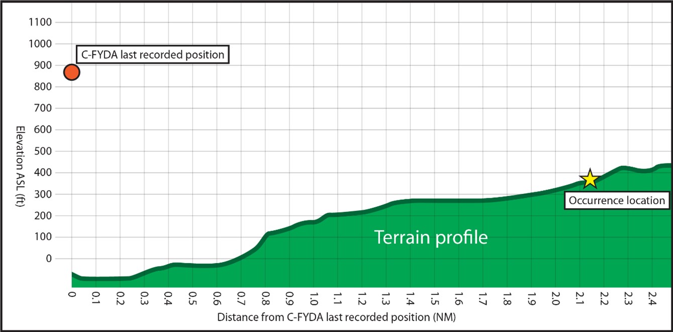
Source: TSB
Appendix B – Graphic area forecasts valid on the day of the occurrence
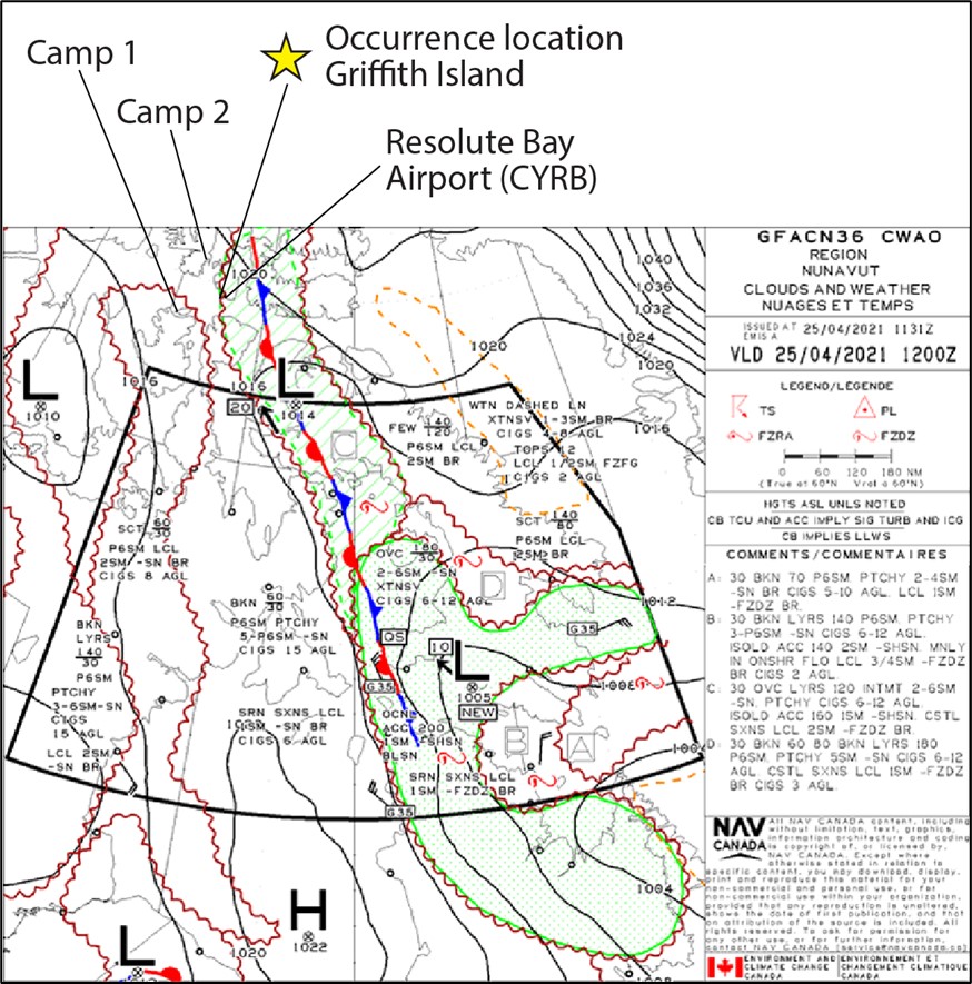
Source: NAV CANADA, with TSB annotations
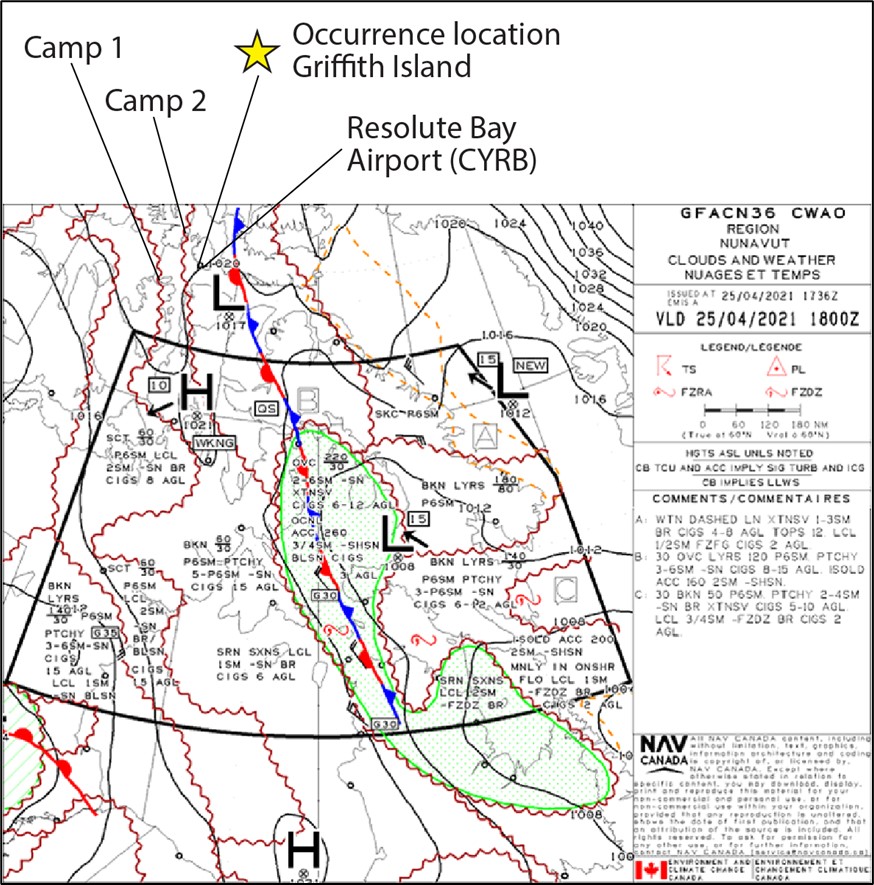
Source: NAV CANADA, with TSB annotations
Appendix C – Flat light task
| Task | Risks | Severity | Probability | Overall risk | Risk treatment | Residual risk |
|---|---|---|---|---|---|---|
| Flat light | Optical illusion Lose their depth-of-field and contrast in vision. Flat light can completely obscure features of the terrain, creating an inability to distinguish distances and closure rates. Can give pilots the illusion of ascending or descending when actually flying level. [See note 1 below] |
Significant | Occasional | Mitigatable | However, with good judgment and proper training and planning, it is possible to safely operate an aircraft in flat light conditions. [See note 1 below] | Acceptable |
| White Out | When a person becomes engulfed in a uniformly white glow. No shadows, no horizon or clouds and all depth-of-field and orientation are lost.* No visual reference. [See note 1 below] |
Catastrophic | Unlikely | Mitigatable | “Whiteout” is a phenomenon that can occur in such places as Labrador when a layer of cloud of uniform thickness overlays a snow or ice-covered surface, such as a large frozen lake. Light rays are diffused when they pass through the cloud layer so that they strike the surface from all angles. This light is then reflected back and forth between the surface and cloud, eliminating all shadows. The result is a loss of depth perception, the horizon becoming impossible to discern, and dark objects seeming to float in a field of white. Disastrous accidents have occurred under such conditions where pilots have flown into the surface, unaware that they were descending and confident that they could see the ground. [See note 2 below] | Acceptable |
Note 1: Taken from FAA’s Flying in Flat Light and White Out Conditions, 2001 and the Aeronautical Information Manual.
Note 2: Taken from NAV CANADA’s The Weather of The Canadian Prairies.
Source: Great Slave Helicopters’ Winter Operations operational risk profile template
Appendix D – Example of ForeFlight synthetic vision depiction
NOTE: This does not depict the occurrence location.
Source: ForeFlight
Appendix E – TSB recommendations related to prevent inadvertent flight into instrument meteorological conditions accidents Footnote 210
| Number | Recommendation | Current assessment | Status |
|---|---|---|---|
| A90-81 | The Department of Transport require verification of proficiency in basic instrument flying skills for commercially-employed helicopter pilots during annual pilot proficiency flight checks. | Unsatisfactory | Dormant |
| A90-82 | The Department of Transport revise the safety standards for commercial operations to include requirements designed to reduce the probability and seriousness of VFR-into-IMC accidents. | Fully satisfactory | Closed |
| A90-83 | The Department of Transport require all helicopters engaged in commercial passenger carrying operations be equipped with radar altimeters. | Unsatisfactory | Dormant |
| A90-84 | The Department of Transport require all commercially-operated helicopters to be equipped with appropriate instrumentation for the conduct of basic instrument flying. | Unsatisfactory | Active |
| A94-18 | The Department of Transport, in consultation with the aviation industry, implement a special safety campaign to inform the helicopter community of the inherent risks involved in the ad hoc practice of penetrating cloud/fog in VFR operations, particularly in mountainous regions. | Fully satisfactory | Closed |
| A94-19 | The Department of Transport place increased emphasis on achieving compliance with respect to VFR weather limits for commercial helicopter operations. | Fully satisfactory | Closed |
| A94-20 | The Department of Transport, in conjunction with industry, explore measures to counter attitudes that "pressing-the-weather" is an acceptable practice in commercial VFR helicopter operations. | Fully satisfactory | Closed |
| A96-12 | The Department of Transport require that pilots involved in air-taxi and commuter operations receive specialized training, including skills development, in making prudent decisions under deteriorating operational conditions. | Fully satisfactory | Closed |
| A16-08 | The Department of Transport amend the regulations to clearly define the visual references (including lighting considerations and/or alternate means) required to reduce the risks associated with night visual flight rules flight. | Satisfactory intent | Active |
| A16-10 | The Department of Transport require terrain awareness and warning systems for commercial helicopters that operate at night or in instrument meteorological conditions. | Satisfactory in Part | Active |
Appendix F – TSB investigations involving loss of spatial awareness during commercial helicopter flights Footnote 211
| Occurrence number | Date | Factual information about the occurrence | Location |
|---|---|---|---|
| A18O0134 | 2018-09-25 | Controlled flight into terrain Essential Helicopters Robinson R44 Raven II (helicopter), C-GMCT |
Toronto/Buttonville Municipal Airport, Ontario, 9 NM N |
| A15C0130 | 2015-09-08 | Collision with terrain Apex Helicopters Inc. Robinson R44, C-GZFX |
Foleyet, Ontario, 17 NM S |
| A13H0002 | 2013-09-09 | Collision with water Government of Canada, Department of Transport MBB BO 105 S CDN-BS-4 (helicopter), C-GCFU |
M’Clure Strait, Northwest Territories |
| A13C0073 | 2013-07-01 | Collision with water Custom Helicopters Ltd. Bell 206B (helicopter), C GQQT |
Gull Lake, Manitoba |
| A13H0001 | 2013-05-31 | Controlled flight into terrain 7506406 Canada Inc. Sikorsky S-76A (helicopter), C-GIMY |
Moosonee, Ontario |
| A12C0084 | 2012-07-04 | Controlled flight into terrain Sunrise Helicopters Incorporated Bell 206B (helicopter), C-GUIK |
Angusville, Manitoba, 6 NM SW |
| A12P0079 | 2012-06-01 | Loss of visual reference and collision with terrain Bailey Helicopters Limited Eurocopter AS 350 B2 (helicopter), C-FBHN |
Terrace, British Columbia, 14 NM W |
| A12W0031 | 2012-03-30 | Loss of control and collision with terrain Kananaskis Mountain Helicopters Ltd. Bell 206B JetRanger (helicopter), C-GLQI |
Loder Peak, Alberta, 0.4 NM NW |
| A11W0152 | 2011-10-05 | Continued visual flight into instrument meteorological conditions - Collision with terrain Rotorworks Inc. Bell 206B (helicopter), C-FHTT |
Drayton Valley Industrial Airport, Alberta, 1 NM S |
| A11W0070 | 2011-05-20 | Loss of control – Collision with water Campbell Helicopters Ltd. Bell 212 (helicopter), C–FJUR |
Slave Lake, Alberta, 12 NM W |
| A10Q0148 | 2010-09-01 | Loss of visual reference - Collision with trees Canadian Helicopters Limited Eurocopter AS 350 B2 (helicopter), C-GHVD |
Chibougamau, Quebec, 12 NM NW |
| A10Q0132 | 2010-08-17 | Loss of visual reference with the ground, loss of control, collision with terrain Héli-Excel Inc. Eurocopter AS 350-BA (helicopter), C-GIYR |
Sept-Îles, Quebec, 22 NM N |
| A10Q0133 | 2010-08-16 | Collision with sea Universal Helicopters Newfoundland Limited Bell 206L (helicopter), C-GVYM |
Clyde River, Nunavut, 40 NM NW |