Loss of control and collision with terrain
Beechcraft Bonanza V35B, N3804X
Senneterre, Quebec, 7 NM NE
The Transportation Safety Board of Canada (TSB) investigated this occurrence for the purpose of advancing transportation safety. It is not the function of the Board to assign fault or determine civil or criminal liability. This report is not created for use in the context of legal, disciplinary or other proceedings. See Ownership and use of content. Masculine pronouns and position titles may be used to signify all genders to comply with the Canadian Transportation Accident Investigation and Safety Board Act (S.C. 1989, c. 3).
Summary
On 29 July 2019, at 1555 Eastern Daylight Time, the Beechcraft Bonanza V35B aircraft (registration N3804X, serial number D-10358) departed Wittman Regional Airport, Wisconsin, United States, for a daytime visual flight rules flight to Danbury Municipal Airport, Connecticut, United States, with only the pilot on board. Shortly after takeoff, the aircraft began to deviate north of the planned route and subsequently into Canadian airspace. At 1912, while in the vicinity of a line of rain showers, thunderstorms, and lightning, the aircraft entered a right turn, descended rapidly and collided with terrain approximately 7 nautical miles northeast of Senneterre, Quebec.
At 2331, the Joint Rescue Coordination Centre in Trenton, Ontario, was notified of a missing aircraft and initiated search and rescue operations. The accident site was found 4 days later, on 02 August 2019. The pilot was fatally injured. The aircraft was destroyed. There was no post-impact fire. No signal was detected from the aircraft’s emergency locator transmitter.
1.0 Factual information
1.1 History of the flight
At 1555Footnote 1 on 29 July 2019, the Beechcraft Bonanza V35B aircraft (U.S. registration N3804X, serial number D-10358) departed Wittman Regional Airport (KOSH), Wisconsin, U.S., for a daytime visual flight rules (VFR) flight to Danbury Municipal Airport (KDXR), Connecticut, U.S., with only the pilot on board. Within minutes, the aircraft turned approximately 15° north of a direct flight path to KDXR.Footnote 2 At 1610, the aircraft climbed through 10 000 feet above sea level (ASL) and levelled off at approximately 11 500 feet ASL. As the flight progressed, the aircraft deviated toward the north and never regained a track or heading toward the original destination (Figure 1).
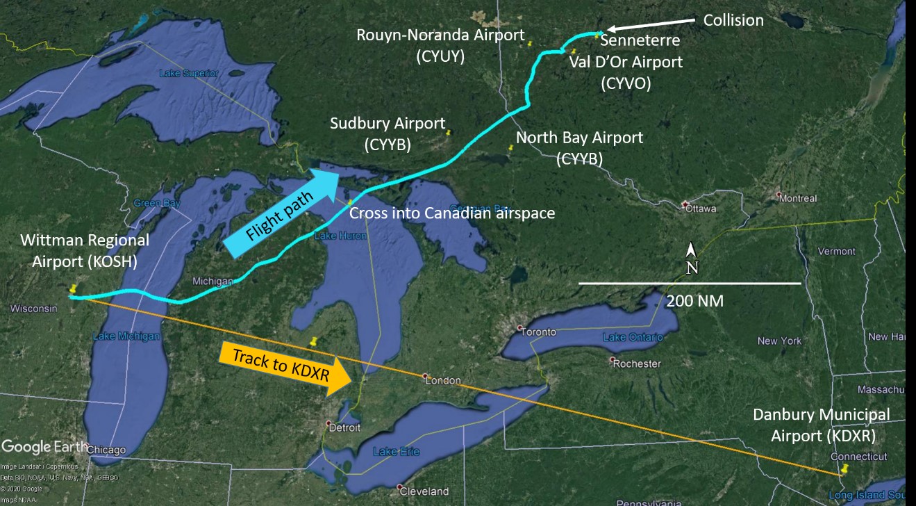
At 1727, just before entering Canadian airspace, the pilot contacted the Toronto Area Control Centre (ACC) and informed the controller that, in 20 nautical miles (NM), he would be turning 90° to the right to regain his track to KDXR. The Toronto ACC controller replied that a solid line of thunderstorms and lightning was visible on the radar and that he could not provide any indication of the best route to take. The pilot acknowledged the weather information and stated that he was “painting the weather.”Footnote 3 After having reached the northern shore of Lake Huron, Ontario, the aircraft turned north-northeast and flew between 2 Canadian airports: Sudbury Airport (CYSB), Ontario, approximately 20 NM to his left, and North Bay Airport (CYYB), Ontario, approximately 30 NM to his right.
At 1824, the pilot initiated a descent from 11 500 feet ASL and 4 minutes later, the aircraft had descended below 10 000 feet ASL. At 1837 and as the aircraft was flying over the province of Quebec, the Toronto ACC controller informed the pilot that radar services were terminated and instructed him to contact the Montreal ACC.
At 1842, the aircraft had descended to 7500 feet ASL and the pilot contacted the Montreal ACC. Because other aircraft were flying in the area, the controller asked the pilot if he was familiar with the Rouyn-Noranda Airport (CYUY), Quebec, or the Val d’Or Airport (CYVO), Quebec, which were nearby. The pilot replied that he was not.
Radio communications between the pilot and the Montreal ACC controller were limited and did not reveal any indication that the pilot was in distress. Due to the limitations in radar coverage below 8000 feet ASL in the area, the controller was unable to maintain radar contact with the occurrence aircraft. As a result, at 1844, the Montreal ACC controller provided the altimeter setting for CYVO and then cleared the pilot to switch to an en route frequency. The pilot replied by repeating the CYVO altimeter setting. There were no further transmissions from the pilot.
At approximately 1906, the aircraft flew past Senneterre, Quebec, level at 7000 feet ASL. Approximately 3 minutes later, the aircraft was in a gradual climb through 7500 feet ASL. At that point, the aircraft was flying at 160 knots calibrated airspeed (KCAS),Footnote 4 on an easterly heading. The aircraft then entered a slow turn to the left at 1.45° per second for approximately 75 seconds, which then increased to 4.36° per second for another 33 seconds. At 1910 the left turn continued into a descent, and the descending left turn continued until the aircraft reached 7200 feet ASL.
After turning approximately 250° to the left, the aircraft then immediately entered a climbing right turn and its speed decreased to approximately 100 KCAS while it climbed back to approximately 7900 feet ASL. As the right turn continued, the aircraft began to descend, the right turn steepened and its airspeed and descent rate increased rapidly. At 1912, the aircraft collided with terrain in a heavily wooded area approximately 7 NM northeast of Senneterre, 452 NM from KDXR.
Later that night, shortly after the aircraft’s planned arrival time at KDXR, the pilot’s family notified the U.S. authorities of the missing aircraft. The U.S. authorities then contacted Canadian air traffic control (ATC) services. At 2331, the Joint Rescue Coordination Centre (JRCC) in Trenton, Ontario, was notified of the missing aircraft and initiated a search and rescue (SAR) operation. The accident site was located 4 days later, on 02 August 2019. No signal was detected from the emergency locator transmitter (ELT), either immediately after the accident or during the search.
1.2 Injuries to persons
The pilot was fatally injured.
1.3 Damage to aircraft
The aircraft was destroyed by impact forces. There was no post-impact fire.
1.4 Other damage
Due to the elapsed time between the accident and the arrival of SAR personnel, the investigation was unable to determine either the presence or amount of fuel spilled.
1.5 Personnel information
The pilot was certified and qualified for the flight in accordance with existing U.S. Federal Aviation Administration (FAA) regulations. He received an FAA Airman Certificate (Private Pilot, Airplane Single-Engine Land) in 1999 and obtained an instrument rating in 2001. FAA records show that his last medical examination was in 2016 and that a BasicMed Comprehensive Medical Examination Checklist was completed in 2018.
The pilot had 20 years of experience as a general aviation pilot and flew approximately 100 to 150 hours per year. The investigation was unable to recover the pilot’s logbook and therefore could not determine the pilot’s total flying hours, flying hours on type, or instrument flying experience.
The pilot was a member of the American Bonanza Society and records indicate that he had completed the Beechcraft Pilot Proficiency Program, Inc., Approved Bonanza Recurrent CourseFootnote 5 in May 2007.
1.6 Aircraft information
1.6.1 General

The Beechcraft Bonanza aircraft was manufactured by Beech Aircraft Corporation of Wichita, Kansas, U.S. The model 35 Bonanza is a single-engine, low-wing monoplane with retractable landing gear. A distinguishing feature is its combined elevator and rudder, called a ruddervator, or V-tail.Footnote 6 The occurrence aircraft (Figure 2) was a Bonanza V35B model, manufactured in 1980. The occurrence pilot purchased the aircraft in 2001.
Records indicate that the aircraft was certified, equipped and maintained in accordance with existing regulations and approved procedures. The last annual inspection was completed on 28 September 2018.
| Manufacturer | Beech Aircraft Corporation |
|---|---|
| Type, model, and registration | Bonanza, V35B, N3804X |
| Year of manufacture | 1980 |
| Serial number | D-10358 |
| Certificate of airworthiness/flight permit issue date | 13 November 1980 |
| Total airframe time | 3742.47 (as of 28 September 2018) |
| Engine type (number of engines) | Teledyne Continental Motors, IO-520-BB, SN285789-R (1) |
| Propeller/Rotor type (number of propellers) | Hartzell, Three-bladed, PHC-C3YF-1RF (1) |
| Maximum allowable takeoff weight | 3400 lbs / 1542 kg |
| Recommended fuel type(s) | Aviation gasoline 100/100LL |
| Fuel type used | Aviation gasoline 100LL |
1.6.2 Range and endurance
The aircraft’s maximum range and endurance specifications are published in the Beechcraft Bonanza V35B pilot operating handbook (POH). The range profile performance chartFootnote 7 shows that the aircraft’s range could vary between 690 and 890 NM depending on factors such as environmental conditions, aircraft and fuel loading, engine power settings, and altitudes flown. The endurance profile performance chartFootnote 8 indicates that the time airborne could vary between 4 hours 54 minutes and 6 hours 27 minutes. It was reported that the aircraft had been fuelled to capacity before the occurrence flight.
The distance from KOSH to KDXR is 684 NM. On 14 July 2019, the pilot had flown that distance in approximately 5 hours. On the day of the occurrence, the pilot flew a distance of approximately 610 NM in 3 hours 17 minutes. Performance calculations give a potential remaining flight time available between 1 hour 37 minutes and 3 hours 28 minutes. The investigation concluded that it is unlikely the aircraft ran out of fuel.
1.6.3 Aircraft equipment
The aircraft was equipped with a Bendix/King KFC 200 autopilot system, an Avidyne IFD540 combined flight management (FMS)/global positioning (GPS)/navigation (NAV)/communication (COM) touchscreen system, a Garmin GPSMAP 396, a Garmin GTX-330ES (Extended Squitter) transponder, and an Appareo Aviation Stratus automatic dependent surveillance – broadcast (ADS-B) receiver.Footnote 9 The pilot also had a laptop and a tablet, which used the web-based flight application ForeFlight for flight planning and flight following.
The investigation could not determine if the autopilot system was used during the flight. It is likely that the pilot used the ForeFlight application in conjunction with the Avidyne IFD540 system for in-flight navigational purposes, including weather avoidance during the flight; however, the investigation could not determine to what extent. While the transponder and the ADS-B receiver could take advantage of ADS-B technology, the aircraft lacked sufficient antenna diversityFootnote 10 to be fully compatible with the NAV CANADA/Aireon ADS-B network.
The Stratus ADS-B receiver was capable of receiving weather information when in communication with the ground-based ADS-B network; however this service is only available in the United States. The pilot guides for most of the available Stratus receivers detail this limitation;Footnote 11,Footnote 12,Footnote 13,Footnote 14 however, it could not be determined if the pilot was aware.
1.6.4 Beechcraft Bonanza spiral dive characteristics
A spiral dive is a steep descending turn with the aircraft in an excessively nose-down attitude. A spiral dive may be recognized by an excessive angle of bank, rapidly increasing airspeed, rapidly increasing rate of descent, and increasing load factors.
The Beechcraft Pilot Proficiency Program, Inc. Approved Bonanza Recurrent Course includes a demonstration of the airplane’s spiraling characteristics, the technique for recovery, and the student’s practice of that technique. The spiral demonstration is explained in a handout and provides the following information:
The spiral demonstration shows the likely outcome if the airplane enters a steep bank but the pilot does not maintain altitude and airspeed. Spirals usually result from disorientation, attitude instrument failure, severe turbulence or thunderstorm encounters, or inattention, especially in instrument conditions. They are the natural result of an airplane that is stable in pitch but neutrally stable or unstable in roll. Beech piston airplanes have this characteristic. […]
Now, roll into a steep bank and let go of the controls. The airplane will immediately begin accelerating and descending downward, with rapidly increasing airspeed and vertical speed. It has no tendency to recover, but instead tries to return to its trimmed airspeed by pitching up relative to the airplane. This simply tightens the spiral and increases the load factor.Footnote 15
1.7 Meteorological information
1.7.1 General
The investigation was unable to determine what, if any, weather information the pilot obtained before departure. However, at the time of departure, the weather at KOSH showed VFR conditions.
A weather analysisFootnote 16 for the area and day of the accident determined that a broken line of showers and thunderstorms extended from Michigan into central Ontario and western Quebec, and was moving eastward at around 25 to 30 knots. The analysis concluded that near the thunderstorms and heavy showers, visibilities dropped to as low as 1½ statute miles (SM) and ceilings dropped to as low as 700 feet above ground level (AGL). The aircraft flew along the line of weather (Figure 3).

1.7.2 Weather near the accident site
Thunderstorms reached CYUY at around 1600 and CYVO at around 1745. By 1845, the aircraft was east of CYUY and flying toward CYVO at 7500 feet ASL. Thunderstorms reached the accident site at around 1850. At 1900, the aircraft was approximately 20 NM north of CYVO, the nearest reporting facility to the accident site; the accident occurred at 1912. Sunset was at 1956.Footnote 17
The investigation could not determine the exact weather that the pilot encountered. However, due to its proximity, it is likely that the pilot encountered weather similar to that reported at CYVO. The following weather reports were issued at CYVO in the hours leading up to the occurrence.
| Time | Wind (direction/ speed) | Visibility (SM) |
Sky condition | Temp (°C) | Dew point (°C) | Altimeter (inHg) / remarks |
|---|---|---|---|---|---|---|
| 1800 | 180°T/10 kt, gusting to 21 kt | 10 SM in light thunderstorms and rain | Scattered cloud layer at 3400 feet;* overcast ceiling at 9100 feet | 21 | 19 | 29.72 |
| 1821 | Variable/8 kt | 2½ SM in light thunderstorms and rain | Scattered cloud layer at 3300 feet, including cumulonimbus clouds; overcast ceiling at 8000 feet | 21 | 19 | 29.73 / Windshift 2200 feet; visibility 6 SM to the southeast, Pressure rising rapidly |
| 1833 | 040°T/8 kt, gusting to 19 kt; variable 290°T to 080°T | 4 SM in light thunderstorms and rain | Scattered cloud layer at 2000 feet; broken ceiling at 3100 feet, including cumulonimbus clouds; overcast cloud layer at 9000 feet | 21 | 19 | 29.71 / Pressure falling rapidly |
| 1900 | Variable/7 kt | 6 SM in light thunderstorms and rain | Few clouds at 1500 feet; broken ceiling at 5000 feet, including cumulonimbus clouds; overcast cloud layer at 8000 feet | 21 | 20 | 29.70 / Pressure falling rapidly |
| 1912 | 230°T/15 kt gusting | 2 SM in light thunderstorms and rain | Broken cloud layer at 3000 feet, including cumulonimbus clouds; overcast cloud layer at 8000 feet | 21 | 20 | 29.71 / Wind estimated |
* Cloud bases are reported as the height above the station in increments of 100 feet to a height of 10 000 feet, and thereafter in increments of 1000 feet.
1.8 Aids to navigation
According to NAV CANADA records, there were no reported anomalies or planned maintenance outages to navigation aids for the region encompassing the flight path within the Toronto and Montreal flight information regions.
In Canada, a flight plan or flight itinerary provides the sharing of aircraft and routing information and activates alerting services in the event the aircraft is overdue. In the U.S., flight itineraries are not used and while there are FAA regulations to file a flight plan for flights outside the U.S. or between the U.S and Canada, a flight plan is not required for a domestic VFR flight. The pilot had not filed a flight plan with ATC; however, he had informed his family of his take-off time, routing, and estimated landing time.
1.8.1 Automatic dependent surveillance – broadcast
Automatic dependent surveillance – broadcast (ADS-B) is an air traffic surveillance monitoring technology that is used to monitor both private and commercial air traffic around the world.
In the U.S., a ground-based ADS-B system uses a network of towers located throughout the country and relies on aircraft being within range and at an altitude with a direct line of sight of the towers. As of 01 January 2020, aircraft flying in most U.S. controlled airspace were required to be equipped with ADS-B Out.Footnote 18
In Canada, a ground-based ADS-B system is in use covering the airspace over Hudson Bay, Baffin Island, and the area between Labrador and Greenland. In recent years, Aireon, an international consortium of air navigation service providers, including NAV CANADA, has developed a space-based ADS-B technology. NAV CANADA began a phased implementation of space-based ADS-B to support air traffic surveillance in Canada in March 2019. In addition, Aireon’s global coverage will “allow rescue coordination centers to obtain GPS location and tracking data for ADS-B equipped aircraft in an alert, distress phase or emergency situation.”Footnote 19
Transport Canada (TC) has not mandated ADS-B use in Canada.Footnote 20 As recently as November 2020, NAV CANADA’s ADS-B performance requirements mandate does not indicate when implementation will occur. However, NAV CANADA is working with Transport Canada in an effort to facilitate the implementation and support an effective mandate.
At the time of the occurrence, space-based ADS-B surveillance was not operational at the Montreal ACC; however, it was operational in other areas of Canada, but only at flight level (FL) 290Footnote 21 and above. Controllers working the low-level airspace, through which the occurrence aircraft was flying, did not receive space-based ADS-B surveillance information on their displays. This was primarily because the targets were filtered out; controllers were not yet mandated to use the information for separation purposes. As a result, the Montreal ACC could not track the aircraft’s progress nor provide any surveillance service using ADS-B. The implementation of spaced-based ADS-B at the Montreal ACC began in January 2020 in high-level airspace at FL 290 and above.
1.8.2 Aireon Aircraft Locating and Emergency Response Tracking
Aireon offers an emergency aircraft locating service using ADS-B data and describes the service as follows:
Aireon Aircraft Locating and Emergency Response Tracking (Aireon ALERT) provides aircraft position information, upon request, to assist pre-registered authorities such as ANSPs [air navigation service providers], commercial aircraft operators/airlines, regulators and search and rescue organizations when an aircraft is determined by a registered user to be in an uncertainty phase, alert phase or distress phase.
Aireon ALERT provides the last known position / track, upon request, for an aircraft that has been determined to be in an uncertainty phase, alert phase or distress phase. […] Aireon ALERT makes it possible to precisely query the location and flight track of any ADS-B OUT 1090MHz equipped aircraft, regardless of region, location, terrain or status as an Aireon customer.Footnote 22
At the time of the occurrence, a typical report included the last 15 data points of the flight, taken at approximately 1-minute intervals (Figure 4 ).

Since the occurrence, Aireon has improved the Aireon ALERT report. In addition to providing the last 15 minutes of detected flight at 1-minute intervals, the last minute of flight now includes updates at 5-second intervals.
1.8.3 Aireon and NAV CANADA automatic dependent surveillance — broadcast data
ADS-B data was used to examine the occurrence aircraft’s flight path.
Using this track data, the investigation was able to determine that the final right turn was followed by a spiral dive without recovery. More specifically, the flight path showed that the right turn continued into a descent that became a tightening spiral dive of at least 1.5 compass rotations. The aircraft’s airspeed increased continuously and may have reached as much as 240 KCAS. The descent rate may have reached up to 20 000 fpm. The bank angle reached at least 90° right, and pitch angle may have reached 60° nose down. An airspeed of 240 KCAS is significantly greater than the aircraft’s never‑exceed airspeed (VNE) limitation of 195 KCAS,Footnote 23 placing the aircraft beyond its approved structural design envelope and posing a risk of exceeding the structural load limits during a recovery manoeuvre.
The last data point was captured at 1912:30. At that time, the aircraft was descending through 2325 feet ASL, about 1300 feet AGL. The collision with terrain likely occurred within 2 to 3 seconds of the last data point time.
1.9 Communications
No emergency distress call from the aircraft was recorded on the Toronto ACC or Montreal ACC frequencies.
1.10 Aerodrome information
Not applicable.
1.11 Flight recorders
The aircraft was not equipped with a flight data recorder or a cockpit voice recorder, nor was either required by regulations.
1.12 Wreckage and impact information
The occurrence site was located in a heavily wooded area at 48°28'19"N, 077° 02'52"W, more than 350 NM north of the intended track from KOSH to KDXR, and 452 NM from KDXR. The aircraft impacted trees at high velocity 32 feet before the collision with terrain and at an angle of approximately 30° below the horizon. The wreckage distribution extended approximately 85 feet.
Most parts of the aircraft, including the wings and the ruddervator, were located at the occurrence site. The engine was found in a crater approximately 6 to 10 feet deep. The engine, aircraft fuel system, flight controls, instrument panel, cockpit seats and seat belts were all found heavily damaged and highly fragmented. As a result, flight control continuity and engine control continuity could not be established. As well, no instrument switch positions could be determined. The propeller hub was fractured into pieces.
Examination of the site and wreckage showed that there was no in-flight breakup or separation of the wing or ruddervator. The investigation did not identify any pre-impact material failures or component malfunctions.
1.13 Medical and pathological information
There was nothing to indicate that the pilot’s performance was degraded by fatigue or medical factors.
1.14 Fire
There was no indication of a pre- or post-impact fire.
1.15 Survival aspects
The collision with terrain was not survivable due to the impact forces.
1.15.1 Emergency locator transmitters
The occurrence aircraft was equipped with an ELT capable of transmitting on 121.5 MHz and 243 MHz that was destroyed on impact. No functional testing could be completed on the unit due to the extent of damage.
As of 01 February 2009, Cospas-Sarsat Footnote 24 satellites no longer detect 121.5 MHz distress beacons and the occurrence aircraft was not equipped with a 406 MHz ELT; therefore, no signal could have been detected by Cospas-Sarsat.
1.15.2 Search and rescue
1.15.2.1 General
In Canada, SAR response is coordinated with the Canadian Armed Forces, the Canadian Coast Guard, police services (such as the RCMP [Royal Canadian Mounted Police], the Ontario Provincial Police, and the Sûreté du Québec), and volunteer organizations (such as the Civil Air Search and Rescue Association, and Sauvetage et recherche aériens du Québec). JRCC Trenton was responsible for the SAR response in this occurrence.Footnote 25
1.15.2.2 Joint Rescue and Coordination Centre Trenton
JRCC Trenton was notified that the aircraft was missing at 2331 on 29 July 2019, and initiated its SAR response. At 0049 on 30 July 2019, JRCC Trenton obtained some limited initial ground-based ADS-B data from the U.S. Air Force Rescue Coordination Center, which last recorded the aircraft’s GPS position and altitude at 1911:42. JRCC Trenton used this data point to determine the search area. This initial data matched data that was available on the internet through several different networks of private ground-based ADS-B receivers. The data point was at 48°28'02"N, 077°03'50"W, at an altitude of 7600 feet ASL, and was 4638 feet (0.76 NM) from the actual crash site (Figure 5).

JRCC Trenton used this initial data point as a last known position (LKP).Footnote 26 However, given the absence of a flight plan, limited radar coverage below 8000 feet ASL in the area, no ADS-B data available below 7600 feet ASL, no ELT signal, and no indication that the aircraft had crashed, JRCC Trenton was focused on locating a lost or missing aircraft. Based on the aircraft’s endurance, the overall search area was defined as an area with a radius of 250 NM. Dense tree canopy coverage made aerial visual search methods difficult and at times ineffective.
The resources allocated to the search included 20 civil and military aircraft, which collectively flew over 300 flight hours.
At 1759 on 02 August 2019, after searching for 4 days, JRCC Trenton was provided with enhanced space-based ADS-B data from the U.S. Civil Air Patrol, which included more details on the flight track and an updated LKP. This updated position was coincident with the last position in the Aireon ALERT report, at 48°28'25"N, 077°02'43"W, at an altitude of 2300 feet ASL and 850 feet (0.14 NM) from the actual crash site (Figure 6). The wreckage was not visible from the air, but SAR crews walked the ground to find the site.

1.15.2.3 Access to automatic dependent surveillance — broadcast data
NAV CANADA receives a pre-determined set of Aireon ADS-B data to support its surveillance activities over Canadian airspace and can also receive Aireon ALERT reports. The NAV CANADA Engineering Services Branch works in close collaboration with Aireon to develop, improve, and maintain the Aireon ADS-B capability. This work includes having access to a significant amount of ADS-B data. This enhanced data is considerably more precise than the information provided in an Aireon ALERT report but it is not readily available to clients. In addition, the branch is not mandated nor staffed to provide ADS-B data for SAR operations.
During the search, to assist in the SAR operation, JRCC Trenton requested and received voice and radar data from NAV CANADA. This request however did not include ADS-B data.
Space-based ADS-B is an emerging technology in Canada. NAV CANADA began a phased implementation of space-based ADS-B to support air traffic surveillance in Canada in March 2019. At the time of the occurrence, JRCC Trenton was aware that ADS-B technology had been available in Canada since March 2019, but also that not all aircraft operating in Canada were equipped with this technology. As a result, JRCC did not include ADS-B data in its data requestsFootnote 27 to NAV CANADA.
In addition, JRCC Trenton was not aware of the Aireon ALERT service. Therefore, it did not know that NAV CANADA had access to ADS-B data or Aireon ALERT data. JRCC Trenton was also not aware that this data could be requested from NAV CANADA or obtained by subscribing directly to the Aireon ALERT service.
1.16 Tests and research
1.16.1 TSB laboratory reports
The TSB completed the following laboratory reports in support of this investigation:
- LP209/2019 – NVM Data Recovery
- LP227/2019 – Flight Path Analysis
- LP249/2019 – Instrument Analysis
1.17 Organizational and management information
Not applicable.
1.18 Additional information
1.18.1 Visual flight rules flight into instrument meteorological conditions
TSB accident data shows that continued VFR flight into adverse weather or instrument meteorological conditions (IMC) represents a significant threat to aviation safety. Aircraft operating under VFR that continue into IMC are at risk of controlled flight into terrain and loss of control accidents.
The TSB examined its data to identify accidents involving pilots who were flying under VFR and proceeded into IMC. From 1992 to 2019, 168 accidents and 205 fatalities were identified.
1.18.2 Spatial disorientation
Spatial disorientation (SD) is defined as a pilot’s inability “to correctly interpret the aircraft’s attitude, altitude, or airspeed in relation to the Earth or other points of reference.” Footnote 28, Footnote 29
All humans require and receive sensory information from the visual system (the eyes), the vestibular system (the balance organs within the inner ears), and the proprioceptive system (known as “seat of the pants” – the pressure receptors throughout the body that help contribute to the overall sense of orientation). Footnote 30 Humans will process information from these systems to determine their position in time and space, and in relation to the surface of the Earth. Unfortunately, humans are susceptible to visual or vestibular illusions, which can affect how a person interprets the information received, seen or felt, that can result in SD. The visual or vestibular illusions relevant to this investigation include the leans, the Coriolis illusion and the graveyard spiral (spiral dive).
- The leans is a common illusion where, after a prolonged roll or turn, and upon returning to straight and level flight, the pilot may sense a turn in the opposite direction. SD “can occur when movement is below the sensory threshold for the semicircular canal (0.2-8.0 degrees per second), especially during slow rotational movement.” Footnote 31
- The Coriolis illusion is caused when the aircraft is in a prolonged roll or turn and the pilot abruptly moves his or her head out of the plane of rotation (e.g., down or back). The combination of the lengthy rolling or turning motion (stabilizing the fluid in the inner ear) and the sudden head motion (causing an opposite reaction within the inner ear) stimulates the vestibular system, creating a tumbling sensation. Footnote 32
- The graveyard spiral (spiral dive) is an insidious illusion where a pilot will initially not notice a wing drop (increase in bank) and the resultant lowering of the aircraft pitch attitude (increase in airspeed). This can result in a slow gradual descending turn with increasing airspeed. “As the aircraft spirals downward and its rate of descent accelerates, the pilot senses the descent but not the turn. With the bank angle having gradually increased, any control input only tightens the turn and increases the descent rate.” Footnote 33
In a degraded visual environment (such as intentionally or inadvertently flying into IMC) where a pilot is unable to maintain visual reference with the ground, these illusions can lead to improper flight control inputs and result in a loss of control. The strength of these illusions can be so intense that even a conscious cross-reference to flight instruments may be insufficient to prompt the pilot to apply the appropriate corrective input to the flight controls.
1.18.3 Situation awareness
Situation awareness (SA) is defined as “the perception of elements in the environment within a volume of time and space, the comprehension of their meaning, and the projection of their status in the near future.” Footnote 34
Maintaining SA is therefore a result of 3 separate processes. A pilot must first perceive information from the environment; second, establish the relevance of this information to the ability to achieve operational goals; and finally, use this information to project future states and events. In this way, a pilot maintains SA, allowing him or her to “plan ahead and prepare for contingencies,” Footnote 35 which leads to more effective decision making. All 3 processes involve information-processing stages at which shortcomings may occur and that may result in incomplete or inadequate SA.
A pilot’s training, knowledge, experience, and preconceptions are some of the individual factors that influence his or her understanding of a situation. Footnote 36 Other issues facing pilots when flying—such as workload, distraction, time pressure, equipment malfunctions, changes in weather conditions, unfamiliarity with a geographical area and flying at night—can also affect SA.
1.18.4 Pilot decision making
Pilot decision making (PDM) is a cognitive process to select a course of action between alternatives. Many decisions are made on the ground, and a well-informed pre-flight choice avoids the need for a much more difficult in-flight decision. An important component of PDM is good SA.
Other factors can affect PDM, such as family or work pressure to arrive at the destination by a certain time; financial implications when landing at an alternate airport, such as requiring aircraft services, transportation, meals or accommodations; or administrative issues such as clearing customs when landing in another country.
1.18.5 Plan continuation bias
Plan continuation bias is best described as “the unconscious cognitive bias to continue with the original plan in spite of changing conditions,” Footnote 37 or “a deep-rooted tendency of individuals to continue their original plan of action even when changing circumstances require a new plan.” Footnote 38 Once a plan is made and committed to, it becomes increasingly difficult for stimuli or conditions in the environment to be recognized as necessitating a change to the plan. Often, the stimuli or conditions will appear obvious to people external to the situation; however, as workload increases, it can be very difficult for a pilot caught up in the plan to recognize the saliency of the cues and the need to alter the plan. Footnote 39
1.18.6 Hypoxia
In this occurrence, the pilot flew above 10 000 feet ASL, but no higher than 11 500 feet, for 2 hours 18 minutes. The pilot subsequently descended below 10 000 feet ASL and was operating below that altitude for 44 minutes before the accident. Although an oxygen bottle was found at the crash site, it could not be determined if it was used for the portion of the flight flown above 10 000 feet ASL. With the FAA regulation only requiring the use of supplemental oxygen above 12 500 feet ASL, and the pilot having selected and flown at a cruising altitude of 11 500 feet ASL, it is possible that the pilot elected not to use supplemental oxygen.
The investigation concluded that hypoxia was unlikely to have played a role in this accident.
1.19 Useful or effective investigation techniques
In this occurrence, space-based ADS-B data helped in reducing the search area, locating the downed aircraft, and allowed the TSB to reconstruct the flight path.
2.0 Analysis
The pilot was certified and qualified for the flight in accordance with existing U.S. Federal Aviation Administration regulations. Records indicate that the aircraft was certified, equipped and maintained in accordance with existing regulations and approved procedures. The investigation determined that there was no in-flight breakup or separation of the wing or ruddervator.
The flight profile and weather data suggest that the pilot was deviating around the weather in an attempt to bypass or outrun a moving line of thunderstorms and lightning. It is likely that the aircraft subsequently entered instrument meteorological conditions (IMC) and the pilot became spatially disoriented. The aircraft entered a spiral dive and collided with terrain.
The analysis will identify factors that could have played a role in the occurrence and accident sequence. Factors affecting the search and rescue will also be discussed.
2.1 Plan continuation bias affecting situation awareness and pilot decision making
The numerous northerly heading deviations were all followed by gradual corrections to regain an easterly heading. These heading corrections all proved unsuccessful in either crossing the line of weather or regaining a suitable track toward the original destination of Danbury Municipal Airport (KDXR), Connecticut, U.S.
These continued unsuccessful attempts and the surrounding adverse weather conditions were cues that should have suggested a change to the pilot’s original plan, such as deviating to one of the several suitable alternate airports along the route, or continuing the flight under instrument flight rules (IFR). Once he was in Canadian airspace over the province of Quebec, reaching his intended destination of KDXR—more than 450 nautical miles away—would not have been possible. The commitment to the original plan indicates that the pilot’s decision making was likely affected by plan continuation bias. Consequently, he continued the flight, likely until he no longer could maintain flight in visual meteorological conditions.
The pilot’s decision making was likely affected by plan continuation bias, which led him to continue a visual flight rules (VFR) flight in adverse weather conditions.
2.2 Visual flight rules flight into instrument meteorological conditions
VFR flight into IMC represents a significant threat to aviation safety. Aircraft operating under VFR that continue into IMC are at risk of controlled flight into terrain and loss of control accidents.
In addition to deviating around the weather to bypass or outrun the moving line of thunderstorms and lightning, the aircraft may also have been flying above or between cloud layers. The multiple course alterations indicate that the pilot was likely attempting to remain flying under VFR and avoid entering IMC.
If the pilot inadvertently entered cloud or IMC, flight with visual reference to the ground would no longer have been possible, and a transition to flying solely by reference to instruments would have been required.
Flying safely in IMC requires training and regular practice. While the pilot did have an instrument rating, the investigation could not determine whether or not he had recent experience flying in these conditions or that he attempted to transition to IFR.
If pilots do not have recent experience flying in IMC, they may not possess the skills and proficiency required to do so, increasing the risk of loss of control and accident.
2.3 Spatial disorientation
Spatial disorientation (SD) is a common hazard in aviation that can lead to a loss of control. Flying in a degraded visual environment, such as in IMC, without reference to the ground increases a pilot’s susceptibility to SD.
In the slow left turn prior to the spiral dive, if the occurrence pilot was experiencing a visual or vestibular illusion, his flight control input to stop the turn or correct the aircraft back to straight and level flight could have led to the right turn and descent in the opposite direction. The slow gradual right turn that followed would have led to a spiral dive if the pilot increased the pitch to address the rate of descent without recognizing the increasing angle of bank.
The automatic dependent surveillance – broadcast (ADS-B) data shows that the aircraft descended in a spiral with an increasing rate of descent indicative of a spiral dive. The flight path suggests that the pilot likely experienced SD from a visual or vestibular illusion and, as a result, the aircraft entered a spiral dive and collided with terrain.
2.4 Search and rescue
At the time of the occurrence, ADS-B data was not included in any Joint Rescue Coordination Centre (JRCC) data requests to NAV CANADA. The investigation determined that the knowledge level of ADS-B, including space-based ADS-B, and Aireon was limited within the JRCCs and the search and rescue (SAR) community. Staff at JRCC Trenton were not aware that the ADS-B Aireon Aircraft Locating Emergency Response Tracking (ALERT) service was operative; that NAV CANADA had access to ADS-B data or Aireon ALERT data; or that this data was available by either requesting it from NAV CANADA or by subscribing directly to Aireon ALERT services.
If SAR authorities do not access or use data from emerging technologies, such as space-based ADS-B, in a timely manner, there is a risk that following an accident, potentially life-saving search and rescue services will be delayed.
3.0 Findings
3.1 Findings as to causes and contributing factors
These are conditions, acts or safety deficiencies that were found to have caused or contributed to this occurrence.
- The pilot’s decision making was likely affected by plan continuation bias, which led him to continue a visual flight rules flight in adverse weather conditions.
- The flight path suggests that the pilot likely experienced spatial disorientation from a visual or vestibular illusion and, as a result, the aircraft entered a spiral dive and collided with terrain.
3.2 Findings as to risk
These are conditions, unsafe acts or safety deficiencies that were found not to be a factor in this occurrence but could have adverse consequences in future occurrences.
- If pilots do not have recent experience flying in instrument meteorological conditions, they may not possess the skills and proficiency required to do so, increasing the risk of loss of control and accident.
- If search and rescue authorities do not access or use data from emerging technologies, such as space-based automatic dependent surveillance – broadcast, in a timely manner, there is a risk that following an accident, potentially life-saving search and rescue services will be delayed.
4.0 Safety action
4.1 Safety action taken
4.1.1 Joint Rescue Coordination Centre
Department of National Defence search and rescue stakeholders (i.e., the Directorate of Flight Safety, 1 Canadian Air Division, the Canadian Joint Operations Command, and the 3 Joint Rescue Coordination Centres [JRCCs]) were made aware of the Aireon Aircraft Locating Emergency Response Tracking (Aireon ALERT) service and the requirement to specifically request automatic dependent surveillance – broadcast (ADS-B) data.
Since this accident, all 3 JRCC have registered accounts with Aireon ALERT and coordinators routinely include such queries when investigating overdue or missing aircraft.
This report concludes the Transportation Safety Board of Canada’s investigation into this occurrence. The Board authorized the release of this report on . It was officially released on .