
Marine Investigation Report M00M0106
Grounding
Tug Keta V
Liverpool, Nova Scotia
The Transportation Safety Board of Canada (TSB) investigated this occurrence for the purpose of advancing transportation safety. It is not the function of the Board to assign fault or determine civil or criminal liability. This report is not created for use in the context of legal, disciplinary or other proceedings. See Ownership and use of content.
-
Table of contents
Summary
On 03 October 2000, the tug Keta V was in transit off Nova Scotia. That evening, it endeavoured to stop at Liverpool for the night. The tug headed for Moose Point, south of Liverpool Bay, and proceeded toward Eastern Head, where it ran aground. No casualties or major pollution were reported as a result of this occurrence.
Factual information
Particulars of the vessel
| Name | "Keta V" |
|---|---|
| Official Number | 311874 |
| Port of Registry | Québec |
| Flag | Canada |
| Type | Tug |
| Gross TonnageFootnote 1 | 236 |
| Length | 28.2 m |
| Draught | 3.0 m |
| Built | 1961, Saint John Shipbuilding & Drydock Co., Ltd. |
| Propulsion | Two Stork twin-screw diesel engines totalling 662 kW |
| Cargo | None |
| Crew | 7 |
| Owner | Industries Verreault inc., Les Méchins, Quebec |
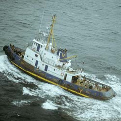
Photo 1. The tug Keta V
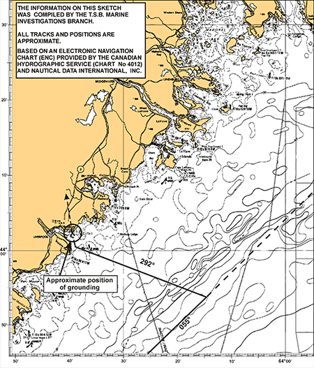
To enable the master to plan his approach to Liverpool Bay, Canadian Hydrographic Service general chart L/C 4012, covering the area from Yarmouth to Halifax, Nova Scotia, was used as a reference. Although there are large-scale chartsFootnote 3 covering Liverpool Bay, these were reportedly not found on board the tug. L/C 4012 is a small-scale chart, so it does not show any of the references required to navigate the Liverpool Bay approaches. Because the master had never sailed into this harbour, he based his approach plan on his experience in other ports and on information he had received some time earlier from an acquaintance who once worked for a paper manufacturer in Liverpool. The master and the helmsman were in the wheelhouse.
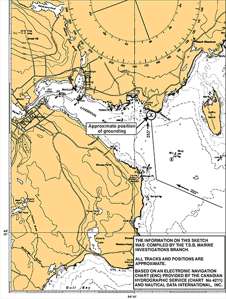
The approach plan was to proceed on a heading of 292° T, to a position southeast of Moose Point. The engines were set to reduced speed. (Appendix B.) On arriving at Moose Point, the master altered course to 353° T and headed for Eastern Head. While under way, the master's primary concern was to watch for presumed range lights indicating the entrance to Liverpool Harbour, which, according to him, should have been seen on the port side. The range lights were not seen. The tug maintained heading, and at 2328, it grounded on a rock shoal off Eastern Head.
Engines astern was ordered, and the vessel refloated itself. The hull was damaged to the point where the capacity of the pumps was insufficient to keep up with the water flooding into the engine compartment. Once the flywheel was in the water, the main engine was stopped by the crew, the anchors were dropped and the deck openings were closed. The first mate communicated with Halifax Marine Communications and Traffic Services (MCTS) on VHF channel 16 and used a cell phone to advise them of the situation and request immediate assistance. The MCTS centre immediately broadcasted a Mayday relay.
Meanwhile, the seven members of the crew donned their immersion suits and boarded the inflatable liferaft. Watch was maintained on board with a portable VHF radio on channel 16 and a cell phone. The Keta V capsized and sank a short time later in position 44°02'23" N, 064°39'24" W.
Halifax Rescue Coordination Centre dispatched five vessels for the operation. Canadian Coast Guard Auxiliary Lady Kim from the local reserve unit was the first at the site, followed by Canadian Coast Guard Ship (CCGS) Hudson, which sent its fast rescue craft to pick up the crew of the Keta V. When the seven members of the Keta V crew were on board, CCGS Hudson proceeded to Halifax.
Bridge Resource Management
In essence, bridge resource management (BRM) is the efficient deployment of all available resources to safely carry out a task. The elements that come into play are attentiveness, the task to be performed, stress, attitudes and risks. BRM recognizes that safety and operational effectiveness are influenced by individual, organizational and regulatory factors.
Optimal management of these factors has a direct impact on the following four elements that are crucial to the outcome of an operation:
- situational awareness (recognizing and defining the nature of the problem);
- metacognition (examining and evaluating one's own cognitive activities or decisions);
- shared mental models (getting others involved in problem solving); and
- resource management (understanding the tasks to be carried out, the priority level of each task, and the resources that are required and available).
A good BRM program covers several crucial areas, including promoting and sustaining team spirit, communication and decision-making processes, workload management, situational awareness, shift work and workplaces.
Promoting and Sustaining Team Spirit
In a team, work is shared, tasks are performed more quickly and efficiently, and the performance of the team surpasses that of an individual working alone. The individual characteristics of team members are important. Research has shown that it is during team training that modes of communication and interaction are established.Footnote 4 Once established, the process continues and leads to activities that are likely to maintain effective (or ineffective) group communication mechanisms. Because the master was alone on the bridge with the helmsman, the first mate could have been tasked effectively, given the circumstances.
Communicating and Making Decisions as a Team
Making decisions as a team involves some degree of co-management. In this occurrence, the master elected to make all decisions by himself.
Workload Management
The tasks essential to safe navigation are assigned to different individuals who are in the best position to carry them out, so that no member of the bridge personnel will have to bear a workload that exceeds his/her capacity. The master did not call upon the first mate to assist on the bridge.
BRM Training
None of the crew on board the Keta V had undergone BRM training, nor is such training mandatory. However, Transport Canada encourages ship owners to have the crew trained, and courses approved by the department are available.
Damage
The vessel went down a few seconds after the crew abandoned it. Attempts to refloat the Keta V were unsuccessful. The tug was a total loss.
No significant damage from a diesel oil spill was reported by Environment Canada, as a result of the sinking. However, spill prevention measures were put in place around the nearby fish farming area.
Certification
The vessel was staffed, certified and equipped in accordance with existing regulations.
Master's History
The master had navigated mainly on the Restigouche River in Chaleur Bay, New Brunswick. He was retired but worked on contract from time to time. Since 1984, he has held a master's certificate for vessels not exceeding 350 gross tons.
Weather information
A low-pressure area developed about 250 nautical miles off of the Nova Scotia coast on 03 October 2000. Moved by winds in the Liverpool area, the low backed from northeast to north to north west and peaked at gale force during the overnight hours. Seas built to 3 to 4 m at about the same time. Visibility was good.
Analysis
Decision to Enter Port
After a telephone conversation with the company operations manager, and in view of the adverse weather in the area, the master elected to put in at Liverpool. Even though he did not have a detailed marine chart on hand, he decided to put in at Liverpool Harbour, assuming that he could use visual references in the way of range lights, which had been mentioned by an acquaintance, and buoys.
Using the global positioning system, a radar and a small-scale chart, the master was on the lookout for presumed range lights and buoys to guide him to the harbour entrance. But when the tug was within the harbour approaches, no range lights could be seen to guide the tug because none exist to facilitate the entrance to Liverpool Harbour.
Nearly all of the master's experience was gained in the same physical environment. The nature of his work and the environment in the port of Dalhousie did not offer him the opportunity to increase and diversify his field of professional knowledge. He was on one of his first voyages outside his area of local knowledge. His lack of experience outside his home port and inadequate knowledge of BRM greatly diminished his chances of safely completing the voyage.
The master's decision was influenced primarily by the suggestion of the operations manager. However, the master should have informed him clearly that he did not have adequate references to enter Liverpool Harbour.
Use of Marine Charts
Small-scale charts are intended for offshore navigation only. They contain enough detail, but they only allow the mariner to locate harbour approaches. Approaches are made on a large-scale chart with an inset showing a detailed plan of the harbour, as recommended in the Charts and Nautical Publications Regulations.5 Although large-scale charts covering the Liverpool Harbour area are published, these were not on board and, therefore, could not be used. The basic principles of seamanship require that a vessel should not attempt to enter a port without the largest-scale current marine chart of the area.
Lack of Training in Bridge Resource Management
A careful watch over the movement of a vessel is indispensable to safe navigation in confined waters. Time is a very important factor in the execution of vessel manoeuvres. It is essential, therefore, that each member of the bridge personnel clearly understands his/her role and ensures that all information significant for the conduct of the vessel is promptly conveyed to the person charged with pilotage or navigation.
Because the first mate was not on the bridge, the master was on his own. Deprived of the support of an effective team, the master was left with little room for error.
Situational Awareness
Situational awareness means having an accurate perception of the factors and conditions that affect the behaviour of a vessel and its crew over a given period of time. In simpler terms, it means knowing what is happening around you.
Safe completion of a voyage depends on the level of situational awareness of the person who has the conduct of the vessel. Ease and quality of communication are essential if optimum situational awareness is to be maintained. It is essential that each member of the bridge personnel does everything possible to support the person in charge and maximizes that person's situational awareness.
The master of the Keta V did not make use of all the information available to him to make an accurate assessment of the situation. Knowing that he did not have a chart of the appropriate scale, he did not refer to Sailing Directions, which was on board and does not mention range lights appropriate for the approach to Liverpool Harbour. Also, he did not make adequate use of navigational instruments, particularly the radar and echo sounder, to help him evaluate potential hazards in the Liverpool Harbour approaches.
To navigate safely, the person responsible for the conduct of a vessel must be constantly aware of his/her situation. That means he or she must be on the alert for signals and signs that provide important information, such as position, speed and hazards. After focussing all of his attention on one specific element (that is, finding presumed range lights), the master lost situational awareness and was unable to react to a dangerous situation that was gradually developing in front of him.
Company Operating Procedures and Safety Management System
The safe operation of a vessel, the safety of the crew and other occupants, and environmental safety require close cooperation and a healthy working relationship between shipboard personnel and the shipowner's personnel on shore. An effective safety management system must mobilize shipboard and shore managers, and must utilize the skills, attitudes and motivation of all concerned at every level.
Non-convention vessels operating within Canadian waters are not required to have a full-scale safety management system, in compliance with the International Safety Management Code or other regulatory requirements. The need for non-convention ships to have a safety management system in place was recognized by several owners and charterers of Canadian vessels, who have voluntarily put such a system in place.
Findings
Findings as to causes and contributing factors
- The master's experience was limited to Dalhousie Harbour, greatly diminishing his ability to undertake this coastal voyage.
- The decision to enter Liverpool Harbour was influenced by a non-shipboard person, and no risk assessment was done before this decision was made.
- The approach to the entrance to Liverpool Bay was made without using a larger-scale chart, which was not available on the Keta V.
- The principles of bridge resource management were not applied. As the master was unassisted by the chief officer, he was relying solely on his own performance, foregoing the potential for team work and leaving little room for error.
- No members of the crew had been trained in bridge resource management, nor was that training mandatory.
Safety Action Taken
Following this occurrence, the shipowner has placed on board its vessels an official document that is to be filled out by the crew with all pertinent details of equipment, safety equipment and procedures. The purpose of this documentation is to ensure that all crew members are aware of procedures and the functioning of all of the vessel's equipment. Also on board is a description of the role of each crew member, both as a watchkeeper and in emergency situations. A checklist is also provided, covering proper maintenance and inspections required on all equipment and machinery.
This report concludes the Transportation Safety Board's investigation into this occurrence. Consequently, the Board authorized the release of this report on .
Appendix A - Small-Scale Chart Used on the Keta V
Appendix B - Chart of the Occurrence Site
1. Units of measurement in this report conform to the International Maritime Organization (IMO) standards or, where there is no such standard, are expressed in the International System (SI) of units.
2. All times are Atlantic daylight time (Coordinated Universal Time minus three hours).
3. Charts 4379 and 4211 of the Canadian Hydrographic Service.
4. Robert L. Helmreich, and Clayton H. Foushee. "Why Crew Resource Management? Empirical and Theoretical Bases of Human Factors Training in Aviation," Cockpit Resource Management, E. Weiner, B. Kanki, and R. Helmreich, eds. San Diego, CA: Academic Press, 1993.